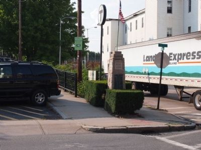
Erected in Honor of
Alfred Johnson, U.S.N.
and
John B. Morin, U.S.M.C.
The first from Attleboro
to die in action
World War II
November 15, 1942
In the South Pacific area
December 15, 1942
On Guadalcanal Island
Dedicated to . . . — — Map (db m59281) HM
Angell Park
Cyril M. Angell
2nd Lieutenant U.S. Air Services
Killed in action May 14th 1918
in Boucanville, France
First Officer from Attleboro to die in WWI — — Map (db m58124) WM
Dedicated to the memory of the first member of Company I, 101st infantry 26th Division to give his life for his country.
Enlisted May 24 1917
Died Dec 17 1917 — — Map (db m57926) HM
Everett Southworth Horton
Born June 15th 1836 - Died June 3 1911
Major Everett Southworth Horton was born in Attleborough Mass. on June 15, 1836. He attended public schools until the age of sixteen, when he began working in his father's . . . — — Map (db m65896) WM
In Honor of
Russell K. Garland Pvt. November 14, 1944
Louis J. Muccio Pfc. September 16th 1944
Who died in the service of their country. They stand in th unbroken line of patriots Who have dared to die that freedom may live, and grow, and . . . — — Map (db m59939) HM
For the men of Attleboro
who gave their lives
in the service of their
Country in Vietnam
Joseph E. Nimiroski 12/18/65
Richard C. Glidden 02/13/67
Robert E. Burns 05/13/67
Gary F. Flynn 09/13/67
Francis M. Driscoll . . . — — Map (db m229607) WM
For thirty six years (1647-1683) prominent in the affairs of the town of Rehoboth: representing the town in the house of deputies in the Plymouth Colony: when these lands were bought from Wamsutta Chief Sachem of the Wampanoags (1661) he was active . . . — — Map (db m57929) HM
In memory of the citizens of Attleboro who died in service to their country 1950 The Korean War 1953 Donald S. Brander Henry V. Camira John Fernandes Armand A. Frigon Donald F. Givens Arthur J. LaPorte Douglas P. Miner Bradford E. Tyndall You . . . — — Map (db m66250) WM
Dedicated
In Honor of the Employees of the
L.G. Balfour Company
Who Served in the Armed Forces of
The United States During World War II
and
In Memory of Those Who Made
The Supreme Sacrifice — — Map (db m70336) WM
Keeping faithful watch, this revered image of Mary has stood at the entrance to LaSalette Seminary (formerly Attleboro Springs Sanatorium),welcoming generations of brothers, priests, seminarians, pilgrims and visitors, inviting all still to submit . . . — — Map (db m55904) HM
These arches replace the last wooden bridge on the main line constructed in 1880
Henry A. Whitney pres't.
Albert A. Folsom sup't.
George F. Folsom Eng'r. — — Map (db m55671) HM
Major Thomas J. Deegan Memorial Bridge
Dedicated November 11, 1963
Major Thomas J Deegan, United States Air Force, Born August 1, 1925 in Attleboro, Massachusetts, who, in the service of his country, sacrificed his life to spare the lives of . . . — — Map (db m65897) WM
To Perpetuate the memory of the Revolutionary War Soldiers buried in this Old Kirk Yard
William Balcom •
Jacob Balkom •
Hezekiah Bishop •
Zephanian Bishop •
Zephanian Bishop Jr •
Daniel Blanding •
Noah Blanding •
Darius Briggs • . . . — — Map (db m57933) HM
In honor of the Hebronville Men and Women who served their country in World War II and in memory of those who made the supreme sacrifice.
Let all who come after see that they shall not be forgotten. — — Map (db m92195) WM
The images carved into the granite represent prisoners of war, armed forces missing in action, and the victims of the attack on America. The granite for the memorial was quarried in PA. The granite was carved and polished in VT. The millwheel weighs . . . — — Map (db m66252) WM
The family of Dr. James M. Solomon is buried here. An obelisk, where the names of the family members are listed, is in the burial yard. The earliest known burial was 1836. Dr. Solomon was the founder of Solomon Sanitarium which was located at the . . . — — Map (db m85875) HM
To the memory of those who faithfully served their country in the war with Spain The Philippine insurrection and the China relief expedition.
1898-1902
All were volunteers — — Map (db m57023) HM
Was erected near here in 1828
the geographic center of the town at that time
Committee Selectmen
Noah Claflin Elkanah Briggs
Abijah M. Ide Samual Cushman
Ellis Blackington . . . — — Map (db m52405) HM
Left column In honor of our fallen in the Great War 1914-1918 Ruth Holden Albert H. Allen Cyrill M. Angell Harry Attarian Elmer G. Baker Charlton M. Bliss Peter Boivin Harry L. Boyce Earle I. Brown Percy E. Cobb Arthur N. Crosby Leroy C. Estee . . . — — Map (db m66255) WM
Dedicated to the memory of Lewis Harry Mullaney and Harry Lewis Mullaney, twin brothers, who gave their lives in the service of their country in World War II.
PFC Lewis Harry Mullaney entered the armed forces on July 18, 1942, he went overseas . . . — — Map (db m57928) HM
Built in 1827 by Col. Willard BlackintonStone Placed
by Attleboro Historic Commission
Given to the city of Attleboro
by
Mr. and Mrs William A. Nerney
1970 — — Map (db m72444) HM
Center podium - Attleboro Veterans Memorial Common Dedicated May 28, 1992 Flagpole - Rededication of the War Memorial Flagpole by the family of Joseph E. Nimiroski in honor of all Attleboro Veterans Column 1 - World War I Column 2 - World War II . . . — — Map (db m66256) WM
On this site a field served the Washington Rifle Corps, off an on, from 1815 to 1841. The regular Attleborough Militia also used it as a training field. — — Map (db m251601) HM
Opened in 1907, Joseph L. Sweet who also provided a permanent endowment, gave the land for the library. A public subscription drive raised funds for the original construction. The library's collection includes many works relating to the history of . . . — — Map (db m251604) HM
The former Attleboro Refining Company building was built in 1899 for Harold D. Baker. Handy & Harmon Co. purchased the building in 1968 and used the building until the facility was turned over to the Attleboro Chamber of Commerce in 1976. As part of . . . — — Map (db m251602) HM
This smokestack replica is a symbol of the many industries which made Attleboro a world-renowned manufacturing center. Once a small farming community, the town of Attleborough's population grew as entrepreneurs established textile mills and shops . . . — — Map (db m251579) HM
This tavern played an important role in Attleboro's early history. One such event was the organizational meeting of the "Washington Rifle Corps" 4th Regiment, 2nd Brigade, 5th Division. On June 24, 1815, an "L" of the tavern was dedicated for the . . . — — Map (db m251605) HM
In 1743, the members of the original church who lived in this part of town asked to be set off as the East Parish. By 1748, a meeting house was ready and the Rev. Peter Thatcher accepted the call as its first minister. The meetinghouse, "for the . . . — — Map (db m251598) HM
The first parsonage for East Parish (East Attleborough) was built in 1822 at what was 41 South Main Street for the East Parish Church's third minister, Rev. John Ferguson. Rev. Ferguson lived here with his wife and eleven children for thirteen . . . — — Map (db m251597) HM
What Is Global Warming?
One of the more dangerous aspects of Global Climate Change is Global Warming. This refers to the long term rise in the Earth's overall temperature. Generally, it is understood that the excessive use of fossil fuels, . . . — — Map (db m251581) HM
In loving memory of Lynn and all those who perished on 9/11. We cannot let this one evil act outshine the inherent goodness of mankind. Lynn let peace begin with you and continue with us. — — Map (db m251580) WM
This train station was built in 1906 and still serves several hundred train passengers daily. A tunnel for foot passage once connected the north and south bound stations. The Station was accepted onto the National Register of Historic Places in 1989. — — Map (db m251584) HM
This train station was built in 1908. The upper floor served passengers of south bound trains while the American Railway Express Co. used the lower floor. The building closed to railroad service in the 1970s. In 1985, it was purchased and made into . . . — — Map (db m251582) HM
The city's main post office was built in 1916. In October 1991, it was closed when the post office was moved to Pleasant Street. The Park Street building, which is on the National Register of Historic Places, was sold to the City of Attleboro on . . . — — Map (db m251600) HM
The building of this church began in 1770 on the eastern edge of the Great Cornfield of the Pocanocket Indians. Construction was halted during the American Revolution and the church was used as soldiers farmed and sheepfold. Completion was in 1798. . . . — — Map (db m66342) HM
Dighton Council Oak
Meeting Place of the Wampanoag Indians
Here King Philip met with his braves. This tree marks the center of the “old field”. Near here was the largest Indian settlement in Dighton. — — Map (db m301420) HM WM
Northern apex of Eight Mile Purchase surveyed by Myles Standish June 1640.
(lower marker)
On this spot in 1640 Miles Standish waited while one of his men cobbled his worn shoes. They were here surveying the Eight Mile (Taunton) . . . — — Map (db m307797) HM
Lowney Common
Graciously donated to the Citizens of Mansfield in 1917 by
Walter M. Lowney
1855 - 1921
Internationally known candy manufacturer
Founder and president of the Walter M. Lowney Company
He was . . . — — Map (db m159211) HM
Mansfield Bell of Freedom Dedicated on Veterans Day, November 11, 2019 This Bell was made by Meneely & Company of West Troy, N.Y. in 1889, weighs approximately 1,000 pounds, stands three feet tall and three feet wide at the base.
The . . . — — Map (db m160009) WM
Here in the old red brick school house was held the first service of worship by the Mansfield Congregational Church May 20, 1828
This tablet was placed in memory of that service
May 20, 1963 — — Map (db m58178) HM
1941 World War II 1945
In memory of these comrades
who gave their lives so that
Liberty shall not perish
from the Earth
Merrill V Arnold • Edward F Bessom • Mariano P Carneval • Angelo Cataloni • Ramie D Chavaree • Clinton A Davison . . . — — Map (db m158696) WM
September 11, 2001
Shanksville, PA New York, NY Washington, DC
Remembering a day when terror struck, bravery was defined and a country united. For those who were lost, for those who lost family and friends. For those protecting our . . . — — Map (db m158669) HM WM
In memory of
Cpl. Guido R. Liberatore U.S.M.C
Sgt. Wilfred F. Liberatore U.S.M.C.
S/Sgt. John L. Liberatore U.S. Army
World War II — — Map (db m158968) WM
The Purple Heart Medal Was Originated by General George Washington, Commander-In-Chief Of The Continental Army By Order from His Newburgh, New York Headquarters On August 7, 1782 For Distinguished Valor And Designated As The Badge Of Military . . . — — Map (db m158290) HM WM
In Honor and Memory of All the Victims of September 11 2001
United in Memory
Dedicated to those who were lost in New York City
May We Never Forget
Dedicated to those who were lost in Pennsylvania
Dedicated to those who were lost in . . . — — Map (db m195792) HM
To Commemorate
The Loyalty to Country:
The Self Sacrifice: The
Heroism of the Men of
North Attleborough
Who Fought to Preserve the
Union in the Days of the
Civil War
1861 — 1865
( west side )
The demands for loyalty to . . . — — Map (db m195790) WM
1914 1918
In a Righteous Cause They Have Won
Immortal Glory and Have Nobly Served
Their Nation in Serving Mankind
In Memoriam
Becker George E. · Black Howard · Blais Frederick S. · Brennan Eugene P. · Brown James A. · Carlson Carl · Carr . . . — — Map (db m195793) WM
In honor of the four hundred fifty six citizens of North Attleborough who devoted themselves to the cause of freedom and served their country in the World War
Achin Antonio · Achin Henry J. · Allen Ira G. · Allen Robert J. · Allen . . . — — Map (db m195797) WM
In Honor of
The Citizens of the
Town of North Attleborough
Who served their country in
World War II
Died in Service
Avery Arthur R · Barry John C · Barth Charles W · Batchelder Robert K · Baxter Roland N · Beaupre Robert V · Bishop Harold . . . — — Map (db m195796) WM
Plymouth Colony
This monument, erected by order of the government to perpetuate the place on which the late station or angle tree formerly stood.
The commissioners appointed by the old colonies of Plymouth and . . . — — Map (db m298870) HM
Circa 4000BC
Natives of this area made tools from red felsite rock.
1669-1771
The Allen, Capron and Mann families owned this property. The Mann family burial ground still remains close by.
1772
Stephan Draper built a homestead . . . — — Map (db m57747) HM
Top PlaqueThis marker
is given by Massachusetts Society
Daughters of the American Colonists
in recognition of
The role this historic building played
in the area's early growth
presented: September 13 1969 Bottom Plaque . . . — — Map (db m55680) HM
The First Burial Ground is the presumed buying place of Norton's pioneer settler's.
William Witherell, who died in September 1691, is buried in the West end of the burial ground. When the land was passed to Nathaniel Witherell by his father,the . . . — — Map (db m52379) HM
The Native American Sachem, Metacomet of Pokonoket, called King Philip by the English, Sachem or chief of the Wampanoag people is reported to have used this area as a stopping place. It provided a natural fortress for his many visits to the . . . — — Map (db m56217) HM
The land which comprises this cemetery dates back to June 1702, and is the original town common. Originally called "The Common," this land consisting of approximately five acres, is the first land set apart for common use in Norton. Situated on the . . . — — Map (db m56462) HM
This historic area along Stony Brook was named Chartley before 1700. The name is thought to be related to the iron business, which thrived in this area.
In 1695, the Taunton North Purchase granted to Thomas and James Leonard land along the . . . — — Map (db m55989) HM
Winneccunnett Pond is the only sizable, natural body of water in Norton, Massachusetts. Winneccunnett is a Native American word meaning "the place of the black geese." A Native American village was established on the north end of the pond long . . . — — Map (db m56459) HM
1917 1919
This Memorial
Is Placed Here to Commemorate
Those Who Entered the Service
Of Their Country from Raynham
During the World War
★Danforth Chester
Ashley, Harold A. · Barker, A. L. · Bombardier, Edmond · Bradshaw.Rh · . . . — — Map (db m209712) HM
1941 1945
This Memorial
Is Placed Here to Commemorate
Those Who Entered the Service of
Their Country from Raynham
During World War II
Ahrens, Gordon · Ahrens, Richard · Ahrens, Rodman C. · Alegre, Daniel M. · Anderson, Charles E. · . . . — — Map (db m209696) WM
Built by James Leonard. Originally owned by twenty-three of Taunton's first settlers. Operated 1777 to 1876 by Hon. Josiah Dean and his descendants as sole owners. — — Map (db m297827) HM
Former site of the Anawan House, once called the Lewis Tavern built ca. 1835 as a rest stop for travelers between Taunton and Providence Plantations.
The Anawan House and inn served the public until July 1970. In February 1971 the building was . . . — — Map (db m55683) HM
Site of capture of the Wamponoag Indian Chief Anawan by Captain Benjamin Church on August 28th 1676, thus ending King Philip's war — — Map (db m44921) HM
The name "Bad Luck" (origin unknown) has been associated with this area since the early 1700's. The Beverly and Kelton families operated a water powered saw mill for many years on the North side of the pond beginning in the 18th century.
Bad Luck . . . — — Map (db m56246) HM
In 1720, Jonathan Bliss moved here from South Rehoboth and established a sawmill on the East Branch of the Palmer River with a homestead nearby. This homestead was one of the first in the area, and Bliss called it " my farm in the woods" the mill . . . — — Map (db m56247) HM
Block House No. 2. From 1675 - as seen in 1782. On the rise behind this sign was a fortified house surrounded by a palisade during the King Philip's War. This enclosure was a place of safety against Indian attack for the settlers in the Palmer's . . . — — Map (db m299476) HM WM
The ruins of the old dam are all that remain of the once busy Perry Turning Mill. This mill originally operated as a saw mill in a joint venture by Aaron Cole and Ezra Perry. Perry bought out Cole's share in he early 1800's, and raised the dam, and . . . — — Map (db m56249) HM
Plain St. now crosses what was once sawmill pond.
On a cold New Years day in 1830, 14 new converts to the nearby Oak Swamp Baptist Church were baptized by being immersed in the pond through a hole cut in 14" of ice — — Map (db m55905) HM
This one room school built in the 1840's and used by the town of Rehoboth until 1937. An extension of 14 feet at the rear was made in the 1920's. During Rehoboth's 325 anniversary in 1968 the school was restored and donated to the preservation of . . . — — Map (db m44925) HM
When the British occupied Newport, RI. during the Revolution they often threatened the surrounding towns with raids or "alarums" as they were called. When a raid began a system of beacon fires were lit to warn the militia in neighboring towns to . . . — — Map (db m55911) HM
About 200 feet south of this spot is a natural oven shaped hole in a rock. According to local tradition, Indians used this as a bake oven and to parch their corn. — — Map (db m55684) HM
Nearby runs Mine Brook named after an iron mine established here in 1696 by the Leonards, a famous iron monger family from Norton and Taunton.
The ore dug at this site called bog iron, was found in the swamp and brook. The Leonards hauled the ore . . . — — Map (db m55679) HM
During the American Revolution, a large white oak called "the Liberty Tree" stood near this place, which was then near the edge of a field. Beacons warning of trouble in Rhode Island could be seen by watchers at nearby Horton's Signal. After . . . — — Map (db m55918) HM
Rehoboth's second Meeting House,built in 1773,was located in the present cemetery. It replaced the Lake St Meeting House, and was used for town meetings and church services. The site included a stable, a cemetery west of the meeting house, a militia . . . — — Map (db m55656) HM
in 1810 a group of Rehoboth Citizens established Palmer River Manufacturing Company. A cotton spinning mill on the site of the old Joshua Smith grist and saw mill the mill was enlarged about 1826 and began manufacturing fine cotton cloth, as the . . . — — Map (db m44924) HM
This town pound maintained by Col. Frederick Drown for many years. Stray cattle were kept here until retrieved by their owners.
The Wheeler family ran a pot ash business nearby. — — Map (db m55912) HM
It was known as Butterworth Falls in the colonial days. Deacon Thomas Carpenter and later the Perry family maintained the saw-gristmill-turning shop here for almost 200 years — — Map (db m55686) HM
Redway Plain is named after James Redway, who settled here in the early 1700's. Originally the plain included this field, The Faxon Farm Field,and the Village Cemetery. Neither Winthrop Street or Pond Street existed before 1828.
From colonial . . . — — Map (db m56243) HM
Founded by Josiah Millerd in 1731. For over 140 years neighborhood farmers had their corn ground into meal and their logs sawn into lumber at this mill. — — Map (db m55917) HM
Framing for this church had begun at Peckham Street, when disgruntled Oak Swamp people took away the timbers in the night and raised the church here. — — Map (db m55913) HM
659 entries matched your criteria. The first 100 are listed above. Next 100 ⊳