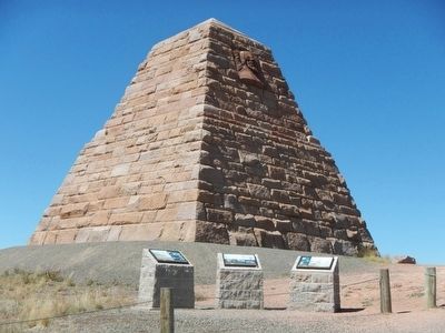
Commissioned by the Union Pacific Railroad, the Ames Monument is a memorial to the Ames brothers, Oakes and Oliver, for their contributions to the building of the Transcontinental Railroad. Their strong support, drive and influence were . . . — — Map (db m89647) HM
This area of southeast Wyoming is rich in history, geology and recreational activities. Within a short distance from this point, sites abound of early day events that have shaped the western heritage of this area, including the Arapaho and . . . — — Map (db m68052) HM
At first glance, the Ames Monument may seem out of place on this high, wind-swept setting. If you step back and view the Monument from a distance, you will notice its design and shape mimic the surrounding features of the mountain landscape. The . . . — — Map (db m89645) HM
The Sherman Mountains are erosional remnants rising above the general level of the surface of the Laramie Range. The flat topped characteristic of the range resulted from beveling during an ancient erosion cycle. Bedrock here is granite, a . . . — — Map (db m287129)
Completed in 1882 at a cost of $65,000. this monolithic, 60-foot high granite pyramid was built by the Union Pacific Railroad Company. It stands on the highest elevation (8,247 feet) of the original transcontinental route. Until 1901, when the . . . — — Map (db m308142) HM
The granite rocks to the west are more than a billion years old (Pre-Cambrian in age). The sedimentary rocks to the east are some 10 million years old (Late Miocene in age). After the mountains were elevated, some 20,000 feet of rocks were eroded . . . — — Map (db m92157) HM
Construction of the Transcontinental Railroad across the United States was one of the most significant historic events of the 1800s. Built almost exclusively with manual labor and hand tools, the cross-country railroad took only four years to . . . — — Map (db m89646) HM
This tree was growing out of a crevice in the rock when the Union Pacific Railroad built its original main line fifty feet south of this rock in 1868.
The fence and cable were provided by the Union Pacific Railroad Co. at the request of the . . . — — Map (db m95273) HM
This small pine tree that seems to be growing out of solid rock has fascinated travelers since the first train rolled past on the Union Pacific Railroad. It is said that the builders of the original railroad diverted the tracks slightly to pass by . . . — — Map (db m62159) HM
The architecture of the Woods Landing Dance Hall reflects the Scandinavian heritage of this area. Typical of Scandinavian construction, this log hall exhibits peeled and rounded logs with stepped and notched corners. Chinking was not necessary . . . — — Map (db m153399) HM
Built in 1869 for the Methodist Episcopal Church, this edifice is likely the oldest church building in Wyoming.
It originally was located across the street where the Elks Lodge now stands. — — Map (db m76783) HM
In the late 1800's, the saloons, dance halls and alleys of Laramie were packed
with a cast of colorful women who entertained men for a living. Meet 5 of
these women and hear about their lives. Make sure to see all 16 locations on
the Legends of . . . — — Map (db m280731) HM
This monument commemorates the sesquicentennial of Lincoln's birth by the State of Wyoming in 1959 Charles W. Jeffrey, M.D., Rawlins - Wyo. Donor Robert I. Russin, Sculptor — — Map (db m47144) HM
This bronze sculpture captures the moment when Chief Washakie first raises his lance challenging Crow Chief Big Robber to a duel.
The Battle of Crowheart Butte was ignited when Crow Chief Big Robber and his braves refused to leave an area . . . — — Map (db m95342) HM
Wyoming has a pretty remarkable suffrage history. Without a lot of fanfare, Wyoming women stepped up with rights equal to men on all counts because of the impressive Suffrage Act of 1869. Come learn more!
Wyoming Women's History House . . . — — Map (db m280736) HM
From 1849 through the end of the 19th century, thousands followed the Overland Trail into Wyoming, across the Laramie Plains, to a toll bridge near tree on the Laramie River. The historic crossing of the marshy plains consisted of a corduroy road . . . — — Map (db m89621) HM
The history of the American West recognizes Washakie as one of its most remarkable leaders. Revered for statesmanship and respected in battle, he united his people into a significant political and military force. A skilled orator and charismatic . . . — — Map (db m95347) HM
Laramie women who served first on a jury — March 1870
Amelia Hatcher, Jane Hilton, Mary Mackel, Annie Monehan, Sarah Pease, Eliza Stewart
The first woman bailiff — March 1870
Martha Symons Boies
The first woman voter with full . . . — — Map (db m280749) HM
In 1875, the inmates of the Wyoming Territorial Prison constructed a dwelling for the warden and guards. The dwelling, worth $3,000, consisted of six rooms - a kitchen, dining room, and four bedrooms. On July 3, 1877, Laramie's local newspaper, . . . — — Map (db m95312) HM
The 1907 photograph to the left shows, from left to right, the boiler plant (foreground), broom factory, outhouse, blacksmith and candle shop, and kitchen extension.
Before shops were built inside the stockade, inmates worked outside cutting . . . — — Map (db m95327) HM
On June 24th, 1975, the Laramie Sentinel reported, "An icehouse has been built in the bank a few feet from the prison, and some 60 tons of ice were taken out and stored in it for the use of the prison. This, also done by convict labor, . . . — — Map (db m95314) HM
Steam was used to heat the new cellblock and administration wing added to the prison in 1889. Though the boiler was only intended to serve the new addition it heated the entire prison (both cellblocks). Working beyond its capacity, the old boiler . . . — — Map (db m95325) HM
The original kitchen was constructed in 1873. The bakery ovens sat directly behind it. The extension to the left of the kitchen was added by 1894 and used for a variety of things: store room, icehouse, guards' dining hall, carpentry shop, and . . . — — Map (db m95330) HM
Four plaques are located around a monument locate on the Ivinson Mansion grounds in Laramie, Wyoming.
Laramie Woman's Club, organized in 1898, honors Laramie's "First Ladies" who pioneered civic and political responsibility by women . . . — — Map (db m89657) HM
The emigrant trails across Wyoming were a vital link in the transcontinental migration of an estimated 250,000 Americans in the 19th century, and opened the area to settlers. The Indians resented this intrusion and threatened these . . . — — Map (db m67994) HM
Tall trees, short trees, shrubs, grasses and flowering plants -- mountains, canyons, river bottoms, and prairies -- all intermingle to form the landscape. The greater the variety of landforms and vegetation, the more homes or habitats there are for . . . — — Map (db m47149) HM
The first person to cross America
by motorcycle, riding from
San Francisco to New York City
May 16-July 6, 1903
George A. Wyman was the first person to make a transcontinental journey across
America by means of a motorized vehicle. Wyman . . . — — Map (db m287438) HM
"That there should be a Lincoln Highway across this country is the most important thing"
In memory of Henry B. Joy
The first president of the Lincoln Highway Association
Who saw realized the dream of a continuous improved highway from the . . . — — Map (db m84887) HM
This monument commemorates the Lincoln Highway, America's first transcontinental automobile road, and Henry Bourne Joy, the first president of the Lincoln Highway Association (1913). Joy, also president of the Packard Motor Car Company, is . . . — — Map (db m47145) HM
This plaza honors the historic women of Laramieband Wyoming and recognizes the state, national and worldwide history they have made through their actions and achievements.
On September 6, 2003 the plaza was dedicated and named for the following . . . — — Map (db m280738) HM
Founded in 1868 upon the arrival of the Union Pacific Railroad, Laramie was named after the fur trader Jacques LaRamie. The first female jurors served here in 1870 after Wyoming Territory in 1869, for the first time in history, gave women full . . . — — Map (db m67993) HM
Founded in 1868 upon the arrival of the Union Pacific Railroad, Laramie was named after the fur trader Jacques LaRamie. The first female jurors served here in 1870 after Wyoming Territory, in 1869, for the first time in history, gave women full . . . — — Map (db m280774) HM
This marker is made up of a dozen plaques embedded in a cement patio and a map of historic Laramie also embedded in patio. As each plaque has the same format, only a few of them have been illustrated.
1810-1820
French Canadian . . . — — Map (db m76849) HM
This area of Albany and Laramie Counties is noted for its rich agricultural history. The forests and rolling hills were home to large sheep and cattle herds from the mid 1800s into the 1900s. After the Civil War, trees harvested from what is now the . . . — — Map (db m47150) HM
This Monument
Marks the Site of
Fort Sanders
Established September 5, 1866
Abandoned May 18, 1882
Named in Honor of
Brigadier General
William P. Sanders
Erected by the
State of Wyoming
and
Jacques Laramie Chapter . . . — — Map (db m67995) HM
Laramie circa 1868: 23 saloons. Not 1 Church.
In 1896, Laramie was in need of a little reform. Constructed from local limestone, St. Matthew's Cathedral was built to tame the unruly masses. And today, it sits as the highest Cathedral in the . . . — — Map (db m280730) HM
On May 25, 2019, this location was dedicated to Steen Gronlund, Citizen Driver. Steen was born in Copenhagen, Denmark, but moved to Canada with his family at age nine. Settling in a small farming community in Saskatchewan, Steen was soon hauling . . . — — Map (db m275912) HM
The first in the west through which a telephone line was run. The first conversation over this line was held in 1882 between Bill Nye at Laramie and Hon. E. E. Warren at Cheyenne. — — Map (db m47148) HM
The legendary war-horse of the Nez Perce has a rich history dating as far back as 20,000 years. Detailed images of spotted horses can be found on cave walls in southern France. In Austria, a scabbard dating back to 1000 B.C. was found decorated with . . . — — Map (db m95348) HM
The title “The Franchise” refers to the recognition and bestowal of the right of women to vote under full civil equality with men. In 1869, Wyoming became the first state or territory to grant this right.
This act was inspirational to both . . . — — Map (db m76744) HM
The route that later became the Overland Trail was followed in 1825 by William Ashley and members of the Rocky Mountain Fur Company, who entered the Laramie Valley from the south, forded the Medicine Bow River near Elk Mountain, and crossed the . . . — — Map (db m89623) HM
The Purple Heart Medal was originated by General George Washington on August 7, 1782 for distinguished valor and is now awarded only to members of the armed forces of the United States, who have been wounded in combat against an armed . . . — — Map (db m47143) HM
Built in 1888, this Folk Victorian is accentuated with
clapboard, decorative shingle work, half-timbering,
nine-over-one windows and three porches. It was
originally the home of the vice-president of the
University of Wyoming, John D. Conley, . . . — — Map (db m305422) HM
In remote areas of Albany County, Wyoming, passenger trains carrying mail, payroll monies, and express deliveries were tempting targets for bandits. On June 2, 1899, the Union Pacific Overland Flyer No. 1 was flagged down near Wilcox Station, east . . . — — Map (db m89659) HM
To the north lies Como Bluff - "The Dinosaur Graveyard" - one of the greatest and well known fossil beds of dinosaur remains in the world. There paleontologist of the 19th century discovered and unearthed many excellent fossil specimens of the . . . — — Map (db m89665) HM
In memory of those who
passed this way to win
and hold the West
on the Fort Halleck-
Fort Laramie Road
Frontier town of
Rock Creek 10 miles
north east — — Map (db m89658) HM
This stone marks the place where The Overland Stage Line on its way to the West, June 1862 - 1868, crossed the Colorado-Wyoming boundary line. — — Map (db m89620) HM
Edwin Thomas Thorne
May 20, 1941 - December 29, 2004
Tom Thorne earned a BA in zoology and D.V.M. at Oklahoma State
University. In 1968, he started work as a wildlife veterinarian with
the Wyoming Game and Fish Department. There he . . . — — Map (db m285420) HM
Elizabeth Storm Williams
November 15, 1951 - December 29, 2004
Beth Williams earned her D.V.M. at Purdue University in 1977 and
moved on to Colorado State University for a residency in veterinary
pathology and a Ph.D.
Soon . . . — — Map (db m285421) HM
It is one of the most commonly asked questions here – and with good reason. Those who grew up watching western movies expect to see a fort with a large wooden stockade. Like many other aspects of Hollywood westerns, the walled military fort . . . — — Map (db m87076) HM
This 1889 winter scene shows buildings along the west side of the Parade Ground which housed Fort Laramie’s officer complement – hence, “Officers Row”. RIGHT TO LEFT, the “Burt” House, the “Surgeon’s” . . . — — Map (db m87031) HM
Some days since I received a messenger from [Sinte Gleska], head chief of the Brule Sioux, saying that his daughter had died on the way here and had begged her Father to have her grave made with the whites . . . Wishing to do him honor . . . . — — Map (db m87041) HM
The large structure built on this site in 1885 – pictured shortly after completion – was put to many uses. The section on the far right was used as a schoolroom for officers’ children. The central portion housed the Headquarters . . . — — Map (db m87005) HM
“French, Spanish and Indian and mixed are very common here and all languages are being jabbered in promiscuous interchange.”Charles B. Darwin, Fort Laramie, June 28, 1849 Métis (ma-tes’) – of mixed race, particularly, mixed Native . . . — — Map (db m87012) HM
High ranking officers commonly kept chickens for their own use. The consumption of chickens and eggs provided a welcome change from meals of wild game and tough army beef. Individual soldiers and cooks utilizing company funds could purchase . . . — — Map (db m87024) HM
Originally intended as housing for the commanding officer, this building was divided into a duplex when the C.O. chose to remain in another new dwelling. As such, the quarters was completed in 1870 at which time high-ranking officers and . . . — — Map (db m87009) HM
The building before you is the only surviving enlisted men's barracks at Fort Laramie. The building proper was completed in late 1874 and was designed to provide quarters and other needed support facilities for two companies of soldiers, The . . . — — Map (db m71018) HM WM
This building was completed in 1884. It was built as a commissary storage facility. As such it would have been primarily divided into two large storerooms: one for meat and one for flour, rice, and beans. Three or four smaller rooms would have been . . . — — Map (db m71017) WM
Crossed the Laramie ford this morning and passed through the fort registering our names and found that . . . 16,913 men, Women 235, Children 242, Wagons 4,672, Horses 14,974, Mules, 4,641, Oxen 7,427, Cows 465, passed, besides nearly as many . . . — — Map (db m86975) HM
As the main outpost of the U.S. Government on the Northern Plains, Fort Laramie served as an official meeting ground between the United States of America and the sovereign tribes of the Northern Plains. The first great treaty negotiation, the . . . — — Map (db m86984) HM
. . . the articles of trade consist, on the one side, almost entirely of buffalo robes; and, on the other, of blankets, calicoes, guns, powder, and lead, [and] . . . cheap ornaments such as glass beads, looking-glasses, rings, vermillion for . . . — — Map (db m86968) HM
A military post on the Oregon Trail June 16, 1849-March 2, 1890. This monument is erected by the State of Wyoming and a few interested residents — — Map (db m100065) HM
Fort Laramie was perhaps the single most important location in America’s expansion into the west. Founded in 1834 as a trading post, it became a military fort in 1849. Until it closed in 1890, Fort Laramie influenced major events in the history of . . . — — Map (db m71016) HM
The epic story of America’s western expansion played out on a grand scale at Fort Laramie, where the North Platte and Laramie Rivers meet.
Fort Laramie was first established in 1834 as a private fur trading post. By the 1840’s, it served as an . . . — — Map (db m79778) HM
In 1834, Robert Campbell and William Sublette established the first fort at the confluence of the North Platte and Laramie Rivers. Christened Fort William, the post was rectangular, measuring only 100 by 80 feet. Hewn cottonwood logs 15 feet high . . . — — Map (db m86958) HM
In the 1880’s the Surgeon General determined that the privy vault - - “That most objectionable and dangerous nuisance” - - was a threat to the soldier’s health. His concern had been prompted by the accumulated reports from disgusted . . . — — Map (db m86996) HM
The remains of the first guardhouse constructed in 1850, at Fort Laramie were discovered by workmen in 1960 during restoration of the “new” guardhouse. This site is a good example of the structural changes that occurred during the forts . . . — — Map (db m87001) HM
We cannot afford to purchase wagons and teams as in times past. I am consequently thrown back upon my old plan – to make hand-carts, and let the emigration foot it . . . Brigham Young, 1855 Between 1856 and . . . — — Map (db m86981) HM
In answer to the perpetual need for housing, construction of an enlisted men’s barracks commenced at the opposite end of these foundation ruins. The barracks were extended in this direction as more men were assigned. Kitchens, mess halls, . . . — — Map (db m87030) HM
Here on December 25, 1866
John (Portugee) Phillips
finished his 236 mile ride to obtain troops for the relief of Fort Phil Kearny after the Fetterman Massacre. — — Map (db m79773) HM
Restored here to the 1850-1862 period, the magazine is among the oldest surviving structures at Fort Laramie. It was during this early period that George Balch, 1st Lieutenant, Ordnance Corps, sent the following report to the Assistant Adjutant . . . — — Map (db m168269) HM
Mary Elizabeth Homsley was born near Lexington, Kentucky, July 20, 1824. She move with her parents, Jacob and Sarah Oden, to Truxton, Missouri, where she was married to Benjamin Franklin Homsley in 1841. In April 1852, accompanied by Mary's . . . — — Map (db m98361) HM
As long as you behaved yourself and performed your duty as a soldier, you got along alright.Sergeant Perley S. Eaton, 3rd Cavalry Few soldiers completed their enlistments without experiencing the military justice system. Minor . . . — — Map (db m87003) HM
Between the years 1847 and 1868, most of the approximate 80,000 Mormon Pioneers passed through Fort Laramie. This was the first stop for the vanguard company after leaving Winter Quarters, (near Omaha) Nebraska.
In June, 1847, after following a . . . — — Map (db m79776) HM
Before you stand the remains of a six-unit apartment building constructed in 1884. Built for the fort’s senior noncommissioned officers and their families, this new structure provided the best housing available for married enlisted men on post. . . . — — Map (db m168233) HM
This 1885 photograph shows the buildings constructed on this site in 1881. Previous adobe structures, built in 1855, were left standing as rear wings. On the far left was the Commanding Officer’s residence. Between 1881 and 1890 it was successively . . . — — Map (db m87026) HM
This bridge was a vital link between Cheyenne, Fort Laramie and the Military outposts, Indian Agencies and gold fields of the Black Hills, Dakota Region. — — Map (db m5747) HM
This graceful old structure, built in 1849, is the oldest standing building in Wyoming. It was nicknamed “Old Bedlam” because of boisterous sounds supposedly heard while it was occupied by bachelor officiers.
Shown in an 1889 photograph, “Old . . . — — Map (db m79774) HM
The parade ground was the center around which a variety of utilitarian buildings were constructed between 1849 and 1885. Though intended as a center of activities for the post with its parades and drills, Fort Laramie’s parade ground was not in . . . — — Map (db m87002) HM
The job of building, maintaining, and supplying military posts belonged to the Quartermaster’s Department. The QMD was responsible for quarters, barracks, construction, infrastructure, transportation of personnel and supplies, and the procurement . . . — — Map (db m87105) HM
I knew little about reading, spelling and arithmetic, while I was well versed in lightning, thunder, vapor and geography. Guy V. Henry Jr. on growing up at frontier military posts Wyoming’s first public school opened at Fort . . . — — Map (db m168463) HM
Fort Laramie began as a dusty, drab frontier outpost as pictured above in the 1868 photograph. However, by the 1880’s, the Army had embarked upon a major cleanup and improvement campaign. The delightful results are evident in the 1887 view – . . . — — Map (db m87020) HM
Through a succession of accidental fires, Fort Laramie’s sawmills gained a reputation of being oll-fated. The lime-grout building erected upon this site in 1887 was the last of several such structures that sheltered stream engines used for sawing . . . — — Map (db m87044) HM
The Laramie River was unpredictable and unchecked by dams. High water during the spring of the year often damaged or washed away existing bridges; therefore, from 1853 to post abandonment in 1890 the river was spanned by several successive bridges . . . — — Map (db m86986) HM
Once broad and turbulent, the North Platte River posed a formidable obstacle to 19th century travelers. High water made it nearly impossible to cross the river for several months each year. The crossing became less dangerous by 1850 when ferry . . . — — Map (db m79743) HM
“I am beginning to think the soldiers … know better how to handle pick and shovel than they do a gun …”Private George W. McAnulty, Fort Laramie, W.T., 1878 “ … nothing worries a soldier more than doing the dirty [work] . . . — — Map (db m87018) HM
The “new” guardhouse, built in 1876 and shown in this 1887 view, was the last and most comfortable of three such structures at Fort Laramie. It was constructed upon the ruins of the original guardhouse, built in 1849-1850. The . . . — — Map (db m86998) HM
Most of the four generations of cavalry stables constructed at Fort Laramie were located here, just below the rise you are standing on. Measuring as large as 310 by 28 feet, the stables were made of log or board and batten construction. Typically . . . — — Map (db m87051) HM
passed near this point between 1876 and 1887. Built to supply the Dakota gold camps, the road was constructed in violation of the Ft. Laramie treaty of 1868 which reserved the Black Hills for Sioux Indians. Stagecoaches and wagons carrying . . . — — Map (db m79780) HM
In memory of the Thoroughbred horse
ridden by
John “Portugee” Phillips
from Fort Phil Kearny Wyoming to Fort Laramie Wyoming December 24, and 25, 1866, when he's sought aid for the garrison at Fort Phil Kearny, which was surrounded by . . . — — Map (db m79746) HM
"We proceeded (westward from Fort Laramie) and encamped outside the boundaries of Uncle Sam." So wrote Dr. J.S. Shepard in 1851 as he began the second leg of his journey west. "To leave Fort Laramie was to cast off all ties with civilization. It was . . . — — Map (db m98360) HM
From April, 1860, to October, 1861, Fort Laramie was a major post on the Pony Express route between St. Joseph, Missouri and Sacramento, California. — — Map (db m49117) HM
120 celebrated riders rode 650,000 miles with only one rider killed by Indians, one schedule not completed and one mail lost.
Russell • Majors • Waddell
Founders • Owners • Operators — — Map (db m49118) HM
Four different bakeries operated successively at Fort Laramie. The remains of two bakeries stand before you. The nearer, built in 1876, was used until 1884, when it was converted into a school. A bakery built upon the far site operated from 1884 . . . — — Map (db m87100) HM
289 entries matched your criteria. The first 100 are listed above. Next 100 ⊳