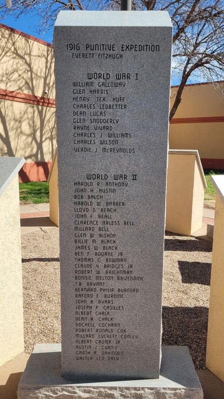
Dedicated to Curry County Veterans who served their country
World War I •
World War II •
Korea •
Vietnam •
Southwest Asia
1st Panel
1916 Punitive Expedition
Everett Fitzhugh
World War I
William Galloway . . . — — Map (db m269402) WM
Dedicated to Our Fallen Comrades Who Perished in the F-111 Defending Our Freedom
Maj Herbert F. Brightwell •
Mr Ralph H. Donnell •
Mr Charles E. Wangeman •
Maj Henry McCann •
Capt Dennis Graham •
Cmdr David L. Cooley USN •
Lt Col . . . — — Map (db m269405) WM
"Dedicated to the F-111 aircrews who gave their lives in defense of our nations freedom" F-111D 68-0140
Aircraft 68-0140 was the 56th of 96 F-111D Models produced by General Dynamics Corp. Ft. Worth, Texas. It was the 67th "D" Model . . . — — Map (db m269408) WM
Clovis schools were segregated when Ida O. Jackson arrived from Texas in 1926 to teach African-American youth. Starting with two students in Bethlehem Baptist Church, she encouraged early education and by 1935 taught 35 students in a one-room . . . — — Map (db m246804) HM
The African-American Community of
Clovis started its first school, Lincoln-
Jackson, in 1924 with two students. In 1926,
the school was named for Ida Jackson, a
favorite teacher, and Abraham Lincoln.
By 1954, K-12 enrollment had reached . . . — — Map (db m300920) HM
In honor of veterans of World War II from Curry County, New Mexico, their grateful fellow citizens contributed substantially to this library as a living memorial
1941-1945 — — Map (db m269401) WM
In honor of the Naval Service Veterans of Clovis and Curry County for their dedication and service to our great nation.
With grateful thanks to the Naval History & Heritage Command for the loan of this naval anchor, the State of New Mexico, . . . — — Map (db m269404) WM
At thirteen, Norman began cutting records in his father's filling station. With money earned from the Norman Petty Trio's "Mood Indigo", Petty converted a family grocery store next door into a modern recording studio where he experimented with echo . . . — — Map (db m269413) HM
At thirteen, Norman began cutting records in
his fathers filling station. With money earned
from the Norman Petty Trio's "mood Indigo",
Petty converted a family grocery store next
door into a modern recording studio where
he experimented with . . . — — Map (db m160369) HM
Back Panel In honored tribute to the brave men and women of the village of Melrose who served our country
Front Panel
Honored Veterans
WWI
Paulk, Jack •
Richards, Claude •
Smith, Claude
WWII . . . — — Map (db m269417) WM
Estella García. Estella García taught colcha embroidery at Melrose, New Mexico, for the Federal Arts Program in the 1930s. Anglo and Hispana women in Garcia's class collaborated to design and produce embroidered theater curtains, wall . . . — — Map (db m73703) HM
The F-100 was fully operational from October 1957, to June 1972. The Super Saber was first delivered to the Tactical Air Command (TAC) in September 1954. This aircraft belonged to the last operational F-100 unit in TAC, the 524th Tactical Fighter . . . — — Map (db m269414) HM WM
Nomadic Indians and countless buffalo herds dominated this vast plain when the Vásquez de Coronado expedition explored it in 1541. Later it was the focus of Comanchero activity, and in the 19th century it became a center for cattle ranching. The . . . — — Map (db m73716) HM
During the 1700s and early 1800s, Comanche Indian buffalo hunters used trails that passed near here. In 1907 the Santa Fe Railroad established Clovis to serve as the eastern terminal of the Belen Cutoff, which would connect with the transcontinental . . . — — Map (db m145061) HM
He was known by many names, William Henry McCarthy, William H. Bonney, but he was best known as "Billy the Kid." Born in New York City in 1859, he would find infamy in the old west as a hired gun, outlaw and other wise stone-cold killer. His mother . . . — — Map (db m269527) HM
• Billy the Kids tombstone was stolen in 1951. Its location was a mystery for twenty-six years until 1976 when it was recovered in Granbury, Texas, by Joe Bowlin.
• The tombstone was stolen again on Feb. 8, 1981 and recovered four days later . . . — — Map (db m269530) HM
The U.S. Army established Fort Sumner in 1862 as a supply and control point for the Bosque Redondo Indian Reservation. About 10,000 Navajo were forcibly relocated from the Four-Corners Region during the tragic march known as the Long Walk. About 500 . . . — — Map (db m73718) HM
You are entering the grounds of historic Fort Sumner, headquarters of the Bosque Redondo Indian Reservation.
Over 400 Mescalero Apache and 7,000 Navajo were held here as prisoners of war. The museum tells their stories. — — Map (db m280103) HM
Why Here?
General James H. Carleton, commanding the Military Department of New Mexico, ordered the establishment of Fort Sumner in late 1862. Carleton and others mistakenly believed the Pecos River and the land surrounding Fort Sumner would . . . — — Map (db m269513) HM
A New Community
Following the disastrous failure of the U.S. Government's Bosque Redondo experiment, the land set aside as reservation returned to the public domain. The Army sold the fort buildings and other improvements to the famous . . . — — Map (db m269514) HM
Charlie Bowdre fought alongside Billy the Kid in the Lincoln County War. After losing the war, both he and the Kid retreated to Fort Sumner, NM, where Bowdre worked as a cowboy and was also suspect in Billy's outlaw endeavors. In December 1880 the . . . — — Map (db m269534) HM
A Navajo woman born in Canyon de Chelly, AZ, Deluvina was taken as a slave during an Apache raid when she was a child. Later adopted by Lucien Maxwell of Fort Sumner, she was a loyal servant of the Maxwell family.
She was present in Fort . . . — — Map (db m269544) HM
Population 1,250 – Elevation 4,028 ft.
Named for the fort built in 1862 to guard the Bosque Redondo Indian Reservation, the town of Fort Sumner grew out of settlements clustering around the Maxwell family properties. It moved to its present . . . — — Map (db m73721) HM
Population 1,250 – Elevation 4,028 ft.
Named for the fort built in 1862 to guard the Bosque Redondo Indian Reservation, the town of Fort Sumner grew out of settlements clustering around the Maxwell family properties. It moved to its . . . — — Map (db m73722) HM
Named for the fort built in 1862 to guard the Bosque Redondo Indian Reservation, the town of Fort Sumner grew out of settlements clustering around the Maxwell family properties. It moved to its present site with the construction of the Belén Cutoff . . . — — Map (db m270116) HM
Fort Sumner was established in 1862 to control the Diné (Navajo) and N'de (Mescalero Apache) who were forcibly marched from their homelands and interned at the Bosque Redondo Reservation. Conditions here caused great suffering. The N'de escaped in . . . — — Map (db m270115) HM
It is said that... While drunk one night, Grant had the misfortune of getting on the wrong side of "Billy the Kid" at Beaver Smith's saloon in Ft. Sumner, NM. After a heated discussion, Grant bet Billy $25 that he would kill a man first. Billy . . . — — Map (db m269524) HM
A native of Kaskaskia, Ill, a fur trader and trapper who by industry, good fortune and trading became sole owner in 1864 of the largest single tract of land owned by any one individual in the United States.
Maxwell founded the First National . . . — — Map (db m73719) HM
Fort Sumner was established in 1862 to guard the Navajo and Apaches on the Bosque Redondo reservation. It was discontinued as a military post in 1868 and the buildings and site sold to Lucien B. Maxwell. William "Billy the Kid" Bonney was killed . . . — — Map (db m73713) HM
Tom O'Folliard was the best friend of outlaw William Bonney (Billy the Kid). Both men were members of the Regulators during the Lincoln County War. O'Folliard was shot in the shoulder during the famous Five-Day Battle in Lincoln. After the war . . . — — Map (db m269532) HM
Welcome to the cemetery at Historic Fort Sumner. The U.S. Army established this post cemetery in 1863, shortly after opening the nearby fort and the Bosque Redondo Indian Reservation. Between 1863 and 1869, 22 soldiers and officers, along with . . . — — Map (db m269521) HM
William "Billy the Kid" Bonney Grave 1859-1881
Henry McCarty is better known by his alias, William "Billy the Kid" Bonney. His family moved to the New Mexico territory in 1873. Bonney was charged with numerous thefts and involved in nine . . . — — Map (db m270111) HM
Lake Sumner was originally named Alamogordo Lake after Alamogordo Creek. The lake and surrounding land became a state park in 1960. In 1974, the lake and state park were renamed Sumner in honor of Colonial Edmond Vose Sumner who in the mid 19th . . . — — Map (db m245417) HM
At noon on November 30, 1944, a World War II supply train hauling 165 five-hundred-pound bombs headed for the Pacific Theater derailed in Tolar. The train caught fire and the bombs exploded. The blast, which leveled nearly every building in town, . . . — — Map (db m269512) HM
At four, Manuelita de Atocha (Mela) Lucero Leger read Spanish language newspapers to her blind grandfather in Colonias. Although New Mexico's constitution protects Spanish-speaking students, school children were often punished for speaking . . . — — Map (db m45893) HM
By 1700 the Comanches had acquired the horse and began moving into this area. They drove out the Jicarilla Apaches, and their raids on New Mexico's eastern frontier posed a threat to Indian, Spanish and Anglo settlements for over a century. The . . . — — Map (db m93763) HM
Rising above these red-earth lowlands to the south is the Llano Estacado or Staked Plain, a high plateau covering some 32,000 square miles in eastern New Mexico and adjacent areas in Texas. Topographically, it is one of the flattest areas in the . . . — — Map (db m93197) HM
Grassy plains meet pine dotted uplands in this transition from Great Plains to Basin and Range provinces. Plains to the east are capped by caliche, sand, and gravel which are deeply eroded into the underlying bedrock in places. To the west, faulting . . . — — Map (db m91047) HM
Built in 1917-1919, this
Craftsman/Bungalow residence
with hardwood interior detailing,
unique in this area, was a center
for entertaining U.S. Senators
and Congressmen.
Site No. 848
A Registered Cultural Property
State of New . . . — — Map (db m236786) HM
Originally La Fiesta Café, Joseph's was opened in 1956. It has fed locals and tourists along Route 66 through three generations of Campos.
Recognized by Hampton Hotels Save-a-Landmark program as a site worth seeing — — Map (db m189205) HM
Established by the early 1860s, Puerto de Luna is one of southeast New Mexico’s oldest permanent settlements. An important farming and ranching center, the town was the Guadalupe County seat from 1891 until 1903. A strong oral tradition maintains . . . — — Map (db m45906) HM
The Spanish explorer Antonio de Espejo passed through this area in 1583, as did Gaspar Castano de Sosa in 1590. Santa Rosa, the Guadalupe County seat, was laid out on the ranch of Celso Baca y Baca, a politician and rancher in the late 1800s. It was . . . — — Map (db m45894) HM
The Spanish explorer Antonio de Espejo passed through this area in 1583, as did Gaspar Castaño de Sosa in 1590. Santa Rosa, the Guadalupe County seat, was laid out on the ranch of Celso Baca y Baca, a politician and rancher in the late 1800s. It was . . . — — Map (db m45895) HM
The Spanish explorer Antonio de Espejo passed through this area in 1583, as did Gaspar Castaño de Sosa in 1590. Santa Rosa, the Guadalupe County seat, was laid out on the ranch of Celso Baca y Baca, a politician and rancher in the late 1800s. It was . . . — — Map (db m91041) HM
Pronghorn antelope may be seen grazing near this reservoir on the Pecos River, at the edge of the Llano Estacado - the famed "Staked Plains." The park offers water sports; fishing for catfish, bass, and walleyes; camping/picnicking sites, a . . . — — Map (db m280148)
Established in 1959, the Silver Moon Café has gained legendary status as a Route 66 landmark eatery. It is world renowned for its signature Mexican dishes and American favorites. The restaurant has been featured in a number of print and TV news . . . — — Map (db m183588) HM
To give gold-seekers another route to California, Capt. Randolph B. Marcy and Lt. James H. Simpson opened a wagon road from Arkansas to New Mexico in 1849. Marcy’s Road, although very popular with the Forty-Niners, still was never as well-traveled . . . — — Map (db m91044) HM
Vaughn, a division point in the transcontinental railway system, is located along the route of the Stinson cattle trail. In 1882, Jim Stinson, manager of the New Mexico Land and Livestock Co., drove 20,000 cattle in eight separate herds along this . . . — — Map (db m47146) HM
Flowing out of the Rockies, the Canadian River has cut a gorge 600 feet deep through sedimentary strata of the High Plains. Rim elevation is 5,400 feet. — — Map (db m62852) HM
The site of one of New Mexico's most spectacular horticultural enterprises, the Orchard Ranch, established by Melvin W. Mills of Springer and notable for its skillfully engineered irrigation system. The ranch cultivated 12 miles of land along the . . . — — Map (db m63777) HM
Offering the best walleye fishing in New Mexico, this reservoir on the Canadian River also provides good fishing for both white and largemouth bass, channel cat fish and crappie. Park facilities include camping, picnicking sites, a playground, boat . . . — — Map (db m280179) HM
The area is rich in prehistoric evidence, and home of the buffalo and Plains Indians. Explored by the early Spanish, the area was settled when the Rock Island Railroad was built thru in 1901.
The brick building, built in 1921, was home for a fine . . . — — Map (db m78866) HM
Founded in 1906 and at one time had a couple dozen buildings with all types of business found in early western towns including a newspaper called Obar Progress.
A partial list of the several hundred pioneer families who homesteaded in the Obar . . . — — Map (db m78867) HM
Sediments shed from the rising mountains to the west formed the Llano Estacado, later to be bypassed by streams such as the Pecos and Canadian Rivers and left standing in bold relief with a relatively level, uneroded caprock surface. Croplands on . . . — — Map (db m91040) HM
The Motel Safari opened in 1959, during the height of the Mother Road's popularity.
Developer Chester Dohrer employed an architectural style known as 'Doo Wop' or 'Googie' to achieve a unique look that immediately set the Safari apart from . . . — — Map (db m183590) HM
The last of the train robbers, Black Jack Ketchum, who terrorized the railroads in the 1880's killed two men near this spot and hid out in a cave near Saddleback Mesa to the Southwest. The swarthy bandit was wounded in his last robbery and hanged in . . . — — Map (db m280180) HM
By 1700 the Comanches had acquired the horse and began moving into this area. They drove out the Jicarilla Apaches, and their raids on New Mexico's eastern frontier posed a threat to Indian, Spanish and Anglo settlements for over a century. The . . . — — Map (db m280181) HM
Built under Brigadier General James H. Carleton. First Post Commander Captain Peter W.L. Plympton with Company F, 7th U.S. Infantry and Company 1st New Mexico Volunteer Cavalry. Named after Captain George N. Bascom, 16th U.S. Infantry. Officers . . . — — Map (db m63510)
Fort Bascom was built to protect this area from Comanches. In 1864, Kit Carson led a campaign against the Comanches, as did General Philip Sheridan in 1868. The fort was also established to control the Comancheros, New Mexicans involved in illegal . . . — — Map (db m93198) HM
This area was troubled by both Comanches and Comancheros, New Mexicans who traded illegally with the Indians, until the military campaigns of 1874. With the coming of the railroad in 1898, the small community of Liberty, eight miles to the north, . . . — — Map (db m78868) HM
This area was troubled by both Comanches and Comancheros, New Mexicans who traded illegally with the Indians, until the military campaigns of 1874. With the coming of the railroad in 1898, the small community of Liberty, eight miles to the north, . . . — — Map (db m78888) HM
Tucumcari was founded in 1901,
the Chicago, Rock Island and
Pacific Railroad built a
construction camp. Originally
called Ragtown, the camp
became known as Six-Shooter
Siding due to numerous
gunfights. It was renamed
Tucumcari in 1908. — — Map (db m274587) HM
Tucumcari Mountain has long been a landmark for travelers along the Canadian River. Pathfinder Pedro Vial mentioned it in 1793, while opening a trail between Santa Fe and St. Louis. In order to find the best route from Arkansas to California, Capt. . . . — — Map (db m119938) HM
Tucumcari Mountain has long been a landmark for travelers along the Canadian River. Pathfinder Pedro Vial mentioned it in 1793, while opening a trail between Santa Fe and St. Louis. In order to find the best route from Arkansas to California, Capt. . . . — — Map (db m119940) HM
Tucumcari Mountain has long been a landmark for travelers along the Canadian River. Pedro Vial mentioned it in 1793, while opening a trail between Santa Fe and St. Louis. In order to find the best route from Arkansas to California, Capt. Randolph . . . — — Map (db m280182) HM
Born in Bavaria and widowed in Las Vegas, New Mexico, Yetta ran the family store and raised four children alone. She later moved to La Cinta on the Canadian River where she opened another store, became postmistress, started a bank and operated a . . . — — Map (db m78891) HM
Near this spot in the summer of 1877, soldiers
of Troop A of the U.S. Tenth Cavalry endured
substantial hardship. During an attempt to force
a band of Kwahada Comanche warriors back
to their reservation in Oklahoma, the soldiers
became lost, . . . — — Map (db m300921) HM
Blackwater Draw consists of several important archaeological sites that have yielded much information about the big-game hunting way of life. Some of the animals that were hunted, like the mammoth, are long extinct. Eastern New Mexico University's . . . — — Map (db m56114) HM
This university was established at Portales in 1927 by the State Legislature as the Eastern New Mexico Normal School. It opened for the 1934-35 School year with 274 students. Originally established to train teachers for rural schools, Eastern now . . . — — Map (db m56118) HM
Portales derives its name from the porch-like appearance of a cave entrance at nearby Portales Springs. It developed as a major peanut producing region in the early twentieth century, after the Pecos Valley Railroad opened the area for commercial . . . — — Map (db m56117) HM
Portales derives its name from the porch-like appearance of a cave entrance at nearby Portales Springs. It developed as a major peanut producing region in the early twentieth century, after the Pecos Valley Railroad opened the area for commercial . . . — — Map (db m56120) HM
In 1879, the first ranch was established in the area. The Pecos
Valley and Northeastern Railroad (known locally as the Pea Vine)
did not reach this box tent establishment until 1898, but was
instrumental to the founding of Portales. In 1899 the . . . — — Map (db m298145) HM
Rose Powers White worked tirelessly to compile histories of early pioneers of southeastern New Mexico. She published numerous articles and was frequently asked to lecture to organizations and school groups. She served as president of the New . . . — — Map (db m56113) HM
Founded 1939
History and Anthropology of Roosevelt County
Open
Tue.-Fri. 10:00 to 4:00
Sat. 12:00 to 5:00
Closed Sun. & Mon.
Admission Free — — Map (db m300924) HM
Cinder cones experience a single eruptive period, and then die. Several explosive eruptions created Capulin Volcano, during a period as short as one year or as long as nine or more years. Today Capulin Volcano is extinct.
Volcanic ash, . . . — — Map (db m89235) HM
An outstanding example of an extinct volcanic cinder cone, Capulin Volcano was formed as early as 10,000 years ago. In cinder cones, lava pours from cracks in the base rather than over the top. Capulin itself was the escape hatch for gases that blew . . . — — Map (db m88756) HM
An outstanding example of an extinct volcanic cinder cone, Capulin Volcano was formed as early as 10,000 years ago. In cinder cones, lava pours from cracks in the base rather than over the top. Capulin itself was the escape hatch for gases that blew . . . — — Map (db m88759) HM
The shortgrass prairie and mountain forest meet here in the high plains of northeastern New Mexico. This transition between two ecosystems provides habitat for many different plants and animals. The shortgrass prairie is the western limit of the . . . — — Map (db m89230) HM
The late 1800s were a time of homesteading and private acquisition of public lands. Conservationists began working to preserve some public lands like Yellowstone and Yosemite. In 1891, the General Land Office of the Department of the Interior . . . — — Map (db m89224) HM
This region of volcanic activity is the Raton-Clayton Volcanic Field. It has been active periodically, beginning at the western edge of the field with the Raton Phase from 9 to 3 million years ago. The Capulin Phase began about 1 million years ago . . . — — Map (db m89228) HM
Capulin Volcano directly in front of you is a dramatic example of the volcanic processes that shaped northeastern New Mexico. Capulin Volcano National Monument preserves this classic cinder cone. About 60,000 years ago thunderous explosions sent . . . — — Map (db m89223) HM
Thomas "Black Jack" Ketchum, leader of a notorious band of train robbers, was wounded in August 1899 while trying to rob a train near Folsom. He surrendered the next day. He was tried and convicted under a law making train robbery a capital offense, . . . — — Map (db m55462) HM
Trade caravans and homesteaders traveling the Cimarron Cutoff of the Santa Fe Trail passed near here. Clayton was founded in 1887 and named for the son of cattleman and ex-Senator Stephen W. Dorsey, one of its developers. It became a major livestock . . . — — Map (db m55209) HM
Trade caravans and homesteaders traveling the Cimarron Cutoff of the Santa Fe Trail passed near here. Clayton was founded in 1887 and named for the son of cattleman and ex-Senator Stephen W. Dorsey, one of its developers. It became a major livestock . . . — — Map (db m55218) HM
One of the best dinosaur track sites in the world can be viewed at Clayton Lake State Park. More than 500 fossilized footprints, made by at least eight kinds of dinosaurs, are visible on the lake’s spillway. These tracks were embedded in the mud . . . — — Map (db m55233) HM
This structure has been placed on the National Register of Historic Places by the United States Department of Interior. Site No. 220 A Registered Cultural Property State of New Mexico — — Map (db m292888) HM
Built 1919, this building served as a church from 1920 through 1967. It is now the Herzstein Memorial Museum. Site No. 1508 A Registered Cultural Property State of New Mexico — — Map (db m292897) HM
“The stone markers in the adjoining panels were part of the Herzstein’s Store, a building of Pueblo Indian architecture which was on this site from 1931 to 1971. Herzstein’s opened in 1895 in Clayton and was a significant factor in the growth of . . . — — Map (db m292895) HM
These two striking mounds were the first features to become visible to Santa Fe Trail traffic crossing into New Mexico from Oklahoma, and so became important landmarks for caravans.
From here, traffic on this major 19th century commercial route . . . — — Map (db m55217) HM
These two striking mounds were the first features to become visible to Santa Fe Trail traffic crossing into New Mexico from Oklahoma, and so became important landmarks for caravans.
From here, traffic on this major 19th century commercial route . . . — — Map (db m55219) HM
William Becknell, the first Santa Fe Trail trader, entered Santa Fe in 1821 after Mexico became independent from Spain and opened its frontier to foreign traders. The Mountain Branch over Raton Pass divided here. One fork turned to Cimarron, . . . — — Map (db m55235) HM
Santa Fe Trail Cimarron Cutoff
The Santa Fe Trail was the major trade route between New Mexico and Missouri from 1821 until arrival of the railroad in 1880. The Cimarron Cutoff, a major branch of the Trail, passed through this portion of . . . — — Map (db m55236) HM
Has been placed on the National Register of Historic Places by the National Park Service United States Department of the Interior — — Map (db m292894) HM
Near where you are standing was
one of the great overland trade
routes of the 19th century.
Connecting Franklin, Missouri,
with Santa Fe, New Mexico, the
trail ran 900 miles through rough
terrain hostile to all but the hardiest
traders set . . . — — Map (db m162262) HM
Against this wall Thomas Edward "Black Jack" Ketchum swung into eternity April 26, 1901 Desperado Train Robber “A good cowboy that went wrong” — — Map (db m288741) HM
Largest extinct volcano in northeastern New Mexico, Sierra Grande rises to an elevation of 8,720 feet, one of many volcanos, cinder cones, and flows that cover more than 1,000 square miles of area in northeastern New Mexico and southeastern . . . — — Map (db m88754) HM
Largest extinct volcano in northeastern New Mexico, Sierra Grande rises to an elevation of 8,720 feet, one of many volcanos, cinder cones, and flows that cover more than 1,000 square miles of area in northeastern New Mexico and southeastern Colorado . . . — — Map (db m88761) HM
103 entries matched your criteria. The first 100 are listed above. The final 3 ⊳