By Dale K. Benington, August 9, 2010
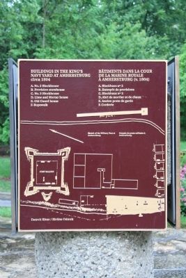
Buildings in the King's Navy Yard at Amherstburg Marker
| Near Dalhousie Street west of Rankin Avenue. |
| On Dalhousie Street, on the left when traveling south. |
| Near Laird Avenue South just south of Elm Avenue, on the right when traveling south. |
| Near Laird Avenue South just south of Elm Avenue, on the right when traveling south. |
| On Front Road South (County Route 20) south of Dalhousie Street, on the left when traveling south. |
| On Front Road South (County Route 20) close to Dalhousie Street, on the left when traveling south. |
| Near Laird Avenue South just south of Elm Avenue, on the right when traveling south. |
| Near Laird Avenue South just south of Elm Avenue, on the right when traveling south. |
| On Laird Avenue South south of Elm Avenue, on the right when traveling south. |
| Near Laird Avenue South just south of Elm Avenue, on the right when traveling south. |
| Near Laird Avenue South just south of Elm Avenue, on the right when traveling south. |
| Near Laird Avenue South just south of Elm Avenue, on the right when traveling south. |
| On Ramsay Street south of Gore Street, on the left when traveling south. |
| Near Laird Avenue South close to Elm Avenue, on the right when traveling south. |
| Near Laird Avenue South just south of Elm Avenue, on the right when traveling south. |
| Near Laird Avenue South just south of Elm Avenue, on the right when traveling south. |
| Near Laird Avenue South just south of Elm Avenue, on the right when traveling south. |
| On Front Street South (Provincial Highway 20) south of Bingham Road, on the left when traveling south. |
| On Front Street North (Provincial Highway 20) north of North Side Road, on the right when traveling south. |
| Near Laird Avenue South just south of Elm Avenue, on the right when traveling south. |
| On Laird Avenue South south of Elm Avenue, on the right when traveling south. |
| Near Dalhousie Street west of Rankin Avenue. |
| Near Dalhousie Street west of Rankin Avenue. |
| On Dalhousie Street north of Richmond Street, on the right when traveling south. |
| Near Laird Avenue South just south of Elm Avenue, on the right when traveling south. |
| On Front Road North north of County Route 10, on the right when traveling south. |
| Near Lower Thames Lane just north of Harbour Drive when traveling north. |
| On Banwell Rd, 1.4 kilometers north of County Rd 42, on the left when traveling north. |
| On Riverside Drive West at Huron Church Road on Riverside Drive West. |
| On Sandwich Street West just north of Brock Street, on the right when traveling north. |
| On Ouellette Avenue at Viale Udine, on the right when traveling north on Ouellette Avenue. |
| On Riverside Drive East west of Walker Road, on the left when traveling east. |
| On 2072 Riverside Drive East west of Walker Road, on the left when traveling east. |
| On Riverside Drive West at Huron Church Road, on the right when traveling south on Riverside Drive West. |
| On Riverside Drive West north of Askin Avenue, on the right when traveling west. |
| On University Avenue East at Freedom Way, on the right when traveling east on University Avenue East. |
| On Riverside Drive East at Riverside Avenue, on the right when traveling west on Riverside Drive East. |
| On 254 Pitt Street West, 0.2 kilometers east of Dougall Avenue, on the right when traveling west. |
| On Sandwich Street at Ojibway Parkway, on the right when traveling south on Sandwich Street. |
| Near Riverside Drive West north of Ferry Street. |
| On Pitt Street West west of Ferry Street, on the right when traveling west. |
| On Riverside Drive E at Gayeau Street on Riverside Drive E. |
| On Ouellette Avenue at Viale Udine, on the right when traveling north on Ouellette Avenue. |
| On Riverside Drive East close to Pillette Road. |
| On Pitt Street East east of Goyeau Street. |
| On Ferry Street at Chatham Street West, on the left when traveling north on Ferry Street. |