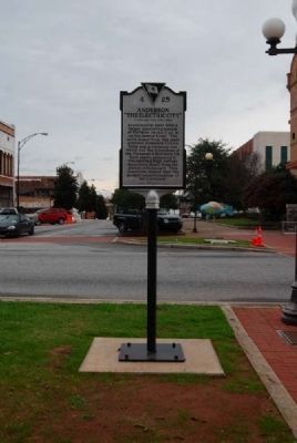
On South Main Street (State Highway 28) at West Whitner Street (State Highway 24), on the right when traveling west on South Main Street.
Front:
Anderson was dubbed "The Electric City" in 1895 when William C. Whitner, an engineer and native of Anderson, built a hydroelectric power plant which was the first in the South to transmit electricity over long distances. The . . . — — Map (db m10693) HM
This area was a hub of African-American life from the late-19th to mid-20th centuries. Anderson County Training School, built ca. 1922 as a Rosenwald school, closed in 1954 under the equalization program for black and white schools. It burned in . . . — — Map (db m54824) HM
On Holmes Street, on the left when traveling south.
Belton
The Tennis Capital of South Carolina
Tennis Anyone?
Long know as the Tennis Capital of South Carolina, Belton's tennis history can be traced back over 110 years. An 1892 edition of the Anderson Intelligencer . . . — — Map (db m35564) HM
On North McDuffie Street at Whitner Street, on the right when traveling south on North McDuffie Street.
Half mile West on Seneca River
the Portman Shoals Power Plant,
built by William C. Whitner,
began in 1897 the transmission
of high-voltage electricity over
the longest lines then in use for
that purpose in the United States.
The . . . — — Map (db m10696) HM
This is Anderson County's second court house. It stands on the site of the first small brick court house where the first court session in Anderson was held on the third Monday in October, 1820. The present building of pronounced Victorian . . . — — Map (db m10692) HM
On North Main Street (U.S. 76) at South Carolina Highway 247, on the right when traveling south on North Main Street.
Replacing the wooden structure located across the street that had served the Belton Community since 1853, the brick Southern & Blue Ridge Combined Railway Depot was designed in 1907 and completed by 1910. In the heyday of passenger and freight train . . . — — Map (db m31012) HM
On East Benson Street at South Main Street (South Carolina Highway 28), on the right when traveling east on East Benson Street.
This building was erected as the home of the Bank of Anderson, an outgrowth of the Anderson National Bank founded in 1872 with Col. Joseph Newton Brown as president. The early bank was located on the west side of the square. It was the second . . . — — Map (db m21221) HM
On East Front Street at East Broad Street, on the left when traveling south on East Front Street.
A "Great" Town
In 1886, the Savannah Valley railroad made its way into lower Anderson County. The depot town of Cook's Station was named for Dr. Augustus G. Cook, a local physician and businessman. The town was later called Iva in honor of . . . — — Map (db m43944) HM
On West Oak Highway (State Highway 24) at Townville School Road, on the right when traveling east on West Oak Highway.
[Front]
This church, founded as Nazareth on the Beaverdam Presbyterian Church, was established in 1803. It met in members’ homes until they paid $1.50 for a half-acre tract and built a small frame church 2.5 mi. E. The founders’ cemetery . . . — — Map (db m39349) HM
On Broadway Lake Road at Belton Highway (U.S. 178), on the right when traveling east on Broadway Lake Road.
2.9 miles south on Rocky River
Anderson Water, Light, & Power Co.,
organized in 1894 by
William C. Whitner,
was successful the next year
in transmitting electricity over
the distance of six miles
to Anderson.
This achievement was a . . . — — Map (db m88441) HM
On Three and Twenty Road (State Highway 485), on the left when traveling south.
This land, Cherokee territory until 1777, became the final resting place after the American Revolution for early pioneers who settled the area. A number of soldiers of the Revolution are buried here including Robert Pickens, who served in the . . . — — Map (db m9087) HM
This church, the first Associate Reformed Presbyterian congregation in what is now Anderson County, was organized about 1790 about 1 1/2 mi. SW of this site. Rev. Robert Irwin, its first regular minister, served from 1803 until his death in . . . — — Map (db m11747) HM
On East Queen Street, on the left when traveling east.
Located in the center of Historic Pendleton (1790), the building now housing the Pendleton District Commission was constructed in 1850 as a general store for Jesse Lewis. The business first came into the Hunter family in 1870 when it became . . . — — Map (db m13903) HM
On April 8, 1790, the Justices of the Peace for Pendleton County purchased this land to establish the courthouse town of Pendleton. Once Cherokee Indian land, the town became the judicial, social and commercial center for what now are Anderson, . . . — — Map (db m9614) HM
Memories of the Plantation Era -- Owners and Tenants
Owners
Charles Cotesworth Pinckney, elected Lieutenant Governor of South Carolina in 1822, made Woodburn Historic House his summer home around 1830. A graduate of Harvard . . . — — Map (db m15361) HM
On History Lane, on the right when traveling west.
Some 200 yards west of here stands Woodburn, built by S.C. Lieutenant Governor Charles Cotesworth Pinckney by 1832. Dr. John B. Adger, Presbyterian minister to Armenia, bought Woodburn in 1852; in 1881 Augustine T. Smythe began a model stock farm . . . — — Map (db m9588) HM
Sandy Springs Camp Ground: This Methodist camp ground named for the large spring nearby, dates to 1828, when a fifteen-acre site was purchased from Sampson Pope for $45. Early meetings were under a brush arbor until a central wooden shelter . . . — — Map (db m10785) HM
On Erwin Mill Road, on the left when traveling south.
Named in 1978
by Legislative Request
Honoring Him
for His Distinguished Service
Clerk of Court
Anderson County
1920-1932
Congressman
Third S.C. District
1933-1938
Trustee
University of South Carolina
1946-1950
. . . — — Map (db m15592) HM
On Interstate 85 south of South Carolina Highway 187.
Named in honor of
Wilton E. Hall
Publisher of
The Anderson Independent
and
Daily Mail
For his dedicated service
to Anderson County
and South Carolina — — Map (db m19493) HM
Near County Road 16, on the right when traveling east.
William A. Floyd, a man of vision, served Anderson County as the first African-American elected to the Anderson County Council. He touched the lives of many county residents in various ways, as a husband, father, teacher, coach, councilman, . . . — — Map (db m21328) HM
On North Shirley Ave west of Chiquola Avenue, on the left when traveling east.
[Front]:
Native American Trade and the "Honey Path"
Town historians long debated the origin of the unusual name "Honea Path." Some attribute it to settler William Honey, who purchased 200 acres northeast of town in 1788. Others say . . . — — Map (db m11252) HM
On West Main Street (State Highway 184) south of Austin Road, on the right when traveling south.
Dedicated to
Jane Byrd Wilson
Sept. 19,1939 - March 17, 2000
She worked to preserve the valuable
heritage of the Boonesborough Township — — Map (db m12103) HM
The first municipal airport in Anderson was just a grassy field located near where the Civic Center now stands. An historical marker notes the site where Amelia Earhart landed there on November 14, 1931.
In the early 1930s land was purchased . . . — — Map (db m53938) HM
On Old Greenville Highway (State Highway 88), on the left when traveling north.
This plantation on the old road to Pickensville has been the home of several prominent S.C. families. Many of its owners were members of the Pendleton Farmers Society, and during the nineteenth century, studies, experiments, and advances in . . . — — Map (db m9649) HM
This property was this site of a private residence as early as 1830's. In 1860, John Baylis Earle Sloan and his wife, Mollie Seaborne Sloan, established a home that became known as Tanglewood.
The columns and the ruins seen today are all . . . — — Map (db m16616) HM
Civic Center of Anderson - 1992
Chris Taylor Memorial Park - Dedicated 1998
Anderson Sports Complex - 1999
Anderson County Amphitheater - 1999
---------------------------
The Anderson County Sports and Entertainment Center . . . — — Map (db m36170) HM
On River Street (State Highway 247) at William Street on River Street.
This house, built c. 1854 for railroad supervisor Charles C. Chamberlain, was among the first homes constructed in Belton. When the town incorporated in 1855, Chamberlain was chosen as the first intendent. Ira Williams, who was active in . . . — — Map (db m87307) HM
This building served as a classroom and
dormitory for the former Union High School
Dedicated
"To The Glory of God"
July 20, 1991
The Reverend R.H. Mitchell -- Moderator at Renovation
Dr. Earl J. Mathis -- At Dedication
. . . — — Map (db m10752) HM
These extra wide porches, used for entertaining and enjoyment of he cool breezes, are called piazzas.
Seen on every piazza is a joggling board. In this country, the joggling board got its start in Charleston in 1803. By lightly bouncing, . . . — — Map (db m36306) HM
In Memory of
West Allen Williams
1804 - 1857
Founded Williamston
Donor of Spring
&
Park
-----
He said
This Water Shall by Forever
Free to All People — — Map (db m15795) HM
On West Main Street (State Highway 20) at Minor Street, on the left when traveling west on West Main Street.
"Embraced by the gratitude of an entire community and held in the love and admiration of a descended family, here rests the earthen tabernacles of our beloved founder, West Allen Williams, and family. Reverently moved from a forgotten cemetery a . . . — — Map (db m19714) HM
A South Carolina "Spa"
In 1852, following the discovery of a "healing" spring and the announcement that the railroad was going to be running through the area, the Town of Williamston was chartered. In time, lots were sold for houses to be . . . — — Map (db m15719) HM
Near West Main Street (State Highway 20) west of Minor Street.
This site and the one directly in front, Mineral Spring Park, which was donated by West Allen Williams in 1842, formed the nucleus for the new Town of Mineral Springs. In 1852, the town received its charter and the name was changed to Williamston . . . — — Map (db m19733) HM
Al Rosen is a native of Spartanburg, South Carolina and launched his career in 1950 by hitting a record 37 home runs in his rookie season. In 1953, he was unanimously voted the American League MVP after slugging 43 home runs and collecting 145 . . . — — Map (db m44084) HM
On South Main Street (South Carolina Route 28) south of East River Street (U.S. 178), on the right when traveling north.
Lynching in America
Between 1865 and 1950, at least 6,500 Black people were victims of lynchings in the United States. The abolition of chattel slavery was not accompanied by a commitment to equal rights or protection for Black people. In many . . . — — Map (db m237660) HM
On South Fant Street (State Highway 22) at East River Street (U.S. 76), on the right when traveling north on South Fant Street.
The location of the Anderson County Courthouse Annex on the corner of Fant and River Street has unique significance to Anderson's history. The site is the location of the 1865 federal encampment of the First Maine, 33rd Regiment, United States . . . — — Map (db m19838) HM
Named in honor
of a distinguished South Carolinian
in recognition of his
contributions
to the life and welfare
of this state and its citizens
Member, House of Representatives
1923-1924 Anderson County
1927-1930 Spartanburg . . . — — Map (db m9437) HM
This town, established in 1823, grew up around a store owned by Matthew Young (1803-1876), who was also postmaster 1831-43. It was first called Pressly's Station, for the post office opened in 1823 with David Pressly (1764-1834) as postmaster. The . . . — — Map (db m9397) HM
On South Manning Street at East Church Street, on the right when traveling south on South Manning Street.
This area planted in appreciation of
Mr. & Mrs. Wilton E. Hall
who since April 7, 1955 have contributed the facilities of radio stations WAIM & WCAC-FM to carry the ministry of this class to many thousands of people each Sunday morning. . . . — — Map (db m107216) HM
On East Whitner Street at North McDuffie Street, on the left when traveling east on East Whitner Street.
This building was erected as the home of G.F. Tolly Furniture Company, an outgrowth of Anderson's first cabinet shop established at this site by Ezekiel George. George F. Tolly entered business with Mr. George in 1856. Later married George's . . . — — Map (db m42725) HM
On West Whitner (State Highway 24) at Rose Hill Street, in the median on West Whitner.
The home of Judge Joseph N. Whitner, Anderson County's founding father, was located at the crest of this will. It stood until recent years when it was torn down. Judge Whitner was a South Carolina House of Representative from Pendleton District . . . — — Map (db m59361) HM
On Honea Path Highway (State Highway 252) at Barkers Creek Road, on the right when traveling south on Honea Path Highway.
Founded in 1821, this is the boyhood church and burial place of Olin D. Johnston. He was decorated for bravery in World War I, served in the S.C. House of Representatives, was twice Governor of S.C., in 1935-1939 and 1943-1945, and U.S. Senator from . . . — — Map (db m9335) HM
On North Shirley Avenue, on the left when traveling east.
Honea Path is the smallest town of the fourteen South Carolina communities with libraries funded by the Andrew Carnegie Foundation. Dr. John Wright, Mayor John Humbert, and Miss Jennie Erwin were leaders in obtaining the $5000 grant. The Honea . . . — — Map (db m10759) HM
On East Greenville Street at Hamilton Street, on the right when traveling west on East Greenville Street.
One of the oldest congregations and the mother of several others in Anderson County, it was organized in 1788 by Elder Moses Holland who served as pastor for 41 years. Dr. James Bruton Gambrell's mother was a member here. Soldiers of five wars . . . — — Map (db m8441) HM
On Main Street (State Highway 23) at Buncombe Street (U.S. 25), in the median on Main Street.
From its earliest history, Edgefield developed a reputation for violence. The bloody fighting of the Cherokee War of 1760 was followed by years of lawlessness and retribution during the Regulator period. period. During the American Revolution . . . — — Map (db m12534) HM
McDuffie was a strong advocate for the right of states to nullify or void acts of Congress within their borders. He developed and promoted the Nullification Theory & also served in the U.S. House and U.S. Senate. — — Map (db m12878) HM
On Main Street (U.S. 25) near Penn Street ( Highway 23), on the left when traveling west.
A tribute to the Governers
and Lieutenant Governors of South
Carolina who were
natives of or at one time
residents of Edgefield
District or County.
Governors
Andrew Pickens II (1816-18)
George McDuffie (1834-36)
Pierce Mason . . . — — Map (db m12645) HM
On Simpkins Street, on the right when traveling north.
Site of law offices of
Eldred Simkins
Congressman, Lt.-Governor
George McDuffie
Congressman, Governor,
U.S. Senator
Francis W. Pickens
Congressman, Governor,
Minister to Russia
Francis H. Wardlaw
Author of . . . — — Map (db m12657) HM
On State Highway 81 at Morrah Bridge Road (County Route 39), on the left when traveling north on State Highway 81.
Cherry Hill
Three miles southwest is "Cherry Hill," site of the home of George McDuffie (1790-1851), orator of nullification, member of the U.S. House of Representatives and the U.S. Senate, Major General of the State Militia, and Governor of . . . — — Map (db m11461) HM
The history of the brass cannon reflects the history of the Upstate of South Carolina during some of its most critical eras of conflict and change. The "Old Reformer" is also one of the oldest artifacts in the Upstate, since it arrived here . . . — — Map (db m42194) HM
On Kingsley Road, on the right when traveling north.
In Memory of
Henry Hitt Watkins
1866-1947
and
Maude Wakefield Watkins
1870-1963
This building was made possible through the generosity of Judge and Mrs. Watkins, the South Carolina Baptist Convention, and other dedicated friends . . . — — Map (db m19816) HM
On Camp Shop Road, on the right when traveling south.
Calhoun Falls State Recreation Area is located on Lake Russell, one of South Carolina's most popular and undeveloped large reservoirs. Lake Russell was created in 1984 and the 26,650-acre reservoir is surrounded by another 26,000 acres of public . . . — — Map (db m41448) HM
Anderson Presbyterian
Church Cemetery
Founded 1837
Land Given by
Judge J.N. Whitner
Used as the First
Public Burial Ground
For the Village — — Map (db m49496) HM
On West Reed Street, on the right when traveling west.
This is the first Negro church established in Anderson County. It was founded immediately after emancipation and incorporated in 1873. The Rev. Philip Morris was its first pastor. The present edifice, built in 1903, replaced two earlier frame . . . — — Map (db m60543) HM
On Cherry Street Extension (State Highway 115), on the right when traveling east.
Born in 1840, Colonel Simpson, lawyer, farmer, and legislator, drafted and executed Thomas Green Clemson's will, establishing Clemson Agricultural College in 1889. Simpson was first president of the college's board of trustees and once owned land . . . — — Map (db m9682) HM
On Ravenel Street west of Smythe Street, on the right when traveling west.
When Henry Pinckney Hammett (1822-1891), bought the property for his cotton mill, the area was named Piedmont, “Foot of the Mountains”. On April 30, 1873, subscribers met at Greenville to organize the Piedmont Manufacturing Company. Hammett was . . . — — Map (db m198835) HM
On Augusta Road (U.S. 1), on the right when traveling north.
Before the Revolution, two major trading routes came together near here. Branching to the west was the road to New Windsor Township on the Savannah. The Cherokee Path extended north to Ninety Six and south through Saxe Gotha Township on the . . . — — Map (db m43791) HM
On North Main Street (State Highway 184) at College Street (State Highway 20), on the left when traveling south on North Main Street.
As early as 1765 the site 6 miles NW known to the Indians as Yellow Water, where the Keowee Path crossed the Cherokee line, was called DeWitt's Corner. In 1777 a treaty between S.C. and the Cherokee Indians was signed there. The present town was . . . — — Map (db m10602) HM
On Wade Hampton Blvd. (U.S. 29) near Baileyview Street, on the right when traveling east.
This marks the eastern boundary (the present Greenville-Spartanburg county line) between the Cherokee Nation and the province of South Carolina from the end of the Cherokee War (1759-61) until 1777. In that year, the Treaty of DeWitt's Corner . . . — — Map (db m11264) HM
On East River Street (U.S. 76) near South McDuffie Street, on the left when traveling east.
Organized in 1828, this
was the first church in
Anderson. A log meeting
house built in 1830 on
West Benson Street served
the church until 1858
when a frame building
was erected on this site.
A brick church replaced
it in 1888. The . . . — — Map (db m10733) HM
On South McDuffie Street at East Reed Street, on the left when traveling south on South McDuffie Street.
Front
This Parish, organized in 1851 with the Rev. Benjamin Webb as its first vicar, grew out of occasional Episcopal services held in Anderson as early as 1844. The first church here, a frame Carpenter Gothic building, was completed in . . . — — Map (db m10417) HM
Born August 29, 1852
Died February 26, 1905
----------
Founder and President
Orr Cotton Mills
----------
Honest and Fearless in the
Discharge of Every Duty.
Rest in Peace. — — Map (db m15269) HM
This building was donated to
Anderson College in 1914 by
Mr. Charles S. Sullivan, Sr.
to be used as the President's Home.
In 1965 it was renovated to serve
as the music building. — — Map (db m19804) HM
This structure once housed the Anderson County Airport's Weather Reporting Station. Located across the street where the Civic Center is now and constructed in 1931 at a cost between $5500 and $6000, this building was designed to provide shelter . . . — — Map (db m15327) HM
On Elberton Highway (State Highway 184) at Sam Turner Road, on the right when traveling west on Elberton Highway.
[Front]:
At this site once stood the town of Moffettsville, originating with the establishment of Moffett's Mills Post Office on February 16, 1818. By 1883, the town had a population of twenty-five with a physician and general store. . . . — — Map (db m23812) HM
On Fairplay Road near Rogers Farm Road, on the left when traveling south.
Nazareth on the Beaverdam Presbyterian Church. This is the first known site of Townville Presbyterian Church, founded in this area in 1803 as Nazareth on the Beaverdam Presbyterian Church. The church held its services at members' homes until . . . — — Map (db m10784) HM
[Front]:
This school, often called Retreat Colored School, was built in 1923 for the African-American students in and near Westminster. A two-room, two-teacher, elementary school, it was built by local builder William Walker Bearden of . . . — — Map (db m53235) HM
A memorial to the Memory of the law enforcement officers of Anderson County South Carolina who gave their lives in the line of duty. Their valor and sacrifice will be long remembered.
William Gibson Anderson Police Dept. . . . — — Map (db m11399) HM
Native son William Church Whitner developed the concept and spearheaded financing for the first hydroelectric plant to transmit power over a long distance in the South. On May 1, 1895, electricity travelled six miles from a generator at High . . . — — Map (db m10695) HM
On McGee Way near Campbell Street, on the left when traveling east.
The National Register
of Historic Places:
The Belton
Standpipe
Dedication Plaque:
The Belton Standpipe
Historical Landmark Built 1908, Restored 1990
Placed on the State and National Archive's Register 1987
Mayor . . . — — Map (db m31166) HM
Near Stumphouse Tunnel Road near State Highway 28, on the right when traveling west.
[Listed from north to south]
Oconee Located on the edge of the Blue Ridge Mountains, Oconee County is known for nature-based activities such as boating, birding, backpacking, and camping
Pickens Pickens County has many beautiful . . . — — Map (db m185421) HM
On East Benson Street west of South McDuffie Street, on the right when traveling east.
This is the second Masonic Temple to occupy this location. After its organization in 1848, Hiram Lodge No. 68 met in the second story of a store building on the east side of the square for several years. The first temple was erected at this . . . — — Map (db m38438) HM
On Mitchell Road at Highway 146, on the left when traveling north on Mitchell Road.
On this site stood the third building erected by Whitefield Baptist Church. The building was used by the Congregation for worship and fellowship until 1957.
Erected as a memorial to God's blessings by his people at this sacred place. — — Map (db m36637) HM
Thin black lines indicate changes in relevance. Between each pair of lines entries are ordered geographically but all have the same relevance.
* Inflectional forms of words are their plurals, singulars, and possessives as well as gramatical tenses and similar variations.