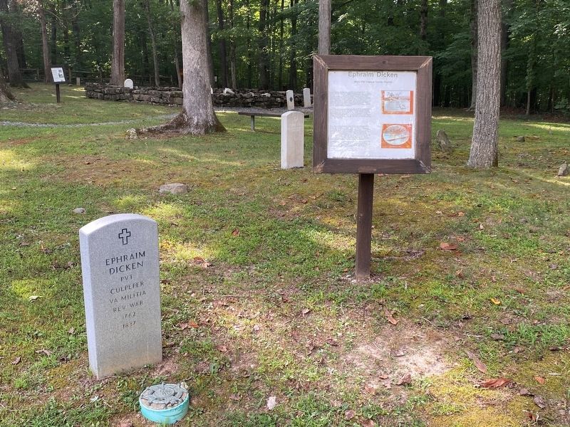
Ephraim Dicken was truly dedicated in his service to this country during the American Revolution. He was drafted into the Culpeper County Militia in 1781 and at the completion of that tour of duty he reenlisted as a substitute for Michael Wilhite; . . . — — Map (db m184059) HM
Music, reading and letter writing were all important pastimes for Civil War soldiers throughout their military service, and winter encampments offered extra time for these activities. While many soldiers kept to those pastimes, the town had a . . . — — Map (db m152629) HM
William Smith was born in King George County, Virginia. Arriving in Culpeper in 1818 as a young lawyer, he married Elizabeth Bell, the eldest daughter of a Culpeper merchant, and they had 11 children (4 died in infancy). In 1825, Smith built his . . . — — Map (db m282161) HM
In August of 1775 a Patriot army, commanded by Virginian George Washington, lay siege to the British army in Boston; and a company of Virginia riflemen, commanded by Daniel Morgan, had joined Washington. Virginia was in turmoil as well. Royal . . . — — Map (db m290484) HM
To the memory of A.P. Hill, Lt - Gen CSA
He was killed about 600 yards northwardly from this marker, being shot by a small band of stragglers from the Federal lines on the morning of April 2nd, 1865.
Erected by A.P. Hill Camp Sons of Confederate . . . — — Map (db m3595) HM
James Taylor Gaines (1776-1856) was an early Texas entrepreneur, adventurer, Republic of Texas congressman, and signee of the Texas Declaration of Independence. He was born in Culpeper County, Virginia, to Thomas and Susanah Strother Gaines. In . . . — — Map (db m290386) HM
Before the creation of independent African American churches throughout Virginia, the enslaved often attended church with their owners. Laws regulating African American gatherings and worship became increasingly strict in the 1830s following "Nat . . . — — Map (db m152626) HM
George Washington: Surveyor George Washington loved mathematics, a passion he put to work when he learned to survey land, a useful trade in colonial America. At the age of 15, his first surveying job was to map his brother's turnip . . . — — Map (db m14185) HM
[Front Plaque, Facing East.]
This monument was erected in the year 1909 in commemoration of the Battle of Point Pleasant, fought at the mouth of the Great Kanawha River, now in West Virginia, October 10, 1774. Between twelve hundred and . . . — — Map (db m22553) HM
By June 17, the Ninety Six garrison was low on food and ammunition. Cruger had expected a relief expedition from Charleston, but hope was turning into despair.
Suddenly, a farmer, casually riding near the American lines, spurred his gorse and . . . — — Map (db m11249) HM
This is the site of the first (1750-1808) and second (1809-1870) courthouses of Culpeper County, thought to be laid out by Culpeper County's first surveyor, George Washington in 1749. At the first courthouse, two important events occurred. On . . . — — Map (db m290912) HM
The land on which you are standing was known as Martin's Grist Mill, which was established around 1804 and operated by a series of owners throughout the 19th and early 20th centuries. The mill's prosperity was due in part its prime location . . . — — Map (db m295568) HM
After Confederate Gen. Robert E. Lee's stunning victory at Chancellorsville in May 1863, he led the Army of Northern Virginia west to the Shenandoah Valley, then north through central Maryland and across the Mason-Dixon Line into . . . — — Map (db m3753) HM
After Confederate Gen. Robert E. Lee's stunning victory at Chancellorsville in May 1863, he led the Army of Northern Virginia west to the Shenandoah Valley, then north through central Maryland and across the Mason-Dixon Line into . . . — — Map (db m3750) HM
Bourland Jolly (a.k.a. Boling Jolley) (1766-1844) born in Dinwiddie County, Virginia where he enlisted in the VA. Militia in 1781. He was enlisted by a Captain Connelly and later served under a Col. Lucas at the Siege of Yorktown. After . . . — — Map (db m292353) HM WM
Fauquier County. Area 686 Square Miles. Formed in 1759 from Prince William, and named for Francis Fauquier, Governor of Virginia, 1758-1768. Chief Justice John Marshall was born in this County.
Culpeper County. Area . . . — — Map (db m2209) HM
Founded in 1782, Stevensburg sits at the important intersection of the Old Carolina Road and Kirtley Road - the intersection where you now stand. The community is named for General Edward Stevens, a local Revolutionary War leader and state . . . — — Map (db m152625) HM
Early German Settlers
In 1714, the Governor of the Virginia Colony, Alexander Spotswood, seized an opportunity to establish a mining operation for iron ore and gold on the Western frontier along the Rapidan River. In his quest for skilled . . . — — Map (db m291576) HM
On the night of December 1, 1863, following its unsuccessful advance against Robert E. Lee's Confederate Army of Northern Virginia during the Mine Run Campaign, a cold and tired Army of the Potomac withdrew across the Rapidan River and returned to . . . — — Map (db m280448) HM
Following the end of the Civil War in 1865, Willis Madden, a free black man of color, built the African Ebenezer Church. The building had a half acre around it, and it was to be "Devoted to the preaching of the Gospel, as long as the colored . . . — — Map (db m185518) HM
"My command did not want to back out. We had backed out enough." —Gen. Nathaniel P. Banks, USA
"Banks is in our front and he is generally willing to fight. And he generally gets whipped." —Gen. Thomas "Stonewall" Jackson, CSA . . . — — Map (db m183957) HM
"My command did not want to back out. We had backed out enough." —Gen. Nathaniel P. Banks, USA
"Banks is in our front and he is generally willing to fight. And he generally gets whipped." —Gen. Thomas "Stonewall" . . . — — Map (db m290207) HM
Here Colonel Ulric Dahlgren, Union cavalryman, coming from the north, turned east. Dahlgren, who acted in concert with Kilpatrick, left Stevensburg, Culpeper County, on February 28, 1864, and moved toward the James River, tearing up the Virginia . . . — — Map (db m256995) HM
After the Battle of Antietam in September 1862, Gen. Robert E. Lee's Army of Northern Virginia escaped to Virginia. President Abraham Lincoln repeatedly urged Union Gen. George B. McClellan to pursue and attack. Following a plan that Lincoln . . . — — Map (db m42515) HM
After the Battle of Antietam in September 1862, Gen. Robert E. Lee's Army of Northern Virginia escaped to Virginia. President Abraham Lincoln repeatedly urged Union Gen. George B. McClellan to pursue and attack. Following a plan that . . . — — Map (db m42516) HM
Half a mile west, at the Rogers farm called Middle Hill, Gen. Robert E. Lee kept his headquarters from Dec. 1863 to May 1864. His Army of Northern Virginia, in winter camp, guarded the south side of the Rapidan River from the vicinity of Liberty . . . — — Map (db m4700) HM
After Confederate Gen. Robert E. Lee’s stunning victory at Chancellorsville in May 1863, he led the Army of Northern Virginia west to the Shenandoah Valley, then north through central Maryland and across the Mason-Dixon Line into . . . — — Map (db m50140) HM
After Confederate Gen. Robert E. Lee’s stunning victory at Chancellorsville in May 1863, he led the Army of Northern
Virginia west to the Shenandoah Valley, then north through central Maryland and across the Mason-Dixon Line into
Pennsylvania. . . . — — Map (db m77528) HM
On January 25, 1863, Union general Joseph "Fighting Joe" Hooker replaced Gen. Ambrose E. Burnside as the fifth commander of the demoralized eastern armies in less than two years. On taking charge of the Army of the Potomac, Hooker implemented . . . — — Map (db m154485) HM
On March 17, 1863, Union Gen. William W. Averell led 2,100 horsemen to the northern bank of the Rappahannock River at Kelly's Ford, four miles in front of you, under orders to "rout or destroy" Confederate Gen. Fitzhugh Lee and his cavalry command . . . — — Map (db m154487) HM
The Eckington School was built in 1895 as
a frame, one-room school for African American
students from the nearby communities of
Eckington and Poplar Ridge. The school
building is typical of the ungraded schools of
the 19th century that had all . . . — — Map (db m59522) HM
After the Battle of Antietam in September 1862, Gen. Robert E. Lee's Army of Northern Virginia escaped to Virginia. President Abraham Lincoln repeatedly urged Union Gen. George B. McClellan to pursue and attack. Following a plan that . . . — — Map (db m290438) HM
Union Maj. Gen. George G. Meade's Army of the Potomac crossed the Rapidan River on 26 Nov. 1863 in a last effort to strike Gen. Robert E. Lee's Confederate Army of Northern Virginia before winter. The next day, fighting erupted near here at . . . — — Map (db m294175) HM
Confederate Gen. Robert E. Lee’s Army of Northern Virginia crossed the Potomac River to Virginia and camped at Bunker Hill in the northern Shenandoah Valley after the September 17, 1862, Battle of Antietam. Union Gen. George B. McClellan and the . . . — — Map (db m64423) HM
Pioneer Baptist Minister
Born in Virginia
April 6, 1781 Died December 3, 1844
His Wife Patsy Dixon Parker
Born January 17, 1783 Died December 1, 1846 — — Map (db m245830) WM
Culpeper County. Area 284 square miles. Formed in 1748 from Orange, and named for Lord Culpeper, Governor of Virginia 1680–1683. The battle of Cedar Mountain, 1862, was fought in this county.
Rappahannock County. . . . — — Map (db m8293) HM
Seat of War
Railroads connecting Washington, D.C., and Richmond crossed Culpeper County, Virginia, so this area witnessed major Civil War battles. Both Union and Confederate armies occupied this area throughout the war. In 1861, the . . . — — Map (db m170182) HM
Culpeper County. Area 384 Square Miles. Formed in 1748 from Orange, and named for Lord Culpeper, Governor of Virginia, 1680-1683. The Battle of Cedar Mountain, 1862, was fought in this county.
Orange County. Area . . . — — Map (db m23774) HM
Three days after the battle, following a cease-fire, Stonewall Jackson's force withdrew to Gordonsville. Most of the Confederate dead and at least 405 Federal soldiers were buried on the field. All but one, N.B. Phillips, were in unmarked graves. . . . — — Map (db m203639) HM
The surrounding landscape here is part of a larger battlefield network preserved by the efforts of many dedicated people. Early battlefield preservation movements were often led by local history advocates and students studying the Civil War. . . . — — Map (db m152628) HM
Union and Confederate forces engaged in the largest cavalry battle of the Civil War on June 9, 1863, from Stevensburg north to Beverly's Ford on the Rappahannock River. An important phase of this huge battle comprising nearly 17,000 mounted troops, . . . — — Map (db m152632) HM
In June 1863, Confederate Gen. Robert E. Lee marched his infantry from Culpeper County to the Shenandoah Valley to launch his second invasion of the North. First, however, he had to capture Winchester, the largest town on his line of communication, . . . — — Map (db m256353) HM
Madison County. Area 324 Square Miles. Formed in 1792 from Culpeper, and named for James Madison, "Father of the American Constitution" and President of the United States. Governor Spotswood's exploring expedition passed here, . . . — — Map (db m4708) HM
Culpeper County. Area 384 Square Miles. Formed in 1748 from Orange and named for Lord Culpeper, Governor of Virginia, 1680-1683. The Battle of Cedar Mountain, 1862, was fought in this county.
Orange County. Area 359 . . . — — Map (db m4322) HM
Rappahannock County. Area 274 square miles. Formed in 1833 from Culpeper, and named for the Rappahannock River, headwaters of which are in this county.
Culpeper County. Area 384 square miles. Formed in . . . — — Map (db m8415) HM
Warren County. This lower Shenandoah Valley county was formed from Shenandoah and Frederick Counties in 1836. The county was named for Joseph Warren, a Boston Revolutionary War patriot killed during the Battle of Bunker Hill in 1775. It . . . — — Map (db m49779) HM
Several hundred yards behind you, in the copse of trees, is the site of the St. James Church. Union soldiers tore down the small brick structure for materials to make their quarters during the winter of 1863-1864, when the Army of the Potomac . . . — — Map (db m289354) HM
Greene County. Formed from Orange County in 1838, this rural Piedmont county was named for Gen. Nathanael Greene, Revolutionary War military hero. The county seat of Greene County is Stanardsville. William Donoho and William B. Phillips, . . . — — Map (db m21505) HM
In July and August, 1862, the Union Army of Virginia’s 2nd Corps under Gen. Nathaniel P. Banks
camped in and around Little Washington. Col.
Charles E.F. Collis’s Zouaves, noted for their
French-style red and blue uniforms, served as
Banks’s . . . — — Map (db m77529) HM
Madden's Tavern is located south of this site and was completed circa 1852. Willis Madden, a free black man, owned and operated the log structure. Madden also built a general store, a blacksmith and wheelwright shop, and drover's rest on the . . . — — Map (db m185515) HM
On October 19, 1863, 12,000 Confederate and Union cavalry clashed at the Battle of Buckland Mills in the last large-scale Confederate cavalry victory in Virginia. Gen. J.E.B. Stuart, screening the Confederate Infantry's march to Culpeper . . . — — Map (db m314941) HM
Pickets of the opposing armies frequently exchanged gunfire over the Rappahannock River and occasionally swapped Yankee coffee for Rebel tobacco. On St. Patrick’s Day, 1863, they did both here at Kelly’s Ford, about 100 yards downstream from the . . . — — Map (db m108466) HM
When Union Gen. Nathaniel P. Banks marched east into Rappahannock County through Chester Gap in July 1862, he and his 16,000 men were still reeling from recent defeats in the Shenandoah Valley. There, although Banks's command had bested . . . — — Map (db m171260) HM
If you had been standing here at dawn on November 27, 1863, you would have seen Col. John S. Mosby and his partisan rangers herding a string of mules bearing dejected-looking Union prisoners. Among the captives was Pvt. Robert Knox Sneden, 40th New . . . — — Map (db m52953) HM
Shortly after the revolutionary conventions held in the spring and summer of 1775, Culpeper County lieutenant James Barbour began organizing a 300-man battalion in the counties of Culpeper, Orange, and Fauquier. Yowell Meadow, then called Clayton's . . . — — Map (db m293664) HM
Three days after the battle, after cease-fire, Stonewall Jackson's force withdrew to Gordonsville. At least 405 men were buried on the field. All but one, N.B. Phillips, were in unmarked graves.
The Union army occupied the field for about a . . . — — Map (db m184367) HM
House of Burgesses Chapter honors The Germanna Foundation for the Preservation of Salubria.
Built by the Rev. John Thompson of St. Mark's Parish for his first wife, Butlery Brayne Spotswood. Subsequent owners were Barbour, Hansbrough and . . . — — Map (db m300893) HM
On October 19, 1863, 12,000 Confederate and Union cavalry clashed at the Battle of Buckland Mills in the last large-scale Confederate victory in Virginia. Gen. J.E.B. Stuart, screening the Confederate infantry’s march to Culpeper County, . . . — — Map (db m174872) HM
Madison County. In the hills of the Piedmont, against the Blue Ridge Mountains, Madison County was formed from Culpeper County in 1792. The county is named for James Madison, the “father of the American Constitution” and the fourth president . . . — — Map (db m21502) HM
The commanding view from Fleetwood Hill rendered this “Famous Plateau” an ideal observation post during the war. Today the view looks much as it did in the 1860s.
1. COLE’S HILL
During the winter of 1864, Federal Second Corps . . . — — Map (db m154527) HM
Madison County.
In the hills of the Piedmont, along the Blue
Ridge Mountains, Madison County was formed
from Culpeper County in 1792. Madison
County is named for James Madison, the
“father of the American Constitution” and
the forth . . . — — Map (db m104880) HM
Thin black lines indicate changes in relevance. Between each pair of lines entries are ordered geographically but all have the same relevance.
* Inflectional forms of words are their plurals, singulars, and possessives as well as gramatical tenses and similar variations.