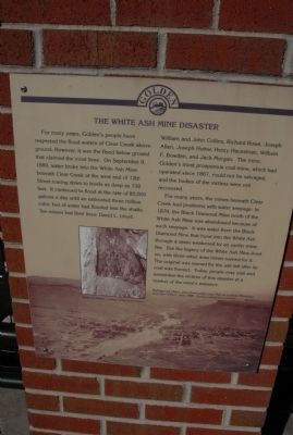
For many years, Golden’s people have respected the flood waters of Clear Creek above ground. However, it was the flood below ground that claimed the most lives. On September 9, 1889, water broke into the White Ash Mine beneath Clear Creek at the . . . — — Map (db m49900) HM
First plaque:
Dedicated
to the memory of
Joseph Allen
William Bowden
William Collins
John Collins
Henry Huesman
David Lloyd
Joseph Hutter
John Morgan
John Murphy
Rich Rowe
Who lost their lives here on
Sept. 9th, . . . — — Map (db m152733) HM
Just north of town are remnants of the Cherry Coal Mine, where 259 miners lost their lives in one of the worst mine disasters in United States history.
The St. Paul Coal Company began mining coal at Cherry in 1905 and by 1909 was mining 300,000 . . . — — Map (db m36734) HM
Coal was discovered in Moweaqua in 1886
With mining operations beginning in 1891
The method of mining was room and pillar
At a depth of 620 feet
Haulage was by mule and motor
On Christmas Eve 1932 an explosion in the mine
Claimed the . . . — — Map (db m55635) HM
The Diamond Mine of the Wilmington Coal Mining and Manufacturing Company, located near Braidwood on the Grundy-Will County line, was the site of a major mine disaster in Illinois.
The mine was on a marshy tract of land that had no natural . . . — — Map (db m6868) HM
This is the site of the Moweaqua Coal Mine Disaster which on December 24, 1932, took the lives of all 54 miners entering the mine that day. The Moweaqua Coal Mine was Shelby County's largest. An unprecedented drop in barometric pressure allowed . . . — — Map (db m55619) HM
In memory of Leslie County miners killed in Finley Coal Company mine disaster December 30, 1970 at Hyden, Kentucky
This memorial donated by Justice and Lakes Monument Company McKee, Kentucky
Lonnie Collins • Holt Couch • Howard Couch . . . — — Map (db m84412) HM
On December 30, 1970 an explosion caused by coal dust that was ignited by explosives occurred in mine shafts 15 and 16. The blast resulted in the deaths of 38 men. A lone survivor was blown out of the mine. The disaster occurred exactly one year . . . — — Map (db m87772) HM
(Side One)
Scotia Mine Disaster
One of the worst mine disasters in U.S. history. Faulty equipment ignited methane & coal dust due to lack of proper ventilation. On Mar. 9 & 11, 1976, twin explosions took the lives of 26 coal . . . — — Map (db m97157) HM
The Smith Mine is the site of the worst underground coal mine disaster in Montana history. The decaying buildings across the coulee are a memorial to the 74 men who died in the mine on the morning of February 27, 1943. Smoke pouring from the . . . — — Map (db m190113) HM
Ohio's worst mine disaster occurred in this Sunday Creek Coal Company mine when an explosion killed 82 persons. Among the dead were the company's top executives who were in the mine inspecting new safety equipment. Nine hours after the explosion, . . . — — Map (db m15611) HM
On July 3, 1872, 16 men and a 9-year old boy descended the 170 foot shaft in the Atwater Coal Company Mine located in Atwater Township south of Route 224 and East of Route 225. The mine was situated on the property known as the S.G. Shaffer Farm. . . . — — Map (db m67455) HM
On July 11, 1902, on this hillside. 112 bituminous coal miners, mostly immigrants. were killed in a gas explosion at Cambria Iron Company's Rolling Mill Mine. It was the first of four major mining accidents in PA contributing to the deadliest decade . . . — — Map (db m203729) HM
A mile west of here on June 16, 1890, 31 miners were killed by an explosion of gas at the Hill Farm Mine owned by the Dunbar Furnace Company. The explosion was one of the most deadly in the history of the coke region. Two of the bodies were . . . — — Map (db m228407) HM
Here in the Washburn Cemetery lie the remains of 61 of the 110 victims of the September 6, 1869, Avondale Mine disaster in Plymouth Township, Luzerne County. The miners, most of whom were of Welsh descent, were interred on September 9, 1869. . . . — — Map (db m99116) HM
On September 6, 1869, the mine shaft at the Avondale Mine near Plymouth, PA caught fire. 108 men and boys lost their lives when their only chance of escape was blocked. Two rescuers also perished. Avondale stands as the most deadly mining . . . — — Map (db m139417) HM
On the morning of April 7, 1911, the nearby Pancoast mine here in Throop was the scene of a disastrous fire. Seventy-two miners died by suffocation, and a government rescue worker also was killed. This tragedy soon led to the enactment, on June 15, . . . — — Map (db m67933) HM
On September 6, 1869, a fire broke out at the nearby Avondale Colliery, trapping the miners. The eventual death toll was 110. This included five boys between the ages of twelve and seventeen, and two volunteers who were suffocated while attempting . . . — — Map (db m68737) HM
On January 22, 1959, twelve men died in a tragic accident at the River Slope Mine near this site. The mine had been illegally excavated beneath the Susquehanna River at the direction of the Knox Coal Company. When the force of the ice-laden river . . . — — Map (db m10468) HM
On August 27, 1963 rescuers used a new technique to drill a borehole that successfully freed two coal miners trapped for nearly 2 weeks by a shaft cave-in 320 feet below ground. One miner was lost and the incident gained national attention and . . . — — Map (db m87542) HM
Near this site was located the mule entrance to the Cincinnati coal mine. On April 23, 1913, at 12:15 P.M., One of the worst mine explosions in U.S. history occurred in this mine. This disaster resulted in the deaths of 96 miners and 1 rescue team . . . — — Map (db m64385) HM
On December 19, 1907, an explosion killed 239 men and boys, many Hungarian immigrants, in Darr coal mine near Van Meter. Some were from the closed Naomi mine, near Fayette City, which exploded on Dec. 1, killing 34. Over 3000 miners died in December . . . — — Map (db m54926) HM
At 8:30 a.m., March 8, 1924, an explosion occurred in the Castle Gate No. 2 Mine, located about one half mile to the southeast of this site, instantly killing 171 miners. Rescue teams were rushed to Castle Gate from the surrounding mines. Wearing . . . — — Map (db m148291) HM
Winfree Memorial Baptist Church, constituted in 1852 as Jerusalem Baptist Church, originally stood to the west on Buckingham Pike. In September 1881, to better serve the coal mining community, the frame structure was rolled here on logs. On 3 Feb. . . . — — Map (db m35994) HM
1907 Fairmont Coal Company
Monongah No. 6 and No. 8 Mines
Monongah, West Virginia
At 10:20 a.m., December 6, 1907, explosions occurred at the No. 6 and No. 8 mines at Monongah, West Virginia. The explosions ripped through the mines, . . . — — Map (db m137748) HM
Site of largest mine disaster in Fayette County history. On 2 March 1915, coal dust in Layland #3 ignited, killing 112 men; 42 of 53 survivors were rescued 6 March, one mile inside 10th left section behind barricade they built. — — Map (db m140484) HM
On the morning of July 23. 1966, an explosion tore through an area of the Mount Hope Siltix Mine that was being operated by the New River Company. The blast, caused by the ignition of built-up methane gas, killed seven men and wounded two others who . . . — — Map (db m228744) HM
In memory of those who lost
their lives in the December 6, 1907 Monongah Mine Disaster
In memory of
all the unknowns who
lost their lives
on December 6, 1907 — — Map (db m175386) HM
Nearby mine supplied coal to large Wheeling Steel mill. An explosion here, 28 April 1924, resulted in third worst mine disaster in state history. 119 miners, many natives of Poland, Italy and Greece, were killed. There were no survivors. Led to . . . — — Map (db m59838) HM
Near here in Bartley No. 1 shaft mine, on Jan. 10, 1940, fire and explosion killed ninety-one miners. The names of the men who lost their lives are inscribed on monument erected in the park by the United Mine Workers of America. — — Map (db m1860) HM
On April 30, 1927, Federal No. 3 Mine exploded, killing at least 97 miners. Nine men inside survived the blast and soon reached safety. Using oxygen breathing apparatus, 21 teams conducted rescue efforts until May 24, containing fires as they went. . . . — — Map (db m74653) HM
This Memorial is dedicated to the 39 men who lost their lives in the gas explosion of the Mountain Brook Shaft of the Newburg Orrel Coal Co., Jan 21, 1886.
The shaft was located in the west end of Newburg along the B&O Railroad tracks. It . . . — — Map (db m177406) HM
The Thomas-Davis Lions Club proudly dedicates this memorial plaque to the memory of these miners who lost their lives in Thomas, West Virginia mine disasters.
Mine No. 25
February 4, 1907
Allen, Oscar • Arcani, Joe • Benuemento, . . . — — Map (db m153083) HM
A large red granite monument commemorates the 75 miners who died in the 1943 explosion at the Smith Mine. The United Mine Workers of America installed this memorial in 1947 to memorialize Montana’s worst coal mining disaster. Twenty-two of the Smith . . . — — Map (db m190162) HM
Argonaut Mine, discovered 1850, and Kennedy Mine, discovered 1856, played dramatic roles in the economic development of California. They produced $105,268,760 in gold. Kennedy Mine has a vertical shaft of 5,912 feet, the deepest in the United . . . — — Map (db m100586) HM
On Friday, September 24th, 1926, a disaster occurred at the Pabst Mine. "G" Shaft, located approximately 300 yards southwest of this spot, collapsed. 3 men riding in the cage freefell 2,600 feet. 43 men were trapped on the 8th level, 727 feet below . . . — — Map (db m45051) HM
On November 28, 1908 154 miners died in what was the worst disaster in Washington County and among the most severe in the history of US mining. The incident, and several others at the time, catalyzed public advocacy for mine safety, leading to the . . . — — Map (db m140248) HM
On the 6th of Dec., 1907 361 coal miners, many of them from countries far across the sea, perished under these hills in the worst mining disaster of our nation. The four who escaped died of injuries. — — Map (db m237520) HM
The Fraterville Mine exploded on May 19, 1902, killing all 216 miners. Poignant farewell messages were found on the bodies of Jacob Vowell, Powell Harmon, John Hendren, Harry Beach, Scott Chapman, James Brooks, R.S. Brooks, George Hutson, Frank . . . — — Map (db m102428) HM
St. Sava Serbian Orthodox Church was erected in 1894. It is the first Serbian Orthodox church built in the U.S. Rev. Sebastian Dabovich, first Priest in this parish. Born in S.F. & reared in nearby Plymouth. Inspired his people in the early 1890’s & . . . — — Map (db m11514) HM
Utica Mine, the most important mine in the Angels District, set national records in the 1890's producing more than 4 million dollars in gold in 30 months. The Utica was also the site of Angels Camp's worst mine disaster when 17 men were buried when . . . — — Map (db m25646) HM
United Mine Workers of America (UMWA) president and Congress of Industrial Organization (CIO) founder John L. Lewis (1880-1969) came to Panama, Illinois, from Iowa with his family in 1908 to work in the mines; within one year he was president to . . . — — Map (db m186233) HM
Thirty-nine corrugated metal structures mark the site of the Smith Mine, a ghostly reminder of a once vibrant mining district. The Montana Coal and Iron Company (MCI) began developing the Smith Mine in earnest after the arrival of the Montana, . . . — — Map (db m190143) HM
It took millions of miles of copper to build the telegraph, telephone, and electrical lines that transformed the United States from a collection of small, isolated communities to a cohesive, industrialized nation. Looming gallows frames and the . . . — — Map (db m128116) HM
These sheave wheels from the Speculator Mine were used to hoist the bodies of the 168 miners who died in the Granite Mtn. Mine Disaster, June 8, 1917.
It remains the worst metal mining tragedy in U.S. History. The Granite Mtn. shaft was burned . . . — — Map (db m128411) HM
It took millions of miles of copper to build the telegraph, telephone, and electrical lines that transformed the United States from a collection of small, isolated communities to a cohesive, industrialized nation. Looming gallows frames and the . . . — — Map (db m128045) HM
It took millions of miles of copper to build the telegraph, telephone, and electrical lines that transformed the United States from a collection of small, isolated communities to a cohesive, industrialized nation. Looming gallows frames and the . . . — — Map (db m184718) HM
Paired Ionic columns support a classical one-story porch while the parapet atop the curved two-story bay window evokes the image of a medieval castle. Kitty Paxson and her husband, pharmacist Robert Paxson, lived in the elegant brick residence in . . . — — Map (db m184626) HM
In June of 1917 a strike broke out in the aftermath of the deadly Speculator Mine disaster where 164 lives were lost. Frank Little, one of the "toughest, most courageous and impulsive" leaders of the Industrial Workers of the World came to Butte to . . . — — Map (db m234841) HM
Frontenac, Kansas first came into being when the coal mining industry moved into the area during the late 1800s. The Santa Fe Railroad leased the land around what is present-day Frontenac, and formed the Cherokee and Pittsburg Coal and Mining . . . — — Map (db m35604) HM
Platted in 1905 by George Lamport and Robert Leavens, Bearcreek was the center of an extensive underground coal mining district. At its height during World War I, Bearcreek boasted a population of nearly 2,000 people. The community was ethnically . . . — — Map (db m190160) HM
Named for entrepreneur Cuyler Adams and his faithful dog Una, the Cuyuna Ranges lies at the westernmost edge of a ring of iron ore that circles Lake Superior. The smallest of Minnesota’s three northern iron ranges, the Cuyuna was also the last to be . . . — — Map (db m43934) HM
John L. Lewis, President
United Mine Workers of America
1920 to 1960
Greene County, Pennsylvania
proudly dedicates this monument
to all coal miners
On December 6, 1962, 460 feet directly beneath this site, 37 miners lost . . . — — Map (db m16270) HM
In loving memory of the Sons of Molise who tragically lost their lives in the mining disaster
Monongah December 6th 2007
The President Sen. Michele Iorio
Monongah 1907-2007 A tragedy that will never be forgotten
Italian-American . . . — — Map (db m175780) HM
Side 1
The Coal Industry at Powhatan Point
The Pittsburgh No. 8 coal seam, located 100 feet below river level at Powhatan Point, extends across much of eastern Ohio, western Pennsylvania, and northern West Virginia. The Cleveland and . . . — — Map (db m78501) HM
One of the original 7 US Bureau of
Mines train cars was headquartered
near C&O tracks, 1911–1933. The
wooden car, with crew & supplies,
traveled the WV region to give
mine safety & rescue training and
to aid in mine disaster rescue
efforts. . . . — — Map (db m126017) HM
With the birth of the Coal Industry, Mount Hope would play a very important role.
During Mount Hope's early history, settlers began removing coal from a seam on the side of a mountain. Commercial mining of coal had been in effect since the . . . — — Map (db m161343) HM
On the hill to your right stand the remains of the Argonaut Mine gallus (headframe), beneath which 47 miners were lost when a fire broke out deep in the main shaft on August 27, 1922. At that time the Argonaut was one of the deepest gold mines in . . . — — Map (db m94781) HM
With the discovery of coal in Cherokee and Crawford Counties in the late 1860's, thousands came to work the mines. Some came from American towns and cities but most were immigrants from Europe. Over fifty nationalities settled in this area. Many . . . — — Map (db m39738) HM
In the excess of her sorrow
brave beyond words
In memory of the widowed wives and
mothers of the victims of
the Monongah coal mine
disaster December 6, 1907.
All of them long-gone but
forever in our hearts
We hear their ghostly . . . — — Map (db m175692) HM
INDIANS have lived in the greater Bay Area for thousands of years. Black Diamond was located in the backcountry between three tribes: Chupcan (Concord), Volvon (Clayton), and Ompin (Pittsburg). All spoke the Bay Miwok language. With the arrival . . . — — Map (db m198457) HM
On Aug. 4, 1917 about 7:40 AM
an explosion in the West Kentucky
Coal Company's #7 mine shattered
the community of Clay. The worst
mine disaster in state history was
caused by methane gas and an
opened-flame headlamp. At the
time of the . . . — — Map (db m172081) HM
Coal and Its Impact on Thomas
The history of the coal industry is inextricable from the development of the Thomas Commercial Historic District. If the Davis brothers had not invested in coal mining and transportation in the area, the town . . . — — Map (db m153089) HM
On October 23, 1958, a coal mining disaster in Springhill, Nova Scotia trapped 174 men underground. The coverage of this disaster was the first international event to be broadcast live on television.
In the hope of harnessing the media . . . — — Map (db m115128) HM
Wise. Known variously through the years as Big Glades, Gladesville, and Gladeville, Wise took its current name in 1924 after Henry Alexander Wise, Governor of Virginia before the Civil War. Located on the road between Union
Kentucky and the . . . — — Map (db m90857) HM
Panel 1: Mt. Harris 1914-1958
The Colorado-Utah Coal Company's Harris Mine was opened June 12, 1914 under the direction of George Homer and Bryon Harris. The camp was first named Harris, but later changed, due to another established post . . . — — Map (db m116920) HM
Following the footprint.
Every mine explosion leaves behind a footprint that offers clues to investigators
as to where the blast originated and how the force traveled from the ignition
point. The footprint left behind in the Upper Big Branch . . . — — Map (db m137546) HM
Dedicated to All Coal Miners
In Memoriam
Nature bestowed Pennsylvania with deposits of Anthracite coal which contains the highest percentage of fixed carbon. The coal fields approximately 600 square miles from Susquehanna and Wayne Counties . . . — — Map (db m105225) HM
* Inflectional forms of words are their plurals, singulars, and possessives as well as gramatical tenses and similar variations.