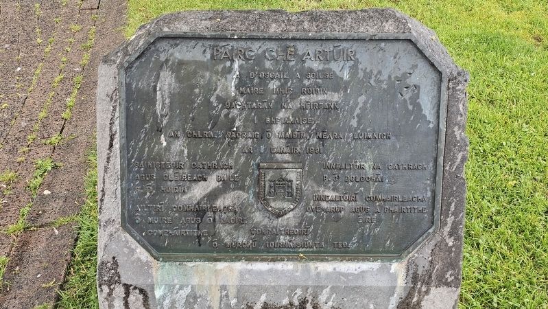
Opened by Her Excellency Mary Robinson, President of Ireland, in the presence of Cllr. Paddy Madden, Mayor of Limerick, on 1st January 1991.
City Manager and Town Clerk, J. J. Higgins •
City Engineer, P.A.F. Dullaghan •
Consultant . . . — — Map (db m300818) HM
1824–2024 This plaque was erected in 2024 to commemorate the 200th anniversary of the laying out of Athlunkard Street, April 26th, 1824. — — Map (db m300533) HM
Scion of a prominent Limerick family, Joseph Barrington became a freeman of Limerick city and was created 1st Baronet Barrington in 1831. Together with his four sons, he founded Barringtons’ Hospital, for long an important hospital for Limerick, . . . — — Map (db m300494) HM
The Barrington family, known for their good works spent £10,000 on the building of the hospital in 1829. Although it functioned as a general hospital, it specialised in the care of children. The hospital closed as a public institution in 1988 . . . — — Map (db m300817) HM
This house, an Episcopal Residence from 1661 to 1784, was restored by Limerick Civic Trust. Officially opened on 20th March 1990, by Alderman Gus O’Driscoll, Mayor of Limerick. — — Map (db m300556) HM
This 18th century town house was a residence for Church of Ireland Bishops until 1784. It was restored by Limerick Civic Trust in 1989/90. — — Map (db m300565) HM
Limerick Civic Trust dates the building to the 17th century and considers it to be the oldest standing domestic building in English Town. This was the official residence for the Church of Ireland Bishops until they moved to a new house in Henry . . . — — Map (db m300557) HM
The Bishop’s Palace King’s Island King’s Island is surrounded by the Shannon and Abbey Rivers. You are standing in the oldest part of Medieval Limerick in what was known as Englishtown. The walls of Englishtown were built in the 12th & 13th . . . — — Map (db m300558) HM
This building is known as Bourke House. It was occupied by Alderman John Bourke in 1641 according to the Civil Survey of 1654. It is also reputed to be the remains of a medieval stone residence said to have been built by the O’Briens after Donal . . . — — Map (db m300530) HM
This plaque is erected to the memories of Bryan Whelan and T.J. O’Herlihy who died tragically while working on Thomond Bridge on 29th August 2015. May they rest in peace. — — Map (db m300869) HM
(Main panel)[Gaeilge:]
An Tiomnaḋ
Do tógaḋ an leaċt so, le bailiú deóntaċ puiblíde airgid, i gcuimne na bfear so Luimniġ .i.
Éamonn Ó Dálaiġ, Concubar Colbárd,
agus
Tomás . . . — — Map (db m300625) WM
[Gaeilge:] Cuimhneachán 1916 Tá an cuimhneachán tiomnaithe i gcuimhne na ndaoine a fuair bás ar son saoirse na hÉireann agus in Éirí Amach na Cásca 1916, idir na daoine sin a fuair bás agus iad ag troid agus na ceannairí a . . . — — Map (db m300629) HM
On February 23rd 2011, this tree was planted by Limerick Civic Trust in memory of our inspirational founder member and Director Denis M. Leonard. The tree is planted near the restored Russell Fountain, a project of which Denis was particularly proud. — — Map (db m300213) HM
[Gaeilge:] Leacht na nDugairí Rinne Méara Luimnigh, Kevin Kiely nochtadh oifigiúil air ar an Aoine an 18ú Meitheamh 2010 le ceiliúradh a dhéanamh ar chion tairbhe na nDugairí i Luimneach. I láthair bhí: Cathaoirleach Choiste . . . — — Map (db m300639) HM
The exchange was built in 1673. This impressive facade of hewn stone with its seven Tuscan columns linked by a handsome balustrade is all that remains of the original building. The structure was rebuilt in 1702 and 1778. It fell into disuse when the . . . — — Map (db m300528) HM
Built in the late 16th or early 17th century. Originally known as Whitamore’s or Limerick Castle, but colloquially called Fanning’s Castle after Dominic Fanning merchant and Mayor of Limerick who lived here and was executed by the Cromwellians in . . . — — Map (db m300794) HM
The Georgian House and Garden No.2 Pery Square, Tontine Buildings, Limerick Formally opened on 10th December 1999 by Mary McAleese President of Ireland In the presence of Cllr. Jack Bourke Mayor of Limerick. A Limerick Civic . . . — — Map (db m300287) HM
The oldest part of the graveyard around St Mary’s Cathedral dates from the 12th century, but the earliest burial records date from 1726. Still in use as an active graveyard, this churchyard has been hallowed ground for nine centuries. Remarkable and . . . — — Map (db m300435) HM
The oldest part of the graveyard around St Mary’s Cathedral dates from the 12th century, but the earliest burial records date from 1726. Still in use as an active graveyard, this churchyard has been hallowed ground for nine centuries. Remarkable and . . . — — Map (db m300621) HM
The street is dedicated to the memory of Sir Harry (d. 1844) and Lady Hartstonge who were eminent benefactors to the city. They lived on this street. — — Map (db m300320) HM
Island Road roughly follows the route of the old city walls. The walls erected in 1237, separated the citizens of the city from the other inhabitants on the Island. What remains of the walls, dismantled in 1760, can be seen here. Medieval Limerick… . . . — — Map (db m300536) HM
[Upper panel:][Gaeilge:] Anseo chónaigh Seán Ó Dálaigh (1845–1916) Fínín I ngéibheann 1884–1896 • Méara Luimnigh 1899–1902 Agus a nia an ceannfort Éamonn Ó Dálaigh (1891–1916) Ceannasaí na gceithre chúirt Baile Átha . . . — — Map (db m300224) HM
The kiss of the sun for pardon The song of the bird for mirth One is nearer God’s heart in a garden Than any place else on earth In fond memory of Katie (Cis) Smyth 1897–1995 who as a labour of great love for this cathedral at the age . . . — — Map (db m300433) HM
The castle was built by Prince John of England c.1210 later to become King. To protect and maintain Norman power in Limerick and Munster. Today the restored castle is open to the public and houses an imaginative exhibition of the history of the . . . — — Map (db m300563) HM
This school was built in 1843 from proceeds of a trust set up by William Leamy. The school was closed in 1952. Frank McCourt was a pupil here. — — Map (db m300319) HM
Motor Races 1935 Winner Luis Fontes 1936 Winner Andrew Hutchinson 1938 Winner J.D. McClure • The Duke of Grafton died after crashing his Bugatti on the first lap in 1936. • Scrutineering was held here in Pery Square. • This plaque was erected by . . . — — Map (db m300281) HM
We the workers of Limerick extend fraternal greetings to workers of all countries and we call upon our brothers and sisters to show solidarity with workers’ struggles, whatever they are and wherever they may be. Limerick Council of Trade Unions — . . . — — Map (db m300317) HM
Maidenhair Fern, Adiantum capillus-veneris, is a native plant which is locally frequent in the Aran Islands and the Burren, and also in Sligo and Donegal, Isle of Man, south Wales and south-west England. It has a world-wide distribution, and . . . — — Map (db m300437) HM
Contracted for in the year 1844 during the mayoralty of the Right Worshipful William I. Geary M.D. The expense of its erection borne by the corporation and by presentments from the county and city grand juries Opened in the month June 1846 The Right . . . — — Map (db m300351) HM
(South face)
Michael Hogan The Bard of Thomond 1826 – 1899 Statue erected by Peter James Hogan in memory of his father Peter John Hogan of 47 Mary Street, Limerick City, cousin to the Bard, wounded by sniper’s bullet during the Irish . . . — — Map (db m300562) HM
Originally known as Main Street in Medieval times. The street is now named after St. Nicholas of Myra, better known as Santa Claus. In times past the local parish church of St. Nicholas stood on the site now occupied by a local business called Styx. — — Map (db m300613) HM
Originally known as Main Street in Medieval times. The street is now named after St. Nicholas of Myra, better known as Santa Claus. In times past the local parish church of St. Nicholas stood on the site now occupied by a local business called Styx. — — Map (db m300615) HM
The Freemasons have been in Limerick since the first lodge was founded in 1732. This building, now under restoration, is the first building in the city to be owned by the Freemasons. The building when completed will house a museum, a library, will . . . — — Map (db m300609) HM
Built on the main spine of Limerick’s new town, Newtown Perry, Number 44 dates from c 1825. The first occupant of this fine Georgian town house is thought to have been John Fitzgerald Gabbett in 1827. His family lived in Strand House where the . . . — — Map (db m300693) HM
It is thought that the original building constructed in 1640 was built on the site of a 13th century Augustinian Abbey. The present structure was completed in 1765 at a cost of £700. Named after Gerard Griffin novelist, poet and later Christian . . . — — Map (db m300617) HM
(Left inset) History of the People’s Park 1769 Plans for a Georgian Newtown for Limerick were drawn up for landowner, Edmund Sexton Pery. Christopher Colle’s Map from 1769 clearly includes provisions for a square and park space in . . . — — Map (db m300146) HM
This epic film is a ferocious re‑enactment of the rise and fall of the Roman Empire, at the time of the Emperor Marcus Aurelius and subsequent disastrous rule of his son Commodus. This Academy Award winning film, has a star studded cast, and . . . — — Map (db m300138) HM
This film, a rural Irish masterpiece, was adapted by Jim Sheridan from a stage play written by John B. Keane. It tells the story of an Irish farmer willing to go to any lengths, to keep a field his family had cultivated for generations. His powerful . . . — — Map (db m300139) HM
This film, a recognised classic, tells the story of the harsh life and realities of a professional rugby footballer in England. His powerful performance in the leading role as Frank Machen, launched a remarkable debut and won for Richard Harris . . . — — Map (db m300140) HM
Richard Harris Richard Harris playing King Arthur in Camelot (1967). Holding aloft a reversed sword, he proclaims: “PEACE NOT WAR”. The Harris Family The Harris family business included flour milling, a huge bakery in . . . — — Map (db m300137) HM
Robert Graves (1895–1985) Poet and author Frequented The Locke Bar while stationed in Limerick during the War of Independence (1919–1921) serving as an officer in the Royal Welsh Fusiliers — — Map (db m300781) HM
The adjoining stone is part of a lintel from our first chapel in Limerick City founded near Fish Lane 1633 after the suppression of our monastery at Adare — — Map (db m300759) HM
This Cathedral of St Mary the Virgin has stood at the heart of Limerick for nine centuries. It is on the site of a one-time Viking Parliament and a later Royal Palace of the Kings of Munster. It was founded in 1168 by King Dónal Mór O’Brien, died . . . — — Map (db m300377) HM
This Cathedral of St Mary the Virgin has stood at the heart of Limerick for nine centuries. It is on the site of a one-time Viking Parliament and a later Royal Palace of the Kings of Munster. It was founded in 1168 by King Dónal Mór O’Brien, died . . . — — Map (db m300510) HM
Commissioned by Domhnall Mor O’Brien c.1168. The cathedral is the oldest building still used for its intended purpose. Without doubt this is one of the most important medieval buildings in the country. — — Map (db m300432) HM
To the honour and glory of God under the invocation of St. Michael Archangel this church was rebuilt A.D. 1881 except part of nave and transepts. His Holiness Leo XIII, Sovereign Pontiff The Most Rev. George Butler D.D., Lord Bishop of Limerick The . . . — — Map (db m300760) HM
By authority of Parliament and through liberal grants from the Grand Juries of Limerick and Clare Alderman Jerome Counihan J.P. Mayor of Limerick 1882–1883 was enabled to declare this bridge free of toll on Easter Monday 26 March 1883 William Boyd . . . — — Map (db m300631) HM
The Battle of Aughrim, fought on 12th July 1691, was the decisive battle of the Williamite / Jacobite campaign in Ireland. The army of James II was defeated and it was in effect the end of the Jacobite cause in Ireland. Patrick Sarsfield proceeded . . . — — Map (db m300572) HM
This vault, dating from 1753, is the resting place of the eminent Sexten family, descendants of Edmond Sexten, author and Mayor of Limerick, and a friend and confidant of King Henry VIII. The vault is decorated with ornate carvings . . . — — Map (db m300439) HM
[Gaeilge:]
Bhí barracáid mhíleata ag arm na Breataine ar Dhroichead Thuamhain le linn Stailc Ghinearálta stairiúil Aibreán 1919, ar a dtugtar go coitianta Sóivéid Luimní.
[English:]
Thomond bridge was . . . — — Map (db m300570) HM
While the existing church was erected in 1827, there is said to have been a church on this site since 561. The ancient parish church of St. Munchin may have served as a cathedral long before St. Mary’s was built. A unique feature of the church was . . . — — Map (db m300548) HM
This star commemorates the life of Limerick-born Hollywood actor Constance Smith, marking her international film career stretching from the 1940s to the 1960s. Created by artist Mary Conroy, the star was commissioned by Ormston House with support . . . — — Map (db m300212) HM
This bridge was erected by Limerick Civic Trust. It was officially opened by the Right Worshipful Cllr. Jack Bourke, Mayor of Limerick, on 21st March 1987. — — Map (db m300321) HM
(West face) Erected by Public subscription in appreciation of the enterprise
and usefulness of Alderman Peter Tait
(South face) As an employer of large numbers of the Working Classes, and of his
liberality and benevolence as a . . . — — Map (db m300141) HM
Terry Wogan 1938 – 2016 Born in Limerick Officially unveiled by Cllr Kieran O’Hanlon Mayor of Limerick On Saturday 24th June 2017 In the presence of Chief Executive Conn Murray, Sculptor Rory Breslin This sculpture was commissioned by . . . — — Map (db m300637) HM
The Tholsel founded in 1449 was the earliest City Hall, later to become a jail.
“This year the foundation of the Tholsel’s laid Where justice in those days was well displayed The use diverted, now ’tis the common jail Where men do . . . — — Map (db m300801) HM
The original bridge, which connected King’s Island with the Co. Clare side of the river, was built sometime between 1185 and 1210. This structure collapsed in 1292 killing 80 men. The bridge was then reconstructed with fourteen unequal arches. . . . — — Map (db m300607) HM
This humourous Gothic Style folly with exaggerated crenellations was designed and built by the architect James Pain around 1840. James and his brother George were also responsible for the design and construction of Thomond Bridge. — — Map (db m300603) HM
(Main Plaque)
The Treaty of Limerick
Signed
A.D. 1691
(Mayoral Plaque)
This pedestal was erected May 1865. John Rickard Tinsley, Mayor.
(Side inscription, Latin)Urbs antiqua fuit studiisque asperrima . . . — — Map (db m300601) HM
The U.N. Peace Garden Memorial pays tribute to the Irish men and women who have served on Peacekeeping Forces, and lost their lives whilst on peacekeeping missions in diverse places such as the Lebanon, Somalia, the Congo, Liberia, . . . — — Map (db m300398) WM
Designed by James Pain Built in 1826 for Protestant widows. They were funded through bequests provided by Mrs. Hannah Villiers in her will. — — Map (db m300542) HM
Mrs. Hannah Villiers endowed the buildings on this site in her will in 1821. The construction took place in the Bishop’s Garden in 1823. Of interest from a medieval perspective are the remains of the two towers, which today form part of the boundary . . . — — Map (db m300540) HM
Welcome St Mary’s Cathedral has stood at the heart of Limerick for nine centuries. It is on the site of a one-time Viking Parliament and a later Royal Palace of the Kings of Munster. It was founded in 1168 by King Dónal Mór O’Brien (d.c.1194), . . . — — Map (db m300495) HM
Romanesque in style, tradition claims that the West Door was once the entrance to King Dónal Mór O’Brien’s palace. Composed of five arches or ‘registers’, supported on engaged columns with capitals of interlaced designs, the second register is . . . — — Map (db m300407) HM
This living willow sculpture, made from native Irish willow is inspired by the O’Dea Crozier, on display at the Hunt Museum. This sculpture makes up part of a walking trail around the locality, where woven willow sculptures are dotted in various . . . — — Map (db m300619) HM