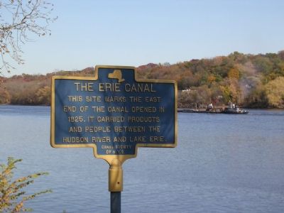
The Erie Canal.
This site marks the east
end of the canal, opened in
1825. It carried products
and people between the
Hudson River and Lake Erie
Albany Basin.
For nearly 100 years boats
entered the Erie Canal at
nearby Lock 1, . . . — — Map (db m5174) HM
Albany's coomercial growth boomed after
the Erie Canal was completed
in 1825. From a small basin,
barges entered the river through a final lock.
Lining a mile of the canal above the basin was in
the Lumber District, where towering piles . . . — — Map (db m227414) HM
The Erie Canal flowed through Cohoes along two distinct paths during the 19th century. The first phase, 1825-1841, is commonly referred to as "Clinton's Ditch" after New York Governor DeWitt Clinton, who was the foremost advocate for construction . . . — — Map (db m42224) HM
For nearly a century, canal boats were pulled by mules and horse over this portion of New York State's famed Erie Canal.
One of the slowest and most crowded parts of the waterway started to the north of the Flatts at Maplewood. Here Began the . . . — — Map (db m14742) HM
This Greek-revival building was one of several weigh stations along the Canal used to levy the tolls for barges carrying merchandise and farm goods.
Until 1850 freight cargoes were measured by the displacement theory, but this hydraulic type . . . — — Map (db m40999) HM
In Memory of
Gouverneur Morris
The man whose hand wrote
the Constitution of the United States
Born January 31, 1752 - Died November 6, 1816
Interred in the Gouverneur Morris Tomb
In Stanns Churchyard
Washington's Minister to . . . — — Map (db m209730) HM WM
The Erie Canal tied together western New York and became a conduit for ideas as well as for commerce. Seneca Falls was the site of the first Women's Sufferage convention, organized by Elizabeth Cady Stanton and Lucretia Mott in 1848 to advocate . . . — — Map (db m83670) HM
The opening of the Erie Canal had a huge economic impact on the citizens of New York State. Producers could afford to ship products to previously inaccessible markets at a cost that dropped from $100.00 per ton (by wagon) to just a few dollars. . . . — — Map (db m83674) HM
In 1807 Jesse Hawley, a prisoner in the Canandaigua jail, wrote a series of essays proposing a waterway from Lake Erie to the Atlantic Ocean. Following the War of 1812 the settling of western New York and Ohio resulted in an increased demand for . . . — — Map (db m83708) HM
Construction of the Erie Canal was hailed as the greatest engineering accomplishment to that time. Under the leadership of Governor De Witt Clinton, construction began July 4, 1817. With little technical knowledge, thousands of workers surveyed, . . . — — Map (db m88628) HM
A Landmark and Pride in Our Community. The Town on Montezuma purchased the lot and is restoring it for it [sic] significance to the town's history. Volunteers helped clear the site and in a community effort has [sic] taken the important first step . . . — — Map (db m83561) HM
Early Aqueduct This towpath leads to the Richmond Aqueduct built 1849 second largest aqueduct carrying Erie Canal waters over the Seneca River. — — Map (db m83562) HM
In 1828, the Cayuga-Seneca Canal opened in Montezuma allowing transportation of people and goods into the Finger Lakes and beyond by connecting with the Erie Canal at this site. The Exchange Hotel provided lodging for travelers and was the center of . . . — — Map (db m83560) HM
Old Erie Canal Completed from Utica to here 1819. The "Montezuma" built here was the first boat on the canal. Took passengers to Syracuse 1820. — — Map (db m83542) HM
Opened in 1828 Cayuga Seneca Canal Extended navigation of the Erie Canal to Finger Lakes Site of crossover bridge and Exchange Hotel — — Map (db m83547) HM
Lock 52 in Port Byron was a busy place prior to 1917. In the vicinity of the lock, you would have seen a bustling waterfront, with dozens of boats locking up or down the canal. At Tanner's Dry Dock, just up the canal from the lock, canal boats were . . . — — Map (db m83641) HM
During the ice ages of the last 2 million years, glaciers sculpted the land surface forming, amongst other features, the many rounded and elongated hills called drumlins that are seen from the Thruway between Rochester and Syracuse. From this . . . — — Map (db m103583) HM
Lock 52 on the Erie Canal was once a busy place. Built in 1851 and lengthened on the berm side in 1887 to accommodate two boats hitched together in tandem, the lock created a popular stopping point for canal boatmen. The 11-foot lift at Lock 52 . . . — — Map (db m103581) HM
The O.B. & H.E. Tanner Dry Dock was established near Lock 52 in Port Byron in 1873, replacing the earlier Ames Dry Dock. In its heydey, Tanner built and repaired a variety of canal boats, employing a crew of 18, including a shipwright, carpenters, . . . — — Map (db m83644) HM
About two hundred feet from here was once the location of the D. B. Tanner Dry Dock, built in 1863 on the former Clinton's Ditch alignment. Craftmen built and repaired canal cargo boats in the dry docks that carried grain, coal, lumber and the . . . — — Map (db m103582) HM
Construction of the Erie Canal was hailed as the greatest engineering
accomplishment to that time. Under the leadership of Governor De Witt Clinton,
construction began July 4, 1817. With little technical knowledge, thousands
of workers . . . — — Map (db m146448) HM
The Erie Canal in Port Byron When the original Erie Canal or "Clinton's Ditch" was completed here in 1819, Port Byron was transformed from a frontier settlement to a thriving canal town. Indeed, the local citizens were so hopeful with the new . . . — — Map (db m103580) HM
This 1894 saloon and hotel belonged to the Van Detto family, recently arrived Italian immigrants. Located a few hundred feet east of Lock 52, the Erie House was a popular destination for the canal community. — — Map (db m103562) HM
The Chemung Canal 1833-1878
here joined the Chemung
River, extending northward
linking the river to the
Erie Canal via Seneca Lake. — — Map (db m32306) HM
A Dam on Tonawanda Creek Tonawanda Creek was the only section of the original Erie Canal that was not man-made. The problem was that the creek level ran 4-½ feet too low. The alleviate this, a wooden dam was constructed in 1823 just west . . . — — Map (db m98569) HM
During more than 175 years of existence, the Erie Canal has followed more than one path. In some places, two or three generations of Canal infrastructure still exist side by side. When technology, especially mechanized boats, made it possible for . . . — — Map (db m94637) HM
Following La Salle's arrival at the Niagara River in 1678, that waterway between Lakes Erie and Ontario became a natural route to and from the river during the 18th century. Permanent settlement of the Western New York began in 1800 following the . . . — — Map (db m24593) HM
The black rock that gave this area its name was located in the Niagara River at the bend of the present day Niagara Street, near School Street, north of where the Peace Bridge is now situated. Comprised of Onondaga limestone, the rock ledge jutted . . . — — Map (db m98187) HM
Black Rock Neighborhood The Black Rock neighborhood has endured for over 200 years and is the oldest intact neighborhood in the City of Buffalo. Black Rock was once an independent village and rival of the Village of Buffalo. The neighborhood . . . — — Map (db m93804) HM
Tow Path Park The “Black Rock” The black rock that gave the area its name was situated in the Niagara River just north of where the Peace Bridge is now, near the foot of present-day School Street. It was 200 feet wide, rose about . . . — — Map (db m140711) HM
From Frontier to Major City
In the early 1800s, Buffalo was a sleepy village known as New Amsterdam, on the edge of America's then western frontier. Holland Land Company surveyor Joseph Ellicott, inspired by Pierre L'Enfant's radial . . . — — Map (db m92798) HM
The presence of a vast inland sea and its wide river tributary in western New York soon attracted settlers. The tiny village of Black Rock, north of Ellicott's Niagara Square, was expected to flourish, however, not Buffalo. Black Rock already has an . . . — — Map (db m92835) HM
Welcome to one of the most historic places in Buffalo - the place where villagers built a harbor that, in turn, built a city. The parkland, promenade and restored lighthouse here were once key elements of the old Port of Buffalo. Early in the 19th . . . — — Map (db m84923) HM
Wheat was one of the first agricultural products planted by European colonists in the New World. In colonial times, it was not only a staple of life, but also became an item of national and foreign trade. The western movement of population . . . — — Map (db m85538) HM
During the first half of the twentieth century, over 30 concrete grain elevators lined Buffalo's inner and outer harbors, representing the culmination of over 60 years of grain elevator design. Beginning in 1842 with entrepreneur Joseph Dart and . . . — — Map (db m85435) WM
In the years following the opening of the Erie Canal, Buffalo's harbor was becoming increasingly clogged with ships awaiting their turns to unload their cargos. A full team of dock workers could unload at most 2,000 bushels a day, and even then, . . . — — Map (db m85530) HM
Buffalo was the leading wheat market in the United States for the first three decades of the twentieth century. However, by the 1930s, Buffalo's strategic position in the grain trade weakened as U.S. and Canadian grain began to bypass the port's . . . — — Map (db m85484) HM
Residents of the "Towpath" fished and hunted the Erie Canal from a cluster of weather beaten homes, hunting and fishing clubs, taverns and stores leaning at strange angles, perched on wobbly stilts. Fishing was a popular pastime, as well as an . . . — — Map (db m80459) HM
The maritime industry of the Great Lakes expanded greatly after completion of the Erie Canal in 1825. The canal allowed a growing U.S. population into the Midwest, which turned the Great Lakes into busy nautical highways for moving wheat, corn, . . . — — Map (db m86025) HM
You are looking across a restoration of the Commercial Slip, originally the western terminus of the Erie Canal. In its heyday, this area was one of the world's great transportation centers, teeming with canal, lake, and rail traffic, a busy port . . . — — Map (db m84559) HM
Commercial Slip connected the Buffalo River to the Erie Canal mainline, 100 yards northeast of this site. It marked the original terminus of the Erie Canal, but was soon joined by many other artificial waterways around Buffalo Harbor. As commerce . . . — — Map (db m84868) HM
Already a major transportation center, Buffalo was evolving into a center of industry and and manufacturing. At the height of the canal era, in the mid-1800s, countless manufacturing enterprises took advantage of the huge volume of raw materials . . . — — Map (db m231814) HM
When the Erie Canal was completed here in October 1825, Buffalo was transformed from a small lakefront hamlet to a thriving muscular metropolis. Buffalo was the port where grain, lumber, and other products from the interior of the American continent . . . — — Map (db m84859) HM
Pre-1800 The Ongiara Confluence of Little Buffalo Creek and the Buffalo River with Lake Erie in the background, 1815. The region's original inhabitants were the Ongiara, a peaceful Iroquois tribe, from whom the name Niagara is derived. Long . . . — — Map (db m84777) HM
Buffalo’s Birthplace: Where the Erie Canal Joins the Commercial Slip Look closely at this wonderful picture of Buffalo’s Waterfront in its heyday for evidence of life in those early days before the railroads took over the waterfront. Note . . . — — Map (db m140650) HM
Canal and Harbor Transforming Buffalo The Erie Canal formally opened on Oct. 26, 1825, connecting the heartlands of the continent to the rest of the world. As the engineering marvel of its time, the canal helped transform Buffalo into the . . . — — Map (db m140745) HM
The Erie Canal was America's most successful and influential public works project. Completed in 1825, the 363-mile-long waterway established the first all-water route for navigation between the Atlantic Ocean and the upper Great Lakes, opened the . . . — — Map (db m84822) HM
There was fierce competition between Buffalo and Black Rock for the Canal's western terminus. Albany, the link to New York City, emerged as the perfect choice for the eastern end of the Canal. The western end was a far less obvious proposition. . . . — — Map (db m84496) HM
In 1926, the Hamburg drain, a major sewer line draining South Buffalo was built; as a result, the Commercial Slip, the Erie Canal's original western terminus, was filled in. Today the Commercial Slip has been restored: the redesign incorporates . . . — — Map (db m84477) HM
The background map is based on an early 20th century map surveying the canal system of New York, expanded to show the network of shipping routes that grew in the wake of the Erie Canal. There is no clearer picture of America's growing economy: the . . . — — Map (db m84908) HM
The Erie Canal This site marks the west end of the canal opened in 1825. It carried products and people between Lake Erie and the Hudson River. Two Waterfronts The convergence of lake and canal made possible the . . . — — Map (db m84473) HM
Skeptics dubbed the project "Clinton's Folly" and "Clinton's Ditch" when construction of the Erie Canal began near Rome on July 4, 1817, deriding both the project and its principal promoter. Things were very different by October 24, 1825 when . . . — — Map (db m84848) HM
The Immigrant Steps. Building Buffalo. Great waves of 19th Century immigration flowed through East Coast ports to Buffalo. Thousands traveled by water vessels, while others took wagons from New England and Pennsylvania to ships headed west. Many . . . — — Map (db m140646) HM
Lifting Buffalo to World Renown. In 1924 Buffalo led the world in handling grain. 300,000,000 bushels passed throught Buffalo harbor, unloaded, lifted, stored, and reloaded by the grain elevators that still stand tall along the banks of the . . . — — Map (db m84694) HM
The Ruins at Canalside. Drinking in 19th Century Buffalo. The authentic remnant of Canal District commerce known now as the Ruins at Canalside, was home to a prominent Commercial Slip building that saw multiple uses in the mid-19th Century as the . . . — — Map (db m140645) HM
It was at this spot on the morning of October 26, 1825, that Governor DeWitt Clinton officially opened the waterway that transformed America. More than eight years had passed since he broke ground on the canal, and after 363 miles, the engineering . . . — — Map (db m84500)
The Niagara River between Lakes Ontario and Erie was the natural route to the interior of the continent. Following the arrival of French explorers in 1678, missionaries, traders, troops and settlers traveled by its waters. At the outlet of the . . . — — Map (db m57072) HM
Strawberry Island formed near the end of the Wisconsin Ice Age about 12,000 years ago. When meltwaters broke through gracial till and created the present course of the Niagara River, gravel and sand carried downstream by river currents settled out . . . — — Map (db m101061) HM
Welcome to Tonawanda Gateway Harbor - where the Niagara River meets the Erie Canal. Prior to the 1800's this area was a wilderness frequently traversed by Seneca Indians from the Iroquois Confederacy. The first known white settlers were Henry . . . — — Map (db m87802) HM
You are standing on the bed of the Erie Canal, a 363 mile long, 40 ft. wide, 7 ft. deep "ditich" built from 1817 to 1825 that connected Lake Erie waters with the Hudson River and ultimately the Atlantic Ocean. It unleashed a flood of products, . . . — — Map (db m98540) HM
To avoid the strong current of the mighty Niagara River, the Erie Canal was built adjacent to the river from here to Buffalo in 1825. — — Map (db m78352) HM
In 1884, the Tonawanda Gas Light Company was incorporated to supply gas to both Tonawanda and North Tonawanda for street and house lighting. The "gas works" was located on property once owned by Mary Long. Between the Canandaigua and Erie . . . — — Map (db m166212) HM
During the 1800s, many Americans and newly arrived immigrants were eager to move west, but this undertaking proved difficult because of the Appalachian Mountains. A natural barrier running from Alabama through Pennsylvania, New York and on into . . . — — Map (db m77385) HM
Thanks to the Erie Canal, the Niagara River, a naturally commodious harbor and a growing railroad center, the Tonawandas became a thriving lumber port during the last half of the nineteenth century. Lumber from Minnesota, Wisconsin, Michigan and . . . — — Map (db m166243) HM
An Overview
In the spring of 1823, work on the Erie Canal at this end of the state began with the building of a dam. Its purpose was to raise the water level of Tonawanda Creek 4 to 4 1/2 feet so that its ten-mile stretch between Pendleton . . . — — Map (db m77499) HM
In December of 1828, Benjamin and Mary Hershe Long arrived here from Lancaster County, Pennsylvania, in a covered wagon drawn by oxen. With them were their five daughters, ranging in age from 6 months to 16 years.
Their home, built the following . . . — — Map (db m77330) HM
Life on the Canal Boat The average canal boat owner was a family man, and often his family traveled the canal with him. Living quarters were the cabin under the stern deck and in the small space a woman did her washing and ironing in addition to . . . — — Map (db m87777) HM
Rise of the Railroad
On August 26, 1836, the first steam locomotive in Western New York made its maiden run between Black Rock and Tonawanda at a speed of 15 - 20 miles an hour. By the 5th of November that same year, regular trips were made . . . — — Map (db m77302) HM
The westernmost leg of the Erie Canal completed in 1825 followed a route paralleling the Niagara River between Tonawanda and Buffalo. From where you are standing, the Canal travelled some ten miles through the mostly unsettled Township of Tonawanda . . . — — Map (db m98556) HM
The pile of rocks in front of you is all that is left of a massive 214-foot-long aqueduct that once carried water and canal boats across the Mohawk River,
connecting the original Erie Canal to a boat basin on the Western Inland Lock Navigation . . . — — Map (db m131184) HM
Where the Mohawk Valley narrows and pierces the ridge separating the Great Lakes from the Atlantic watershed were "The Little Falls," the first portage in travel up the river. Here lived the Canajoharie Indians, the Mohawk Upper Castle. The . . . — — Map (db m64986) HM
Water Power for Sale
The Little Falls of the Mohawk have been providing power for local mills and factories since 1770.
An Industrial Center
Over the centuries workers in Little Falls have created woolen and cotton knit . . . — — Map (db m131349) HM
Born March 2, 1769 at Little Britain, New York, DeWitt Clinton was one of the greatest statesmen produced by the State of New York. He was a State Senator, United States Senator, Mayor of the City of New York and Governor of the State of New York. . . . — — Map (db m40099) HM
Lock 42 in use from 1851-1878 on the Genesee Valley Canal. Canal linked Erie Canal in Rochester with Allegheny River near Olean NY. — — Map (db m87689) HM
Its immediate success on opening from Albany to Buffalo in 1825 soon led to calls to enlarge the canal. From 1836 to 1862 the canal was deepened from 4 feet to 7 feet, with bigger locks and aqueducts, and canal boats grew threefold in capacity from . . . — — Map (db m139502) HM
Construction of the Erie Canal was hailed as the greatest engineering accomplishment to that time. Under the leadership of Governor De Witt Clinton, construction began July 4, 1817. With little technical knowledge, thousands of workers surveyed, . . . — — Map (db m65012) HM
In this vicinity once stood
a one bay drydock and store
house in operation by 1824,
at the convergence of the
Chittenango and Erie Canals — — Map (db m145721) HM
The opening of the Brockport to Buffalo section in October 1825 marked the completion of the 348 mile Erie Canal. By linking the Hudson River with the Great Lakes, the Canal provided the first economical means of transportation from the eastern . . . — — Map (db m75943) HM
1. Luther Gordon epitomized Brockport's involvement in canal commerce during its heyday. He owned a sawmill and 7,000 acres of timberland in Michigan and transported logs via the Great Lakes and the canal to his Brockport sawmill and planing . . . — — Map (db m75934) HM
Beside old Erie Towpath at Hartwell's, now Bushnell's Basin, near Great Embankment western canal terminal 1821-1823 Shipping port until after 1850. — — Map (db m62001) HM
The Erie Canal was the most important of America’s inland waterways. It facilitated the opening of the American frontier and provided a route west for tens of thousands of settlers and immigrants. Villages, towns, and cities were born along its . . . — — Map (db m65107) HM
The Port of South Greece with the "8 Mile Grocery" and post office, School No. 12, apple dryhouse, 25 houses, and 2 doctors' offices was a busy Erie Canal stop in the 1800s. — — Map (db m58066) HM
The Great American Canal The Erie Canal was the most important of America’s inland waterways. It facilitated the opening of the American frontier and provided a route west for tens of thousands of settlers and immigrants. Villages, town, and . . . — — Map (db m110008) HM
Bridging the Irondequoit Valley posed a great
challenge for James Geddes, Assistant EngI neer on the Erie Canal. In 1816, Geddes planned an embankment built partly on natural ridges and partly artificial, that was almost a mile long and 70 feet . . . — — Map (db m157848) HM
Changing Alignments Lock 32, completed in 1916, is one of the third and last generation of locks to be built in Pittsford and in New York State. It replaced the Enlarged Erie Lock 62, built during the 1850s Enlargement which widened the . . . — — Map (db m110014) HM
Begun 1817, completed 1825. Enlarged 1850's and early 1900's. This section opened 1822, making Pittsford an active commercial port. — — Map (db m57405) HM
Through much of Pittsford's history, farming and agriculture related businesses dominated the local economy. The completion of the Erie Canal in 1824 led to a local commercial boom including the construction of wharves and warehouses along the . . . — — Map (db m115402) HM