Chinese Heritage Sites of the American West Historical Markers
The Asian Pacific American (APA) Heritage Collaborative maintains a list of locations of physical and cultural remnants of the contributions of Chinese pioneers in the American West. They maintain a website describing these historical sites in detail here: Explore APA Heritage.
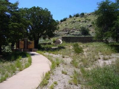
Why Put A Prison On A Mountain?
Honor Camp prisoners built the Mt. Lemmon Highway
In the early 20th century, the only road to Mt. Lemmon began at the town of Oracle and snaked up the north face of the mountain.
Construction . . . — — Map (db m83017) HM
On Broderick Street, on the right when traveling east.
Dedicated in the spring of 1863, this building served as a temple of worship for 10,000 Chinese then living here. Funds for its erection and furnishings were provided by the Emperor and Empress of China and local Chinese labor built the structure. . . . — — Map (db m100599) HM
On Birds Way east of South Main Street (California Highway 49), on the left when traveling east.
This building, once owned by Sam Choy, is the only building remaining from a large Chinese settlement here in early Gold Rush days. Now owned by the City of Angels Camp. — — Map (db m31889) HM
The Chinese community was an early and significant element of the population of Kern County.
Chinese immigrants contributed to the social, economic and industrial growth of Kern County by mining, farming, building railroads, and owning . . . — — Map (db m25318) HM
On Woodford-Tehachapi Road, 3.2 mi E of Keene exit, on the left when traveling east.
From this spot may be seen a portion of the world-renowned “Loop.” It was completed in 1876 under the direction of William Hood, Southern Pacific Railroad Engineer. In gaining elevation around central hill of loop a 4000 foot train will cross 77 . . . — — Map (db m134430) HM
On this centennial we honor over three thousand Chinese who helped build the Southern Pacific Railroad and the San Fernando Tunnel. Their labor gave California the first north-south railway, changing the state’s history. — — Map (db m133729) HM
The courageous work done on the San Fernando Tunnel culminated
in the Southern Pacific Railroad's extension to Southern California
in 1876. Thousands of immigrants from China were recruited to
work on this connection between San Francisco and . . . — — Map (db m234711) HM
On this exact site (or hereabouts) 100 years ago, Clamper Charles Crocker drove a spike of pure California gold, completing the Southern Pacific Railroad link between San Francisco & Los Angeles, Queen of Counties. — — Map (db m133821) HM
On Avenue 12 at Road 28¼, on the right when traveling west on Avenue 12.
The Central Pacific Railroad later Southern Pacific,
neared the village of Arcola in the Alabama Colony
in 1872 and as it was being built mainly with Chinese
labor established near here a Chinese camp of 2,500
men. Leland Stanford named the . . . — — Map (db m147956) HM
On Avenue 12 at Road 28¼, on the right when traveling west on Avenue 12.
This one-acre cemetery was created in 1872 by and for the 2,500 Chinese laborers who were building the Central Pacific, later named Southern Pacific, railroad south from Sacramento. A tiny town, mostly tents was established beside the tracks . . . — — Map (db m197261) HM
In 1775, the packet San Carlos, first known Spanish ship to enter San Francisco Bay, anchored in this cove while her commander, Lieut. Juan Manuel de Ayala, directed the first survey of the bay. Ayala named this island Isla de los Angeles. . . . — — Map (db m143405) HM
In 1979, local restaurant owner "Trader" Vic Bergeron donated this monument in recognition of the contributions of Chinese immigrants to America. Originally located at the site of the former Asiatic Dining Hall, it was relocated to this overlook in . . . — — Map (db m91809) HM
On Chinatown Main Street at Kow Street, on the right when traveling east on Chinatown Main Street.
One of the earlier Gold Rush buildings, and one of the last adobe structures left, this general store was established and operated by the Chinese from 1851 until 1926.
Named after it’s original owners Mow Da Sun and his son, Sun Kow, this store . . . — — Map (db m46366) HM
Near Lighthouse Road near Point Cabrillo Drive, on the left when traveling north.
Our Captain's voice boomed above the roar of the surf. "Heave about! Turn the ship!"
With a mighty jolt a rock took our rudder and punched a hole in her hull. The Frolic was sinking and none of us knew how to swim! Captain Faucon, bless . . . — — Map (db m96476) HM
California State Landmark #927
C.A. 1854
[California Registered Historical Landmark description states: One of the oldest of California's Chinese houses of worship in continuous use, the temple may date back as far as 1854, though its . . . — — Map (db m143483) HM
On North Bloomfield Road at Relief Hill Road, on the left when traveling east on North Bloomfield Road.
This picnic area, sponsored by Wm. Bull Meek-Wm. Morris Steward Chapter Number 10, E Clampus Vitus, is for the enjoyment of all. The redwood lumber for the tables came from Nevada City's Christmas Tree, a Sequoiadendron Giganteum and continues to . . . — — Map (db m857) HM
Near Old Donner Summit Road (Pacific Crest Trail), 0.5 miles south of Donner Pass Road, on the right when traveling south.
Beneath this plaque the first transcontinental railroad traversed the mighty Sierra Nevada range. The 1659 foot long summit tunnel took over 15 months of Chinese muscle and sweat to build. The Chinese painstakingly hand drilled, then blasted the . . . — — Map (db m95506) HM
On Hobart Mills Road at California Highway 89, on the right when traveling east on Hobart Mills Road.
This Monument Marks the Townsite of
Hobart Mills
California
A logging and lumber enterprise
of sixty-six years life in
the Sierra Nevada Mountains
It Commemorates and Honors its Founder
Walter Scott Hobart
1839 - 1892 . . . — — Map (db m129935) HM
Water from the Santa Ana River was largely responsible for the transformation of this arid valley into productive agricultural land. Irrigation companies in Orange County were in operation as early as the 1860s. The two largest were the Santa Ana . . . — — Map (db m59529) HM
So named because of its location on the Bloomer Ranch, it remains virtually unchanged since its original construction in 1864. The overwhelming task of construction was undertaken by the diligent, hard working efforts of a small band of Chinese . . . — — Map (db m93971) HM
Auburn’s original joss house (dedicated February 1909) was located directly across Sacramento Street. After the August 25, 1921 fire that destroyed most of Chinatown, a building was erected here that later became home to the Ling Ying Association. . . . — — Map (db m43696) HM
On State Highway 174, on the right when traveling east.
View of Cape Horn Promontory
North Fork American River Canyon
Dedicated to the memory of thousands of Chinese who worked for Charles Crocker on the Central Pacific Railroad. They were lowered over the face of Cape Horn Promontory in wicker . . . — — Map (db m14437) HM
About 1000 feet from this location is the track of the Transcontinental Railroad. In 1865 thousands of Chinese in Kwantung Provence China were recruited to work on this great connection between the East and West Coast . This monument is dedicated to . . . — — Map (db m48856) HM
In the 1850's, Horatio Gates Livermore and later his sons, Horatio P. and Charles E. pioneered the development of ditches and dams on the American River for industry and agriculture. One historic result was Folsom Power House, which began . . . — — Map (db m706) HM
This sacred ground is one of three revered cemeteries * Young Wo, Sam Yup-Sze Yup, and Hakka * that served the Chinese community once located just north of here. One cemetery vanished during gold dredging activites; Only the Young Wo and Sam Yup-Sze . . . — — Map (db m16243) HM
On Main Street, on the right when traveling south.
This building dates from 1927 when it was rebuilt after a fire in 1926. The upper floor served the Chinese population as a center for religious and social activities.
The Toy family operated a store two doors west called The Quong Wo Sing Co. . . . — — Map (db m18271) HM
On Main Street, on the right when traveling south.
In memory of the industrious Chinese pioneers of California whose strength and sacrifice helped build the transcontinental railroad, construct the levees of the Sacramento San Joaquin Delta, and develop agriculture in the Central Valley. With . . . — — Map (db m18234) HM
On Seacliff Avenue near End of Seacliff, on the right when traveling west.
Since Gold Rush times, this cove was used as a campsite by many of the Chinese fishermen who worked in and around San Francisco Bay. Their efforts to supply the needs of a young city helped establish one of the area's most important industries and . . . — — Map (db m52925) HM
On New Brighton State Beach Parking Lot, 0.4 miles south of McGregor Drive, on the left when traveling south.
During the 1870's and 1880's, a small village constructed of scrap lumber and driftwood was erected at the base of these cliffs. Known as China Beach, or China Cove, it was established by Chinese fishermen who set their nets by boat and then hauled . . . — — Map (db m19881) HM
On Cloverdale Road, on the left when traveling south.
The townsite is located along Cloverdale Rd. for 0.7 of a mile. Established in 1849, the town grew quickly to 1,500 residents, including 600 Chinese closeby. The Hardscrabble mine began operations in 1853, served by the Dry Creek Tunnel and Fluming . . . — — Map (db m89136) HM
Near Kentucky Mine Road, 0.1 miles west of Highway 49.
This monument is placed to honor the early Chinese people of Sierra County who gave so much of their labor to the settlement of the West and this Gold Country. Their contribution in the building of the many roads, railroads, walls, ditches, and . . . — — Map (db m21896) HM
Birthplace of California wine. Founded in 1857 by Colonel Agoston Haraszthy, father of state’s wine industry. Limestone tunnels were dug into the hillside and vineyards were also established. Haraszthy toured Europe in 1861 to gather the cuttings . . . — — Map (db m80732) HM
Mexican land grant. 11 Sq. leagues, - 48,887 acres - made to Francisco Rico and A. Castro on Dec. 29, 1843 by Gov. Micheltorena. Patent signed by Pres. A. Lincoln on Jan. 21, 1863. Abraham Schell bought 3½ leagues in 1863 and with George H. . . . — — Map (db m42103) HM
On California Route 120, 0.3 miles east of Sonora Road, on the right when traveling west.
Picturesque mining center and trading post, 1849, once called Dentville. Early ferry to the southern mines; county seat 1862-72; rare wooden covered bridge reputedly designed by U. S. Grant, brother-in-law of the Dent brothers, 1854; old flour mill, . . . — — Map (db m178065) HM
On Trinity Lake Boulevard (California Route 3), on the right when traveling east.
In the year 1854 on this site two belligerent Chinese Tongs fought a pitched battle, 2000 participated, 26 lost their lives, and many were wounded. — — Map (db m56084) HM
This building, with its rammed earth wall was constructed by early Chinese settlers.
On January 17, 1910, it was purchased by the Weaverville Fire District and was their fire station until 1949.
In 1979, the local fire district, with . . . — — Map (db m56020) HM
This mine was originally known as the Oregon Mountain group of claims, first operated about 1862. In 1892 the mine was purchased by the La Grange Hydraulic Gold Mining Company which brought water from Stuart's Fork through 29 miles of ditch tunnels . . . — — Map (db m32635) HM
On Main Street (California Route 3 / 229), on the right when traveling north.
Chinatown business district was centered in this area. On September 10, 1874, fire destroyed everything from the corner of Highway 3 & Main Street to the Pacific Brewery, except four adobe buildings. Again, on September 30, 1905, fire destroyed all . . . — — Map (db m56027) HM
Near Main Street (California Route 3 / 229), on the right when traveling south.
Hundreds of Chinese miners came to the Weaverville area in the 1850’s and prospered despite hardships, discrimination and tax on foreign miners. The first house of worship burned in 1873; the Chinese continued their religious traditions in the . . . — — Map (db m56086) HM
On Highway 120 at Main Street, on the left when traveling west on Highway 120.
Reportedly founded about 1849 by group of Englishmen who employed Chinese as miners. Much surface gold found on hills and flats. Headquarters for stage lines in early 1850’s, and for several California Chinese mining companies. First Chinese tong . . . — — Map (db m906) HM
Near Big Oak Flat Road (State Highway 120), on the left when traveling east.
In 1859 a wooden suspension flume 2200’ long was constructed across this valley by G.W. Holt and August Conrad as a link in the Golden Rock Ditch system which conveyed the water of the South Fork of the Tuolumne River to the mining areas of . . . — — Map (db m53274) HM
Dedicated March 21, 1880, this building replaced the first temple built nearby in the early 1850s. It has been a Chinese community project since 1866, serving as a meeting hall, court, school, and place of worship. In this 'Palace of Many Saints,' . . . — — Map (db m11758) HM
The close proximity of the gold mines and the railroad construction contributed to Marysville’s large Chinese population in the mid to late 1880’s. When those activities diminished, the Chinese worked in various occupations, many as laborers . . . — — Map (db m65965) HM
On Tahoe Boulevard (Nevada Route 28) 0.2 miles north of Ponderosa Ranch Road, on the right when traveling north.
Located on the mountain above are the remnants of the "Great Incline of the Sierra Nevada." Completed in 1880, this 4,000 foot long lift was constructed by the Sierra Nevada Wood and Lumber Company. A unique steam-powered cable railway carried . . . — — Map (db m94306) HM
On Windmill Road near Campbell Street, on the left when traveling south.
Chinese were prominent working on railroads & gold mines in Baker County. The Baker City Chinatown was located by Powder River on Auburn Avenue where a Joss House was built in 1883. Chinese gardens on the east bank of Powder River between . . . — — Map (db m108158) HM
On Forest Road 73, 2.2 miles north of County Road 24, on the right when traveling north.
Center Panel:These Chinese Miners Must Have Felt Like Sysyphus Pushing a Large Rock Uphill Forever, as in Greek Mythology.
The backbreaking labor of stacking and re-stacking sixteen acres of rocks here at the Ah Hee . . . — — Map (db m106776) HM
Near Ing-Hay Way north of NW Canton Street, on the left when traveling north.
Has Been Designated a
National Historic Landmark
This property possesses national significance
in commemorating the history of the
United States of America
Kam Wah Chung Company Building is the best and earliest known . . . — — Map (db m112884) HM
Welcome to Kam Wah Chung
In 1890 you would be standing in the middle of a bustling Chinatown.Businesses and homes all around you, the temple in front, and Kam Wah Chung- the core of the community- would be to your left. Why is it the only . . . — — Map (db m112887) HM
(The text of this marker is in English, Sahaptin (Nez Percé), and Chinese)
Site of the 1887 massacre of as many as 34 Chinese gold miners.
No one was held accountable.
Celmen Waptamaawnin' Toqooxpa . . . — — Map (db m138409) HM