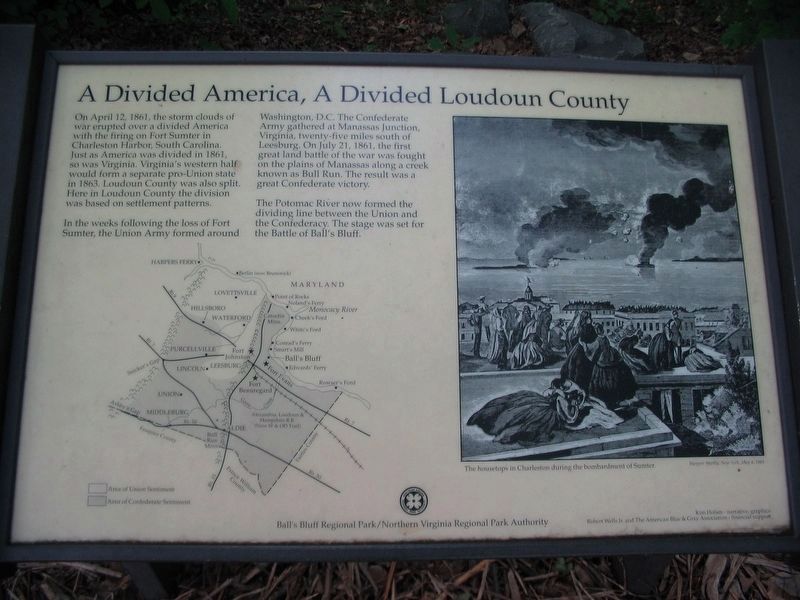
On April 12, 1861, the storm clouds of war erupted over a divided America with the firing on Fort Sumter in Charleston Harbor, South Carolina. Just as America was divided in 1861, so was Virginia. Virginia's western half would form a separate . . . — — Map (db m168035) HM
On April 12, 1861, with the firing on Fort Sumter, America went to war with itself. Just as the country was divided, so were Virginia and Loudoun County. The western portion of Virginia became the separate state of West Virginia in 1863. Here in . . . — — Map (db m168049) HM
Ball’s Bluff is the only battlefield on which a United States senator was killed in combat. Edward Dickinson Baker, senator from Oregon, was also a colonel and one of Brig. Gen. Charles Stone’s three brigade commanders. Baker was a long-time friend . . . — — Map (db m168045) HM
Among the Union casualties here at Ball's Bluff was U.S. Senator, Colonel Edward D. Baker, boyhood friend of Abraham Lincoln. Baker was a former Congressman from Illinois, a brilliant lawyer and orator, veteran of the Mexican War and sitting U.S. . . . — — Map (db m168038) HM
The twenty-five graves here in one of America’s smallest national cemeteries contain the partial remains of 54 Union soldiers killed at the Battle of Ball’s Bluff, October 21, 1861. All are unidentified except Pvt. James Allen of Northbridge, . . . — — Map (db m194381) HM
Ball's Bluff is a 600 yard long shale and sandstone cliff. It rises up a shallow bell curve from two ravines approximately 300 yards north and south of where you are standing. At this point, it is about 100 feet high, though just to the north . . . — — Map (db m150419) HM
The 25 graves here in America's third smallest national cemetery contain the partial remains of 54 Union soldiers killed at the Battle of Ball's Bluff, October 21, 1861. All are unidentified except Pvt. James Allen of Northbridge, Massachusetts, . . . — — Map (db m168050) HM
The Battle of Ball’s Bluff was the result of a mistake. The previous evening, Capt. Chase Philbrick, Co. H, 15th Massachusetts, led a small reconnaissance patrol across the river to determine the results of some earlier Confederate troop movements. . . . — — Map (db m157576) HM
In 2004, Ball's Bluff Battlefield Regional Park began a restoration project on the battlefield where you stand today. The objective of the effort is to return about 12 acres of the battlefield to its approximate appearance in 1861. First hand . . . — — Map (db m150412) HM
The carriage house was used for storage of house drawn carriages and other equipment. This building was constructed in the 1880s and was in use until the 1930s. After horse drawn carriages were no longer commonly used, the building was used as a . . . — — Map (db m7831) HM
At 582 feet, Clarkes Gap, up the hill to your left, was the highest point on the Washington & Old Dominion Railroad. The stone bridge dates from the 1870s, when the tracks were completed to Clarkes Gap. The station stood on the site where you are . . . — — Map (db m2031) HM
Enslaved Africans were first brought to what would become the United States in 1619 and by the early 1800s the system of slaveholding was entrenched in the U.S., mostly in the Southern states. While most Northern states had banned owning people . . . — — Map (db m197010) HM
The Washington & Old Dominion Railroad switched from electric to diesel power during World War II. In 1941-42 the railroad bought its first three diesel-electric engines. Each General Electric engine had 380 horsepower and weighed 44 tons. Later . . . — — Map (db m2111) HM
Electrification arrived in 1912, after the Great Falls & Old Dominion Railroad and the Southern Railway’s Bluemont Branch were consolidated into the Washington & Old Dominion Railway. The new owners brought modern interurban trolley cars. Wire . . . — — Map (db m2107) HM
When Temple Hall Farm was established in 1812, the house and farm buildings of the time were likely built with Black enslaved workers. Enslaved workers were held in bondage there for the next fifty years to provide free labor for the property . . . — — Map (db m197019) HM
In winter this building was filled with ice cut from the Potomac River. The tick stone walls and many layers of straw provided sufficient insulation to preserve a supply of ice for summer use. When the family needed ice, large chucks were retrieved . . . — — Map (db m7836) HM
Lieutenant Colonel Walter H. Jenifer commanded the 300-man cavalry force in Colonel Nathan “Shanks” Evan’s Confederate brigade. Jenifer had some 70 troopers with him at Ball’s Bluff, including portions of the Chesterfield Light Dragoons, . . . — — Map (db m2213) HM
Leesburg’s first railroad depot opened here in 1860 to accommodate passengers, mail, express packages, and freight. All but the freight operations were moved west to King Street in 1887 when the new passenger station opened. An industrial area known . . . — — Map (db m2109) HM
When the Alexandria, Loudoun, & Hampshire Railroad (later W&OD) arrived on May 17, 1860, Leesburg realized a dream. A local newspaper praised the railroad, which “throws us within an hour or two’s ride of the cities of the seaboard, and opens . . . — — Map (db m2110) HM
Red Rock Wilderness Overlook Regional Park is a 67-acre mostly wooded area situated along the Potomac River on the outskirts of Leesburg. Frances Speek donated a portion of the property to the Northern Virginia Regional Park Authority in 1978. The . . . — — Map (db m7820) HM
Henry and Anne Harrison purchased the land that is now Rust Sanctuary in 1909 and built the Manor House. William and Mary Rust bought the property in 1929, renovating portions of the house, adding the front and rear porches and a new grand . . . — — Map (db m130063) HM
Temple Hall was the home of William Temple Thomson Mason, son of Thomson Mason of Raspberry Plain and nephew of George Mason, author of the Virginia Declaration of Rights. The house was constructed about 1810 and was the centerpiece for the farm . . . — — Map (db m106399) HM
What are Heritage livestock breeds and why are they important? Heritage livestock breeds are old breeds that were created before the onset of industrial agriculture. Industrialization of agriculture has greatly reduced the number of variety of . . . — — Map (db m12956) HM
On the night of October 20, 1861, a small Federal scouting party crossed the Potomac River from Maryland to determine whether recent troop movements indicated a Confederate withdrawal from Leesburg. Advancing inland from Ball’s Bluff, the . . . — — Map (db m157212) HM
On the night of October 20, 1861, a small Federal scouting party crossed the Potomac River from Maryland and made its way to the crest of a sheer cliff known as Ball's Bluff. The scouts found the bluffs undefended and continued up this path . . . — — Map (db m168043) HM
The Secession Crisis
Nov 6, 1860: Abraham Lincoln was elected as the 16th US president, defeating John Breckinridge, Stephen Douglas, and John Bell.
Dec 20, 1860: South Carolina secedes from the Union.
Jan 3, 1861: Delaware . . . — — Map (db m168037) HM
In 1940, after a succession of owners, the property was purchased by Mr. and Mrs. James H. Symington. The Symingtons set about restoring the house and making improvements to the farm. The Symingtons succeed in restoring the mansion house, making . . . — — Map (db m12955) HM
The Bluemont Branch of the Washington & Old Dominion was not the railroad’s only line. The Great Falls & Old Dominion Railroad arose in 1906 from the vision of two prominent men. Sen. Stephen B. Elkins of West Virginia had prospered through coal, . . . — — Map (db m2106) HM
The historic barns, shown above in a 2009 photograph, were constructed in the early 1900's on a Leesburg farm owned by John Kincaid. The Town of Leesburg purchased the barns and 17 acres of the original farm in 2002. In 2009, the Town determined . . . — — Map (db m197017) HM
The arrival of the railroad in the 1860s spawned new businesses. One such enterprise was the Leesburg Lime Company, which operated at the site where you are now located. In 1868 a local newspaper announced: New Lime Kiln— Messrs. Orr . . . — — Map (db m2108) HM
At the outbreak of the Civil War in spring 1861, Maj.Gen. Robert E. Lee sent orders to Col. Eppa Hunton in Loudoun County. Anticipating Federal seizure of the Alexandria to Leesburg railroad, Lee told Hunton to tear up track, burn bridges, and . . . — — Map (db m136596) HM
The Monacan Confederacy was the largest Native American group in Virginia prior to the arrival of white Europeans, occupying the central part of the state from the Potomac River to the north and south into North Carolina. Captain John Smith . . . — — Map (db m236432) HM
Brigadier General Charles Pomeroy Stone As the overall commander of Union forces at Ball’s Bluff, Stone was a rising star in the Union army at the time of the battle. He became the scapegoat for the defeat. Stone was born September 30, 1824, . . . — — Map (db m157573) HM
Colonel Nathan George “Shanks” Evans Nathan Evans was born in South Carolina in 1824. An 1848 West Point graduate, he was jokingly nicknamed “Shanks” by his classmates because he was knock-kneed. During the next decade . . . — — Map (db m157627) HM
In 1900, the Virginia state legislature passed a law that required separation of races in public spaces. This included schools, restaurants, hotels and public transportation—which at that time was primarily the use of trains. This was nicknamed . . . — — Map (db m214390) HM
This Is Temple Hall!
Discover Loudoun County's agricultural roots on a working farm at Temple Hall Farm Regional Park in Leesburg, Virginia. Home of the popular Fall Festival and Corn Maize, visitors can meet heritage breed farm . . . — — Map (db m197006) HM
The 100-ft wide W&OD has been called "the skinniest park" in Virginia. But it is also one of the longest parks, 45 miles of paved trail for walking, running, cycling and skating and more. Built on the roadbed of the former Washington & Old Dominion . . . — — Map (db m143133) HM
Standing over 6'4" and wearing a full red beard, Clinton Hatcher was a memorable figure. Despite his Quaker upbringing, he joined Company F of the 8th Virginia at the beginning of the war and became the regimental color bearer. This combined with . . . — — Map (db m2243) HM
The two-chambered granary was used for storing threshed grain until it was either sold or consumed. The presence of two chambers indicates that the owner could grow two different crops and store them simultaneously. Grain was often transported . . . — — Map (db m7832) HM
The Federals crossed three pieces of artillery to Ball’s Bluff. Two mountain howitzers from the 2nd New York State Militia, detached under Lt. Frank French of Battery I, 1st U.S. Artillery, occupied this area for much of the afternoon. A 12-pdr . . . — — Map (db m157629) HM
Three pieces of artillery were successfully conveyed across the Patomac and put into action at Ball's Bluff. Upon his arrival, Colonel Milton Cogswell of the 42nd New York Infantry was placed in charge of the artillery. Two mountain howitzers of . . . — — Map (db m168061) HM
At Temple Hall, we are dedicated to practicing and preserving the agricultural tradition of Loudoun County. This agricultural world is part of all our lives, from the experiences of past generations to the food on our plates today. Join us as . . . — — Map (db m197009) HM
The well house was constructed of poured concrete and was used for storing water on the farm. One room housed a pump, which drew water from a shallow well outside. The second room housed a cistern that was used for storing water after it had been . . . — — Map (db m7834) HM
The artillery piece before you, a replica of a 12-pounder (4.62 inch) Napoleon, sits along a line where two Confederate batteries from Virginia were rapidly put into position facing east toward Middleburg on the early morning of June 19, 1862. . . . — — Map (db m134768) HM
The stone home beside you, built in stages beginning in the mid-18th century, was like many buildings in this section of Virginia—old by 1863 (the oldest part facing the turnpike). It was owned then by the Barton family—Maryland . . . — — Map (db m134766) HM
In 1863, the Ashby’s Gap Turnpike followed the east-bound lanes of today’s Route 50 that you see before you. Stone walls with two wooden rails on top (“stone fences”) lined both sides of the turnpike here along the crest of Mt. . . . — — Map (db m134769) HM
On a day that promised “scorching” temperatures, the Union attack in the Battle of Middleburg began about 6:00 a.m. The 4th Pennsylvania Cavalry, supported by the 16th Pennsylvania and 10th New York, led the advance. The Southern pickets . . . — — Map (db m134767) HM
Under pressure to drive the Southern cavalry through Ashby’s Gap and thereby locate General Robert E. Lee’s Army of Northern Virginia, Union General Alfred Pleasonton had determined to attack on June 19th along two fronts. General David Gregg’s . . . — — Map (db m134771) HM
Johann August Heinrich Heros von Borcke stepped ashore in Charleston, South Carolina on May 24, 1862, having run the Union Navy’s blockade on a rebel blockade runner. He presented an imposing figure—muscular, standing 6’3” and weighing . . . — — Map (db m134770) HM
In its heyday, Paeonian Springs attracted folks such as those men gathered for a raccoon hunt sponsored by The Washington Post in October 1912. The station shown at right stood where the three-sided shelter stands today. Two things happened . . . — — Map (db m2903) HM
Located on the scenic Potomac River, Algonkian Regional Park is the perfect place for an afternoon of fun in the sun, a family vacation or even your wedding. This amazing 838-acre park features an array of activities, a perfect crossroads where . . . — — Map (db m197949) HM
The trail ends here but the story does not. The founders of the Alexandria, Loudoun, & Hampshire (later the W&OD) sought to rival the Baltimore & Ohio Railroad for the coal of West Virginia and the trade of the Ohio Valley. By 1900 the railroad . . . — — Map (db m24307) HM
Electrification arrived in 1912, after the Great Falls & Old Dominion Railroad and the Southern Railway’s Bluemont Branch were consolidated into the Washington & Old Dominion Railway. The new owners brought modern interurban trolley cars. Wire . . . — — Map (db m19330) HM
The tracks are long gone, but Purcellville's train station still occupies the ground it has stood on since 1904. It replaced a depot built at about the same time that the railroad arrived in 1874 and accommodated passengers, mail, and freight. The . . . — — Map (db m238281) HM
The railroad that became the Washington & Old Dominion was born in Alexandria in response to the competition in shipping posed by the port in Baltimore, which was served by the Baltimore & Ohio Railroad. The B&O was diverting farm produce from the . . . — — Map (db m19331) HM
The 100-foot-wide Washington & Old Dominion Railroad Regional Park (W&OD Trail) features a 45-mile asphalt trail for walking, running, skating, bicycling and other activities and a 33-mile, parallel, gravel bridle path for horseback riding and . . . — — Map (db m214369) HM
In 1958 the federal government began construction of a new international airport near Chantilly, Virginia. The Washington & Old Dominion Railroad, whose freight business had been on the decline, enjoyed a resurgence of activity. Cement, stone, . . . — — Map (db m20281) HM
By 1967, when the photograph below was taken, Sterling had grown from a railroad stop known as Guilford to a large residential development. Beginning in 1860, the station served local farmers. Trains carried grain, produce, and dairy products to . . . — — Map (db m20146) HM
158 entries matched your criteria. Entries 101 through 158 are listed above. ⊲ Previous 100