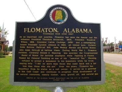
On Sidney E Manning Blvd (U.S. 29) at Houston Street, on the right when traveling north on Sidney E Manning Blvd.
Front As railroads were reconstructed following the Civil War, a junction of north-south and east-west lines was established along the Alabama-Florida border near the confluence of Big Escambia Creek and the Conecuh-Escambia River. A . . . — — Map (db m47484) HM
On Hospital Road 1.4 miles north of East Water Street (Route 81), on the right when traveling north. Reported missing.
The Tuskegee Veterans Administration Hospital (VA), established in 1923, is significant as the first VA hospital in the nation to be administered by an all African American medical staff.
After WWI, African American veterans found it difficult . . . — — Map (db m101900) HM
On Coolidge Dam Road (Route 3) 9 miles south of US 70 (U.S. 70), on the right.
Built by
The United States of America
Department of Interior
Bureau of Indian Affairs
Irrigation Service
Calvin Coolidge
President of the United States of America
Roy O. West Secretary of the Interior • Hubert Work Secretary of . . . — — Map (db m81530) HM
The beacon on top of the Los Angeles City Hall was turned on by President Calvin Coolidge from the White House during the city hall dedication ceremonies April 26, 1928. The light was gratefully dedicated to Charles A. Lindbergh for his contribution . . . — — Map (db m117175) HM
On Lake Street at High Street, on the right when traveling north on Lake Street.
The Original Meetinghouse
The First Church of Coventry stood on the town green facing Lake Wamgumbaug and also served as the town meeting house. The structure was built in 1716, though a full completion with furnishings did not come until 1738. . . . — — Map (db m142437) HM
On Lake St at Cross Street, on the left when traveling south on Lake St.
In grateful memory
Of those men of Coventry who gave
themselves unreservedly in the hour
of their country’s need
Among them was Nathan Hale
all might have echoed his immortal words
“I only regret that I have but one life to lose . . . — — Map (db m140941) WM
On Highland Avenue at Sunnyside Avenue, on the right when traveling north on Highland Avenue.
Plymouth Rock does not mark a beginning or an end. It marks a revelation of that which is without beginning and without end. A purpose shining through eternity with a resplendent light undimmed even by the imperfections of men and a response an . . . — — Map (db m24216) HM
On Connecticut Avenue Northwest at DeSales Street Northwest, on the right when traveling north on Connecticut Avenue Northwest.
This hotel opened February 18, 1925. Its first major event was the inaugural ball of President Calvin Coolidge. It has entertained every President since and has been the residence of a number of Vice Presidents, Cabinet members, Supreme Court . . . — — Map (db m8955) HM
On Connecticut Avenue Northwest south of Dupont Circle Northwest, on the right when traveling south. Reported permanently removed.
Images Courtesy Of: Library of Congress, Prints and Photographs Division • DC Public Library, Washingtoniana Division • Heurich House Museum • Women's National Democratic Club Archives • Michael Cianciosi Private Collection, Potomac Bottle . . . — — Map (db m110851) HM
On Pennsylvania Avenue Northwest at 9th Street Northwest, on the right when traveling east on Pennsylvania Avenue Northwest.
The National Archives, keeper of the nation's founding documents and most important federal government records, occupies this important spot halfway between the Capitol and the White House. Before the Archives building was constructed, federal . . . — — Map (db m57217) HM
Near 14th Street Northwest (U.S. 1) south of Pennsylvania Avenue Northwest, on the right when traveling north.
This monument was erected by public subscription in accordance with the joint resolution of Congress of December 16, 1927. Signed by President Coolidge March 2, 1929, in memory of
Oscar S. Straus
1850 - 1926
Author . . . — — Map (db m9159) HM
On Vermont Avenue Northwest at O Street Northwest, on the right when traveling south on Vermont Avenue Northwest.
Born on July 10, 1875, in Mayesville, South Carolina, Mary McLeod Bethune was the daughter of sharecroppers. After attending Scotia Seminary in North Carolina she founded Daytona School for Negro Girls which became Bethune-Cookman College. A . . . — — Map (db m17502) HM
On Wisconsin Avenue Northwest north of Quebec Street Northwest, on the left when traveling north.
Friendship was the country estate for two generations of the McLean family. The English style manor house “Eden Bower” was built around 1800 by British Col. Richard Pyle. Pyle was succeeded by Georgetown University, which used the . . . — — Map (db m152176) HM
On 16th Street Northwest just north of Harvard Street Northwest, on the left when traveling north.
Today's 16th Street from the White House to Silver Spring, Maryland is one of the city's key gateways. But through the 1890s it jogged left where Mt. Pleasant Street runs today and then dead-ended at the edge of today's Rock Creek Park. . . . — — Map (db m130861) HM
On 16th Street Northwest north of Irving Street Northwest, on the left when traveling north.
Beginning in the late 1950s, the community leadership of Mount Pleasant changed from the exclusive Citizens Association to an array of new players. Mount Pleasant Neighbors Association was the first alternative group. It presented festivals and . . . — — Map (db m148598) HM
On Pennsylvania Avenue Northwest at 14th Street Northwest (Highway 1), on the right when traveling west on Pennsylvania Avenue Northwest.
Site of
Joshua Tennison's Hotel 1818. John Strother 1821. Basil Williamson 1824. Frederick Barnard 1828. Proprietor of Mansion Hotel, Azariah Fuller American House 1833. City Hotel 1843. Willard's Hotel 1847-1901.
Distinguished Guests . . . — — Map (db m6618) HM
On E Street Northwest west of 15th Street Northwest, on the left when traveling west. Reported permanently removed.
At 5:00 p.m. on Christmas Eve, 1923, President Calvin Coolidge walked from the White House to the Ellipse and “pushed the button” to light the first National Christmas Tree. A crowd of 3,000 witnessed the inaugural lighting of the 48-foot, cut . . . — — Map (db m130403) HM
Near E Street Northwest west of 15th Street Northwest, on the left when traveling west.
The National Christmas Tree has been located at the site in front of you since 1973. Calvin Coolidge was the first president to light the National Christmas Tree on Christmas Eve, 1923. Since that time presidents have continued the tradition in . . . — — Map (db m130405) HM
Near South Capitol Street Southeast at Potomac Avenue Southeast, on the right when traveling north.
Presidential Fans
a. Woodrow Wilson throws out the first pitch on Opening Day, 1916. National Photo Company.
b. Calvin Coolidge and Senators ace Walter Johnson, 1924. National Photo Company.
c. President Herbert . . . — — Map (db m179719) HM
Near Arnold Avenue Southwest 0.1 miles north of Tinker Street Southwest, on the left when traveling north.
[Panel 1]:
Old Bolling Field
1917 - Survey for the site of a military flying field to be used for defense of Washington and for proficiency flying. Captain William "Billy" Mitchell, commander of Army Signal Corps Aeronautics . . . — — Map (db m63896) HM
On North Baker Street at East 6th Avenue, on the left when traveling south on North Baker Street.
After a fire destroyed the community’s Town Hall in 1922, Mount Dora was in need of an auditorium for public assemblies. Despite the hard economic times, construction of the Mount Dora Community Building began in 1929 with funds raised by the . . . — — Map (db m145589) HM
Near Willing Street 0.1 miles west of Caroline Street.
August 1, 1914
Germany Declares War On Russia & France
August 4, 1914
Wilson Declares U.S. Neutrality
May 7, 1915
Germans Sink Lusitania
January 31, 1917
Germany Resumes Submarine . . . — — Map (db m152468) WM
Near Interstate 4 at milepost 95, 1 mile east of Florida Route 434, on the right when traveling west.
The Senator Tree in Seminole County, once the oldest and tallest bald cypress in the U.S., stood for over 3,500 years. A natural landmark for Native tribes and early travelers, it was named in honor of Florida Sen. M.O. Overstreet. In 1929, . . . — — Map (db m311992) HM
On Days Cross Road (County Route 2411) at Cottonhill Road, on the right when traveling east on Days Cross Road.
Here stood the Cotton Hill Male and Female Seminary incorporated by an Act of the Legislature March 6, 1856, but in existence before that time. Professor Norman Flavius Cooledge, uncle of President Calvin Coolidge, who had come to Georgia for the . . . — — Map (db m47103) HM
On Peachtree Street at Ponce de Leon Avenue, on the right when traveling north on Peachtree Street.
Built by Atlanta native, Joseph Gatins and designed by New York Architect, W. L. Stoddard, the Terrace opened October 2, 1911. Over the years most of Atlanta’s famous visitors have chosen the Georgian Terrace Hotel as their temporary home on . . . — — Map (db m47425) HM
On State Highway 21 at East Lake Forest Drive, on the right when traveling east on State Highway 21.
In 1906, at the age of seventy-five, Ezra Meeker began a journey east from his home in Puyallup, Washington, to retrace the route of the Oregon Trail over which he originally traveled in 1852 with his wife and young son. He traveled the route with . . . — — Map (db m118993) HM
On 27th Street 0.1 miles south of Logan Street, on the left when traveling south.
In memory of
Jefferson County Veterans
"The nation which forgets its defenders will be itself forgotten."
Calvin Coolidge
To give a life is a miracle of God
To lose a veteran is an unforgettable memory
Dedicated December 7, . . . — — Map (db m61932) WM
On East Main Street (U.S. 421) west of North Franklin Street, on the right when traveling west.
Note: When this Memorial was documented and photographed (Sunday: 7-17-2011), it was being yet constructed (and/or reconstructed.) There were skids of building material setting about in the parking lot, ground opened, concrete just finished, . . . — — Map (db m45063) WM
On West Park Drive (Business U.S. 24) 0.1 miles west of Dimond Street, on the right when traveling west.
Charles S. Beard •
Edward D. Hoover •
Charles Ambrose Smith •
Homer Glenn Fisher •
Robert McNeil Mayne •
Floyd Stanley Stewart •
Elmer Leroy Fyson •
Garland A. Robbins •
Harry H. Surran •
Carl William Grossman •
Harry Glen . . . — — Map (db m161509) WM
On Main Street (State Road 156) at 3rd Street, on the left when traveling south on Main Street.
Patriot, Ind., native; supervised Hoover Dam construction in Colorado R.; Lake Mead named for him; appointed Director, U.S. Bureau of Reclamation, President Coolidge; served under Presidents Hoover and Roosevelt, top authority on irrigation, . . . — — Map (db m66902) HM
Near Interstate 80 at milepost 119, 1.9 miles east of Ute Avenue (County Road R22), on the right when traveling east. Reported permanently removed.
The fork of the Des Moines and Raccoon Rivers was recognized as an ideal site a military post as early 1834. Fort Des Moines was established in 1843, but was abandoned in 1846 following the treaty whereby the Sauk and Mesquakie Indians relinquished . . . — — Map (db m33004) HM
Near Route 80 at milepost 147, 1.2 miles west of 112 Street NE (County Road S27), on the right when traveling west.
Historic Des Moines
The fork of the Des Moines and Raccoon Rivers was recognized as an ideal site a military post as early 1834. Fort Des Moines was established in 1843, but was abandoned in 1846 following the treaty whereby the Sauk and . . . — — Map (db m33009) HM
A monument to the golden era of rail travel, the Mount Royal Station enjoys a special place in the history of Baltimore and the nation—the home of the Baltimore & Ohio (B&O) Railroad and birthplace of American railroading. The history of the B&O . . . — — Map (db m208442) HM
This historic walk takes you to the Turkey Point Light Station in Maryland's Cecil County. You will find, atop a 100-foot-high bluff, an 1833 tapering conical stucco-covered brick tower and a 1913 cement oil house. This Lighthouse is 31_1/2 feet . . . — — Map (db m147628) HM
On Main Street at Strong Avenue, on the right when traveling south on Main Street.
This building is a fine example of Classical Revival style popularized by the 1893 Chicago World's Fair. Calvin Coolidge 30th President 30th President of the United States, practiced law here from 1898 to 1918 with the firm of Coolidge and Hemenway. — — Map (db m230491) HM
Near Main Street (Massachusetts Route 10) at Masonic Street, on the right when traveling east.
By the mid 19th century the simple elegance of Northampton's buildings began to give way to the tastes and fashions of a new era of commercialism. William Fenno Pratt, who designed many of the Victorian buildings on Main Street, conceived of the . . . — — Map (db m138436) HM
Near Main Street (Massachusetts Route 10) at Masonic Street, on the right when traveling east.
Commercial development along upper Main Street followed the industrial expansion spurred by the Civil War. As Northampton became a manufacturing center, its business district expanded to accommodate a growing and changing population. In the 1860s . . . — — Map (db m138438) HM
On West Pershing Road near Main Street, on the left when traveling west.
On this spot on the first day of November One Thousand Nine Hundred Twenty One during the Third Convention of the American Legion in the presence of the associated war leaders Ferdinand Foch Marshal of France Armando Diaz General of the Army of . . . — — Map (db m44366) HM WM
The Liberty Memorial, one of Kansas City’s most recognizable landmarks, is the only major memorial in the United States dedicated to World War I.
In late 1919, when American spirit was at its peak following “the war to end all wars,” . . . — — Map (db m43188) HM
On Local Route 63 0.1 miles north of Old Chesterfield Road, on the right when traveling north.
Born October 11, 1872, in a modest cottage
1.7 miles southeast of here on Horseshoe Road,
Stone graduated from Amherst College and
Columbia Law School, returning to the latter
as Dean, 1910-1924. Attorney General in President Coolidge’s . . . — — Map (db m74560) HM
On Boardwalk just east of South Iowa Avenue, on the right when traveling west.
Former Ritz Carlton Hotel opened during the "Roaring Twenties" on June 24, 1921 as one of Atlantic City's Grand Hotels.
Designed by the architectural firm of Warren and Wetmore and constructed at a cost of $6 million.
During WW2 the . . . — — Map (db m208348) HM
On North 5th Street at Pearl Street, on the right when traveling north on North 5th Street.
Although efforts to build a bridge connecting Camden with Philadelphia began in 1818, it wasn't until 1926 that a bridge was completed. Ferries provided transportation across the Delaware River as early as the 1680's and contributed to the growth . . . — — Map (db m190722) HM
Plaque 1: This tower marks the site of the experimental laboratory built by Thomas Alva Edison, born Milan, Ohio, February 11, 1847. The laboratory structure occupied by the inventor from 1876 to 1886, was transported in 1929 by his friend . . . — — Map (db m33292) HM
On Bloomingdale Avenue (New York State Route 3) at Depot Street, on the right when traveling west on Bloomingdale Avenue.
Saranac Lake has been the “Gateway to the Wilderness” since the 1850s. With the arrival of the railroad came an eclectic assortment of travelers who made history in Saranac Lake. The early 1900s saw Saranac Lake become a fashionable . . . — — Map (db m147496) HM
On East 64th Street at Madison Avenue, on the right when traveling east on East 64th Street.
The lawyer and former New York governor lived here from 1917 to 1921, after losing the 1916 presidential elections to Woodrow Wilson. Hughes served as U.S. Secretary of State during the Harding Administration (1921-23) and the Coolidge . . . — — Map (db m98645) HM
On Memorial Highway (U.S. 64/74) at Arcade Street, on the left when traveling west on Memorial Highway.
In Spring of 1927, this sixty-room hotel was opened simultaneously with the incorporation of the Town of Lake Lure (sister city of Lake Como, Italy) and the completion of the Lake Lure Dam which formed the lake, along with other matching . . . — — Map (db m234194) HM
On North Superior Street 0.1 miles north of Jackson Street, on the left when traveling north.
The Toledo Blade is the city's oldest continuing business. The newspaper was first published on December 19, 1835, during the Ohio-Michigan boundary dispute known as the "Toledo War." The name is derived from that conflict and the famous swords of . . . — — Map (db m121496) HM
Near Delaware Avenue (Ohio Route 423) at Vernon Heights Boulevard, on the right when traveling north.
Warren Gamaliel Harding
Warren Gamaliel Harding was born November 2, 1865, in Blooming Grove, Ohio, to Dr. George Tryon Harding and Phoebe Dickerson Harding. The family moved to the village of Caledonia, and then to Marion.
Harding . . . — — Map (db m219208) HM
Fairhope Elementary School was built in 1925. Calvin Coolidge was president of the United States at the time. The initial building was just 6,111 sq. ft. and the building had additions added in 1938, 1957 (gym) and 1965. Over its 87 years of service . . . — — Map (db m78951) HM
For heroism or extraordinary achievement
while participating in aerial flight.
Established by the Congress on July 2, 1926,
during the Presidency of Calvin Coolidge. — — Map (db m232247) HM WM
For heroism not involving actual conflict
with an enemy of the United States.
Established by the Congress on July 2, 1926,
during the Presidency of Calvin Coolidge. — — Map (db m232250) HM WM
Near Chestnut Street (Pennsylvania Route 66) at West Spruce Street.
First called "Blood's Settlement", and then later Marien, then Marienville, after Marien (Blood) Hunt, daughter of Cyrus Blood, the founder of Forest County. Marienville is located on a flattened ridgeline known as the "Big Level", . . . — — Map (db m138604) HM
On South 6th Street (County Road 2005) at Market Street (County Road 2004), on the left when traveling south on South 6th Street.
"It ought to be commemorated, as the Day of Deliverance by solemn Acts of Devotion to God Almighty. It ought to be solemnized with Pomp and Parade, with Shews, Games, Sports, Guns, Bells, Bonfires and Illumionations from one End of . . . — — Map (db m306738) HM
[South]:
To our military men and women, past and present, your commitment, service and sacrifice will be remembered and appreciated forever.
[North]:
The nation which forgets its defenders will itself be forgotten.
. . . — — Map (db m15389) HM
Near Medary Avenue 0.1 miles north of 8th Street, on the right when traveling north.
In the 1920s, a move to beautify the campus and create a new center for student activities led to construction of the Coolidge Sylvan Theatre and Coughlin Campanile. Trees, shrubs, grassy areas, and vines combined with the theatre's brick and . . . — — Map (db m290616) HM
On West 22nd Street, on the left when traveling west.
Side A
During most of the 19th century, few women completed high school
and only daughters of the privileged or well educated had an
opportunity for a higher education. In 1881 seventeen women met
in Boston, Massachusetts, to discuss . . . — — Map (db m97577) HM
1923 • Colossal sculpture in the Black Hills first suggested by Doane Robinson.
1924 • Gutzon Borglum's first visit to the Black Hills.
1927 • Address by President Calvin Coolidge at Mount Rushmore and first actual drilling.
1929 • Senator . . . — — Map (db m89492) HM
On Nemo Rd 1.2 miles west of Bittersweet Rd, on the right when traveling west.
A one time member of Buffalo Bill Cody's Wild West Show, Madison came to Dakota Territory in 1886 and the history of South Dakota Rodeo began. Russ won the Champion Relay Race in Sioux City, Iowa, in 1907 and then began building his bucking horse . . . — — Map (db m113149) HM
On Roscoe Fitz Road at Sunset Drive (Tennessee Road 82), on the left when traveling east on Roscoe Fitz Road.
Charlie Bowman, Hall of Fame fiddler, vaudeville performer, and writer of Nine Pound Hammer and East Tennessee Blues, toured with the Hill Billies and other music groups, once performing for President Calvin Coolidge. Two daughters, . . . — — Map (db m45590) HM
On North Covington Street near Fancher Street, on the left when traveling north.
This depot was built to serve the Missouri-Kansas-Texas (Katy) Rail Line, which reached Hillsboro in 1881. Completed in 1902, the station features elements of the Eastlake, Victorian, and Prairie styles. Early MKT trains carried materials for the . . . — — Map (db m62900) HM
On Horse Canyon Road, on the left when traveling east.
Woodside
The area's first resident was a local prospector named Henry H. Hutchinson, who settled there in 1881. Other homesteaders arrived the next year and started digging an irrigation canal. Attracted by relatively abundant water and an . . . — — Map (db m131511) HM
On Depot Street near River Street, on the left when traveling north.
“I could not look upon the peaks of Ascutney, Eillington, Mansfield, and Equinox without being moved in a way that no other scene could move me. It was here that I first saw the light of day; here i received my bride; here my dead lie . . . — — Map (db m77057) HM
On Maple Street 0.1 miles west of South Willard Street (U.S. 7), on the right when traveling west.
On Oct. 4, 1905, at 2:30 p.m. in front of the bay window in the parlor of this house, Grace Goodhue married Calvin Coolidge of Plymouth Notch, VT. Calvin Coolidge became President of the United States and Grace served as First Lady from 1923-1929. . . . — — Map (db m75591) HM
Locomotive 220 was the last coal-burning steam ten-wheeler used on the Central Vermont Railway. As a medium-sized engine it moved both freight and passenger trains and became known as the [sic] "The Locomotive of Presidents" for its use on special . . . — — Map (db m109152) HM
The Rail Locomotive No. 220, built in 1915 by the American Locomotive [C]ompany of Schenectady, New York, was the last coal-burning, steam ten-wheeler used on the Central Vermont Railway. As a medium-sized 4-6-0 engine (4 leading wheels, 6 driving . . . — — Map (db m109153) HM
On Messer Hill Road, on the right when traveling west.
This flagpole, which stood for 30 years on the east wing of the State House in Boston, is presented to the Town of Plymouth by the Society of the Sons of the Revolution in the Commonwealth of Massachusetts and dedicated to the memory of Capt. John . . . — — Map (db m105580) HM
Born July 4, 1872 in a house back of store, Calvin Coolidge from 4 years of age lived in the homestead across the road, now owned by the State of Vermont. Here on Aug. 3, 1923 he was inaugurated President and he spent many vacations. In the Notch . . . — — Map (db m74473) HM
Calvin Coolidge Homestead has been designated a Registered National Historic Landmark.
Under the provisions of the Historic Sites Act of August 21, 1933 this site possesses exceptional value in commemorating or illustrating the history of the . . . — — Map (db m62155) HM
On Lee Drive at Lafayette Boulevard (U.S. 7) on Lee Drive.
Dedicated October 19, 1928
by
Calvin Coolidge
President of
the United States
To commemorate
the beginning of work on the
Fredericksburg and Spotsylvania
National Battlefields Memorial,
authorized by act of Congress . . . — — Map (db m33410) HM
On East Stuart Drive (U.S. 221) at New River Trail State Park, on the right when traveling south on East Stuart Drive.
Galax. Much of America’s music was invented in Virginia, and Galax and surrounding communities have long been an epicenter for the keeping of historic sounds and the creation of new ones. Greenberry Leonard lived in the Old Town section of . . . — — Map (db m68284) HM
On Seminary Church Loop (Old U.S. 58) at Cave Springs Road (County Route 622), on the left when traveling north on Seminary Church Loop.
Three men who served in Congress were
born within a one-mile radius of this point
James B. Richmond (1842–1910) was a member
of the House of Representatives from 1879
to 1881 as a Democrat. Campbell Slemp (1839–1907), a Republican, . . . — — Map (db m104896) HM
On 35th Street at Virginia Beach Boardwalk, in the median on 35th Street.
The Virginia Beach Police Foundation, with the generous support of many individuals groups and corporations caused this memorial to be erected to honor the memory of those law enforcement officers who have made the ultimate sacrifice in the line . . . — — Map (db m165138) HM WM
On Wood Avenue West (Alternate U.S. 58) at West 1st Street North on Wood Avenue West.
This museum is located in a mansion built by
lawyer and industrialist Rufus Ayers, Virginia
attorney general in the 1880s.
Newman and her brother, C. Bascom Slemp, former U.S. Congressman and private secretary
to President Calvin . . . — — Map (db m90897) HM
Near North Cascades Highway (Washington Route 20 at milepost 125), 2.5 miles west of Diablo Street, on the left when traveling west.
Transmission lines are a visible link between these remote mountain lakes and densely populated urban areas. Gorge was the first of the Skagit power projects to go on line. On September 17, 1924, President Calvin Coolidge pressed a gold telegraph . . . — — Map (db m129281) HM
On South 3rd Street north of Washington Avenue, on the left when traveling north.
John William Davis was born in Clarksburg on April 13, 1873. Davis served in the United States House of Representatives from West Virginia's First District, was the United States Solicitor General under President Woodrow Wilson, and was the . . . — — Map (db m257195) HM
On May 31, 1928, President Calvin Coolidge accepted former Senator Irvine Lenroot's invitation to spend the summer in the Superior area. Henry Clay Pierce had offered Cedar Island Lodge, part of a 4,000 acre Brule River estate, to serve as living . . . — — Map (db m52127) HM
Near County Highway C north of Interstate 90/94, on the left when traveling north.
The thanks of the Nation is extended through the President, Commander in Chief of the Army and Navy of the United States to the people of The Winnebago Tribe in Wisconsin for their unswerving loyalty and patriotism, the splendid service . . . — — Map (db m37190) HM
On Interstate 90, on the right when traveling south.
Founded only a few years after removal of Native American tribes from the Powder River Basin, the town of Sheridan retains the atmosphere of a bustling late 19th/early 20th century western town. The original downtown was platted in 1882 by John D. . . . — — Map (db m86160) HM
Thomas Mellon was born in this cottage on February 3rd, 1813. It was built by his father and uncle a few years earlier "chiefly by the labour of their own hands" and stood on a Twenty-three acre farm cut out of his grandfather's larger estate. . . . — — Map (db m85967) HM