The US Library of Congress notes that although "the word 'utopia' is often associated with science fiction, utopian communities were a common fixture in nineteenth century America. Incorporating unique religious and social ideals, these communities grew rapidly during the nineteenth century before declining in the early twentieth century."
This series includes markers highlighting communal and utopian societies throughout the world, whether they were religiously focused or secular.
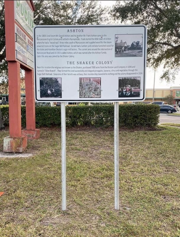
In the 1800s land boom Mr.Gerald Ashton and his brother Mr.Frank Ashton came to the
Narcoosssee English Colony and settled in Runnymede. Frank started the little town of Ashton where he had a "wood rack” three miles south of Narcoossee and . . . — — Map (db m215443) HM
First settlement, 1808-1812,
of a religious society of
celibates known as Shakers.
The four hundred members
of this communal group
occupied 1,300 acres seven
miles west of Carlisle. — — Map (db m226327) HM
What is utopia?
Sir Thomas More in 1516 defined it as a place of perfect political and social systems.
Throughout history, people have sought ways to live "in harmony..." So it was that the town of Harmonic, Pennsylvania was established in 1804 . . . — — Map (db m96074) HM
Location of two attempts at communal living: The Harmonists under Reverend George Rapp, 1814-1825, and the Owenites under philanthropist Robert Owen, 1825-1826. New Harmony remained, an important cultural center for many, years thereafter. — — Map (db m47821) HM
Side One
William Maclure and other intellectuals came to New Harmony 1826 to join Robert Owen's utopian experiment. Maclure established the Workingmen's Institute 1838 to serve as model of self-education for laborers. Operated in various New . . . — — Map (db m47840) HM
The American Institute of Certified Planners
has designated
New Harmony, Indiana (1814-1827)
as a
National Planning Landmark
George Rapp's New Harmony was surveyed on August 8, 1814. Within ten years, the Harmonists created a . . . — — Map (db m96195) HM
In 1780 communal colonists came
from Pennsylvania to Mercer County, Kentucky. In
1784 thirty of the families came
here, purchased 10,000 acres from
Squire Boone. Lived in log fort.
Managed by Abraham Banta, George
Bergen made trustee later. . . . — — Map (db m136247) HM
Organized 1807, as Gasper Society of United Believers in Christ's Second Appearing. Building program started and trade established in textiles, seeds, mill products, and purebred cattle. Peak membership 350; acreage 6,000. Most prosperous period . . . — — Map (db m123415) HM
The cemetery was established soon after
South Union was founded in 1807.
Encompassing six acres of land, the tract
eventually held the graves of nearly five
hundred Shakers who died between
1810 and 1921.
After the village closed in . . . — — Map (db m199270) HM
Built 1869, nine years after the completion of the Louisville and Nashville railroad thru South Union land. Members approved tax to build line thru here, furnished material and constructed depot. Visitors increased and trustees built the hotel, . . . — — Map (db m123413) HM
Designed and built by Dr. Guilford Runyon in the early 1840s for his fiancé Kitty Ferrel who died of cholera. Runyon was an orphan reared by the Shakers at Pleasant Hill until he was expelled after announcing his intention to marry. Noted for its . . . — — Map (db m152936) HM
Shakers hid their horses as CSA Gen. J. H. Morgan's cavalry came this way July 13, 1862. But he forbade command to trespass or molest Shakers out of respect for their religion. Grateful for this good treatment Shakers fed Morgan and his men . . . — — Map (db m218273) HM
Completed by 1839, Lexington-Harrodsburg-Perryville Turnpike (KY 68) ran through center of Pleasant Hill. Road became part of interstate Zanesville (Ohio)-Florence (Ala.) mail stage route. Stages discontinued here by 1877. Turnpike brought the . . . — — Map (db m218275) HM
Shaker Landing At foot of this road is landing purchased by Shakers, 1830. Site made Pleasant Hill busy river port and ferry crossing. Quality Shaker products left here for downriver markets as far away as New Orleans. During Civil War, ferry . . . — — Map (db m218263) HM
Mother Ann Lee and small band of converts came from England to New York, 1774. She was founder of Shakerism in America. Shakerism introduced in Mercer County by Elisha Thomas, Samuel and Henry Banta. After attending a Revival at Concord, Bourbon . . . — — Map (db m218264) HM
Cochranism was the name given to the religious sect led by Jacob Cochran in the years 1816 to 1819, before this charismatic preacher was convicted and imprisoned for four years on charges of “gross lewd and lascivious conduct.” The . . . — — Map (db m55698) HM
has been designated a
Registered National
Historic Landmark
under the provisions of the
Historic Sites Act of August 21, 1935
This site possesses exceptional value
in commemorating or illustrating
the history of the United . . . — — Map (db m118819) HM
Hancock Shaker Village installed this solar photovoltaic (pv) array in December 2009. Here is one sample pv panel for you to examine and touch (it is not connected to the array and will not harm you).
Throughout the Village there are many . . . — — Map (db m118828) HM
The Shakers, perhaps more than any other religious movement, embraced purity of design and consummate craftsmanship in everything they created. These banners represent a sample of the typical and joyful Shaker palette. As you tour this National . . . — — Map (db m118818) HM
Downtown Enfield Village
This village, formerly called North Enfield, grew around mills powered by the Mascoma River. In the 1840s, railroad service and economic investment by the Enfield Shakers laid the foundation for its growth as a mill village . . . — — Map (db m98152) HM
The Enfield Shakers
Founded in 1793, Shaker Village was the 9th of the original Shaker communities established in the U.S. At its peak c.1850 some 300 Shakers lived, worked and worshipped here, practicing equality of the sexes, celibacy, pacifism, . . . — — Map (db m98107) HM
Take opposite road 2.6 miles to the attractive buildings of this Utopian community organized in 1792 in the township of Canterbury. The Shakers established high standards of agricultural efficiency, craftsmanship and domestic skill for their sect . . . — — Map (db m117623) HM
The Dwelling House or "Bell House" contained a kitchen, large community dining rooms, and retiring rooms (bedrooms). At the height of this community, 100 Shakers lived in the main building and the 'T' shaped wing. On its roof in a cupola, hung a . . . — — Map (db m115659) HM
The Brethren's Shop was used by the men and boys for various crafts including shoe making and tinsmithing. The porches and dormers were added in 1930 and the building is now used by Albany County as offices.
A date stone in the basement is . . . — — Map (db m115662) HM
The Shakers stored milk in the creamery to keep it cool. Milk was brought from the barn in large milk cans, which were then kept cool in troughs filled by water diverted from the creek. Later the building was used as a hen house; now it is used . . . — — Map (db m115688) HM
This brick building was used by the ministry elders. Each member of the ministry had to perform daily manual labor such as shoe making or tailoring. Elder Chauncey Copeley a cabinet maker, worked in a wing added to the building in 1850. . . . — — Map (db m115660) HM
By 1920, automobiles had become both necessary and fashionable. The Shakers never hesitated to adopt new technology that would make life easier and more efficient. They built this concrete garage for their Packard automobilies [sic]. — — Map (db m115671) HM
The plants in this garden are some of the herbs used and sold by The Watervliet Shaker Community during the 1800's. The community grew large "Botanical/Physic" gardens and also gathered many wild herbs for use in their business of selling dried . . . — — Map (db m115658) HM
This Meeting House, or Church, was built in 1848 to replace an earlier (1791) and much smaller Meeting House. It demonstrates many typical characteristics of Shaker architecture; double doors, one for men and one for women; a large meeting room . . . — — Map (db m115663) HM
On this location was a large 3 1/2 sto[r]y stone building. Here Shaker Sisters did spinning, weaving, and sewing. Journal entries indicate that Sister Polly wove 3350 Shaker bonnets in this building.
The building was the only stone building . . . — — Map (db m115656) HM
Shaker Creek provided water for both the canning and laundry operations. The first laundry, done on December 12, 1859, used a steam powered washing machine. Albany County used the building for laundry until the mid 1980s. Today it is a workshop. . . . — — Map (db m115674) HM
This 70-acre property was donated to the Mohawk Hudson Land Conservancy by
Dr. Patricia Fox in 2015. Dr. Fox owned the property for over 30 years, and it is one of the last remaining areas of open space in this area of the Town of Colonie. Through . . . — — Map (db m147937) HM
A Canal 1840-1878 The Genesee Valley Canal provided transportation through the Genesee River Valley between the Erie Canal in Rochester and the Allegheny River at Millgrove, southeast of Olean. The Genesee Valley Canal was one of several . . . — — Map (db m207301) HM
On this site the eighteenth and last Shaker community in America was founded in 1836 by members of the Sodus Bay Shaker community. The Shakers, formerly known as the United States Society of Believers in Christ's Second Appearing, were a religious . . . — — Map (db m87748) HM
This is one of several stone gate posts which stood before the buildings of the Middle Family of Shakers near what is now Shaker Boulevard and Lee Road. The post was found under an old cherry tree at that site.
Placed in Shaker Square October 22, . . . — — Map (db m17818) HM
In 1844 the Shakers of North Union, Ohio, built a five-story gristmill on the north side of the Doan Brook Ravine adjacent to this marker. Water from the dam at the west end of the Lower Shaker Lake powered the mill. For many years it served the . . . — — Map (db m11826) HM
Found at the site of the Shaker saw mill foundations on Coventry Road adjacent to Shaker Lake. The saw mill, destroyed by fire, was converted to grain milling in 1886 using this stone from the original Shaker grist mill.
Placed in Shaker Square . . . — — Map (db m11848) HM
This site marks the location of the main dwelling of the East or Gathering Family established for the expressed purpose of gathering souls "out of the world". Here the new converts were "proved awhile" until they convinced the elders and eldresses . . . — — Map (db m10422) HM
In 1822, Ralph Russell, a Connecticut pioneer who had settled in Warrensville Township ten years earlier, founded the North Union Shaker Community. The Shakers created Horseshoe Lake in 1852 when they built a dam across Doan Brook and harnessed its . . . — — Map (db m10423) HM
These two original gate posts mark the entrance to a field once used by the Middle Family of Shakers, who resided in this vicinity.
This tablet erected September 21, 1948, commemorating the 126th anniversary of the North Union Society of Shakers. . . . — — Map (db m17824) HM
This tablet marks the final resting place of the Shakers of the North Union Society. Their remains were moved from the Shaker burial ground on South Park Boulevard to this cemetery in 1909.
"Do all your work as though you had a thousand years to . . . — — Map (db m18034) HM
Final resting place of
Pioneer Families
Manx Settlers
Veterans of Five Wars
North Union Shakers
Erected by the Shaker Historical Society
May 30, 1959 — — Map (db m18035) HM
Richard McNemar's print shop in this building made Watervliet a
center of Shaker printing. He printed the second Shaker hymnal
ever published, as well as numerous tracts and pamphlets.
The Shakers came to America from England in 1774. A . . . — — Map (db m173784) HM
Side A:
A Shaker village called Watervliet, Ohio, was located here from 1806-1900. The Shakers, originally called the United Society of Believers in Christ's Second Appearing, were followers of Mother Ann Lee who came from Manchester, England . . . — — Map (db m26345) HM
Side A:
Union Village, the first and largest Shaker (United Society of Believers) community west of the Allegheny Mountains, was established in 1805. Nearly 4,000 Shakers lived in Union Village, the last living here until 1920. They owned 4,500 . . . — — Map (db m24074) HM
Blacksmith Shop
But 1826, the Harmony Society's blacksmith shop stood across the street from here on the west side of Merchant Street near Street. The building, valued at $400, contained five forges. One feature of the Society's first . . . — — Map (db m206147) HM
Carriage House
The carriage house of the Harmony Society leader, George Rapp, was located at the comer of Thirteenth and Church Streets. In the 1890s the building was changed into a two-story dwelling and rented out. Architect Charles Stotz . . . — — Map (db m206517) HM
The Harmony Society excelled in making beer, wine, liquor, and whiskey. In fact, the Economy label became synonymous with the best whiskey to be had on the market. However the members mutually agreed to abstain from the general consumption of . . . — — Map (db m206165) HM
Visitors to Economy stayed at the hotel in the center of town on the southwest comer of 14th and Merchant Streets. Owned and operated by the communal Harmony Society, hired workers later staffed the establishment in the 1890s. Eventually the hotel . . . — — Map (db m206188) HM
According to tradition, this building served as the first house of worship at Economy for the Harmony Society. In 1831 a second church was completed on Church Street, now known as St. John's Lutheran Church. The cellar of the first church was . . . — — Map (db m206122) HM
Economy's Greenhouses
Because the Harmony Society took a deep interest in the cultivation of flowers and plants, members built a greenhouse in their second town, New Harmony, Indiana (1814-1825) and here their third town, Economy, Pennsylvania . . . — — Map (db m206476) HM
Under the leadership of George Rapp, the Harmonists left the Lutheran church in Württemberg, Germany in the late eighteenth century. They felt the Lutheran Church was corrupt, and wanted to return to the way of the early Christian church just after . . . — — Map (db m206477) HM
Constructed, 1828-1831, with bricks made by the Society members, this is the second building erected for worship. It is believed designed by Frederick Rapp. The spiritual life of the Society centered here. — — Map (db m40236) HM
Maintained by the
Pennsylvania Historical
and Museum Commission
as a State memorial to the
Harmony Society
Organized February 15, 1805
Dissolved December 15, 1905
These buildings erected 1824-1831, . . . — — Map (db m40721) HM
The school block was bounded by Fifteenth, Sixteenth, Church, and Merchant Streets.
The large, two-story Blaine House was dismantled and reassembled here some time after the June 1824 arrival of the Harmony Society at Economy. According to . . . — — Map (db m206120) HM
The southeast block of the intersection of Church and Thirteenth Streets served the Harmony Society's woolen industry amongst other trades. In operation from 1826 until about 1845, the wool mill stood on the corner of Twelfth Street and Ohio View . . . — — Map (db m206520) HM
This is an original Harmonist house. In the second half of the nineteenth century, the head of household was Andreas Kotrba (alternately spelled Gotterwa) (1807-1880), the boss blacksmith for the Harmony Society. According to John S. Duss . . . — — Map (db m206189) HM
The Harmonist Society built the stone foundation of this barn in 1805, as part of a sheep shed for its growing flock. It served the Harmonists until they left Butler County in 1814. The barn was enlarged in the mid-1800's by David Ziegler, son of . . . — — Map (db m155437) HM
Burial place of Harmonist Society, 1805-15. Graves were not marked. The stone wall was built in 1869, after the Harmonists had returned from Indiana and settled at "Old Economy," in Beaver County. — — Map (db m40434) HM
First home of Harmony Society, founded 1804, by George Rapp and German followers. In 1814 moved to New Harmony, Indiana, and settled at Economy in present Ambridge, Beaver County, in 1825. — — Map (db m40359) HM
Church organized 1816 by Abraham Ziegler, purchaser of the Harmonist property. The Reverend John Boyer was the first pastor. Present stone church built 1825. — — Map (db m160950) HM
Harmony Society leader George Rapp could meditate at the isolated seat carved into the rock outcrop above, and watch over town activity. The Harmonists grew wine grapes on the treeless slope. Their hilltop music pavilion and the seat were reached by . . . — — Map (db m160502) HM
The three-story Round Barn was built in 1901 to improve agricultural efficiency on the farm. Hay from the top floor and silage from the central silo dropped through feed chutes to the middle level, where up to sixty cows could be stanchioned around . . . — — Map (db m109520) HM
This building originally served a large Shaker community in Canterbury, New Hampshire, as a one-story horse and carriage stand. The simple, unadorned commercial structure was expanded in 1850 to provide storage space for brooms made and sold by . . . — — Map (db m109172) HM