Ketchikan's notorious Creek Street, early Alaska's most infamous red-light district, still retains traces of the gaudy rouge of a half-century of speakeasies and sporting women. Here the fame of Black Mary, Thelma Baker and Dolly Arthur . . . — — Map (db m182103) HM
Near Creek Street (Alaska Route 7) north of Stedman Street, on the right when traveling north.
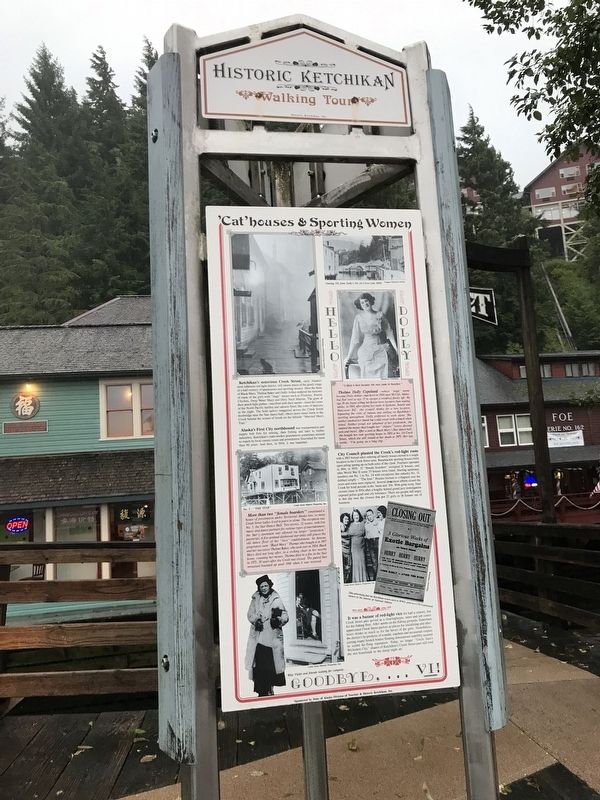
Dolly Arthur… one of the Creek’s longest “working” residents
This house was the home of Dolly Arthur, Ketchikan’s most famous “sporting woman.”
From 1919 through the 1940s, it was also her place of business.
Dolly, whose given name . . . — — Map (db m112038) HM
On Creek Street at Stedman Street, on the right when traveling north on Creek Street.
In spite of its more respectable Stedman Street address, this building — along with its Creek Street neighbors — was one of the earliest houses of prostitution, built soon after the Town Council banned prostitution to this side of the Creek. . . . — — Map (db m182042) HM
On this site over 100 years ago, a 22-foot waterwheel turned, creaked, and groaned to power the Ketchikan Shingle Mill. It was an ingenious creation of pioneer Austin “Ott” Inman.
Inman and his partner, Charles Borch, first used the mill as a . . . — — Map (db m182074) HM
One of Ketchikan's oldest buildings and the Territory of Alaska's only registered brothel.
Infamous owner “Black Mary” Thomas added a dance hall with an inlaid star in the floor, giving the building its name.
Thelma Baker Graham bought the . . . — — Map (db m182087) HM
Imagine your spouse is appointed as the top official in a distant land. You must now travel thousands of miles to Sitka and make this hill your family's new home.
Elisabeth von Wrangell
Ferdinand von Wrangell, the first governor of Russian . . . — — Map (db m181341) HM
On Harbor Drive at Maksoutoff Street, on the left when traveling west on Harbor Drive.
The 'Cottage-by-the Sea' was constructed in 1897 by Norwegian prospector Captain Hans Christian Pande. While Alaska was still a Territory, the W.P. Mills Company donated this house to the Sitka Woman's Club for a clubhouse, which led to the . . . — — Map (db m241980) HM
On Harbor Drive at Maksoutoff Street, on the right when traveling east on Harbor Drive.
Norman E. Staton Sr. and Ethel L. (Milonich) Staton, lifelong Alaskans moved from Ketchikan to Sitka in 1955 opening their first restaurant, the Pioneer Grill on Katlian Street and their second, the Sitka Café on Lincoln Street before opening . . . — — Map (db m181259) HM
Mollie was a resourceful and independent young woman with a wanderlust and love of frontiers. In 1890, she left home at 18 for Butte, Montana where she spent seven years. Landing in Skagway in 1897, Mollie became popular as a waitress and member of . . . — — Map (db m72786) HM
Near Mummy Cave Overlook Road, 1.5 miles east of North Rim Highway (Indian Route 64).
Spanish soldiers may have fired from this very site during the infamous “massacre” of 1805. Their Navajo targets were huddled in the alcove below and to the left. Spanish accounts describe a day-long battle against Indians . . . — — Map (db m170547) HM
On West Airport Road at North Becker Lake Road, on the right when traveling west on West Airport Road.
In 1899, 14 year old Bertha Wahl was murdered here by a shepherd. Just south of here was the original Becker Store. Beyond lie the graves of the Becker family. Due west stood Henry Springer's Mercantile. — — Map (db m36647) HM
On North Garden Avenue near Sherbundy Street, on the right when traveling north.
The Carmichael House was built by William and Margaret Ziegan Carmichael on 131.05 acres. On December 11, 1911, Margaret, a single woman at the time, purchased the property from John and Ellen Reilly for $8,000. As the years passed, the Carmichael . . . — — Map (db m27894) HM
On South 3rd Street south of East Allen Street, on the right when traveling south.
In 1879 there were 11 people in Tombstone of Chinese descent. By 1882 there were 250. The area between 2nd and 3rd and Allen and Toughnut was the area where they lived and had businesses, commonly called "Hoptown". The Chinese ran laundries, . . . — — Map (db m131096) HM
On Bonita Canyon Road, on the right when traveling east.
They came when only the brave dared come: They stayed where only the valiant could stay. Born in Sweden. Americans by choice - not by accident of birth, they loved their adopted country and served her well.
Neil
Served five years in the . . . — — Map (db m28368) HM
On West Stewart Street south of North Austin Boulevard, on the left when traveling west.
Was constructed by P. Howard Pregenzer and crew
In Memory of
P. Howard Pregenzer
1894-1980
Resident of Willcox, Arizona 1927-1980
Construction began in 1934 and completed in 1936
Construction sponsored by the City of Willcox, . . . — — Map (db m28415) HM
On North San Francisco Street north of East Birch Avenue, on the right when traveling north.
Arizona Equal Suffrage Assn hosted speech by national suffragist Anna Howard Shaw here in 1912 to promote woman suffrage in Arizona — — Map (db m193161) HM
On El Tovar Road, 0.1 miles north of Village Loop Drive, on the right when traveling west.
For Mary Colter, [Hopi Housel was an opportunity to re-create the distinctive dwelling of an ancient culture and to acquaint the public with the richness and beauty of Native American art. – Virginia Grattan, Mary Colter: . . . — — Map (db m236334) HM
Puebloan traditions reach far back in time and are the basis for the social organization portrayed here. What responsibilities might you have had in this community, given your age and gender?
[Captions:]
Hopi men plant and . . . — — Map (db m61350) HM
On West Glenn Drive at North 56th Avenue, on the right when traveling east on West Glenn Drive.
This property is listed in the
National Register
of Historic Places
By the United States Department of the Interior
Listed July 7, 1989
In 1901, a small group of pioneer women organized the Self Culture Club of Glendale with the . . . — — Map (db m30478) HM
On N. Greenfield Road at E. McKellips Road, on the right when traveling north on N. Greenfield Road.
Commemorative Air Force
Arizona Military Aviation
Walk of Honor
Proudly Recognizes
Arizonan Women Airforce Service Pilots – WASP
1942 — 1944
“We live in the wind and sand … and our eyes are on the stars!”
The . . . — — Map (db m102898) HM WM
On North MacDonald Street at West Second Street, on the right when traveling south on North MacDonald Street.
On March 9, 1917, fifty-three women, inspired by Margaret Wheeler Ross, past president, 1914-1916, of the General Federation of Women's Clubs of Arizona, chartered the "Woman's Club of Mesa". Since 1901, Federated Women's Clubs, an international . . . — — Map (db m27554) HM
On North 84th Avenue at West Jefferson Street, on the right when traveling north on North 84th Avenue.
In 1919, this building was constructed as a meeting place for the General Federation of Women's Clubs – Peoria Woman's Club.
Originally located at the northwest corner of 83rd Avenue and Washington Street, the Clubhouse was restored and . . . — — Map (db m30401) HM
Before 1875 hundreds of heroic women came to Arizona from the East and South. From this group came Arizona's first schoolteachers and the publisher of the first newspaper.
In 1876 a group of pioneer women and their families came from the north, . . . — — Map (db m27385) HM
On West 1st Street, on the right when traveling east.
Tempe founder Charles Trumbull Hayden built a house of willow poles on this site in 1871 and erected an adobe home, store, and blacksmith shop during the next two years. He married Sallie Davis in Visalia, California, and brought her here in 1876. . . . — — Map (db m27585) HM
On South Farmer Avenue, on the right when traveling south.
Begun in 1885, this adobe house was completed in February 1886 by Hiram Bradford Farmer. Professor Farmer was the first principal and sole instructor of the newly founded Territorial Normal School, now Arizona State University. Unofficially the . . . — — Map (db m27560) HM
Near North Pipe Spring Road, 0.3 miles north of Arizona Route 389, on the left when traveling north.
A long line of juniper poles — like the one you see here — set 70 yards apart ended Pipe Spring’s isolation. From 1871 on, telegraph wire connected the ranch first to Utah and then to the outside world. By 1880 Mormon settlements from . . . — — Map (db m149370) HM
On Main Street (Route 66) 0.1 miles east of Beacon Hill Road.
Olive Ann Fairchild, Indian captive and lecturer, daughter of Royse (Royce) and Mary Ann (Sperry) Oatman, was born in Illinois in September 1837 or 1839. In 1850 the family joined a wagon train bound for the part of the Colorado River now in . . . — — Map (db m188959) HM
On Barracks Row, on the right when traveling west.
During the first decade of the Theodore Roosevelt School, girls were housed in the old fort hospital. Since the old barracks that housed the boys was inadequate, a new boys' dormitory was scheduled for construction in 1931. Before that construction . . . — — Map (db m36878) HM
On 400 Street East at Center Street, on the right when traveling south on 400 Street East.
Construction began in 1930 by Jane Hatch, Lizzie Willis and Emma Kartchner. The building was neglected for several years and in the early 1950's seven couples agreed to save the home, which became the clubhouse for the 20-30 Club. On November 2, . . . — — Map (db m36695) HM
Near Homolovi State Park Entrance Road, 5.4 miles north of Arizona Route 87.
In the distance, you can see several mesas. These are called Tuutukwi or the Hopi Buttes, sacred places in Hopi religion. Today, they are used as eagle gathering areas by certain Hopi clans.
Below you are the remains of the East Plaza. Like the . . . — — Map (db m187322) HM
On South Stone Avenue, on the right when traveling south.
Jewish pioneers, among Arizona's earliest settlers, began arriving in the 1850s and for half a century they worshipped in private homes and rented quarters. In 1904, the Hebrew Ladies Aid Society, now the Sisterhood of Temple Emanu-El, . . . — — Map (db m83237) HM
On South Church Avenue at West Broadway Boulevard, on the right when traveling south on South Church Avenue.
Named in 1869 for the convent located adjacent to San Augustín Cathedral. When the seven Sisters of St. Joseph of Carondelet finally arrived in 1870, they opened the city’s first parochial school for girls next to San Augustín. Three years later . . . — — Map (db m69589) HM
On North Church Avenue, on the right when traveling north. Reported missing.
Named in 1869 for the convent located adjacent to San Augustín Cathedral. When the seven Sisters of St. Joseph of Carondelet finally arrived in 1870, they opened the city’s first parochial school for girls next to San Augustín. Three years later . . . — — Map (db m186122) HM
On South Church Avenue at West McCormick Street, on the right when traveling south on South Church Avenue. Reported missing.
Named in 1869 for the convent located adjacent to San Augustín Cathedral. When the seven Sisters of St. Joseph of Carondelet finally arrived in 1870, they opened the city’s first parochial school for girls next to San Augustín. Three years later . . . — — Map (db m186125) HM
On North Court Avenue south of West Council Street, on the right when traveling south.
The Sanborn Fire Maps for the City of Tucson first recorded this building in 1883 as an adobe dwelling with an attached ramada. Between 1901 and 1930 additions were made to the main building and construction was completed on the outbuilding behind . . . — — Map (db m83244) HM
The infantry barracks (no longer in existence) were 75 feet north of the hospital. The one-story building, like all of the barracks at Fort Lowell, had walls 20 inches thick, a dirt roof, and a wooden porch. The barracks were 20 feet wide and 145 . . . — — Map (db m100689) HM
On North Baily Street, on the right when traveling north.
Built for Pablo and Elena Llescas in the early 1860s, this single-story row house has two exterior walls not parallel with respect to the other walls. This indicates construction prior to the 1866 Ruggles Street Grid. This building is constructed on . . . — — Map (db m26795) HM
On North Willow Street, on the right when traveling north.
Emma Monk came to Arizona Territory to teach school at Fort Thomas in the 1880s. She married William Guild in 1887 and taught school in Florence off and on from 1885 to 1897 and was the first Florence principal. She also taught in Red Rock, Casa . . . — — Map (db m68337) HM
On North Willow Street near 10th Street, on the right when traveling north.
The Florence Woman's Club was organized in 1897. In 1929, architects Lescher & Mahoney designed this Spanish Colonial Revival Style clubhouse. The original light fixtures are suspended from the ceiling, and an ornate Spanish-style fireplace is . . . — — Map (db m26746) HM
On Sacaton Road (Arizona Route 87) at Casa Blanca Road, on the right when traveling east on Sacaton Road.
Honoring Native American
Women Veterans
Dedicated February 22, 2003
American Legion Post 84
Sacaton, AZ
Sculptor: Oscar Urrea
Artist: Jim Covarrubias — — Map (db m32844) WM
On Duquesne Avenue near 4th Avenue, on the right when traveling west.
John H. Cady came to Arizona as a soldier in the 1860's and was stationed at Fort Crittenden on Sonoita Creek. Later Cady became a resident of Patagonia and in December of 1900 began building the Patagonia Hotel. He continued to add to the structure . . . — — Map (db m24300) HM
In 1890 James and Adeline Hall purchased 130 acres here above the junction of the Agua Fria River and Lynx Creek. The Halls named their homestead "Orchard Ranch" and, with the help of their children, Sharlot and Ted, produced apples and beef. . . . — — Map (db m33059) HM
On Main Street (Arizona Route 89A), on the left when traveling east.
This building was originally a brothel known as Jennie's Place. It was built in 1898 by Legendary Madam Belgian Jennie Bauters, who came to Jerome from Belgium in 1896.
This was her third building on this site. The first burned down in 1897. . . . — — Map (db m33152) HM
On Main Street (Arizona Route 89A), on the right when traveling east.
Laura Williams owned the antique museum which housed numerous artifacts from Jerome. Laura was one of the founding members of the Jerome Historical Society and served as the Secretary/Treasurer from 1953-1974. She was an employee of Newmont . . . — — Map (db m33189) HM
Near East Gurley Street east of North Arizona Avenue.
There was a time when progress in Yavapai County was spelled S-P-A-R-K-E-S. Grace M. Sparkes came to Prescott, Arizona Territory, at the age of 14 in 1906. By 1911, she was working for the Yavapai County Chamber of Commerce as Secretary, a job she . . . — — Map (db m33137) HM
During the war more than 300,000 women would join the armed forces, many helping to free men to fight on the battlefronts. They served in both the European and Pacific Theaters of Operation as clerks, radio operators, mechanics, ferry pilots, and, . . . — — Map (db m91956) HM
Near South Main Street north of Southeast 2nd Street, on the left when traveling south.
In 1936. Thaden won the Bendix Trophy Race in the first year women were allowed access to compete against men. She set a new world record of 14 hours, 55 minutes from New York City to Los Angeles, California. In her astonishing victory, she flew . . . — — Map (db m236883) HM
On Spring Street at Mountain Street / Owen Street, on the left when traveling north on Spring Street.
Kentucky House Hotel established on this site 1880, Mrs. E.D. Andrews, proprietor. Building survived Great Fire 1888, disappeared by 1900. Street work 1915 created stone wall. Sharp’s Continental Oil Company gas station constructed 1928. Epley and . . . — — Map (db m79756) HM
One of the most captivating legends in Arkansas folklore
is the romantic tale of the mountain's namesake.
According to local legend, during the 18th century, a French
nobleman named Chavet was granted an expedition to explore.
uncharted . . . — — Map (db m233666) HM
On West Washington Avenue at S. Main Street, on the right when traveling west on West Washington Avenue.
February 1, 1878 - December 22, 1950
Tennessee Native -Arkansas Daughter
A good southern wife in the traditional sense.
First:
Elected woman U. S. Senator
Woman to preside over the Senate
Woman chairman of a Senate committee . . . — — Map (db m227550) HM
On North Currie Street east of Currie Avenue, on the left when traveling east.
Woolfolk is author of The History of Marion and History of Crittenden County, an award-winning newspaper editor, graduated from Memphis State Law School in 1985 at the age of 68, entered into private practice, and served as Marion . . . — — Map (db m116783) HM
The present masonry Lamar Bathhouse, completed in 1923, has a symmetrical, California style of architecture. The large lobby contains nostalgic murals of historic landscapes, and country scenes.
Art Deco stairs, signs, and lights decorated the . . . — — Map (db m61777) HM
On Chaney Drive at Riverbank Rd., on the left when traveling east on Chaney Drive.
This dog park is named in honor of Batesville native
Sara Elizabeth Low. Throughout her youth, she was
known for her kindness and helpfulness to others. Sara
carried these traits through adulthood and was remembered
for them by fellow crew . . . — — Map (db m242386) HM
On North Main Street (U.S. 63/79) near Garnett Road, on the right when traveling south.
Miss Willie Kavanaugh Hocker of Wabbaseka
was the designer of the Arkansas state flag. Miss
Hocker, a member of the Pine Bluff Chapter of
the Daughters of the American Revolution, submitted
her flag design to the Arkansas General
Assembly in . . . — — Map (db m167532) HM
On North First Street (U.S. 63/79) south of Myrtle Street, on the left when traveling south.
Miss Willie Kavanaugh Hocker of Wabbaseka, Arkansas, designer of the Arkansas flag, and one of the most interesting personalities of the state. Miss Hocker taught in the public schools of the state for a number of years, and her knowledge of the . . . — — Map (db m167472) HM
To the Confederate women
Whose pious ministration
To our wounded soldiers,
Soothed the last hours of those
Who died far from the objects
Of their tenderest love;
Whose domestic labors
Contributed much to supply
The wants of . . . — — Map (db m106934) HM WM
On Walnut Street at Perry Street, on the right when traveling north on Walnut Street.
The Civil War changed the lives of Southern women in ways they could not have imagined. They lived with anxiety, fear and loneliness. As the war ground on, many felt an increasing sense of desperation and depression. The lives they had known were . . . — — Map (db m107998) HM
On Columbia Street (Business U.S. 49) at Arkansas Street, on the right when traveling south on Columbia Street.
In 1858 a boarding school and convent was established on this site in the former residence of Col. Henry L. Biscoe by four Sisters of Mercy who came from Ireland with Bishop Andrew Byrne. The school was in the middle of heavy fighting during the . . . — — Map (db m51905) HM
On Columbia Street at Arkansas Street, on the right when traveling south on Columbia Street.
This was the site of St. Catherine Convent and Academy. When it
opened in 1858, it was one of two Roman Catholic schools in
Arkansas. Opportunities for a classical education were rare in
Arkansas and the school founded by the Sisters of Mercy . . . — — Map (db m108055) HM
On South Arch Street at West 18th Street, on the right when traveling south on South Arch Street.
Ed and Hilda Cornish built this Tudor Revival style house in 1919. Theo Saunders was the architect.
Ed Cornish (1871-1928), a prominent banker, was president of the German Trust Company, and later president of the American Bank of Commerce and . . . — — Map (db m211500) HM
Near West Markham Street at Ashley Street, on the right when traveling west.
Erected by the J.M. Keller Chapter, Daughters of the Confederacy Little Rock, Nov. 9, 1910. In Loving Remembrance of the Confederate Women of Arkansas. ”O dearly loved! Though ye have gone to other stars or spheres, we still have for you . . . — — Map (db m157555) WM
On Woodlane Street north of West 6th Street, on the left when traveling north.
”Whose pious ministrations to our wounded soldiers soothed the last hours of those who died for the object of their tenderest love; whose domestic labors contributed much to supply the wants of our defenders in the field; whose jealous faith . . . — — Map (db m128513) WM
On Center Street just north of West 15th Street, on the right when traveling south.
Clubwoman, temperance leader and suffragist. Helped found Arkansas Equal Suffrage Association 1888. Led state efforts until her death 1899. — — Map (db m229491) HM
After the U.S. Army closed Fort Smith in 1871, the guardhouse served the Federal Court for the Western District of Arkansas. It remained in use as a jail, detaining primarily women suspected or convicted of federal crimes until 1888. At that time, . . . — — Map (db m58128) HM
On South West Avenue south of West Block Street, on the right when traveling south.
Bennett. G. Clark and Sarah W. Clark deeded this land to William Rust, John H. Cornish, John R. Hampton, and William H. Hines, trustees of El Dorado Female Institute, in 1847. May 7, 1858 Albert Rust deeded additional land to Robert Goodwin. . . . — — Map (db m121358) HM
On North Lindell Avenue at West Douglas Street, on the right when traveling south on North Lindell Avenue.
In 1932, the Arkansas Council of Home
Demonstration Clubs established the
first Women's 4H House in America at the
University of Arkansas. Nine students lived in
the house during its first year, but it proved
so popular that the council began . . . — — Map (db m224754) HM
On North McIlroy Avenue north of West Dickson Street, on the right when traveling north.
The Chi Omega Greek theater was built in
1930 as a gift from Chi Omega, the national
women's fraternity (sorority) that was
founded at the University of Arkansas in
1895 when four coeds and a faculty adviser
chartered the mother chapter, Psi. . . . — — Map (db m224250) HM
On West Maple Street at Oakland Avenue, on the right when traveling west on West Maple Street.
The Chi Omega was the first Greek organization to build its own chapter house on the University of Arkansas campus. Chi Omega (Psi chapter) purchased this lot in the Oakland Place Addition in 1928. Construction begin that that same year and the new . . . — — Map (db m224732) HM
On West Maple Street at Oakland Avenue, on the right when traveling west on West Maple Street.
Founded April 5, 1895
University of Arkansas
by
Dr. Charles Richardson
Ina May Boles
Jobelle Holcombe
Alice Cary Simonds
Jean Marie Vincenheller
Governing Council
April 5, 1995
Melanie Maxwell Shain, S.H.
Mary Ann Hancock . . . — — Map (db m224731) HM
[Top plaque]
Built A.D. 1930
Chi Omega
Greek Theatre
has been placed on the
National Register
of Historic Places
by the United States
Department
of the Interior
[Bottom plaque]
The Chi Omega fraternity . . . — — Map (db m224254) HM
On West Maple Street at Garland Avenue, on the right when traveling east on West Maple Street.
The nation's 42nd president, William J. Clinton (1993-2001), and First Lady, Hillary Rodham Clinton, were faculty members of the University of Arkansas School of Law in the mid-1970s. Mr. Clinton started in 1973, teaching trade regulation, . . . — — Map (db m224737) HM
On West Maple Street west of North Storer Avenue, on the right when traveling west.
On November 15, 1913, the Delta Iota chapter of
Delta Delta Delta sorority became the fourth
sorority installed at the University of Arkansas.
Founders were Juanita Moore, Vesta Kilgore, Aileen
McCoy, Bess Phillips, Anna Bryant, Alma . . . — — Map (db m224719) HM
Near East Rock Street west of Walker Road, on the right when traveling west.
Imagine living in Fayetteville in 1866. The city with a population just under 1000 was still mourning its dead and rebuilding from the destruction of the War Between the States. Mass graves, lonely graves in pastures and roadsides held the remains . . . — — Map (db m224151) HM
On East Dickson Street at North College Avenue (Business U.S. 71), on the right when traveling west on East Dickson Street.
T.B. Van Horne, first pastor of First
Baptist Church, founded Fayetteville
Female Institute on this site in 1858.
Later rechartered in 1861 as Northwest
Arkansas Baptist Female Institute, it
housed a Federal arsenal which was
destroyed by . . . — — Map (db m224239) HM
On East Buchanan Street (Business U.S. 62) at North Neal Street, on the right when traveling west on East Buchanan Street.
On this site stood the former home of Dr. James W.
Webb (1878 1947) and Mrs. Joy Nelson Webb
(1891-1976). Dr. Webb also owned and operated a
dentist office on this property. Mrs. Webb published
and edited the weekly Prairie Grove . . . — — Map (db m225087) HM
On Central Avenue, 0.1 miles north of Main Street (State Highway 17), on the left when traveling north.
Rosetta Tharpe, considered gospel music's first crossover artist and a reputation "the original soul sister" and "Godmother of rock and roll." Born March 20 1915, in Cotton Plant Arkansas she began performing at age four. A singing and . . . — — Map (db m238212) HM
On Pacific Avenue east of Wood Street, on the right when traveling east.
Erected 1889 for Mr. & Mrs. George H. Mastick
The Alameda Chapter of the American Red Cross
was founded here in 1898.
Mrs. Mastick was elected first president.
Dedicated 1982 by the
Alameda Chapter American Red Cross
Alameda . . . — — Map (db m157287) HM
Jean Sweeney
In 1998, Jean Sweeney walked out in this 27-acre former Alameda Belt
Line railroad yard for the first time. Struck by the silence and what a gem
of nature it was, she said, "This has got to be a park.” She saw this as . . . — — Map (db m157024) HM
On Miller Avenue at Ina Coolbrith Path, on the right when traveling west on Miller Avenue.
Ina Donna Coolbrith, California's first poet laureate and the nation's
first state laureate, was considered "the pearl of all her tribe” by her
19th century colleagues during the Bay Area's first literary heyday.
Born Josephine Donna Smith, . . . — — Map (db m152606) HM
On Alston Way at Martin Luther King Jr. Way, on the right when traveling west on Alston Way.
Bobby Seale
class of 1954, while attending Merrit
College, he joined the Afro-American
Association (AAA) and met Huey P.
Newton. Together in 1966, they founded
the Black Panther Party for Self-Defense.
Jean Yonemura Wing
class of . . . — — Map (db m154869) HM
On California Street south of Addison Street, on the right when traveling north.
From 1877 to 1988
the Sisters of the Presentation
of the Blessed Virgin Mary
operated Berkeley's first convent
and parochial school on this block.
The land was donated by
Berkeley pioneer James McGee.
The grounds included a garden and grotto . . . — — Map (db m137043) HM
This park honors the memory of
Frances Elizabeth Willard
1839 - 1898
Feminist
Founder of the Women's Christian Temperance Union
Fighter for women's rights and free public education
First woman college president
First Dean of . . . — — Map (db m239025) HM
Near Cedar Street east of Spruce Street, on the right when traveling west.
City of Berkeley Landmark
designated in 2004
The Hillside Club was founded in 1898 by Berkeley women intent on preserving the natural beauty of the hills. It soon became an influential cultural force. North Berkeley’s curved streets with old . . . — — Map (db m54186) HM
On Durant Avenue near Ellsworth Street, on the right when traveling west.
The Berkeley City Club, organized in 1927, was one of the area’s earliest attempts by women to social, civic and cultural progress. The building, constructed in 1929, is one of the outstanding works of noted California architect Julia Morgan, . . . — — Map (db m100562) HM
Margaret Tehan Dobbel, the granddaughter of Jeremiah and Ellen Fallon. She was born in Jeremiah Fallon’s home, Dublin, 1874. She married Julius Dobbel and had 13 children. They raised cattle and sheep at Rice, Camel, Dougherty and Donlon Ranches. — — Map (db m201556) HM
John & Katherine Donlon Flanagan from Longford, Ireland came to Dublin in 1868. In 1896 John was blinded, but continued to raise sheep and farm with the help of his wife and 3 girls, Eva, Katherine (Murphy), and Elizabeth (Nevin), who was a teacher . . . — — Map (db m201557) HM
On Mission Boulevard south of Washington Boulevard, on the right when traveling south.
This property (43327 Mission Blvd.) was developed in 1895 by Daniel Baker for a livery business. The enterprise continued under the ownership of Edward Coffany, William Rose, and then Andrew Kell, at least until 1916. By 1924, the building was . . . — — Map (db m220207) HM
Owner of the first Japanese restaurant in Hayward California (Kokeshi)
A caring and giving person, known for her generosity and kindness. She exemplifies the American dream. We will all miss her and never forget her. — — Map (db m207577) HM
7116 entries matched your criteria. Entries 101 through 200 are listed above. ⊲ Previous 100 — Next 100 ⊳