Near State Capitol Drive at Capitol Access Road, on the left when traveling east.
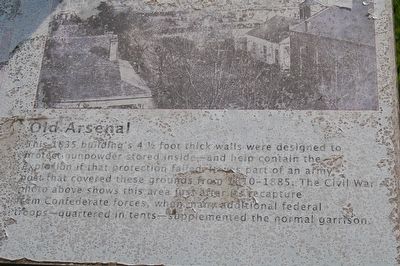
This 1835 building's 4½ foot thick walls were designed to protect gunpowder stored inside—and help contain the explosion if that protection failed. It was part of an army post that covered these grounds from 1810 to 1885. The Civil War . . . — — Map (db m113861) HM
Near North 3rd Street south of State Capitol Drive, on the right when traveling south.
Constructed 1819-1822 to house U.S. troops. Used as a garrison from 1822-1877 except from 1861-1862 when held by Confederates. From 1886-1925 these buildings and grounds were the site of Louisiana State University. — — Map (db m85704) HM
On North Street at Lucillia Lane, on the left when traveling east on North Street. Reported missing.
Built about 1850 by Nathan King Knox and first occupied by the Stewart-Dougherty families, this house was used as a hospital by Union soldiers during the Civil War. It is an excellent example of Classical Revival architecture. — — Map (db m72959) HM
On Park Boulevard at Wisteria Street, in the median on Park Boulevard.
Colonel Henry Watkins Allen, later governor of Confederate Louisiana, was severely wounded near here in the Battle Of Baton Rouge, August 5, 1862. He fell while leading his Louisiana brigade against the Indiana battery in position on Government near . . . — — Map (db m86585) HM
Near Oxford Avenue north of Amherst Avenue, on the right when traveling north.
Confederate soldier, Bynum's Co., 9th La. Batt. Survived the rigors of siege of Port Hudson, returned to his Highland Road Home, only to be killed by a stray bullet while asleep on his bed. Gravesite lost. — — Map (db m143692) HM
On Oxford Avenue north of Amherst Avenue, on the right when traveling north.
Private, 8th Regt, Meriam's Co., War of 1812. Capt., 11th Regt., La. Militia, 1836. Organizer of company of free black volunteers for Confederate States Army. Operator of first regularly established ferry service at Baton Rouge, beginning 1836. — — Map (db m143567) HM
On Tower Drive, 0.1 miles south of Dalrymple Drive, on the right when traveling south.
Louisiana State University and Agricultural and Mechanical College began as the Louisiana State Seminary of Learning and Military Academy, opening its door for the first session on January 2, 1860 at Pineville, LA.
William Tecumseh Sherman was . . . — — Map (db m91003) HM
On Laurel Street at North 17th Street, on the right when traveling west on Laurel Street.
On August 5, 1862, Confederate Divisions of Generals Charles C. Clark and Donald Ruggles under General John C. Breckinridge attacked Federal forces of General Thomas Williams among the tent camps of the 21st Indiana and 7th Vermont Regiments. . . . — — Map (db m43075) HM
On North 19th Street at Laurel Street, on the right when traveling north on North 19th Street.
In 1852 the town of Baton Rouge bought this property for a cemetery. On these grounds, August 5, 1862, the major action of the Battle of Baton Rouge took place. Louisiana novelist Lyle Saxon is among prominent Louisianians buried here. — — Map (db m87227) HM
On North 19th Street north of Convention Street, on the right when traveling north.
In memory of
the officers and men of the Federal
Army and Navy from Massachusetts
who lost their lives in the Department
of the Gulf during the Civil War
1861-1865
Organizations
that served in the Department
4th Infantry
26th . . . — — Map (db m99056) WM
On North 19th Street north of Convention Street, on the right when traveling north.
Federal soldiers killed in the Battle of Baton Rouge, August 5, 1862, were buried on this site which became a National Cemetery in 1867. Among soldiers buried here is General Philemon Thomas, remembered for his attack on the Spanish fort at Baton . . . — — Map (db m87226) HM
On Leon Netterville Drive south of James J Prestage Street, on the right when traveling south.
In memory of P.B.S. Pinchback, the first African American governor in U.S. history. Pinchback, Governor of Louisiana from Dec. 9, 1872 to Jan. 13, 1873, was born free on May 10, 1837. He was a Union Army Officer during the Civil War. In 1868, . . . — — Map (db m85026) HM
On Greenwell Springs Road (State Highway 37) at JL Fairchild Road, on the right when traveling north on Greenwell Springs Road.
Named for the Greenwell family, a resort with a hotel, pavilion and cottages was developed here in the 1850's with stage service to and from Baton Rouge. General John C. Breckinridge's Confederate troops camped here in August 1862. The hotel burned . . . — — Map (db m85681) HM
On Samuels Road (U.S. 61) south of Port Hudson State Park Road.
In May 1863 Union forces
commanded by General
Nathaniel P. Banks laid siege
to the Confederate stronghold
at Port Hudson, just west of
here. The Confederates under
General Franklin Gardner
inflicted heavy casualties
on Banks' army . . . — — Map (db m133735) HM
Near Port Hickey Road (State Highway 3113) 1.9 miles west of Samuels Road (U.S. 61), on the right when traveling west.
Civil War Dead
An estimated 700,000 Union and Confederate soldiers died in the Civil War between April 1861 and April 1865. As the death toll rose, the U.S. Government struggled with the urgent but unplanned need to bury fallen Union . . . — — Map (db m93325) HM
On Old Scenic Highway (State Highway 964) at Plains-Port Hudson Road, on the right when traveling north on Old Scenic Highway.
On May 21, 1863, a two-story building near this site housing Young’s store and the Plains Masonic Lodge was the center of a battle between Colonel William R. Miles’ Legion comprised of Confederate troops from Louisiana and units of General C.C. . . . — — Map (db m93475) HM
On Port Hudson Cemetery Road (State Highway 3113) at Port Hickey Road, on the right when traveling west on Port Hudson Cemetery Road.
Fall of Port Hudson In May 1863, Union Gen. Nathaniel Banks landed 30,000 soldiers at Bayou Sara north of Port Hudson. A force of 7,500 men commanded by Confederate Gen. Franklin Gardner held the Mississippi River stronghold. General Banks' . . . — — Map (db m129210) HM
On Old Scenic Highway (State Highway 964) at Church Street (State Highway 64), on the right when traveling south on Old Scenic Highway.
Seven miles west is site of anchor fort controlling Mississippi. Here 6500 Confederates held 30,000 Union troops May 21 until July 8, 1863. Fall of Port Hudson opened river, hastening fall of Confederacy. — — Map (db m91993) HM
Left side
The fall of New Orleans in April 1862, capped the beginning of an 18-month drive to control Vicksburg and the Mississippi River. The fight for this strategic location was arduous. Vicksburg, sitting high atop . . . — — Map (db m90404) HM
On U.S. 65 at Ingram Street, on the right when traveling north on U.S. 65.
In early 1863 Federal General U.S. Grant dug a canal here connecting the Mississippi River and Lake Providence. This attempt to use bayous and rivers to bypass Vicksburg failed. — — Map (db m90201) HM
Marker middle
Winter Quarters
Winter Quarters, the country home of Haller and Julia Nutt, is the only plantation home along Lake Saint Joseph that survived the Vicksburg campaign. The Nutts were Union sympathizers who . . . — — Map (db m90405) HM
On Lake Street (U.S. 65) 0.2 miles north of Huggins Street, on the right when traveling north.
In early 1863, Union troops commanded by Gen. U.S. Grant dug a canal connecting the Mississippi River and Lake Providence. They camped in an area known as "Soldiers' Rest," which provided a temporary home. — — Map (db m89783) HM
On College Street at Pine Street, on the right when traveling south on College Street.
In the late evening of August 3, 1863, Col. John L. Logan's Confederate cavalry (500 men), approached from the northwest by way of the Jackson-Woodville Road. Their scouts soon subdued the Federal pickets with the aid of local residents. . . . — — Map (db m108639) HM
On College Street (State Highway 952) near Sycamore Street, on the right when traveling south.
The 2nd Vermont Battery's flight took it southward {1} down East Colloge Street, It's best hope was to reach the Clinton Road (present-day LA 10), turn East, cross the Spring Branch and rejoin the main body of retreating Federals. The battery's . . . — — Map (db m231804) HM
On College Street at High Street, on the right when traveling south on College Street.
As the Confederates kept up the pressure on the retreating Federals in the ravine to your distant front {1}, Sergeant Willis W. Davis of West Feliciana
was killed near this intersection {2} while leading an attack at the side of Colonel . . . — — Map (db m108664) HM
On College Street south of High Street, on the right when traveling south.
As the remaining gun of the 2nd Vermont rumbled by this point, hotly pursued by Confederate cavalry {1}, the main body of Federal infantry and cavalry {2} made its way, under Confederate pressure, through the woods and ravine and reached . . . — — Map (db m108671) HM
On East College Street north of Erin Street, on the right when traveling north.
From this point, a domed clock tower can be seen (to your left) above the distant tree line. This building (completed circa 1855) was known in 1863 as the State Insane Asylum. The surviving crew of the 2nd Vermont Battery probably reached Spring . . . — — Map (db m226648) HM
On State Highway 951, 0.1 miles south of Charter Street (State Highway 10), on the left when traveling south.
Lt. Col. McKowen, 1st. La. Cavalry, C.S.A., who on June 3, 1863, with 5 men captured Brig. Gen. Neal Dow near here. Dow was later exchanged for Brig. Gen. W.H.F. Lee, son of Gen. Robert E. Lee. A former mayor of Portland, Me. Dow ran for president . . . — — Map (db m85778) HM
Near College Street (State Highway 952) at Pine Street, on the right when traveling north.
Centenary College minutes dated October 7, 1861 read, "Students have all gone to war. College suspended and God help the right." From 1861 to 1866 the college remained closed. Both Union and Confederate troops used and misused college buildings and . . . — — Map (db m85521) HM
Near College Street near Pine Street, on the right when traveling north.
The East Wing dormitory was the first of the campus structures to be built. Built between 1832 and 1833, the building was designed by Captain Delafield, and constructed by Alexander Smith of Wilkinson County, Mississippi at a cost of $14,000.00 . . . — — Map (db m108617) HM
On Old Scenic Highway (State Highway 964) at Dougherty Lane, on the left when traveling north on Old Scenic Highway.
1 mile SW. Built c. 1848 by Albert G. Carter. A portion of Sarah Morgan Dawson's A Confederate Girl's Diary was written here. Bombardment of Port Hudson and other events at Linwood are described in this important Civil War source. . . . — — Map (db m93427) HM
In 1864, where the main road once entered
town, the 17yr. old Confederate soldier was
killed by pursuing Yankee cavalry as he
carried a secret dispatch. While attempting.
to gallop across broken bridge decking,
his mount failed to clear a . . . — — Map (db m226717) HM
On Carrs Creek Road (State Highway 68) at Charter Street (State Highway 10), on the right when traveling north on Carrs Creek Road.
At noon, June 20, 1863, at the crossroads, a long Union wagon train, escorted by 300 cavalry and 500 infantry, from the 52nd. Mass, Vols., the 2nd. Rhode Island, and Grierson's 7th Ill. cavalry, was ambushed by a Confederate battalion of La. and . . . — — Map (db m108615) HM
"Owing to the ruggedness of the ground and felled timbers, the enemy could not preserve their lines intact and soon became a conglomerate mass. We waited their approach in silence. When within forty yards we were commanded to fire. A blaze of . . . — — Map (db m128569) HM
"The attack was a huge bushwhack. The rebels availed themselves of the thickets, trees, fallen timber ridges, ravines and also of rifle pits and networks of earth and log construction at convenient points and being concealed and protected gave . . . — — Map (db m129209) HM
"Two pieces of siege artillery were removed during Tuesday (May 26
1863) night from the heavy batteries on the river and mounted on
this line---one rifled 24 pounder, under command of Lieutenant
Sanford, Company A, First regiment Alabama . . . — — Map (db m128532) HM
"...no less than four mortars were planted for the purpose of shelling our rifle pits, and the battery at Bennetts stables immediately opposite, but these after firing steadily for several days & nights, without doing us the slightest damage, . . . — — Map (db m128273) HM
"During the fierce assault on May 27 on our whole left wing, Commissary Hill was an essential object of attack. Here we had a four gun battery, and behind it were our commissary stores, arsenal and old ginhouse containing the little grist mills . . . — — Map (db m128494) HM
Near U.S. 61, 1 mile north of Plains/Port Hudson Road, on the left when traveling north.
"Colonel Johnson had galleries dug under his breastworks through which his men could crawl into the outer ditch and sharp shoot from that..." Lieutenant Howard C. Wright Company C 30th Louisiana Infantry Regiment In order to have safe . . . — — Map (db m100640) HM
Near U.S. 61, 1 mile north of Plains/Port hudson Road, on the left when traveling north.
"I had a small flanking pit constructed on the outside or rather under my works, and on the left thereof, and from which I continued a deadly fire until he [the enemy] left the ditch. This pit was subterranean and could not be seen from the . . . — — Map (db m100641) HM
Field artillery cannon, like 6-pounder guns and 20-pounder Parrotts, were towed from location to location by two wheeled carriages called limbers. Teams of six or four horses, grouped in pairs, were harnessed to the limbers, and the left side . . . — — Map (db m128509) HM
Near U.S. 61, 1 mile north of Plains/Port Hudson Road, on the left when traveling north.
"At this junction what was supposed to be a flag of truce was raised, and the rebels, thinking it was a signal for a cessation of hostilities, ceased firing along the line, during which the regiment sought and secured a safer position not quite . . . — — Map (db m100643) HM
"A desperate charge carried a small force of men through this road to a
very advance position which they successfully held, in one of these gullies.
Luckily we got into a fine place and were able to hold our own, though I
was in mortal fear . . . — — Map (db m128868) HM
Near U.S. 61, 1 mile north of Plains-Port Hudson Road, on the left when traveling north.
"…so terrible had been the fighting....that the position was called Fort Desperate."
Colonel Benjamin W. Johnson
15th Arkansas Infantry Regiment
Commander of Fort Desperate
Not a fort but a defensive . . . — — Map (db m97268) HM
Near U.S. 61, 1 mile north of Plains/Port Hudson Road.
"Seeing Colonel Steadman's right wing...heavily pressed and in danger of being flanked, I ordered Lieutenant Edrington to open upon him [advancing Union forces] with shrapnel and shell. He fired with great rapidity, coolness and precision" . . . — — Map (db m100637) HM
"Nearly all the pieces stationed upon the Commissary Hill, to guard the
approaches to the mill between the left wing and the center, were either
dismounted or other wise disabled. Against this point, the enemy had
established two batteries of . . . — — Map (db m128495) HM
"Another (solid shot) struck a tree about thirty feet from the ground, cutting it completely off at a point eight inches in diameter the top as it fell killing one horse and crushing a caisson of the First Maine Battery, a little in front of the . . . — — Map (db m128531) HM
"Lieut. Rhodes...deployed his men at intervals so as to occupy the whole ridge commenced firing on the enemy [black Union troops] both front and rear doing terrible execution and throwing them into confusion and disorder, they still continued to . . . — — Map (db m128272) HM
Near U.S. 61, 1 mile north of Plains/Port Hudson Road, on the left when traveling north.
"At the same time the approaches to Fort Desperate were checked by deadly fire of the Arkansas marksmen there, who, perched up in their sharpshooter tower, could fire down into every part of the enemy's ditch, which had now been brought within . . . — — Map (db m100638) HM
"About the middle of the siege, the enemy attempted to make a sneak through our lines in the night. A picked command was formed, possibly a thousand men. They selected the slaughter pen route. This pen stood on a high bluff, deep ravines from . . . — — Map (db m128492) HM
"Colonel Steedman having been put in command of the left wing, composed of the First Alabama, 15th Arkansas and 10th Arkansas, a detachment of Wingfield's battalion and 39th Mississippi regiment. Colonel Steedman, during the siege, won the . . . — — Map (db m128533) HM
Near State Highway 61, 1 mile north of Pride/Port Hudson Rd., on the left when traveling north.
"...as an additional security against assault, now that the enemy had approached so near, I had a number of 8, 10, and 13-inch shells planted in the scrap wall of ditches as "torpedoes" and connected them by means of wires, with the interior of . . . — — Map (db m97320) HM
Robert Parker Parrott, a former U.S. army officer,
invented a series of rifled, reinforced-breech, iron cannon.
The cannon were manufactured at the West Point Foundry
in Cold Springs, New York, and were made in different
calibers: 10-pounder . . . — — Map (db m128869) HM
Near U.S. 61, 0.4 miles south of State Highway 68, on the right when traveling south.
Marker 1
32-pounder guns were the smallest standard "sea-coast" cannon and among the smallest "ship-borne" cannon in 1861. These cannon were made of iron, were designed with smoothbore barrels, and were intended to throw solid shot at long . . . — — Map (db m96867) HM
Near Old Highway 61 North (U.S. 61) 0.4 miles south of Louisiana Highway 68, on the right when traveling south.
Both the U.S. Army and Navy started using 42-pounder cannons early in the 19th century. They were among the largest cannons in use at that time. Due to their great size and weight, these cannons were used only at established forts and on the . . . — — Map (db m86234) HM
Near U.S. 61, 1 mile north of Plains-Port Hudson Road, on the left when traveling north.
Marker 1
In 1822, Lieutenant Colonel Paixhan, of the French artillery, submitted a plan for using long-chambered cannon at slight elevations to throw large heavy shells at a long range in the same way as solid shot.
Other countries, . . . — — Map (db m96897) HM
Near U.S. 61, 1 mile north of Port Hudson/Plains Road, on the left when traveling north.
"…a cleared space was found, overlooking deep ravines in which trees had been chopped down and left as they fell, and on the opposite side of which the newly thrown up works of the enemy (Fort Desperate) were plainly visible. The two . . . — — Map (db m97263) HM
Near U.S. 61, 1 mile north of Plains-Port Hudson Road, on the left when traveling north.
"...they (the Federals) threw up rifle pits all around my works, distant about two hundred and fifty yards, and all of these, aided by artillery, he kept up a terrible and steady fire upon every part of my position..."
-- Colonel . . . — — Map (db m97259) HM
"About the 10th of June, the enemy planted four mortars in position
near the battery opposite Bennett''s House. These mortars gave us
great annoyance; they were fired day and night, to the very great
disturbance of our troops; yet few were . . . — — Map (db m129393) HM
".. I am still with Rochester battery and think so far I like artillery
service better than the infantry... Captain Harrower shows himself
to be a brave and prudent commander."
--Private George Coleman
Company B
161st New York . . . — — Map (db m129243) HM
"..to our right and left upon tree trunks, were nailed white
crosses which had evidently served for practice, to get the
exact range of the rebel guns, and they had it. For instance, a
section of the First Maine Battery came plunging . . . — — Map (db m129221) HM
Near U.S. 61, 1 mile north of Plains/Port Hudson Road, on the left when traveling north.
"With admirable celebrity the pioneers (trail blazers) opened up the roads and Capt. Duryea brought up the division artillery and within fifteen minutes after driving him (Confederate skirmishers) in, our batteries were answering his guns from . . . — — Map (db m100645) HM
Near U.S. 61, 1 mile north of Plains-Port Hudson Road, on the left when traveling north.
"...on the front of another division commander, I find another serpentine approach, which has been dug very wide, and yet could not admit more than four or five men abreast. It ends near the rebel parapet..."
Lieutenant Colonel Edward . . . — — Map (db m98772) HM
Near U.S. 61, 1 mile north of Plains/Port Hudson Road, on the left when traveling north.
"...he [attacking Union troops] moved...up to my ditch again, and by digging a small place, or bank that intervened between the head of the ravine and the said ditch [the exterior ditch surrounding Fort Desperate]. which was not more than one . . . — — Map (db m100642) HM
On Control House Road near 8th Street (State Highway 158), on the right when traveling west.
At 6:00 PM on April 26, 1864, here, near the junction of Cane and Red Rivers the Confederates set up an artillery battery to intercept Federal gun boats. Two boats were captured. More than 200 people on board the vessels were killed or wounded. . . . — — Map (db m136284) HM
On Jungle Garden Road near Avery Island Road/Main Road, on the right when traveling west.
Petite Anse actually means "Little Cove"'' in Louisiana French.
This particular bayou runs along the west side of Avery
Island before flowing south into Vermilion Bay and the Gulf
of Mexico (through the Avery Canal). In the 19th . . . — — Map (db m118481) HM
On Avery Island Road (State Highway 329) 0.2 miles north of Pepper Field Road, on the left when traveling north.
Salt evaporated from brine springs on Avery Island since 1791. On May 4, 1862, workmen enlarging these springs to produce more salt for the Confederacy hit solid salt at a depth of 16 feet. Mining operations, the first of this type in North America, . . . — — Map (db m195107) HM
On East Old Spanish Trail (State Highway 182) 0.4 miles south of LSU Bridge Road, on the right when traveling north.
This home, originally known as Pine Grove, was bought in 1830 by John W. Jeanerette, the first postmaster between New Iberia and Charenton, and for whom Jeanerette is named. This historic home escaped the destruction of military operations in the . . . — — Map (db m85278) HM
On West Old Spanish Trail (State Highway 182) 1 mile Spanish Lake Road (Parish Road 123), on the right when traveling north.
From 1862-1863 Camp Pratt was official Confederate camp of conscription and instruction for South Louisiana. At one time as many as 3,000 conscripts here. A small compound for Union prisoners of war also located at the camp. — — Map (db m174096) HM
On West Main Street (State Highway 182) at Jefferson Street (Route 3156), on the left when traveling west on West Main Street.
Built in 1858 on land donated by Harvey Hopkins. Consecrated May 16, 1858 by the Rt. Rev. Leonidas Polk, first Episcopal Bishop of Louisiana. This Gothic Revival structure is the oldest non-residential building in New Iberia. During the War Between . . . — — Map (db m86911) HM
On River Road (State Highway 405) 0.7 miles south of Troxclair Drive, on the right when traveling south.
West of this marker lies the grave site of a Union Soldier who was killed in a skirmish with Confederate soldiers at Bayou Goula on January 25, 1865. His name is believed to be Private David Ingraham, Third Rhode Island Calvary, Company H. He was . . . — — Map (db m91986) HM
On Court Street (State Highway 3066) at Church Street (Route 1), on the right when traveling west on Court Street.
Built in 1847 by Dr. Edward Scratchley. Occupied as school by Marianite Sisters from 1859-1862 & 1865-1975. Occupied as military command by Union Army 1862-1865. Renovated by Lt. Governor and Mrs. Robert L. Freeman-1990 — — Map (db m87254) HM
On State Highway 1 east of Willow Street, in the median.
This approximately 10-foot long, 32- pounder gun was cast at the Columbia Foundry Georgetown, D.C., for the United States Navy in 1821. It was originally part of the armament of the USS Columbia, until the ship was decommissioned in 1848. . . . — — Map (db m100635) HM
On State Highway 1 east of Willow Lane, on the right when traveling east.
Two miles N.E. on Grand Terre. Land occupied by Jean Lafitte until 1814, purchased by U.S. from Etienne DeGruy in 1834. Fort constructed 1841 to defend Barataria Pass. Site never saw combat. Abandoned after the War Between the States, guns were . . . — — Map (db m100013) HM
On Mississippi River Trail, on the right when traveling south.
Ferry operated from 1898 to 1942 with two transfer boats. One, the Gouldsboro, named for railroad magnate Jay Gould, was built in 1863 as the Federal Monitor Chickasaw and saw action at the Battle of Mobile Bay. — — Map (db m129478) HM
On Huey P Long Avenue at 1st Street, on the left when traveling south on Huey P Long Avenue.
Approx. 200 feet SW of this site, cast first gun for the Confederate Navy on 4 May 1861. The gun, a Dalhgren cannon, fired an 8~inch diameter explosive shell. Sylvester Bennett was proprietor. — — Map (db m81063) HM
Near Mississippi River Trail near Mardi Gras Boulevard, on the right when traveling north.
Completed in 1849, this three story building treated sailors until abandoned after the 1858 Belle Crevasse. During the War Between the States, gunpowder was manufactured at the site and arson was suspected when the building exploded on December 18, . . . — — Map (db m205421) HM
On River Road (Route 611-1) at Causeway Boulevard, on the right when traveling south on River Road.
In 1862 Confederate and Louisiana authorities laid out Camp Parapet as a part of the defense lines of New Orleans. The works were designed to protect the city against an attack from the north. After the Federals, coming up from the south, captured . . . — — Map (db m92004) HM
On Arlington Street, 0.1 miles east of Causeway Boulevard.
Part of Civil War fortification which extended from the river northward about 1-3/4 miles past Metairie Rd. Construction began in 1861 by the Confederates and continued after the fall of New Orleans by Union forces which occupied the area with many . . . — — Map (db m92005) HM
On Jefferson Highway (U.S. 90) at Causeway Boulevard, on the right when traveling east on Jefferson Highway.
In 1862 Confederate and Louisiana authorities laid out Camp Parapet as a part of the defense lines of New Orleans. The works were designed to protect the city against an attack from the north. After the Federals, coming up from the south, captured . . . — — Map (db m92006) HM
On River Road (State Road 611-1) at Central Avenue, on the right when traveling north on River Road.
Built in 1857 for François Pascalis de Labarre IV. Occupied by Union Troops during the Civil War. After 1892 was a gambling casino, Jesuit retreat house and St. Agnes Church. Magnolia School since 1935. — — Map (db m125236) HM
On River Road (State Highway 541) 0.1 miles north of Wiegand Drive, on the right when traveling north.
Area known as Nine Mile Point; Site of Fortier Plantation and one of area's first schools, churches and later site of WW I commissary. Once the home of Francois Quinet, Sr., statesman & developer of early New Orleans; nearby was site of Fort Banks . . . — — Map (db m86597) HM
On Seven Oaks Boulevard (State Highway 18) at River Road (Route 541), on the right when traveling west on Seven Oaks Boulevard.
Formerly Petit Desert, a 1719 concession. Among first parish settlements, it was a trading post and major entry port of the Louisiana colony. 1794 Michael Zeringue established Seven Oaks Plantation. His son, Camille, built Greek Revival style main . . . — — Map (db m81062) HM
On West Pinhook Road at La Rue France, on the right when traveling north on West Pinhook Road.
Battle of Pinhook Bridge April 17, 1863. Battle of Bayou Vermilion October 9, 1863. We honor the memory of those soldiers who valiantly fought on these banks. — — Map (db m49059) HM
On University Avenue near Azalea Street, on the right when traveling south.
1829-1864. Confederate brigadier general from Lafayette who served in Shiloh, Lafourche, Teche, and Red River campaigns. Killed at Mansfield, leading Confederacy to its most important military victory west of the Mississippi. — — Map (db m49063) HM
On Jefferson Street at Lee Avenue, on the left when traveling south on Jefferson Street.
Jean Jacques Alfred Mouton
Born in Opelousas La. February 18, 1829
Killed at the Battle of Mansfield La. April 8, 1864
when 35 years of age. — — Map (db m125494) HM WM
On East 1st. Street (State Highway 1) 0.1 miles south of Bowie Street, on the right when traveling south.
Originally named Acadie, the name was changed to Acadia in the 1830's. Once owned by Jim Bowie, the hero of the Alamo, whose family owned it from 1827 to 1831. The house was consolidated into one building from two Creole cottages and a shotgun . . . — — Map (db m102046) HM
On State Highway 308, 0.1 miles north of Bartley Lane, on the right when traveling south.
On the east side of Bayou Lafourche was fought the most important battle in Lafourche Parish during the War Between the States. On June 20 and June 21, 1863, units of the 23rd Connecticut Volunteers and 25th New York Battery, commanded by Lieutenant . . . — — Map (db m85427) HM
On Jackson Street south of Seventh Street, on the right when traveling south.
Born in Terrebonne Parish, Felix Grundy Winder was a member of a family originally from Tennessee. His mother, Martha Grundy, was a daughter of Felix Grundy, the distinguished Tennessee friend and political advisor of Andrew Jackson and Attorney . . . — — Map (db m114170) HM
Near Jackson Street south of Seventh Street, on the right when traveling south.
Born in 1834, in Donaldsonville, Francis Nicholls attended West Point but turned to the law. He established his own law practice in Napoleonville in the late 1850s before entering the Army of the Confederacy as a Captain during the Civil War. . . . — — Map (db m114103) HM
On St Mary Street (State Highway 1) west of Ridgefield Road, on the right when traveling east.
Homesite of distinguished Confederate brigadier-general, twice governor of Louisiana 1877-80 and 1888-92; he was appointed Chief Justice of the Louisiana Supreme Court serving from 1892 until 1911. — — Map (db m85466) HM
Near Jackson Street south of Seventh Street, on the right when traveling south.
Mississippi natives George Seth Guion and Caroline Lucretia Winder Guion moved to Thibodaux in 1831. Their Ridgefield Plantation included the land given to St. John,s Episcopal Church and Cemetery and the Guion Academy, two blocks away on Jackson . . . — — Map (db m114082) HM
On State Highway 308, 0.1 miles south of Percy Brown Road (State Highway 648), on the left when traveling south.
A 1785 Spanish Land Grant to Acadian Etienne Boudreaux is part of the largest surviving 19th Century Plantation manufacturing complex in the United States. Over 70 structures, including a sugar house, school, general store and workers' cottages are . . . — — Map (db m81067) HM
Near Jackson Street south of Seventh Street, on the right when traveling south.
Born in Raleigh, North Carolina, in 1806, Polk attended the University of North Carolina before receiving an appointment to West Point, from which he graduated in 1827. He soon resigned his commission, however, was ordained an Episcopal priest, and . . . — — Map (db m113542) HM
Near East First Street (State Highway 1) 0.1 miles south of Jones Lane, on the right when traveling south.
Side A
We care not whence they came
Dear is their lifeless clay
Whether unknown or known to fame
Their cause and country still the same
They died and wore Gray.
Side B
In memory of the thirty-nine members of Co. A. 2nd . . . — — Map (db m94473) HM WM
360 entries matched your criteria. Entries 101 through 200 are listed above. ⊲ Previous 100 — Next 100 ⊳