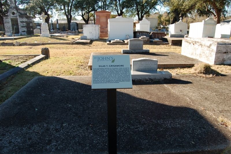
Near Jackson Street south of Seventh Street, on the right when traveling south.
Silas Grisamore arrived by steamboat from his native southern Indiana in the mid 1840s. He taught school in Assumption Parish, sold goods from flatboats on Bayou Lafourche, and eventually became a merchant in Thibodaux. During the Civil War, . . . — — Map (db m114078) HM
Near Jackson Street south of Seventh Street, on the right when traveling south.
William Alexander Shaffer was born in Winnsboro, South Carolina, in 1796. His father migrated to the United States from Prussia. Shaffer settled in Louisiana, on Little Bayou Black, Terrebonne Parish, in 1835. He obtained a United States land . . . — — Map (db m114084) HM
On Main Street (State Highway 42) 0.2 miles west of Walnut Street (Route 22), on the right when traveling west.
In memory of Sallie Martinez Martin, for the dedication of this cannon on December 16, 2006, in honor of her great-grandfather, Johann Dreystadt, and the preservation of the history of Springfield, LA. Johann was born December 23, 1831 in . . . — — Map (db m86019) HM
On Florida Boulevard (U.S. 190) at Aster Street, on the right when traveling east on Florida Boulevard.
Originally named Milton Old Field for Michael Milton who claimed land in 1853. Walker post office established in 1856. Named for Wm. E. Walker, MD, state legislator and organizer of Co. D 16th LA Inf., CSA. Town incorporated in 1909. — — Map (db m88243) HM
Near Old Highway 80 East at Stafford Drive, on the left when traveling south.
On June 7, 1863, black troops fought a vicious battle to defend the Union supply base at Milliken’s Bend, 15 miles northwest of here. Their victory proved black troops could fight well and helped ensure that the siege at Vicksburg would end in Union . . . — — Map (db m84474) HM
Near Old Highway 80 East at Stafford Drive, on the left when traveling south.
During the summer of 1862, the Federals’ first attempt to bypass Vicksburg by digging a canal across DeSoto Peninsula failed. By January, 1863, the Federals had reoccupied the Louisiana shore opposite Vicksburg. Gen. U.S. Grant ordered work on the . . . — — Map (db m84467) HM
Near Old Highway 80 East at Stafford Drive, on the left when traveling south.
This canal was the third attempt by the Union armies to route gunboats around Vicksburg. Excavation was begun in January 1863, by order of General Grant with two regiments and 1,200 Negro laborers. Two dredge boats were used in February but were . . . — — Map (db m84469) HM
Near Old Highway 80 East at Stafford Drive, on the left when traveling south.
The remains of the canal you see here today are the result of the second Union effort to bypass Vicksburg.
In January 1863, laborers and troops under the command of Maj. Gen. Ulysses S. Grant resumed work on the canal begun in June 1862. They . . . — — Map (db m84472) HM
Near Old Highway 80 East at Stafford Drive, on the left when traveling south.
In 1862, powerful Confederate guns along Vicksburg’s high bluffs kept the Mississippi River closed to Federal shipping. Union leaders decided the army should take the city by land to gain control of the river. But General Thomas Williams had a . . . — — Map (db m84468) HM
Near Old Highway 80 East at Stafford Drive, on the left when traveling south.
Known as Connecticut’s Irish Regiment, due to its predominant makeup of soldiers born in Ireland, the Ninth was mustered in at New Haven in September 1861. In December, the 845-man regiment arrived at Ship Island, Mississippi, and was among the . . . — — Map (db m84476) HM WM
Near Old Highway 80 East at Stafford Drive, on the left when traveling south.
U.S.
African Brigade
District Northeast Louisiana Army of the Tennessee
Col. Isaac F. Shepard
Post of Milliken’s Bend Louisiana
Col. Hiram Scofield
8th Louisiana, Col. Hiram Scofield
9th Louisiana, Col Herman Lieb, Maj. . . . — — Map (db m84475) HM
Near Old Highway 80 East at Stafford Drive, on the left when traveling south.
U.S.
Operations Against Vicksburg May 18 - July 24, 1862;
Department of the Gulf.
Maj. Gen. Benjamin Butler;
2d Brigade, Department of the Gulf.
Brig. Gen. Thomas Williams;
----------
9th Connecticut Infantry, Col. Thomas W. Cahill; . . . — — Map (db m84471) HM
Near Old Highway 80 East at Stafford Drive, on the left when traveling south.
Rather than attack Vicksburg directly, the Federals at first tried to engineer their way around the Confederate stronghold.
In June 1862, Union troops started digging a canal across the foot of DeSoto Point. The theory: the river would adopt . . . — — Map (db m84470) HM
On Interstate 20 at milepost 184 when traveling west.
Grant's March Map included
Winter Quarters
Winter Quarters, the country home of Haller and Julia
Nutt, is the only plantation home along Lake Saint Joseph
that survived the Vicksburg campaign. The Nutts were
Union sympathizers . . . — — Map (db m60239) HM
The fall of New Orleans in April
1862, capped the beginning of an 18-month drive
to control Vicksburg and the Mississippi River.
The fight for this strategic location was arduous.
Vicksburg, sitting high atop bluffs, was . . . — — Map (db m60227) HM
On Thomastown Road at Ashley Plantation Road, on the left when traveling north on Thomastown Road. Reported missing.
At daybreak on June 7, 1863, Gen. H. E. McCulloch led his Texas Brigade against the Union force which guarded the Union supply depot at Milliken’s Bend. In the savage fighting which ensued, the Confederates drove the Federals from their camp. While . . . — — Map (db m34798) HM
On Old U.S. Highway 65 (State Highway 603) 1.2 miles south of Lee Street, on the left when traveling south.
During the second week of May 1863, the Federals abandoned their supply line connecting Milliken's Bend with Hard Times. On June 4, the Confederates reoccupied Richmond. From Richmond, Gen. Dick Taylor launched an offensive to destroy the Union . . . — — Map (db m89049) HM
On State Highway 602 at Crescent Plantation Drive, on the right when traveling east on State Highway 602.
During the Civil War, Crescent was the home of Dr. D.M. and Elizabeth DeMoss Dancy. The house was built in 1832.
When Gen. U.S. Grant's Federal forces occupied Madison Parish, an officer and several soldiers came to Crescent with orders to burn . . . — — Map (db m89054) HM
On Thomastown Road at Ashley Plantation Road, on the left when traveling north on Thomastown Road.
The succeeding markers identify the route of march by General U.S. Grant through Louisiana. Erected 1962 by Jimmy H. Davis, Governor of Louisiana.
Louisiana Civil War Centennial Commission. R. J. Breaux • Mrs. Frank J. Pava • Rep. Jesse M. . . . — — Map (db m214569) HM
On Bayou Drive (U.S. 65) at Virginia Street, on the right when traveling south on Bayou Drive.
Scottland Plantation House is a frame, center-hall plantation house, that is one of only three surviving Greek Revival structures in Madison Parish. The house was once at the center of the 1,440 acre Scottland Plantation from which much of Tallulah . . . — — Map (db m89044) HM
On Old U.S. Highway 65 (State Highway 603) 1.2 miles south of Lee Street, on the left when traveling south.
Col. T.W. Bennett's task force, which had been sent to reconnoiter the route from Milliken's Bend to New Carthage, reached this point at 2:00 P.M. on March 31, 1863. If the Federals were to occupy Richmond, they would first have to cross Roundaway . . . — — Map (db m89050) HM
On North Cedar Street (U.S. 65) at Depot Street, on the right when traveling south on North Cedar Street.
Tallulah was founded in 1857. In 1862 it was an important telegraph and railroad station on the Vicksburg, Shreveport, and Texas Railroad. On August 18, 1862, the depot, telegraph office, and several cars were destroyed by a small detachment of . . . — — Map (db m89792) HM
Near State Highway 119, 1 mile north of State Highway 1, on the right when traveling north.
Though far from the fighting for most of
the Civil War, the Red River Campaign in
the spring of 1864 brought the war and
its destruction to Magnolia Plantation.
Retreating Confederates contributed to
the first wave of destruction in . . . — — Map (db m227835) HM
Near State Highway 1221, 1 mile east of State Highway 120, on the right.
Here lies an unknown Confederate,
killed by Union troops, April 2, 1864,
during the Red River Campaign.
This soldier had been cut off from
his unit following a skirmish at
nearby Crump's Hill. He was shot
at this site while attempting . . . — — Map (db m175894) HM
Near Louisiana Route 1221 at Parish Road 585, on the left when traveling north.
Civil War
Cook, Columbus A. • Lacy, William
World War
Carroll, Rufus • Ferguson, William • Free, David Greenwood • Jennings, E. R. Lige • Parker, James Dallas
Korean War
Ferguson, John D. • Ganey, Clarence A. • Gentry, . . . — — Map (db m214329) WM
On Rebel State Park Entrance Road, 0.3 miles south of State Highway 1221.
In memory of William Hodge
Barnhill, his family and descendants. Here on his homeplace
April 3, 1864 he and his sons
buried a Confederate soldier
killed by Union forces. This
gravesite was maintained by
the Barnhill family for 98 yrs — — Map (db m175224) HM
Near Louisiana 494 (State Highway 494) near State Highway 119.
As the Civil War descended into the Red River valley in 1863, the presence of U.S. soldiers located in nearby Alexandria
began to disrupt plantation life and watchmen were posted each night. On June 20, 1863, Oakland Overseer, J. T. McNeely
wrote . . . — — Map (db m242183) HM
On State Highway 494, 0.3 miles north of Cedar Bend Road, on the right when traveling north.
(side 1)
This c. 1836 center hall Creole cottage is of poteaux sur sole, (hand-hewn pegged cypress sills on brick piers) and bousillage construction on the 1780s land grant to Claude Pierre Thomas Metoyer. The lower 68 acres given to a . . . — — Map (db m70645) HM
Many African cultures had an
iron-working tradition which was
passed down from father to son.
Plantations required blacksmiths
to make and repair tools and
hardware. While the Blacksmith
Shop no longer stands, the work
of these craftsmen . . . — — Map (db m242152) HM
On Front Street (State Highway 6) at Trudeau Street, on the right when traveling north on Front Street.
In April 1864, life along tranquil Cane River was brutally disrupted when the Civil War reached area residents. In an operation known as the Red River Campaign, Union naval and land forces advanced up the Red River valley from occupied portions of . . . — — Map (db m106514) HM
On Camp Street, 0 miles Andrew Higgins Drive, on the right when traveling south.
This 8 in. Columbaid, cast of Alabama iron by the Confederates at Selma, Ala. was mounted in Spanish Fort, Mobile Bay.
The Fifth Company Slocomb's Battery Battallion Washington Artillery of New Orleans, during the siege of that fort by the U.S. . . . — — Map (db m38901) HM
On Canal Street at Decatur/Magazine Street, on the right when traveling west on Canal Street.
United States Customhouse Has been designated a National Historic Landmark This site possesses national significance in commemorating the history of the United States of America — — Map (db m28113) HM
On Saint Charles Avenue near Sixth Street, on the right.
This congregation was founded in 1805, the first Episcopal church established in the former Spanish colony after the Louisiana Purchase. In its first service was held in the Cabildo on November 17, 1805. An octagonal Gothic church designed by . . . — — Map (db m104918) HM
On St Charles Avenue east of Eighth Street, on the right when traveling west.
Built in 1869 for "Yankee in Grey," Capt. Watson Van Benthuysen, II, CSA. Relative by marriage of Jefferson Davis & Q'master of Presidential convoy that fled Richmond in April, 1865, Van B. became merchant and industrialist with interests in St. . . . — — Map (db m96018) HM
Erected by The Croatian Benevolent Association of Louisiana in memory of those members who gave their lives in service of their country, the United States of America, during the wars.
Army Cpl. George Petrovich killed in action at Gettysburg, . . . — — Map (db m51293) HM
On Chartres Street at St. Peters, on the left when traveling north on Chartres Street.
The Napoleon 12-pounder cannon was originally developed by France in 1853 under Emperor Napoleon III. American manufacturers later used the design for cannon production during the Civil War.
On September 14, 1874, the Metropolitan Police used . . . — — Map (db m221518) HM
On Chartres Street at St. Peters, on the left when traveling north on Chartres Street.
This Spanish long cannon was originally mounted at Fort St. John near Lake Pontchartrain, known to locals as Spanish Fort. It was used in the American defenses at the Battle of New Orleans in 1815 and then once again during the Civil War against . . . — — Map (db m221520) HM
On Decatur Street east of St. Peter Street, on the right when traveling east.
[Panel 1]:
On and near this site since 1718 has centered the military activities of both regular and citizen soldiers of France, Spain, the Confederacy and the United States. On either side were the redoubts forming the “Great . . . — — Map (db m24684) HM
Built in 1859 for
Colonel Robert H. Short
of Kentucky, commission merchant,
Henry Howard, architect,
Robert Huyghe, builder.
In 1832 this property, which was part of the Lavaudais Plantation was subdivided into city squares.
September 1, . . . — — Map (db m51497) HM
Born at Fairview, KY. June 3, 1808
U.S. Army 1828-1835
Served in Black Hawk War
Congressman U.S. 1845-1846
Colonel Mississippi Volunteers in War with Mexico
Rendered Gallant Service in the taking of Monterey and Buena Vista where he was . . . — — Map (db m51521) HM
Louisiana provided the largest number of black Union troops during the Civil War. Many lie buried here. The most notable, Capt. Andre Cailloux, fell while courageously leading a charge of the Louisiana Native Guards in 1863 at Port Hudson, La. . . . — — Map (db m161738) HM
Near Avenue L near Avenue D, on the right when traveling west.
John Bell Hood was born June 29, 1831, in Owingsville, Kentucky, and
was reared in Mt. Sterling, Kentucky. After graduating from West
Point in 1853, he served in the elite U.S. 2nd Cavalry Regiment on the
Texas frontier. In 1861, he joined the . . . — — Map (db m157658) HM
On North Jefferson Davis Parkway at Canal Street, on the left when traveling north on North Jefferson Davis Parkway.
Col. Charles Didier Dreaux
Born in New Orleans May 11, 1832
First Conf. officer from Louisiana
Killed in the War Between
the States on the field of
honor near Newport News, VA.
On July 5, 1861
His last words were
"Boys steady" . . . — — Map (db m86011) HM WM
On South Jefferson Davis Parkway at Tulane Avenue (U.S. 61), in the median on South Jefferson Davis Parkway.
Grand Commander, Supreme Council 33° Ancient and Accepted Scottish Rite of Freemasonry, southern jurisdiction. U.S.A., 1859 - 1891. Erected April 27, 1957 by the Grand Consistory of LA., 32° Ancient and Accepted Scottish Rite of Freemasonry to . . . — — Map (db m102982) HM
On Saint Charles Avenue at General Taylor Street, on the right when traveling east on Saint Charles Avenue.
Erected 1875
for
the St. Charles Avenue
Methodist Church South
Charles L. Hillger, Architect
James Cox, Builder
Robert Walker Rayne
purchased the site
and made a major contribution
to the cost of its erection
in memory of his son . . . — — Map (db m88787) HM
On Belle Chasse Highway (State Highway 23) at Avenue B, on the right when traveling south on Belle Chasse Highway.
Site once part of Bellechasse plantation. Established by Col. Jean de Goutin Bellechasse, commander of colonial troops at the Louisiana Purchase transfer in 1803 and prominent early state official. Purchased in 1844 by Judah P. Benjamin, noted . . . — — Map (db m84137) HM
On Main Street (Louisiana Route 996) 0.3 miles north of F. Edward Hebert Boulevard, on the right when traveling north.
Designed by De Verges and garrisoned in 1754, but abandoned in 1792, because of strategic value it was rebuilt by Latour in 1808 and garrisoned to defend New Orleans; Destroyed by Adm. Farragut during the Civil War in advance up the river. — — Map (db m205785) HM
On Louisiana Route 23 at Herbert Harvey Road, in the median on State Route 23.
Built 1822-32 to protect the lower river. Named for Andrew Jackson. 1862 - Fort withstood 10-day siege by Farragut and surrendered after city fell. In 1898 and 1917-18 used as training base. 1961 - Fort was declared a national monument. — — Map (db m35091) HM
On State Highway 418, 0.3 miles south of Jacko Lane, on the right when traveling south.
Home of river boat captain, state senator, and Simmesport founder, General Bennett Barton Simmes. Built in the Greek Revival and Italianate styles. Occupied in the War Between the States by Union General Nathaniel P. Banks. His headquarters during . . . — — Map (db m97842) HM
On Bayou Fordouche Road (State Highway 10) 0.6 miles north of State Highway 77, on the right when traveling north.
On Sept. 29, 1863 Confederate forces of Texas and Louisiana commanded by Brig. Gen. Tom Green defeated Union forces of the 13th Army Corps capturing 500 men and 2 cannons. The battle is also known as the Battle of Sterling's Plantation. This marker . . . — — Map (db m94325) HM
On 3rd Street north of Johnston Street, on the left when traveling south.
Side A Unnamed during the colonial period, Alexandria's beginnings as the major city in central Louisiana are traced to ca. 1797, when the "seat of justice" for Rapides Post was transferred from the north to the south bank of Red River. By . . . — — Map (db m38290) HM
On Washington Street at 5th Street, on the right when traveling north on Washington Street.
This site, located in the town's center square, was set aside for public use on the original town plat commissioned by Alexander Fulton in 1805. The building was constructed solely for advancement of culture and learning in 1907 by Caldwell . . . — — Map (db m38292) HM
On Grady Britt Drive east of West Campus Avenue, on the left when traveling east.
"Headquarters 1st Calvary Division, Army of West La., May 8, 1864 General Order No. - The Brig. Gen. commanding takes occasion to call the
attention of their comrades to the gallantry displayed by the
officers and men of Terrell's and . . . — — Map (db m118259) HM
On Main Street at Murray Street, on the left when traveling west on Main Street.
Four 19th century Rapides Parish residents served Louisiana as governor. Joseph Marshall Walker (1784-1856), a Bayou Rapides cotton planter, was governor 1850-53 -- the first to be installed in the newly-designated Baton Rouge capital. During his . . . — — Map (db m38325) HM
On 3rd Street south of Murray Street, on the left when traveling south.
Side No. 1 On this site in 1906, the City Library known as the Manning Memorial Library was opened, named in honor of a 19th century resident who served his State and his Nation. Hundreds of his personal volumes were donated to this library, . . . — — Map (db m38291) HM
On Shreveport Highway (U.S. 71) south of Rigolette Road (State Road 1203), on the left when traveling south.
1860 The Louisiana State Seminary of Learning and Military Academy, the predecessor of the Louisiana State University, opened at this site in January 1860 with Colonel William Techmseh Sherman as its first superintendent, five faculty . . . — — Map (db m111560) HM
Near East Shamrock Street (Business U.S. 165) near Main Street, on the left when traveling south.
Civil War AlexandriaAlexandria, Louisiana, served briefly
of the Confederate Department of the Trans-Mississippi,
as the headquarters a vast area encompassing states and territories west of the
Mississippi River.In spring 1863, the . . . — — Map (db m136134) HM
On Riverfront Street west of Main Street, on the left when traveling west.
"If damming would get the fleet off, it would have been afloat long before." Rear Admiral David D. Porter Lieutenant Colonel Joseph Bailey While Union officers surveyed the situation and discussed the possible loss of the boats trapped . . . — — Map (db m38532) HM
On April 15, 1865 General Robert E. Lee surrendered to Brigadier General Ulysses Grant. At Fort Buhlow, soldiers quickly fled home, feeling that the end of the war was near. With the threat of a Union advance northward, Brigadier General Joseph . . . — — Map (db m148002) HM
In March 1865, bad news reached the forts from other
parts of the Confederacy. The worse news arrived on
April 15; General Robert E Lee was forced to surrender
to Brigadier General Ulysses S. Grant. As these reports
reached the forts, . . . — — Map (db m176747) HM
Near Shreveport Highway (U.S. 71) south of Rigolette Road (State Road 1203), on the right when traveling north.
William Tecumseh Sherman, a graduate of West Point, was appointed the fist superintendent and a professor of engineering of the Louisiana Seminary of Learning & Military Academy. In June of that year, General G. Mason Graham wrote to Major D.C. . . . — — Map (db m111061) HM
On Monroe Highway (U.S. 71/165) near Rainbow Drive, on the left when traveling east. Reported missing.
Fort Buhlow and Fort Randolph were earthwork/moat fortifications constructed beginning October 1864 by Confederate forces anticipating a repetition of Union Gen. Nathaniel Banks’ Summer 1864 Red River
Expedition. Construction, completed March 1865, . . . — — Map (db m7848) HM
Near Riverfront Street, 1 mile north of Main Street.
There are no detailed descriptions or illustrations of how Fort Buhlow was built. However, through military reports and other historical records it is known that Fort Buhlow was a circular earthwork fort with an outer ditch around it. It was . . . — — Map (db m147330) HM
Near Riverfront Street, 1 mile north of Main Street, on the right when traveling north.
There are no detailed descriptions or illustrations of
Fort Randoiph being built. However, it is known from
historic al reports that earthwork forts were roughly
circular in shape and had outer ditches surrounding
them. Fort Randolph was . . . — — Map (db m176465) HM
On Main Street (Business U.S. 165) south of Ball Street, on the right when traveling south.
The cemetery was purchased in 1858 by St. James Episcopal Church, Alexandria. It is the second oldest cemetery in Rapides Parish and has always served as a community burial ground. The earliest marker is 1824.
Mount Olivet Chapel was established . . . — — Map (db m110590) HM
Near Main Street (Business U.S. 165) south of Ball Street, on the right when traveling south.
Oldest Structure in Pineville. It was completed in 1857. At one time during the Civil War, it served as barracks for the Federals. Mount Olivet now serves as a chapel of the Episcopal Diocese of Louisiana. — — Map (db m110432) HM
On Main Street at Riverfront Street on Main Street.
City of AlexandriaThe first merchant to locate in what is now Alexandria was Edmund Murphy, Irish trader, who opened a trading post where Bayou Rapides meets the Red River. He later received a land grant where the city of Pineveille now stands. . . . — — Map (db m116055) HM
On Shreveport Highway (U.S. 71) south of Rigolette Road (State Road 1203), on the right when traveling north.
Provided for by Constitution of 1845 with funds from fed. land grants. Opened, 1860; closed during Civil War; reopened, 1865. Burned 1869; moved to Institute for Deaf, Dumb, and Blind, Baton Rouge. Became Louisiana State University, 1870. — — Map (db m110942) HM
On Shreveport Highway (U.S. 71) at Rigolette Road (State Road 1203), on the right when traveling north on Shreveport Highway.
Louisiana acquired the land on this site as the location of the Seminary of Learning of the State of Louisiana in 1853. George Mason Graham from nearby Bayou Rapides chaired the Board of Trustees appointed to construct a building and determine the . . . — — Map (db m136033) HM
On Riverfront Street west of Main Street, on the left when traveling west.
The Lexington is freed By May 8, the water level had risen five feet four inches, allowing the lighter draft gunboats, the Fort Hindman, Neosho, and Osage, to cross the upper rapids and wait behind the dams. Fearing that . . . — — Map (db m38534) HM
On Riverfront Street west of Main Street, on the left when traveling west.
"I trust some future historian will treat this matter as it deserves to be treated, because it is a subject in which the whole country should feel an interest..." Rear Admiral David D. Porter May 16, 1864 Assembling the Troops In March . . . — — Map (db m38368) HM
Welcome to Fort Buhlow. This was a Confederate Civil War fort built in 1864.
It was an earthwork fort constructed with a ditch around it. You may notice that the fort was built on a hill overlooking the Red River. This was a strategic location . . . — — Map (db m147024) HM
Near Riverfront Street, 1 mile north of Main Street.
Fort Buhlow is named after Lieutenant Alphonse Buhlow. Buhlow entered the Confederate Army on August 18, 1861 as a private in the 11th Louisiana Infantry Regiment. He was transferred to the Trans-Mississippi Department as a lieutenant where he . . . — — Map (db m148005) HM
Near Riferfront Street, 1 mile north of Main Street.
General Kirby Smith organized five artillery batteries called the Siege Train Battalion to be posted at Fort Buhlow and Fort Randolph. In mid-December 1864, Major Richard M. Venable arrived at the forts. He had trained as an artillery and engineer . . . — — Map (db m147588) HM
Near Riverfront Street, 1 mile north of Main Street (Business U.S. 165).
Major General Kirby Smith chose five artillery batterie to be stationed at the forts. They were known as the Siege Train Battalion and consisted of the 26th, 27th and 31st regiments, and the 8th Battalion of Heavy Artillery and the 2nd Field . . . — — Map (db m174738) HM
Near Riverfront Street, 1 mile north of Main Street.
Why was Fort Buhlow built? Fort Buhlow was built in response to rumors that the Union Army was going to attack the Red River in the spring of 1865. General Edmund Kirby Smith, commander of the Confederate Trans-Mississippi Department, saw that . . . — — Map (db m147326) HM
Near Riverfront Street, 1 mile north of Main Street, on the right when traveling north.
Louisiana had suffered repeated invasions by the
Union Army in 1863 and 1864. There were fears
that a spring 1865 attack was going to be made.
General Edmund Kirby Smith, commander of the
Trans-Mississippi Department, saw a need for . . . — — Map (db m176369) HM
On the Lock and Dam No. 4 access road, on the left when traveling north.
April 12, 1864, C.S.A. Brig. Gen. Tom
Green was killed near here leading his
Texas cavalry in a duel against the Union
monitor Osage, gunboat Lexington,
and the transport Black Hawk at the
Battle of Blair's Landing. Of his passing Lt. Gen. . . . — — Map (db m7575) HM
On Chalmette National Park Scenic Road (Tour Loop Rd), 0.6 miles east of Battlefield Road, on the right when traveling north.
Chalmette National Cemetery was established in 1864 as a burial place for Union soldiers who died in the gulf area during the Civil War. It also served as the site for reburials of soldiers from battlefield cemeteries in the region. This plot of . . . — — Map (db m97175) HM
The United States Congress established this site as a National Cemetery in 1864 for the re-interment of Union soldiers who died in Civil War hospitals and were buried in various nearby locations.
Over 15,000 veterans of American wars and their . . . — — Map (db m161730) HM
On U.S. 90 at Magnolia Ridge Road, on the right when traveling east on U.S. 90.
Union train with sixty men ambushed by Confederate force of Louisiana militia and volunteers on September 4, 1862. Train escaped to New Orleans. Fourteen Union soldiers killed and twenty-two wounded in the skirmish. — — Map (db m58214) HM
Le district des Allemands, settled by Germans about 1720, the scene of numerous skirmishes between Confederate guerillas and Union forces, 1862-63. Most famous skirmish resulted in capture of an entire detachment of Union soldiers on September 4, . . . — — Map (db m58213) HM
On River Road (State Highway 18) at Plantation Road, on the right when traveling west on River Road.
Home of General Richard Taylor, son of Zachary Taylor, Louisiana statesman and member of the 1861 Secession Convention. Commanded Louisiana District, 1862-64; defeated Banks at Battle of Mansfield, 1864. Federals plundered home in 1862. — — Map (db m58215) HM
On State Highway 38 at State Highway 441, on the left when traveling east on State Highway 38.
In the Civil War was traveled by two Union regiments of Illinois Cavalry May 1, 1863 enroute to Baton Rouge. Col. B.H. Grierson commanded the diversionary raid previous to Gen. Grant's land movement against Vicksburg, Mississippi. — — Map (db m94313) HM
On River Road (State Highway 44) at Judge Poche Road, on the right when traveling north on River Road.
Felix Pierre Poché, Civil War diarist, Democratic party leader, prominent jurist and one of founders of American Bar Association, built this Victorian Renaissance Revival style plantation with unusual front dormer c. 1870. — — Map (db m86218) HM
On State Highway 44, 0.1 miles east of Manresa Street, on the right when traveling east.
Since 1931 The Society of Jesus (Jesuits) have operated a retreat house here for the spiritual development of the laity. The grounds and several of the buildings were the site and home of Jefferson College founded for the education of the youth of . . . — — Map (db m81092) HM
On River Road (State Highway 18) at Post Office Street, on the left when traveling south on River Road.
House claimed by the river was
home of André Bienvenu Roman
(1831-35 and 1839-43)
Governor of Louisiana
(1845 and 1852)
Member of Constitutional Convention (1861) Member of Secession Convention
Member of Peace Commission to . . . — — Map (db m88219) HM
On State Highway 18 at Freetown Street, on the left when traveling south on State Highway 18.
Following the Civil War, thirty-one individuals bought lots from C. Oliver, who acquired portions of land that was formerly a part of the Pedesclaux-Landry Plantation in St. James, LA. Together, the group carved out and cultivated the land and . . . — — Map (db m85008) HM
On State Highway 18, 0.1 miles east of Toth Street, on the right when traveling east.
Enlisted in Confederate Army, 1861; died heroically at Battle of Mansfield, 1864. Served in Yellow Jacket Bat. Com. of 18th Vol. Inf. Reg. and Mouton Brig. His ancestors were Jean Marie, Jean Baptiste, and Jean Seraphim Armant, St. James planters . . . — — Map (db m81081) HM
On State Highway 20 at Guidry Street, on the left when traveling south on State Highway 20.
Route used by Civil War troops. It led from Mississippi River over swamp ridges, Indian trails, through Chackbay (Chegby), Thibodaux and Bayou Lafourche areas, Schriever, Gibson, Morgan City, to Attakapas country. Local militia units took active . . . — — Map (db m121230) HM
Near State Highway 18 at East 3rd Street, on the right when traveling east.
As Madame Beauregard lay dying in New Orleans, she yearned to see her husband once more, but his duties in the Confederate Army made his return impossible. She knew her husband could not be spared as a soldier of the South, and she resigned herself . . . — — Map (db m85143) HM
On River Road (State Highway 18) at East 4th Street, on the right when traveling east on River Road.
From which civil parish was named. First church on second German Coast when Louisiana was a colony of Spain. Served west and east banks of river until 1864. Old cemetery contains wife of Gen. P.G.T. Beauregard and John Slidell family tomb. — — Map (db m85324) HM
Near West Airline Highway (U.S. 61) 0.1 miles east of Percy Hebert Road, on the right when traveling south.
Found in Lake Pontchartrain in St. John the Baptist Parish, one-half mile from Ruddock in 1977. Used as a one-gun battery to guard the railroad along the western side of the lake. It never came under attack. — — Map (db m85762) HM
On State Highway 182, 0.2 miles south of Judson Walsh Drive (Parish Route 1-250), on the left when traveling south.
Here, on October 21, 1863, during the Great Texas Overland Expedition, Union troops under Maj. Gen. Nathaniel Banks, forced Confederates, under Maj. Gen. Richard Taylor, to evacuate Opelousas and move his defensive line 7 miles north. 12 days later, . . . — — Map (db m85920) HM
Near East Landry (U.S. 190) east of South Campus Street, on the left when traveling west.
French for "the old village," Le Vieux Village is a park created by a collection of restored historic structures from Opelousas and surrounding areas of St. Landry Parish. The village depicts the unique and diverse historical and cultural heritage . . . — — Map (db m107525) HM
On South Court Street north of East Landry Street (U.S. 190), on the right when traveling north.
Operating under several different names, a hotel once occupied this spot; an inn and tavern is recorded being here in the late 1700s. Most notably was the Eagle Hotel where the legislature convened during the Civil War when Opelousas served as the . . . — — Map (db m145949) HM