On Buckeye Road east of Ft. Amanda Road, on the right when traveling east.
The many boulders you see represent the conflicts and
wars in which the United States of America has been
involved since
1776. Those conflicts and wars
are identified on
the gray plates at
the bottom of
each flag column. — — Map (db m196377) WM
On Buckeye Road east of Ft. Amanda Road, on the right when traveling east.
The concept of the Freedom flag Monument began in
2001 as a way to thank U.S. Veterans for their service.
Initiated and guided by the UAW from a small cardboard
model, plans were developed and ground was broken in
2004. The monument was . . . — — Map (db m196379) WM
On Buckeye Road east of Ft. Amanda Road, on the right when traveling east.
The Freedom Flag Monument stands in honor of all U.S. Veterans - past, present, and future. In addition to the five major branches of service, veterans of these services are also recognized:
Air National Guard •
U.S. Air Force Reserve • . . . — — Map (db m196380) WM
On Buckeye Road east of Ft. Amanda Road, on the right when traveling east.
Through the study of the development of the United
States flag, we better understand our American
heritage, learn an appreciation for the sacrifices of all
U.S. veterans and realize the need to continue strong
leadership, strong citizenship . . . — — Map (db m196381) HM
[Front]
Dedicated to the memory of all
veterans of the Armed Forces of
the United States of America, who
unselfishly served their country
in time of peace or war. It is
because of this effort that we
enjoy the freedom that is
ours . . . — — Map (db m29732) HM
On High Street at Main Street, in the median on High Street.
Erected 1903 by the
Citizens of Jackson Tp. and
Dedicated to the
Memory of her soldiers of
1861. - 1865.
[Grand Army of the Republic emblem]
Ah! never shall the land forget.
How flowed the life blood of her brave
Gushed warm . . . — — Map (db m29718) HM
On Main Street, on the right when traveling south.
The Korean War
June 25, 1950 - July 27, 1953
—————————
To honor those
who fought and died
to secure the freedom
of the People of South Korea
Forgotten Nevermore
by . . . — — Map (db m22929) WM
The Lima Chapter of the American Women's Voluntary Services Organization established a community-based, free canteen during World War II for troops traveling on the Pennsylvania Railroad and adjacent Baltimore & Ohio-Nickel Plate Railroads. Meeting . . . — — Map (db m22951) HM
On Buckeye Road, 0.5 miles west of South Dixie Highway, on the left when traveling west.
The Veterans Freedom Flag Monument dedicated May 22, 2010 to Veterans who made the sacrifice for freedom around the world, those who currently serve in the military and those who will serve in the future. Built entirely through the donations of . . . — — Map (db m63076) WM
On Ohio Route 603, on the right when traveling south.
Tensions between Native Americans and Euro-American settlers remained high on the Ohio frontier during the War of 1812. Grievances mounted rapidly following the removal of the Greentown Delawares to Piqua in the late summer of 1812. On September . . . — — Map (db m28800) HM
On Ohio Route 89, 0 miles south of County Road 800.
Front:
To honor our veterans who have served
POLK
Back:
To those who served and returned ...
To those who served and were lost ...
Your contribution and sacrifice for our freedom is not forgotten.
We are eternally . . . — — Map (db m38799) HM
On Court Street at Washington Street, on the right when traveling south on Court Street.
To honor and commemorate
the Revolutionary Soldiers
buried in Athens County, Ohio
Daniel Anderson •
Thomas Arnold •
Isaac Barker •
Ebenezer Barrows •
Hopson Beebe •
Alvan Bingham •
Silas Bingham, Sr. •
William Bodwell •
John Bowman . . . — — Map (db m15544) HM
Memorial Auditorium stands as a testament to the dedication of Ohio University alumni, who raised funds for its construction. Completed in 1928, Memorial Auditorium was erected to honor those who have died serving our country; this includes past . . . — — Map (db m53845) HM
On Richland Avenue at Plains Road (Ohio Route 682), on the left when traveling south on Richland Avenue.
In honor of the War Correspondents who landed in Normandy, France, on D Day, June 6, 1944, with Allied Invading Forces; and others who joined them to report the Crusade Across Europe to bring freedom to that continent and the eventual end of a . . . — — Map (db m53863) HM
Near West Bailey Road, 0.1 miles west of Converse Street (Ohio Route 13), on the left when traveling west.
During the War of the Rebellion three young men from Chauncey traveled to Parkersburg and Clarksburg, VA., to enlist in what was then the 1st Virginia Cavalry (USA). These "Loyalist Regiments” became West Virginia regiments in June 1863 just . . . — — Map (db m242161) HM
On Ohio Route 198, 0.2 miles south of Deep Cut Road (Local Highway 230), on the right when traveling north.
In Memory Of
The 75 Unknown American Soldiers
of the War of 1812
buried in this cemetery.
Death came to these Patriots ether while on duty
at For Amanda or while in the Fort Hospital to
which wounded were returned from the forward
area. . . . — — Map (db m167040) WM
On West 4th Street west of North Frankfurt Street, on the right when traveling west.
Represents the strong Christian faith of the community. In the eighth century Charlemagne and Benedictine missionaries brought this faith to the Saxon tribes in the Munster and Osnabruck area of Germany.
Oak Leaf and Acorn - The acorn is . . . — — Map (db m238608) HM
On Arch Street at Main Street (Ohio Route 147), on the right when traveling north on Arch Street.
Lest We Forget Those Who
Gave Their All For Our Country
Our Honored W.W. I K.I.A.
Wm. S. Bowen • Mansel E. Kaiser • George R. Higgins
Our Honored W.W. II K.I.A.
Edmund Bradfield • Wayne A. Thomas
Wm. O. Cordner • Lewis Wade
Paul . . . — — Map (db m26864) WM
On 34th Street at Guernsey Street, on the right when traveling west on 34th Street.
Dedicated in grateful tribute
to the honor and sacrifice
of those Citizens of
the Bellaire Area
who gave their lives in
service to their country
Korea
June 1950 - July 1953
Thomas G. Ault • James A. Beveridge • Donald L. Bonar . . . — — Map (db m82482) WM
On Guernsey Street north of 34th Street, on the right when traveling north.
In Memoriam
Armand Fana
who made the
supreme sacrifice
Bill Respole
Prisoner of Japan's
Bataan Death March
[Honor Roll of Veterans] — — Map (db m82513) WM
On Guernsey Street at 34th Street, on the right when traveling north on Guernsey Street.
To our brave men who
sacrificed their lives
to preserve our nation
They Served That Liberty
Shall Not Perish
Andrews Bernard W. ∙ Angus Daniel ∙ Apicella Anthony ∙ Balch Lloyd R. ∙ Bass Clarence R. Jr. . . . — — Map (db m83222) WM
On Church Street at Greenbank Avenue, on the left when traveling north on Church Street.
Burial Site of American Patriots
Molly Scott - Defender in Revolutionary War
Ruhamark Hukill - Jessie Walker
Veterans of War of 1812
David Morton - Veteran of War with Mexico
Martin V. Baile - Joseph B. Frasier - Calvin . . . — — Map (db m226396) HM WM
This memorial plaque was placed by the Zane's Trace Chapter of the Daughters of the American Revolution in grateful memory of those buried in the soil of Belmont County who loved country more than life and served in the American Revolution - 1775 - . . . — — Map (db m214487) HM
On Water Street south of 3rd Street, on the right when traveling south.
Date of Birth
April 27, 1822
Education
1827-1836 Local subscription school in Georgetown, Ohio
1836-1837 Boarding school in Maysville, Kentucky
1838-1839 Boarding school in Ripley, Ohio
1839-1843 U.S. Military Academy at West . . . — — Map (db m166309) HM
On South Main Street just south of East Grant Avenue, on the right when traveling north.
In recognition of
the patriotism of
the people of
Brown County
who oversubscribed their
war savings quota in 1918
this tablet is
gratefully erected by the
Ohio War Savings Committee — — Map (db m214453) HM WM
On Seward Road at Dixie Hwy (Ohio Route 4), on the left when traveling south on Seward Road.
Sergeant • Northern Continental Army
Captain James Osgood’s Company of Rangers
enlisted July 15, 1775
born February 22, 1745, in Rumsford, NH
died July 22, 1823 in Butler Co., OH
marker placed by John Reily Chapter, NSDAR
and . . . — — Map (db m116555) HM WM
On High Street (Ohio Route 129/177) at the east bank of the Great Miami River, on the left when traveling west on High Street.
On this spot in the year of our
Lord 1791 General Arthur St. Clair
founded Fort Hamilton. Here, in 1793
General Anthony Wayne organized his
expedition against the Indians which
gave to this Republic five great states.
Here our . . . — — Map (db m30657) HM
On High Street (Ohio Route 129/177) west of Monument Street, on the right when traveling east.
Pierre-Joseph Celron, sieur de Bienville, with 200 to 250 French soldiers and some Indians, was sent in 1749 to renew and strengthen France's claim to the Ohio country and drive out the British. During navigation of the Allegheny, Ohio and Great . . . — — Map (db m73591) HM
On High Street (Route 129) west of North Monument Avenue, on the right when traveling west.
A gift to the city of Hamilton in recognition of America's Bicentennial. Purchased thru the contributions of its citizens. This is one of the two replica bells cast for use in the state of Ohio by the Whitechapel Bell Foundry, maker of the original . . . — — Map (db m199737) HM
On High Street (Ohio Route 129/177) west of Monument Street, on the left when traveling east.
Fort Hamilton was completed Sept. 30, 1791, and occupied by the U. S. Army commanded by Gen. Arthur St. Clair. The supply base was the first in a chain of outposts north of Cincinnati (Fort Washington) in the Northwest Territory. The log . . . — — Map (db m73600) HM
On Monument Avenue at High Street (Ohio Route 129/177), on the right when traveling south on Monument Avenue.
Side A: Soldiers, Sailors, and Pioneers Monument
The Soldiers, Sailors, and Pioneers Monument was planned and promoted by Butler County Civil War veterans and financed by a county levy in 1899. The monument, built of Indiana Limestone, is . . . — — Map (db m30705) HM
On High Street (Ohio Route 129/177) at Monument Street, on the right when traveling west on High Street.
May all who pause and are refreshed here reflect on those who went forth from their homes to defend American freedom
————————
This fountain, erected 1949, was conceived and sponsored by the . . . — — Map (db m73622) WM
Honoring all Veterans
in times of peace and war
[Includes an Honor Roll of]
Area Veterans Who Died in the
Service of Their Country
Dedicated July 4, 2004 — — Map (db m29991) HM
Dedicated by the grateful citizens
of Middletown to the members
of the armed services who gave
their lives to preserve the
American ideals of liberty
justice and democracy
World War II Memorial
This plot contains a cross for . . . — — Map (db m29979) HM
On West Pike Street (Ohio Route 55) at Wilson Street, on the right when traveling east on West Pike Street.
Born here October 9, 1832. Attended Antioch College. Member of Mt. Olivet Masonic Lodge. Enlisted in the 2nd Ohio Volunteer Infantry Regiment and volunteered for the famous Andrews Raid. The raiders seized "The General" locomotive at Big Shanty, . . . — — Map (db m76518) HM
On Jefferson Street at Plum Street, on the right when traveling north on Jefferson Street.
In memory of those who died for us in World War II:
Niece, Robert •
Richeson, Herman •
Rush, Ralph M. •
Cretors, Robert K. •
Leasure, Karl •
Mott, Garner •
Peacock, Eldon D.
To the memory of those who served in World War II this . . . — — Map (db m13806) HM
On College Way, on the right when traveling south.
Bailey and Barclay Halls. Urbana University was established by the Swedenborgian Church in 1850. Bailey Hall (1853), named after Francis Bailey (1735-1815), was designed by W. Russell West, architect of the Statehouse of Ohio. Bailey was an . . . — — Map (db m13808) HM
On Scioto Street (U.S. 36) at Ames Avenue, on the right when traveling east on Scioto Street.
Side A
Robert L. Eichelberger was born in Urbana on March 9, 1886, the
youngest of the five children of George Maley Eichelberger, an Urbana
lawyer, and Emma (Ring) Eichelberger. After graduating from Urbana
High School in 1903, he . . . — — Map (db m90431) HM WM
On Urbana Woodstock Road (County Route 2) 0.4 miles west of Main Street (Ohio Route 559), on the right when traveling west.
President Abraham Lincoln's assassination on April 14, 1865, created a national tragedy, and the nation mourned as his body was transported by rail from Washington, D.C. back to Springfield, Illinois, where he would be buried. On its way the Funeral . . . — — Map (db m84945) HM
On Troy Road (Ohio Route 41) 0.2 miles west of Dialton Road, on the right when traveling west.
In memory of those who served God and Country.
[Post 4358 Veterans Panel on Memorial]:
Post 4358
Gerald Armstrong •
George Armstrong •
Harry Baker •
James Baker •
Robert Donnelly •
Glen Fuller •
Robert Fuller • . . . — — Map (db m13905) HM
In memory of the men
buried in Clark County
who fought in the
American Revolution
1775 - 1783
Lt. John Bancroft • Jacob Ellsworth
William McIntire • Frederick Brown
Samuel Lippincott Sr. • James Kelly
Corneilus Toland • Isaac . . . — — Map (db m28796) HM
On Main Street at Fountain Avenue, on the left when traveling west on Main Street.
In June of 1780 British and Indian forces seized Ruddle's and Martin's Stations in Kentucky. On August 8, 1780 George Rogers Clark led a force of nearly 1000 Kentucky militia under authority of Virginia to engage the British led Shawnee at the . . . — — Map (db m13887) HM
On High Street at Limestone Street, on the left when traveling east on High Street.
Dedicated to the Springfield community in memory of
John M. Temple, 43rd Infantry US Army
He was a man of honor and integrity. This is the legacy he left behind for others to follow and build upon to continue their journey, pursue their dreams . . . — — Map (db m13906) HM
On Limestone Street (Ohio Route 41), on the right when traveling north.
Dedicated to all men and women wounded in all our wars. My stone is red for the blood they shed. The medal I bear is my country’s way to show they care. If I could be seen by all mankind maybe peace will come in my lifetime.
Erected by . . . — — Map (db m13355) HM
On West Columbia Street (U.S. 40) 0.1 miles east of North Wittenberg Avenue, on the right when traveling east.
The pioneers James and Elizabeth Demint settled this land on the banks of Buck Creek in 1799, four years after the Treaty of Greenville opened this portion of the Northwest Territory to western settlement. James Demint's original plat contained . . . — — Map (db m217130) HM
On Ohio River Scenic Byway (U.S. 52) at Ohio Route 232, on the left when traveling east on Ohio River Scenic Byway.
General in the United States Army and twice elected President of the United States was born on April 27, 1822 in a house on this spot — — Map (db m166839) HM
On Howard Street (Ohio Route 729) near Elm Street, on the left when traveling north.
This memorial is dedicated
to the men and women of
the Armed Forces of the
United States of America.
We will never forget the
sacrifices they made at
home and abroad in times
of war and peace to
protect all of our freedom. . . . — — Map (db m27977) HM
Died in C-123 accident at Ft. Sill, OK
[16] Oct 1980
302 TAW RAFB Col, OH.
Capt. George Freeland, Jr.
Maj. Thomas Brady
Lt. Col. Donald Griffith
T.Sgt. Michael Snodgrass
Sr. Amn. Robert Hass — — Map (db m143964) HM
On South Street (U.S. 68) at Sugartree Street, on the right when traveling north on South Street.
Dedicated to the men & women of Clinton County who served in the
War of 1812,
Mexican, Civil,
Spanish, WW I,
WW II, Korean,
Vietnam and
Persian Gulf War
(Desert Storm)
Afghanistan / Iraq — — Map (db m18727) WM
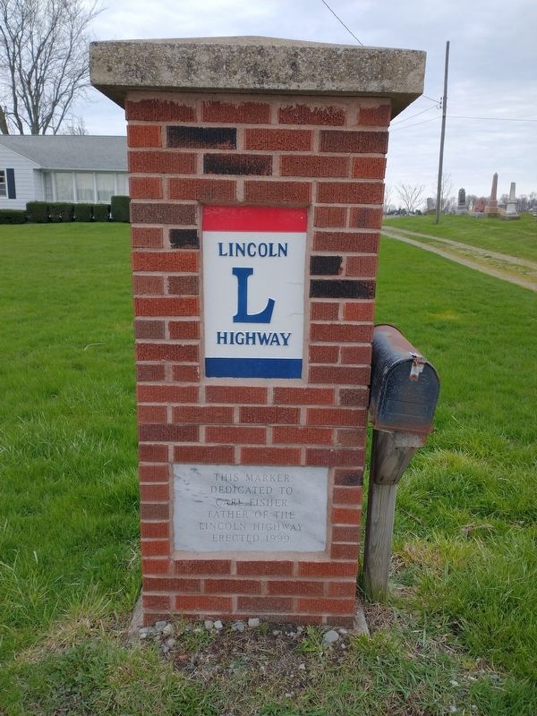
On Lincoln Highway (U.S. 30) at North Market Street (State Route 45), on the left when traveling east on Lincoln Highway.
This cannon and its twin at the cemetery were donated to New Lisbon by President Wm. McKinley (1897-1901). Made of carbon steel, it will never rust or need painted; it is capable of firing a 100 lb. projectile 7-8 miles. McKinley’s mother, Nancy . . . — — Map (db m164135) HM WM
Near Main Street just west of North 4th Street, on the right when traveling west.
Given to the citizens of Coshocton County by the Coshocton Rotary Club in recognition of the National Bi-Centennial on May 24, 1975 — — Map (db m208667) HM
On Main Street (U.S. 36) at Plum Street, on the right when traveling west on Main Street.
Served in the Continental Army under the command of General Washington. Appointed as Accountant of the War Department by Washington and served under Presidents Adams, Jefferson and Madison. For his services in the Continental Army, received a land . . . — — Map (db m227846) HM
On Railroad Street (Ohio Route 93) at Kirk Street, on the right when traveling east on Railroad Street.
In the early morning hours of September 11, 1950, Pennsylvania National Guard Troop Train #4, disabled 3/4 mile east of this monument, was struck in the rear by the passenger train, Spirit of St. Louis, resulting in the deaths of 33 soldiers. . . . — — Map (db m15271) HM
On Harding Way East (Ohio Route 61), on the right when traveling east.
Dedicated in this bicentennial year
to the men and women who
served their country with honor
in all conflicts for freedom
Re-dedicated as “Flag Plaza” this 11th day of November 2006
by the Galion Veterans Memorial Commission . . . — — Map (db m20374) HM
Near Saint Clair Avenue Northeast at East Mall Drive, on the right when traveling east.
Statesman Patriot Beloved citizen of the United States of America Four score and seven years ago our fathers brought forth on this continent, a new nation, conceived in Liberty, and dedicated to the proposition that all men are created equal. Now we . . . — — Map (db m182169) HM WM
Near East 9th Street at Larry Doby Way, on the left when traveling north.
Greatest pitcher in Indians history. Tribe all-time leader in Wins (266), Strikeouts (2581), Starts, Complete Games, and Innings. “Rapid Robert” led A.L. in Wins six times and Strikeouts seven times. Set club single-season records for Strikeouts . . . — — Map (db m182401) HM
Near Lakeside Avenue East east of East 6th Avenue, on the left when traveling east.
Polish American patriot aided the colonists in their fight for liberty dying gloriously in the Battle of Savannah. Brandywine • Germantown • Valley Forge Egg Harbor • Charleston • Savannah — — Map (db m182200) HM WM
On West Saint Clair Avenue just west of West 6th Street, on the left when traveling west.
"The Statue of Liberty Enlightening the World" was a gift of friendship from the people of France to the United States and is recognized as a universal symbol of freedom and democracy. The Statue of Liberty was designed by Frédéric Auguste . . . — — Map (db m177124) HM
On Lakeside Avenue East at East 12th Street, on the left when traveling east on Lakeside Avenue East.
In honor of the many Hungarian Freedom Fighters who fought against Soviet Oppression The crack in the Berlin Wall began with a hole in a flag in Budapest! ”October 23, 1956, is a day that will live forever in the annals of free men and . . . — — Map (db m192545) HM WM
Near East 9th Street at Larry Doby Way, on the left when traveling north.
[north side]Cleveland Indians, American League 1936-1941 • U.S. Navy • 1945-1956 Games 570 • Innings 3,828 • Won 266 • Lost 162 • Pct. .621 Strikeouts 2,581 • ERA 3.25 [west side]Born November 3, 1918 • Van Meter, Iowa Signed by . . . — — Map (db m182400) HM
On West Mall Drive south of Lakeside Avenue East, on the left when traveling south.
…..In his copy of Bodin's "Republic" Thomas Jefferson had initialed two pages. On one page was Bodin's definition and characterization of a tyrant, which was quite similar in concept to the phrases used in the Declaration of Independence. On the . . . — — Map (db m182153) HM
Near East 9th Street north of Sumner Avenue, on the right when traveling north.
One Nation Under God with Liberty and Justice for All This site is dedicated to the veterans who lived, served and died for our Country. Within Erie Cemetery are the graves of soldiers from the Revolutionary War and the many conflicts that . . . — — Map (db m192384) WM
On West Lakeside Avenue at Ontario Street, on the right when traveling west on West Lakeside Avenue.
In recognition of the Patriotism of the People of Cuyahoga County who so generously purchased War Savings Stamps in 1918 this tablet is gratefully erected by the Ohio War Savings Committee — — Map (db m192537) HM WM
On Brecksville Road (Ohio Route 21) south of Sunset Avenue, on the right when traveling south.
Army ☆ Navy ☆ Air Force ☆ Marine Corps
Coast Guard ☆ Merchant Marines ☆ All Reserve Forces
This plaza is dedicated to the
sons and daughters of the City of
Independence who have fought to
preserve . . . — — Map (db m137936) WM
On Lorain Road (Ohio Route 10) at West Park Drive, on the right when traveling west on Lorain Road.
Dedicated to the courageous
men and women who have
served our great nation
World War I • World War II
World War II Honor Roll
In loving memory of our boys
who made the supreme sacrifice
Curtis Black • Frank Dewey
Almo W. . . . — — Map (db m44854) HM
On Royalton Road (Ohio Route 82), on the left when traveling east.
Side A:
John Shepherd is believed to be the longest lived veteran of the American Revolution. He died at the age of 117 years, 9 months, and 18 days. He entered military service the first time during the French and Indian War (1754-1763). The . . . — — Map (db m43387) HM
On Olentangy River Road (Ohio Route 315) at Home Road, on the left when traveling north on Olentangy River Road.
Liberty Presbyterian Church
Founded in 1810
The first religious society organized in Liberty Township was formed in 1810 by Elders Thomas Cellar, Josiah McKinnie, and Leonard Monroe. Cellar and McKinnie came to Delaware in 1802. In 1820, The . . . — — Map (db m179476) HM
On Sandusky Street, on the right when traveling south.
In 1850, this eighty acre tract known as the Kilbourne farm was purchased for use as a cemetery. The “Old Burial Grounds,” located where Ohio Wesleyan's Selby Stadium now stands, had deteriorated and most of those remains were removed to . . . — — Map (db m12851) HM
On Riverside Drive (Ohio Route 257) north of Heathrow Drive.
This site marks the northern boundary of "The Kosciusko Lands." When General Kosciusko visited the United States in 1797, Congress appropriated over $15,000 to him and a land grant of 500 acres. This land was part of his reward and pay for services . . . — — Map (db m36754) HM