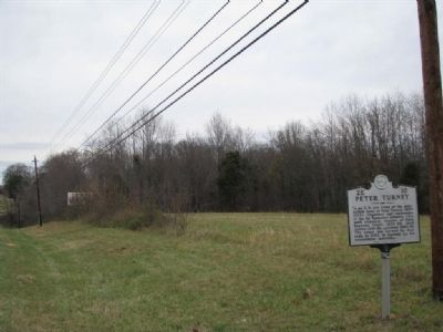
On Cowan Highway (U.S. 41), on the right when traveling west.
1/8 mi. N.W. are ruins of the antebellum home of Peter Turney (1827-1903). Organizer and commander of the 1st Tennessee Infantry CSA until wounded; member of State Supreme Court, 1878-86; chief justice, 1886-93; governor; 1893-97. The house was . . . — — Map (db m25428) HM
On North Trenton Street (Tennessee Route 5) 0.1 miles north of Knox Street, on the left when traveling north.
This pioneer finally settled on a farm about 4 1/2 mi. east. Following his last defeat for reelection to Congress, he went to Texas, where he died in the Alamo massacre. This cabin, restored partly from timbers of his original dwelling by . . . — — Map (db m81555) HM
On Eaton Street (Tennessee Route 104, 77) at South College Street (Tennessee Route 367), on the left when traveling east on Eaton Street.
Pioneer — Statesman — Hero
Born August 17, 1786 • Died March 6, 1836
Served three terms in the Congress of the
United States while a resident of this county.
Emigrated to Texas in 1835, and was killed
at the Alamo fighting . . . — — Map (db m55211) HM
On Elkton Highway (U.S. 31) near Rose Road, on the right when traveling south. Reported missing.
A native of North Carolina, Aaron Brown studied law in Nashville and moved to Pulaski to practice. He served four terms in the State Legislature, three terms in Congress, and one term as Governor, 1845-47. In 1850, he wrote the Tennessee Platform of . . . — — Map (db m34150) HM
Near South Rhodes Street north of East Cemetery Street, on the right when traveling north.
Tennessee State Senator 1821 - 1825
Tennessee State Representative 1831 - 1833
U.S. Congressman 1839 - 1845
Governor of Tennessee 1845 - 1847
Postmaster General of the United States 1857 - 1859
Born in Brunswick County, Virginia August . . . — — Map (db m151140) HM
Edward Eslick, son of Merritt and Martha Abernaty Eslick, was born near Pulaski on April 10, 1872, attended public schools in Pulaski and Bethel College in Russellville, Kentucky. He studied law under William H. McCallum, was admitted to the bar in . . . — — Map (db m75182) HM
Near South Rhodes Street north of East Cemetery Street, on the right when traveling north.
John Calvin Brown was born on Giles County, Tennessee on January 6, 1827. He was one of nine children born to Duncan and Margaret Brown and the brother of Neill S. Brown, Governor of Tennessee (1847-1849). A graduate of Jackson College in Columbia, . . . — — Map (db m75175) HM
Near South Rhodes Street north of East Cemetery Street, on the right when traveling north.
City Recorder of Pulaski
Member, Tennessee State Legislature
Governor of Tennessee 1847 - 1849
United States Minister to Russia 1850 - 1853
Speaker of the Tennessee House of Representatives
A native Giles countian, Neill S. Brown was born . . . — — Map (db m151141) HM
This District was placed on the National Register of Historic Places in 1983 by United States Department of Interior. The Square was laid out in 1811 by the original County Commissioners. Buildings date from 1867 and reflect the Victorian Style of . . . — — Map (db m29806) HM
The Trail of Tears Interpretive Center Popularly known as the Rock Church, this beautiful chapel of Gothic architectural design was constructed by native limestone and was dedicated as the Immaculate Conception Catholic Church on August 10, 1941. A . . . — — Map (db m29810) HM
Near South Rhodes Street north of East Cemetery Street, on the right when traveling north.
Thomas Jones was born in Peron County, North Carolina on December 12, 1816 and moved to Giles County with his family in 1817. Jones received his early education at Wurtemburg Academy and studied at the University of Alabama and University of . . . — — Map (db m75174) HM
On Rutledge Pike (U.S. 11W) at Marshall Avenue, on the left when traveling north on Rutledge Pike.
A native and State Representative of Grainger County, DeWitt Senter voted against secession in 1861. Imprisoned and driven from home by Confederates, he returned in 1865. He served in the State Senate until 1869 when he succeeded to the . . . — — Map (db m80335) HM
On Rutledge Pike (U.S. 11W) at Court Street, on the left when traveling north on Rutledge Pike.
Here the former indentured boy, tailor's apprentice and later 17th President of the United States first set up his own tailoring business in a small brick building which was also the sheriff's office. On the death of his former employer in . . . — — Map (db m80439) HM
Andrew Johnson was born in 1808 to poor, uneducated parents in a small building that served as a kitchen to Casso's Inn in Raleigh, North Carolina. When Andrew was three, his father died after saving two of his wealthy employers from drowning in an . . . — — Map (db m86608) HM
Senator Edmund G. Ross of Kansas, on the eve of the senatorial vote in the impeachment of President Andrew Johnson, exhibited his great love for the democratic process when in reply to extreme pressure he stated, "I do not recognize your right to . . . — — Map (db m234671) HM
Andrew Johnson Seventeenth President of the United States. Born Dec. 29, 1808, died July 31, 1875. His faith in the people never wavered. Eliza Johnson, born Oct. 4, 1810, died Jan. 15, 1876. In memory of our father and mother. — — Map (db m93079) HM
Welcome to the Andrew Johnson National Historic Site. This site commemorates the life and work of the seventeenth president of the United States, Andrew Johnson. Born in poverty, Johnson rose from Greeneville tailor to the nation’s highest office. . . . — — Map (db m93078) HM
On Andrew Johnson Highway (U.S. 321), on the right when traveling east.
Three miles west is the central unit of the Andrew Johnson National Historic Site which includes the 17th president’s small tailor shop, the home in which he lived from 1838 to 1851, a museum, and administrative offices. Other units are the . . . — — Map (db m58152) HM
Eleven mayors of Greeneville resided in the 100 block of McKee Street while serving in office. At interval periods between the years of 1873 and 1972, the following individuals served: Robert M. McKee, N.T. Howard, Tom T. Adams, H.E. Holland, John . . . — — Map (db m23034) HM
On West College Street (U.S. 41) at West Main Street (U.S. 41A), on the right when traveling south on West College Street.
Grundy County
Established 1844; named in honor of
Felix Grundy
of Virginia. Chief Justice of the Kentucky Supreme Court; Rep. in Congress from Tenn. 1811-1814; U.S. Senator 1829-38. Attorney Gen. in President Van Buren's Cabinet. At the time . . . — — Map (db m150469) HM
On Hillsboro Highway (U.S. 41), on the right when traveling south.
Established 1844: named in honor of Felix Grundy of Virginia. Chief Justice of the Kentucky Supreme Court; Rep. in Congress from Tenn. 1811-1814. US Senator 1829-38. Attorney Gen. in President Van Buren's Cabinet. At the time of his death in 1840, . . . — — Map (db m26596) HM
On E Andrew Johnson Highway (U.S. 11), on the right when traveling west.
Here the Kentucky Road, from Cumberland Gap to the Carolinas, crossed the Stage Road, from Abingdon, Va., to the west. In 1790, Jesse Cheek had a store about 50 yds. N.E. On this spot the Deaderick family operated a store with various partners in . . . — — Map (db m22676) HM
On E Andrew Johnson Highway (U.S. 11), on the right when traveling east.
0.4 mi. Built 1785 by Col. James Roddye, from North Carolina. He was subsequently delegate to the North Carolina Constitutional Convention, magistrate and register of Jefferson County under territorial government and member of Tennessee's first . . . — — Map (db m81632) HM
On Georgia Avenue just north of East 7th Street, on the left when traveling north.
Hamilton County
created October 25, 1819, named for
Alexander Hamilton
born January 11, 1757; died July 12 1804. Aide de Camp to
Gen. Washington at twenty: member of Continental Congress at
twenty-five; captain in Revolutionary War; a leader in . . . — — Map (db m150512) HM
On Church Street at Mulberry Street, on the right when traveling east on Church Street.
Created out of rivalry of political factions during the reconstruction period following the Civil War, James County consisted of parts of Hamilton and Bradley counties. Plagued by political strife and supported mainly by farmers unable to provide an . . . — — Map (db m73921) HM
On West 37th Street at St. Elmo Avenue, on the right when traveling east on West 37th Street.
Here the first two post roads established in Hamilton County by the United States government, in 1820, crossed. This spot was also the site of Aaron Hunt's blacksmith shop described in Augusta Evans' book St. Elmo. — — Map (db m28768) HM
On Dayton Pike north of Mountain Road (County Road 1126), on the right when traveling north.
Hasten Poe, a veteran of the War of 1812, moved from Virginia and built a log structure on this site in 1818. The area became known as Poe’s Cross Roads, later Daisy and in 1969 Soddy Daisy. The structure was used as a tavern and inn. On October 25, . . . — — Map (db m74853) HM
Colonel Hardin was born in Virginia but moved to North Carolina in 1772. During the Revolutionary War, he fought at King's Mountain and elsewhere in the South. He was Speaker of the House of the State of Franklin in 1785 and a member of the . . . — — Map (db m28702) HM
On West Main Street (Tennessee Route 54) east of South Grand Avenue, on the right when traveling east.
Born in Brownsville; Vanderbilt School of Law 1890; practiced law in Brownsville, then St. Louis, MO; Circuit Attorney for St. Louis 1900; his anti-corruption successes led to election as Governor of Missouri 1905-1909; Solicitor General of U.S. . . . — — Map (db m194162) HM
On Dancyville Methodist Church Road, 0.2 miles south of Dancyville Road (Tennessee Route 179), on the left when traveling south.
Born Oct. 6, 1793, in Sumner Co. Tenn. Married 1819 to Martha McGee, seven children. Private, War of 1812, enlisted Jan 28, 1814 in Capt. Allen Wilkinson's Company, discharged April 2, 1814. Established Bank of Fayette Co., president until death. . . . — — Map (db m53099) HM
On Tennessee Route 76 at Dancyville Methodist Church Road, on the right when traveling south on State Route 76.
Here on June 23, 1841, James K. Polk, Governor of Tennessee, running for re-election debated James C. Jones, both masters of the stump speech. James “Lean Jimmy” Jones, a Whig, who was a natural mimic and actor, defeated Polk and served . . . — — Map (db m53118) HM
On Monroe Street just south of Church Street (U.S. 412), on the right when traveling south.
Businesses which have operated at this site
24 Monroe Street
Elmer Stewart, Atty. •
Sue's Beauty Salon •
First National Bank •
Austin & Hinson Pool Room •
Jones & White Grocery •
Davenport General Store •
Pearson's Cash Grocery . . . — — Map (db m180497) HM
On Monroe St at South Main Street, on the right when traveling south on Monroe St.
Businesses which have operated at this site
26 Monroe Avenue
Frizzell's Family Shoe Store •
Davies Drug Store •
Watson Drug Store •
McHaney Drug Store •
E.E. Flake Store •
James Glass Hardware
Second floor:
Barry & Walker, . . . — — Map (db m180499) HM
On South Main Street just north of Natchez Trace Drive, on the right when traveling south.
Businesses which have operated at this site
52 South Main Street
Railway Claim Services, Inc. •
Gardner & Little Agency •
Rings & Things •
Taylors Outfit •
Lexington Shoe Store •
Britt's Bootery •
Harry Orio Grocery •
E.E. . . . — — Map (db m180172) HM
On Dunlap Street, 0.1 miles south of West Dale Street, on the left when traveling south.
Tom C. Rye was born in Camden on June 2, 1863. He moved to Paris, Tennessee in 1902, where he was elected attorney general of the 13th Judicial District. Rye was governor of Tennessee, 1915-1919. He supported prohibition and the Ouster Law, which . . . — — Map (db m155827) HM
On East Ruff Street east of North Brewer Street, on the right when traveling east.
Born near here Dec. 17,1828. Member, General Assembly of 1859, later served the Confederacy as Chief of Staff to Gen. B.P. Cheatham. Member, Constitutional Convention of 1870. Governor, 1875-79; president N.C. & St. L. RR, 1880-1884. Assistant . . . — — Map (db m108999) HM
On East Ruff Street south of Church Street, on the left when traveling south.
Born in Henry County, J.D.C. Atkins was a member, Tenn. General Assembly, 1849-53 and 1855-57; U.S. Congressman, 1857-59 and 1873-83; Lt. Col., 5th TN Infantry, CSA. 1861; Rep., Confederate Congress, 1861-65; co-founder, Paris Intelligencer, 1867; . . . — — Map (db m108998) HM
From 1837 to 1841, John W. Crockett, the son of David Crockett, represented the same congressional district as his father, after the legendary frontiersman died at the Alamo in 1836. He married Martha Hamilton in 1828 and practiced law in Paris. . . . — — Map (db m109045) HM
On State Highway 230 at Old Airport Road, on the right when traveling west on State Highway 230.
Hickman County's first courthouse and jail, hewn log structures, stood on the hill 300 yards away, in the midst of the pioneer of town of Vernon. The Legislative act making Centerville the county seat was passed in 1821 and the courthouse was moved . . . — — Map (db m156576) HM
On Bakerville Road (County Road 570) 0.1 miles north of Sycamore Landing Road (County Road 1647), on the left when traveling north.
Born 1/2 mile north of here on June 17, 1921, William Robert Anderson was a 1943 graduate of the U.S. Naval Academy. He served during World War II and participated in 11 combat patrols in the Pacific. Anderson was the commanding officer of the first . . . — — Map (db m171327) HM
On Bakerville Road (County Road 570) 0.1 miles north of Sycamore Landing Road (County Road 1647), on the left when traveling north.
Hattie W. Caraway was born February 1, 1878, one-half mile south of here. In 1902, she married Thaddeus H. Caraway and moved to Jonesboro, Arkansas. Following the death of her husband, a United States Senator, in 1931 she entered the Senate from . . . — — Map (db m171328) HM
Preserved here for future generations is the original bell installed in the County Court House erected on this public square in 1899. This bell may have existed in the earlier court houses erected here in 1836 and 1878 both of which were destroyed . . . — — Map (db m74382) HM
On North Church Street (Tennessee Route 13) at East Wyly Street, on the right when traveling north on North Church Street.
Waverly attorney Hugh McAdoo built the
McAdoo House built circa 1878. At the time
he served as Speaker of the Tennessee State
Senate, having first been elected in 1877,
immediately after having served four years in
the House of Representatives. . . . — — Map (db m205485) HM
On South Union Street at West Gore Avenue, on the right when traveling south on South Union Street.
Orion Clemens was born to John and Jane Lampton Clemens on July 7, 1825, in Gainesboro. Orion became a writer, printer, inventor, lawyer, secretary and Acting Governor of
the Nevada Territory during the Lincoln Administration. After the Civil War, . . . — — Map (db m157320) HM
On Kingston Pike at Concord Road, on the right when traveling east on Kingston Pike.
A short distance north lived Archibald Roane, Continental soldier, frontier judge and the second governor of Tennessee. He is buried in Pleasant Forest Cemetery, one~half mile south. Many other pioneer settlers are also buried there. — — Map (db m28572) HM
On Main Street Southwest at Walnut Street, on the right when traveling east on Main Street Southwest.
Italian-born sculptor Albert Milani's majestic marble eagles crown the Art Deco-style Tennessee Supreme Court building across the street, constructed in the early 1930s. Tennessee marble, perhaps Knoxville's most famous natural resource, has been . . . — — Map (db m134878) HM
Near Main Street Southwest at South Gay Street, on the right when traveling east.
John Sevier, ”Nolichucky Jack,” Sept. 23, 1744, Sept. 24, 1815.
Pioneer, Soldier, Statesman and one of the founders of the Republic.
(west side) The typical pioneer who conquered the wilderness and fashioned the State. . . . — — Map (db m134861) HM WM
Near Main Street Southwest at South Gay Street, on the right when traveling east.
Died in Russellville, Ala. October 7, 1836
(south side)Historical Katherine Sherrill Sevier, Bonny Kate, came when a girl with her parents, to Tennessee from North Carolina; married John Sevier August 14, 1780 when she was 26 years . . . — — Map (db m134862) HM
On South Gay Street south of Main Street Southwest, on the right when traveling south.
(north side) Knoxville, previously the capital of the Southwest Territory, 1792-1796, was designated as the first capital of the State of Tennessee by the Constitutional Convention of 1796. Near this site the first General Assembly of the . . . — — Map (db m134871) HM
On Clinch Avenue at Market Street, on the left when traveling west on Clinch Avenue.
Knoxville's Old Custom House
You are standing in front of Knoxville's first federal building, the Old Custom House (1874). The Custom House originally housed the federal court, excise offices, post office, and later, Tennessee Valley . . . — — Map (db m118517) HM
On North Broadway (U.S. 441) north of West 5th Avenue, on the left when traveling north.
Old Gray Cemetery, incorporated in 1850, is the resting place of William G. Brownlow, Tennessee Governor and U.S. Senator, as well as two other U.S. Senators, eight U.S. Congressmen, 26 mayors of Knoxville, and numerous ambassadors, judges, editors, . . . — — Map (db m69501) HM
On Clinton Highway (U.S. 25) just south of West Emory Highway (Tennessee Route 131), on the right when traveling north.
To commemorate Menifee Station erected about 1788 by John Menifee Revolutionary Soldier, Speaker of the House of Representatives State of Franklin, now Tennessee. This was his home and a refuge for settlers from the Indians. — — Map (db m165930) HM
In the 49 years that David Crockett called Tennessee his home he migrated from one end of the Volunteer state to the other. From his birthplace near Limestone on the banks of the Nolichucky River to his last home in present day Rutherford (Gibson . . . — — Map (db m107422) HM
“Be always sure you are right, then go ahead!”
• Raised in frontier poverty without any education until he is a teenager, David is often hired out to others for additional income while still a child; once held against his will until . . . — — Map (db m108201) HM
In the summer of 1817, just before his 31st birthday, David Crockett entered Lawrence County with his second wife Elizabeth (his first wife, Polly, died in 1815), her two children from her first husband (James Patton, died in the Creek Indian War in . . . — — Map (db m107420) HM
On Market Street East, on the right when traveling west.
This Tulip Poplar
The State Tree of Tennessee
Planted
In Memory of
James Taylor Crawford
1903-1977
Who served the people of Lincoln County as
State Representative
State Senator
County Judge
He was a lifelong . . . — — Map (db m207986) HM
On Grove Street at Mulberry Street (U.S. 11), on the right when traveling north on Grove Street.
Loudon County first named Christiana, was created in 1870 from portions of Roane, Monroe and Blount Counties. Construction of this building was begun soon afterwards, being built by Brothers, Ira N. Clarke and J. Wesley Clarke.
National . . . — — Map (db m69425) HM
Established 1842; named in honor of Nathaniel Macon, North Carolina statesman. This place was selected as the county seat, named for Marquis de LaFayette, French general in the American Revolution.
First courthouse erected in 1844; three . . . — — Map (db m39396) HM
On S. Highland Ave. (Tennessee Route 5) at E. Baltimore Street, on the right when traveling south on S. Highland Ave..
Monroe Dunaway Anderson
1878 - 1939
Benefactor Of Medicine and Mankind
Born in Jackson at 111 E. Orleans St.
Banker with Peoples Savings Bank
Founding Partner of Anderson, Clayton & Co. in 1904.
Opened Anderson, Clayton's . . . — — Map (db m66755) HM
On Auditorium Street at East Chester Street (U.S. 70), on the left when traveling south on Auditorium Street.
William E. Butler, who served as Surgeon-General to Andrew Jackson in New Orleans, owned a race track located on this block. Jackson and his wife, Rachel Donelson Jackson, attended races here in 1825. In 1843 Dr. Butler donated the site for a school . . . — — Map (db m61153) HM
On South Royal Street, on the right when traveling south.
Here in a grove, Oct. 8, 1840, Andrew Jackson spoke before about 10,000 enthusiastic listeners. Accompanied by James K. Polk and Felix Grundy, he was honor guest at a barbecue. Veterans of the War of 1812, welcomed him upon his second visit. — — Map (db m51373) HM
On Yell Road at Ralph Whitesell Drive, on the right when traveling south on Yell Road.
In this room of the original Abner Houston home the first court of Marshall County met
October 3, 1836.
Moved and restored by Robert Lewis Chapter DAR October 6, 1957. — — Map (db m152139) HM
Near Franklin Pike (U.S. 431) south of Old Berlin Road, on the right when traveling south.
Used as a rostrum by
Presidents
James K. Polk • Andrew Johnson
U.S. Senators
A,O.P. Nicholson • E.W. Carmack
Congressmen
Geo. W. Jones • M.P. Gentry U.S.& C.S. • James D. Richardson • W.C. Houston . . . — — Map (db m152137) HM
On Verona Caney Road (Tennessee Route 272) at Anes Station Road, on the right when traveling south on Verona Caney Road.
A native of Holmes County, Mississippi, he
married Catherine Cheek in 1930. Ten years
later he moved to Verona where he farmed
and operated a general store until 1953.
He was elected to the General Assembly in
1948. Appointed commissioner of . . . — — Map (db m151051) HM
On Nashville Highway (Alternate U.S. 31) 0.1 miles north of Warner Road, on the right when traveling north.
Born in Princeton City, Jackson County, Alabama, Horton was an educator and prominent attorney and farmer. He married Anna Adeline Wilhoite on November 25, 1896. Elected to the state legislature from Franklin County in 1907, he represented . . . — — Map (db m151047) HM
On West Commerce Street (Tennessee Route 373) at North 2nd Avenue (Business U.S. 431), on the left when traveling east on West Commerce Street.
Born in Bedford County on March 17, 1879, Governor McCord had an active private career as a merchant, an auctioneer, and newspaper publisher. In public life he served as a Representative to the United States Congress, 1943-1945; Governor of . . . — — Map (db m151101) HM
On West Commerce Street (Business U.S. 431) at South 1st Avenue, on the right when traveling east on West Commerce Street.
In a building which stood here,
James Knox Polk had an office for
the practice of law between the
time of his relinquishment of the
Governorship of Tennessee in 1841
and his election to the Presidency
of the United States in 1844. — — Map (db m151103) HM
Near Cemetery Street at Whatley Street, on the right when traveling north.
Born in Williamson County, A.O.P. Nicholson attended the University of North Carolina at Chapel Hill at the age of fifteen. When he graduated four years later, Nicholson studied medicine and, later, law. He was admitted to the bar in 1831 and began . . . — — Map (db m196593) HM
On South Main Street at Public Square when traveling north on South Main Street.
Walking from Decatur, Alabama to Columbia in the 1820s as a poor illiterate boy in his teens, Andrew Johnson came to Columbia to seek work as a tailor's apprentice. Not much is known about his time spent here. We know his home was on or near 207 . . . — — Map (db m168626) HM
Near Cemetery Street at Whatley Street, on the right when traveling north.
Carmack was born in Sumner County, Tennessee. Just a few years after his birth, his father died, leaving his mother to care for the small family. She found employment at the fledgling Webb School in Culleoka and brought her young family to Maury . . . — — Map (db m196614) HM
On Mooresville Pike at Morrow Lane, on the right when traveling south on Mooresville Pike.
Maury County was created by act of the General Assembly of Tennessee Nov. 16, 1807
Organized Dec. 21, 1807 in the log home of Joseph Brown about 400 yards west of this point.
The county seat was moved to Columbia Dec. 21, 1808
First . . . — — Map (db m156895) HM
On South High Street at West 7th Street (Business U.S. 412), on the right when traveling south on South High Street.
This house, constructed in 1816, is the only surviving Tennessee residence associated with the nation's eleventh president. James Knox Polk (1795-1849) lived here from 1818 to 1824. When Polk's mother died in 1852, the house passed to his younger . . . — — Map (db m97096) HM
On North Jackson Street (Business U.S. 11) just north of Washington Avenue (Tennessee Route 39), on the right when traveling north.
Built by the Ingleside Water Company c. 1920, this building once housed the Athens Water Works and served as Precinct 11 during the election of August 1, 1946. When Thomas Gillespie, a local black man, arrived around 3 p.m. to cast his vote, he was . . . — — Map (db m177774) HM
On North White Street at East College Street, on the left when traveling south on North White Street.
The Battle of Athens was an armed revolt that gained national attention. Attempting to end the control of an entrenched political machine, World War II veterans used force to ensure that on the day of local elections in 1946 every vote “was . . . — — Map (db m49561) HM
On North White Street (Tennessee Route 39) at West Madison Street (Business U.S. 11), on the right when traveling south on North White Street.
This was the site of the home and store of County Court member, John Crawford (1797-1862). It is said that Crawford's building was the oldest brick corner in Athens.
In 1907, G.F. Lockmiller and other businessmen purchased the lot and . . . — — Map (db m177806) HM
On East Washington Avenue (Tennessee Route 39) just east of Long Street, on the right when traveling west.
Dr. W.W. Grant, dental surgeon, built his office here c. 1907 having bought the lot from Dr. J.R. Nankivell, physician, who had his office next door. Serving as mayor, Dr. Grant oversaw the building of a splendid system of concrete walks, the . . . — — Map (db m177777) HM
On Ingleside Avenue (Tennessee Route 305) at Old Niota Road, on the right when traveling north on Ingleside Avenue.
300 yards east is the house in which John Tyler Morgan (1824–1907) was born. A brigadier general in the Confederate Army, he later served for 30 years as United States Senator from Alabama. He distinguished himself by promoting legislation in . . . — — Map (db m49575) HM
On East Washington Avenue just west of North Jackson Street (Business U.S. 11), on the right when traveling west.
Pharmacist Miles A. Riddle opened a drug store on the corner of Washington and N. Jackson c. 1914. In the early 1950s, Jack Wallace became a partner in the business. Riddle and Wallace Drug Company moved to the building just west of here c. 1961, . . . — — Map (db m177639) HM
On North Jackson Street (Business U.S. 11) at East Hornsby Street, on the right when traveling north on North Jackson Street.
Build c. 1920, this building housed
the printing office of The Athenian, a
republican newspaper. Later it
merged with The Athens Semi-Weekly
Post, a democratic paper, to become
The Post Athenian. In the early 1930s
it became a daily . . . — — Map (db m177741) HM
On Lee Highway (U.S. 11) at Etowah Road (Tennessee Route 163), on the right when traveling south on Lee Highway.
500 yards southeast is buried Joseph McMinn, governor of Tennessee, 1815-1821. A Quaker, born in Pennsylvania, he came to Hawkins County in 1790. He also served in the State Constitutional Convention, 1796; State Senate, 1798–1812; Speaker of . . . — — Map (db m49560) HM
On West WilIson Street (U.S. 11) north of Burn Road (a.k.a. - Lanetown Rd), on the left when traveling north.
A native of Niota, Harry T. Burn held public office for much of his adult life; State House of Representatives, 1919-23; State Senate 1949-53; State Planning Commission 1952-58; delegate of Roane County to the Constitutional Conventions of 1953, . . . — — Map (db m82260) HM
On Bethesda-Purdy Road, 0.5 miles north of Armour Drive, on the left when traveling north.
One-half mile west of this marker is the site of McNairy County's first courthouse. In October 1823. An Act of the Tennessee General Assembly proclaimed this area to be McNairy Co. Abel V. Maury owned this land that was the center of the county. To . . . — — Map (db m179109) HM
Near Blythe Ferry Road, 2 miles north of Hiwassee Highway (Tennessee Highway 60), on the right when traveling north.
As they trudged westward, the parties that left Blythe's Ferry in the early fall of 1838 endured lingering health problems from diseases, such as diarrhea, dysentery, measles, and whooping cough, which began during their long stay in stockades. . . . — — Map (db m39538) HM
Near Blythe Ferry Road, 2 miles north of Hiwassee Highway (Tennessee Highway 60), on the right when traveling north.
In addition to losing their land to the American government, many Cherokees fell prey to robbers and thieves who operated near the camps and along the roads leading west. "We are now about to take our final leave and kind farewell to our native . . . — — Map (db m39532) HM
Near Blythe Ferry Road, 2 miles north of Hiwassee Highway (Tennessee Highway 60), on the right when traveling north.
In hopes of avoiding bloodshed, American military leaders made one final appeal to the Cherokee people. It contained both promises of protection and threats of doom. The President, as well as Congress, have decreed that you should remove from . . . — — Map (db m39499) HM
Near Blythe Ferry Road, 2 miles north of Hiwassee Highway (Tennessee Highway 60), on the right when traveling north.
Although American legislation declared an end to Cherokee sovereignty, most of those remaining in the Nation continued to resist. In December 1835, however, a small party of Cherokee signed the Treaty of New Echota. The agreement promised that the . . . — — Map (db m39498) HM
Near Blythe Ferry Road, 2 miles north of Hiwassee Highway (Tennessee Highway 60), on the right when traveling north.
Moving the thousand's of people and about 5,000 horses and 500 wagons across the Tennessee River at Blythe's Ferry proved slow. Some crossings took as long as three days. "I reached Blythe's ferry on Sunday evening last, and found the great body . . . — — Map (db m39536) HM
Near Blythe Ferry Road, 2 miles north of Hiwassee Highway (Tennessee Highway 60), on the right when traveling north.
Beginning on May 26, 1838, soldiers began rounding up Cherokee women, men, and children. They showed little concern or respect for families or their property. In the first days, confusion abounded as soldiers and militiamen gathered individuals . . . — — Map (db m39530) HM
Near Blythe Ferry Road, 2 miles north of Hiwassee Highway (Tennessee Highway 60), on the right when traveling north.
"The Trail of Tears was a tragedy for a progressive and independent people whose population was markedly decreased as a result of the hardships associated with lengthy confinements and a lengthy arduous journey. The forced Removal left an . . . — — Map (db m39540) HM
Near Blythe Ferry Road, 2 miles north of Hiwassee Highway (Tennessee Highway 60), on the right when traveling north.
The detachments approached Walden's Ridge within days of leaving Blythe's Ferry. The climb up the mountain proved difficult. Supplying food to both people and animals became a major problem. Particular hardship accompanied the climb up Walden's . . . — — Map (db m39537) HM
Near Blythe Ferry Road, 2 miles north of Hiwassee Highway (Tennessee Highway 60), on the right when traveling north.
Both the Indian Removal Act of 1830 and the Treaty of New Echota aimed to accomplish removal through voluntary emigration. Such efforts largely failed and by 1838 only about 2,000 Cherokee affected by the treaty had moved west. For those remaining, . . . — — Map (db m39529) HM
On Blythe Ferry Road, on the right when traveling north.
One of the worst acts of "man's inhumanity" took place when an entire race of peoples were driven from their lands in 1838. It was here at Blythe Ferry that approx. 9000 Cherokees and Creeks camped while waiting to cross the Tennessee River on their . . . — — Map (db m39469) HM
Near Blythe Ferry Road, 2 miles north of Hiwassee Highway, on the right when traveling north.
Nine detachments ranging in size from 729 to 1,766 individuals began crossing the Tennessee River at Blythe's Ferry in October, 1838. Cherokee leaders, called conductors, Hair Conrad, Elijah Hicks, Reverend Jesse Bushyhead, Situwakee, Captain Old . . . — — Map (db m82269) HM
Near Blythe Ferry Road, 2 miles north of Hiwassee Highway (Tennessee Highway 60), on the right when traveling north.
Throughout the spring and summer of 1838 Principal Chief John Ross and a group of Cherokee delegates negotiated with the United States War Department to take control of conducting the parties west. Just as the first groups departed under United . . . — — Map (db m82270) HM
Near Blythe Ferry Road, 2 miles north of Hiwassee Highway (Tennessee Highway 60), on the right when traveling north.
Sir The several detachments of Emigrating Cherokees under the charge of Messrs. Hair Conrad, Elijah Hicks, John Benge, Jesse Bushyhead, Sitewakee, James D. Wofford, Stephen Foreman, & Moses Daniel having signified their readiness for the road will . . . — — Map (db m39535) HM
Near Blythe Ferry Road, 2 miles north of Hiwassee Highway (Tennessee Highway 60), on the right when traveling north.
Upon arrival in the western territory, the Cherokee emigrants settled among several thousand Cherokee Old Settlers. Relations proved rocky and a generation of conflict followed. Despite the tensions the Cherokee began to rebuild their lives and . . . — — Map (db m39539) HM