(South Side)
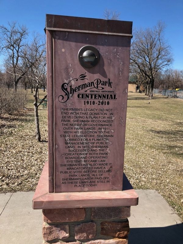
E.A. Sherman Devoted his life to creating and promoting a park system in Sioux Falls. After unsuccessfully lobbing for the creation of a park commission, Sherman began his legacy with a 1907 election to the city council. . . . — — Map (db m131978) HM
Near North Grange Avenue south of West 2nd Street, on the right when traveling south.
The Renovation and Restoration of the
Shoto-Teien Japanese Gardens
Terrace Park at Covell Lake
Sioux Falls, South Dakota
The Terrace Park Japanese Gardens were originally created from 1926 to 1936. In 1984, after years of neglect, a . . . — — Map (db m207213) HM
On Sunday July 11, 1920, at McKennan Park, several thousand people attended the first concert of the Sioux Falls Municipal Band. A year earlier, in the first city election allowing women to vote, citizens approved a proposal to support a city . . . — — Map (db m113433) HM
Side 1 Between about 1913 and 1920, adventurous children and adults could enjoy exciting rides on a giant plank-and-timber, tin-lined slide which began near this marker. The slide was the creation of Edwin A. Sherman, a
local real estate . . . — — Map (db m139332) HM
Near South 4th Avenue west of East Park Drive, on the right when traveling south.
Led by E.A. Sherman, various park features and gardens began to appear with its official opening in 1908. This included a Caretaker's Lodge. The City Greenhouse was added in the 1920's as McKennan Park became a showcase of floral innovations. . . . — — Map (db m238271) HM
Near South 2nd Avenue north of East 23rd Street, on the right when traveling north.
The Helen McKennan Home was built by Col. Melvin Grigsby on land platted as part of the Boulevard Addition in 1883. The elegant, two and a half story Italiante structure sat on what became the northwest corner of the Park. Helen McKennan lived there . . . — — Map (db m238269) HM
Near South 2nd Avenue north of East 24th Street, on the right when traveling north.
The original McKennan Park pond was constructed as a small lake in 1908 by E. A. Sherman to beautify the park. It served as a "swimming hole" until 1929 when a permanent concrete wading pool was built south and west of the Sunken Gardens. This . . . — — Map (db m238274) HM
Near South 4th Avenue, 0.1 miles south of East 21st Street, on the right when traveling south.
Built in 1931 by Park Employees, the Miniature Rock Garden and Village was located northeast of the Formal Gardens near the Park Greenhouses. Boasting a miniature town with homes, a church, light and power buildings, a model railroad, and a goldfish . . . — — Map (db m186529) HM
Near South 2nd Avenue north of East 26th Street, on the right when traveling north.
The ball diamond was built shortly after the park opened. It served as the city's sole baseball field and home to both local amateur and professional teams. 'Fly balls', however, proved to be dangerous to the public in the adjacent wooded picnic . . . — — Map (db m238278) HM
Near South 2nd Avenue north of East 23rd Street, on the right when traveling north.
The Sunken Garden was constructed in 1936 and hosted a sundial, fountain and sculpture of Hansel and Gretel. The manicured garden displays included an adjacent McKennan Park floral nameplate throughout the 1930s - 1950s, which was brought back in . . . — — Map (db m238270) HM
Near South 4th Avenue south of East 21st Street, on the right when traveling south.
The first tennis courts in McKennan Park were constructed in 1909. These grass and clay courts were in use until 1945 when the tennis courts were rebuilt out of concrete. McKennan Park became well known for both recreational and championship tennis . . . — — Map (db m238268) HM
On South Phillips Avenue, 0.1 miles south of East 14th Street, on the right when traveling north.
The Lyon Family Home
The home, pictured above, was built by Jacob and Katie Schaetzel in 1881, on the northeast corner of 11th Street and Dakota Avenue. Jacob Schaetzel was village president, and later was elected as the first mayor of . . . — — Map (db m199677) HM
On South Phillips Avenue south of East 14th Street, on the right when traveling north.
The Soldier Statue & Cannon
On Friday, September 4, 1904 a statue of a soldier, known as the "American Volunteer," and a surplus cannon were placed by the Joe Hooker Post of the Grand Army of the Republic, a Civil War veterans organization, . . . — — Map (db m199670) HM
On River Road, 0.1 miles north of East 10th Street (State Highway 42), on the right when traveling north.
Visible to the southeast are the 10th Street Bridge, the Viaduct and the area known as Fawick Park. The bridge and viaduct were originally constructed in 1889 serving as a link between east Sioux Falls and the downtown area. The area to the south of . . . — — Map (db m184846) HM
On River Road, 0.1 miles north of East 10th Street (State Highway 42), on the right when traveling north.
This is the site of the earliest documented river crossing, used both by Native American peoples as well as Euro-American pioneers traveling the Yankton Trail. Prior to 1926, below the 9th Street Parking Ramp to the Northwest, a small island divided . . . — — Map (db m184843) HM
Near East 8th Street east of North Phillips Avenue, on the right when traveling east.
Early settlers embraced the Big Sioux River for its industrial potential, but the river was also an important recreational amenity
Bring your love to the bridge.
Initial, Attach & Kiss! #sflovelock
The Love Lock Wall
A love . . . — — Map (db m195025) HM
On North Phillips Avenue north of West 5th Street, on the right when traveling north.
The realization of a grand vision to restore the natural beauty of our city’s most historic and important landmark
Falls Park is the city’s historic birthplace. The almost mystical allure of the falls has always been a powerful influence. . . . — — Map (db m124588) HM
Near North Cherapa Place south of East 6th Street.
While the Big Sioux River was primarily of industrial importance to the settlement of Sioux Falls, it also has an equally important history for recreation.
The First Public Report of the Board of Parks Supervisors of 1915-1920 called for . . . — — Map (db m124495) HM
On South 2nd Avenue at South 3rd Avenue, on the right when traveling north on South 2nd Avenue.
Thomas L. Fawick was born in Sioux Falls and attended school here through the fourth grade. His genius was soon revealed. He became an inventor, and in 1906, at the age of 17, Fawick built a rudimentary two-cylinder auto, the Silent Sioux.
Two . . . — — Map (db m192013) HM
Near East 8th Street east of North Phillips Avenue, on the right when traveling east.
At least three bridges have been built to allow passage over the Big Sioux River in this location, ranging from a single span steel truss structure to a three-span reinforced concrete arch bridge.
By the numbers
Total Bridge Length: . . . — — Map (db m195036) HM
On South Lake Avenue north of West 13th Street, on the right when traveling south.
A substantial increase in the number of school age children caused overcrowding at existing city schools and led to the building of Emerson School in 1923. Designed to combine one- and two-story sections, it was completed at a cost of $100,000 and . . . — — Map (db m207157) HM
Through the combined efforts of the Sioux Falls Parks and Recreation Board, the Northern States Power company, and the River Improvement Society (Rise). This bridge is dedicated to the people of Sioux Falls to provide better access to the city's . . . — — Map (db m112815) HM
With a pioneer spirit Hazel O'Connor has continually let the way toward a better Sioux Falls. One of her many special concerns has been the Big Sioux River and the falls, the city's namesake. As a leader of the City Federation of Women's clubs, . . . — — Map (db m112819) HM
On North Mable Avenue at East Walnut Street, on the right when traveling north on North Mable Avenue.
Albert M. Mansor was born in Aramta, a tiny village in Lebanon. At the age of 15, he immigrated to Sioux Falls to work in his uncle's East Side grocery store. After his uncle's death, Mansor was urged to liquidate; instead, he remained and worked to . . . — — Map (db m207162) HM
On North Garfield Avenue at West Bailey Street, on the right when traveling south on North Garfield Avenue.
Soon after this area was platted in 1889, the city of Sioux Falls installed a community well which was located at this spot. It was a source of water for livestock and household use. Local residents referred to it as the "town pump." Here they hand . . . — — Map (db m184689) HM
On 220th Street (County Road 2) 0.3 miles east of 467th Avenue, on the left when traveling east.
In 1915, Mr. and Mrs. Bill Hagensick purchased 14 acres of land here that, in 1917, became Hagensick's Resort. As the automobile gained popularity, thousands of summer fun-seekers sought out the resort. In 1920, it was expanded west of the bridge . . . — — Map (db m181260) HM
On East Main Street (U.S. 385) 0.4 miles north of Museum Drive, on the left when traveling north.
This memorial dedicated to
the young men of the
Civilian Conservation Corps
1933-1942
Made possible by a grant from
”Sarge”
Melvin B. Hermanson
2008 — — Map (db m120159) HM
Near U.S. 385 at Dead Broke Street, on the right when traveling north.
The George S. Mickelson trail follows the old railroad of the abandoned Edgemont to Deadwood line of the Chicago, Burlington, and Quincy Railroad (CB&Q). The railroad was converted to the Mickelson Trail in the Fall of 1998 as part of the Rails to . . . — — Map (db m162782) HM
Near Deerfield Road, 0.6 miles north of Main Street (U.S. 385), on the right when traveling north.
The George S. Mickelson trail follows a raised railroad right-of-way that is the abandoned Chicago, Burlington, and Quincy Railroad (CB&Q). In 1849, construction of the CB&Q began in Aurora, Illinois and by 1864, the CB&Q spanned the 400 miles . . . — — Map (db m155900) HM
On Presidential Trail west of Highway 244, on the right when traveling west.
Thomas Jefferson
“I have learnt to expect that it will rarely fall to the lot of imperfect man to retire from this station with the reputation & the favor which bring him into it.” - First Inaugural Address, March 4, 1801
Born . . . — — Map (db m181435) HM
In Founders Park Plaza the history of the first developed part of Rapid City is literally written in concrete. The Plaza shows the town (in colored concrete) skewed on its foundation (in uncolored concrete), orienting the town toward magnetic north . . . — — Map (db m187541) HM
What is Founders Park Plaza's mission?
1. To mark the location where the founding party camped in 1876 while they laid out Rapid City.
2. To honor Rapid City's founders and pioneers.
3. To educate visitors about the 50 years of Rapid . . . — — Map (db m187537) HM
Castle
This magnificent structure has been constructed out of prehistoric logs, some of which weigh more than 10,000 pounds apiece. The entire castle is composed of more than 300 tons of petrified rock (think 8 full semi-trucks, or 200 . . . — — Map (db m231224) HM
On Main Avenue north of Sixth Street East, on the right when traveling north.
Ole S. Quammen, the mastermind behind the Petrified Wood Park, was born in 1871, his family immigrated to America in 1872 and homesteaded in MN. When Quammen was 23 he became a Watkins Medical Co. distributor which eventually led him to Voltaire, ND . . . — — Map (db m231140) HM
father of Mrs. Harry C. Olson,
the creator and donor of this,
the world's largest
Petrified Wood Park of its kind.
Mr. Quammen's picture is displayed in the museum. — — Map (db m113240) HM
Petrified wood is actually a fossil. and these are estimated to be 20-30
million years old.
The petrification process can take very little time under the right circumstances but the longer the process is given, the harder the rocks will . . . — — Map (db m231496) HM
On Ketterlings Loop Road, 0.7 miles North Cabin Road, on the right.
Across the reservoir, situated on an overlooking bluff, stands a monument to Hugh Glass, fabled pirate turned fur trader and frontiersman. In August of 1823, while on a fur trapping endeavor with the Ashley Fur Company, Glass was attacked by a . . . — — Map (db m152992) HM
On Ketterlings Loop Road, 0.7 miles south of North Cabin Road, on the right.
The little town of Seim slipped below the water and into memory when the Shadehill Dam was built. The town was founded in 1894, named after one of the first pioneer settlers in the area. During its prime in the early 1900s, the town had banks, . . . — — Map (db m152990) HM
On Ketterlings Loop Road, 0.7 miles south of North Cabin Road.
Beginning in 1949, the Bureau of Reclamation began construction on a dam on the forks of the Grand River. Built for the purpose of crop irrigation and flood control, Shadehill Reservoir is a part of the larger Pick– Sloan Missouri Basin . . . — — Map (db m152991) HM
Has been designated a
Registered
Natural Landmark
Under the Provisions of the
Historic Sites Act of August 21, 1955
This site Possesses Exceptional Value
In illustrating the Natural
History of the United States
U.S. . . . — — Map (db m123355) HM
On East 7th Street east of South Main Street, on the right when traveling east.
This park has been given to the children of Winner by George C. "Shorty" McDonald.
He left two-fifths of his estate ($8,000) to the community to build a park for the children. McDonald was 68 years old when he died Jan. 1948. He was orphaned in . . . — — Map (db m234976) HM
Near Levee Street, 0.1 miles south of Pearl Street, on the right when traveling east.
The Missouri flows free for 59 miles below Gavins Point Dam and for 39 miles below Fort Randall Dam. These sections of the national recreational river provide glimpses of the once undammed, unchannelized river that played a major role in America's . . . — — Map (db m189403) HM
The Missouri, the continent's longest river, figures prominently in the unfolding of America's saga. Flowing nearby in its 2,341 - mile course from the Rocky Mountains to the Mississippi, the Big Muddy is not only loaded with sediment but steeped in . . . — — Map (db m232821) HM
144 entries matched your criteria. Entries 101 through 144 are listed above. ⊲ Previous 100