On Broadway (U.S. 20) 0.1 miles west of Town Line Road, on the right when traveling west.
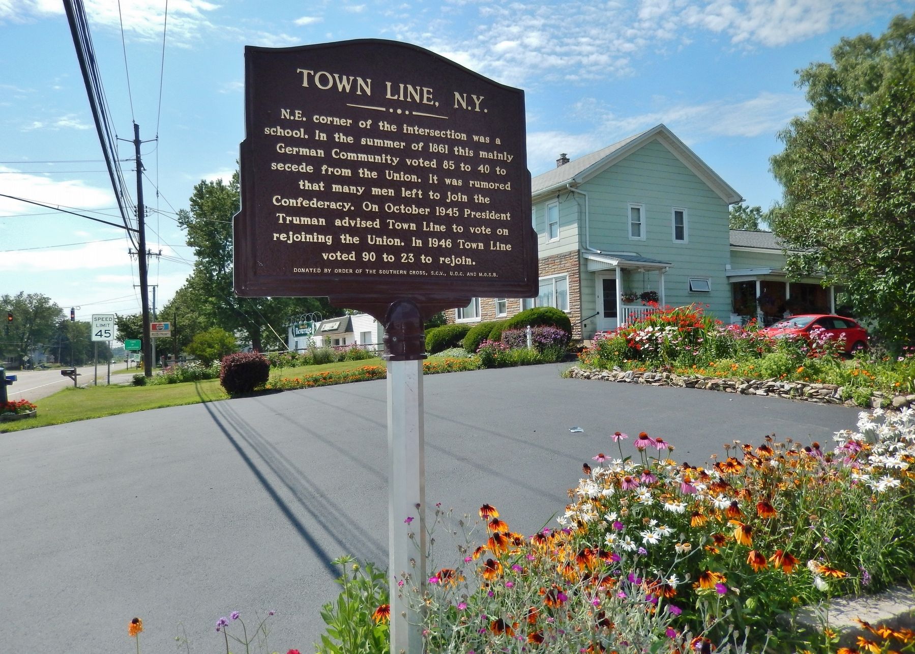
N.E. corner of the intersection was a school. In the summer of 1861 this mainly German Community voted 85 to 40 to secede from the Union. It was rumored that many men left to join the Confederacy. On October 1945 President Truman advised Town . . . — — Map (db m118941) HM
On Bullis Road (County Route 331) at Two Rod Road, on the left when traveling east on Bullis Road.
This monument was erected in 2011 to commemorate the 150th anniversary or the start of the Civil War, April 12th, 1861. More than 620,000 soldiers died by the end of the war in 1865, making it the bloodiest conflict ever engaged by the . . . — — Map (db m133240) WM
On North Buffalo Road (New York State Route 240) at Webster Road, on the left when traveling north on North Buffalo Road.
The Webster Family were early settlers in this community. Erastus Webster served under Secretary of State Seward in the Cabinet of President Abraham Lincoln. He represented the U.S. Gov't during the transfer of the Confederate emissaries Mason and . . . — — Map (db m80546) HM
On North Buffalo Street (County Route 181) at Franklin Street, on the right when traveling north on North Buffalo Street.
[front] Our Honored Dead [right] In memory of the defenders of our country 1861-1865 [back] By valor and sacrifice, through unmeasured suffering and death, they preserved the honor and integrity of the nation and maintained the principle of . . . — — Map (db m80640) WM
On East Main Street (New York State Route 39) at Mechanic Street, on the right when traveling west on East Main Street.
Bright Past, Brilliant Future. You are in the center of the Village of Springville, incorporated in 1834 to provide services for the growing manufacturing activities within the Town of Concord. This location was the former site of the Leland House . . . — — Map (db m80769) HM
On Big Tree Road (U.S. 20A) 0.2 miles east of Four Rod Road (County Route 325), on the right when traveling east.
In Memory of Wales, NY veterans KIA - all wars Revolutionary War War of 1812 Civil War: Bela W. Burzette GAR; James D. Edmonds GAR; Wm. H. Edmonds GAR; William Enos GAR; Henry H. Havens GAR; Richard Leigh GAR; Almon Simmonds GAR; Jared Tiffany . . . — — Map (db m133181) WM
To the memory of the
heroic volunteers of Crown Point,
who gave their lives as a sacrifice
for their country and humanity,
in the suppression of the
Great Rebellion of 1861-1865.
This monument is erected by their
grateful fellow . . . — — Map (db m126316) WM
On Court Street (U.S. 9) at Park Street, on the left when traveling north on Court Street.
John Brown’s body guarded by local citizens rested in this court house on the night of Dec. 6, 1859 on its way to burial at his home in North Elba. — — Map (db m136665) HM
On New York State Route 9N, on the left when traveling south.
One of the earliest common burying grounds of historic Ticonderoga. Memorialized here are many first settlers, early doctors and supervisors, the town’s first State Senator, veterans of the Revolutionary, 1812, and Civil Wars. Last burial of a Civil . . . — — Map (db m11711) HM
On Elm Street (New York State Route 30) at East Main Street (U.S. 11), on the right when traveling north on Elm Street.
The highest United States military decoration, awarded by the President in the name of Congress to members of the armed forces for conspicuous gallantry and intrepidy against the enemy, at risk of life, above and beyond the call of duty. The medal . . . — — Map (db m78914) WM
In memory of the soldiers and sailors of the Civil War who fighting not for themselves but for future generations. Saved the nation. — — Map (db m49978) HM
On 30 at Blowers Road, on the right when traveling south on 30.
Anthonyville
Site of First Brick Home In
Town of Mayfield. Birthplace
of George T. Anthony. Quaker,
Civil War Officer, Governor
State of Kansas. 1876-1879
— — Map (db m46954) HM
On Bridge Street just west of North Main Street, on the right when traveling west.
(left tablet • Revolutionary War & Spanish-American War)In honor of the sturdy pioneers, who fought in the Revolutionary War, making us a free and independent people and of those who in the Spanish-American War served and sacrificed to . . . — — Map (db m147671) WM
On Upton Road, 0.2 miles south of Lear Road, on the left when traveling south.
Birthplace of Emory Upton 1839 - 1881. West Point graduate. U.S. Army General and Civil War veteran. Influential military author & stategist — — Map (db m126158) HM
A native Batavian who once lived at No. 4 Liberty Street. Charles Franklin Rand is officially recognized by the Congress of the United States as the first person to answer President Lincoln's appeal for volunteers in the Civil War on April 15, 1861. . . . — — Map (db m39635) HM
On East Main Street (New York State Route 5) at Ellicott Street (New York State Route 63), on the left when traveling east on East Main Street.
[front] Major General Upton In memory of the soldiers sailors and marines of Genesee County. [right] Battles of World War - Apr.6, 1917-Nov.11, 1918 Cambrai · Somme · Lys · Aisne · Cantigny · Belleau Wood · Chateau-Thierry · Montdidier-Noyon · . . . — — Map (db m83077) WM
On Main Street (New York State Route 5) at Wolcott Street, on the right on Main Street.
In Memory
Of The
Soldiers
Of
Le Roy
Rebellion
William C. Allen ·
John W. Amlong ·
Alexander L. Anderson ·
Benjamin Anderson ·
David D. Anderson ·
Wilber H. Anderson ·
James Avery ·
Samuel Avery ·
Samuel Avery 2nd · . . . — — Map (db m231465) WM
On Akron Road (County Route 11) at Gilmore Road, on the right when traveling west on Akron Road.
Son of William and Elizabeth Parker, born in a log cabin overlooking the water-falls, at Indian Falls, N.Y., then part of the Tonawanda Indian Reservation. Volunteered into the army, and became General Grant's Military Secretary. He was . . . — — Map (db m76082) HM
On North Main Street south of Court Street, on the right when traveling north.
This tablet is erected by the people
of the County of Herkimer
in grateful remembrance
of the valiant and distinguished services
of the Thirty-Fourth Regiment
New York State Volunteer Infantry
in the War of the Rebellion
under the . . . — — Map (db m54320) HM
On East Main Street, on the left when traveling west.
Citation:
On board the U.S.S. Minnesota in action during the assault on Fort Fisher, 15 January 1865. Landing on the beach with the assaulting party from his ship, S/man Bass advanced to the top of the sand hill and partly through the breach . . . — — Map (db m131125) HM
Near East Main Street (New York State Route 169) at John Street, on the right when traveling west.
Four score and seven years ago our fathers brought forth on this continent, a new nation, conceived in Liberty, and dedicated to the proposition that all men are created equal.
Now we are engaged in a great civil war, testing whether that nation, . . . — — Map (db m138674) HM WM
On Main Street at Riverside Avenue, in the median on Main Street.
This cannon
was in actual service
during the War of the Rebellion
and was erected by the
George W. Flower Post No. 306
Grand Army of the Republic
in memory of
Captain Jerome Cooper
and his
generous patriotic family,
as well . . . — — Map (db m181190) WM
On Public Square (New York State Route 3/12) at Washington Street, in the median on Public Square.
In grateful memory of the
Soldiers and Sailors of
Jefferson County
who fought or fell in defense of
the Union and the freedom of man.
This monument to witness
that these dead have not
died in vain and that
through them,
under God, . . . — — Map (db m110124) WM
On Clinton Street at Livingston Street, on the right when traveling north on Clinton Street.
This house was the former home of the Brooklyn Excelsiors, baseball champions of the United States in 1860. Constructed in 1851, the building was once the Jolly Young Bachelors clubhouse. The Bachelors evolved into the Excelsiors baseball team. One . . . — — Map (db m181657) HM
In January 1863, an historic three-day celebration of the Emancipation Proclamation occurred here at the Bridge Street African Wesleyan Methodist Episcopal Church. On Wednesday night, New Years Eve — known as "watch night" in the church's . . . — — Map (db m242927) HM
On Fulton Street at Cumberland Street, on the right on Fulton Street.
This park is named for Dr. Theodore Ludyard Curler (1822-1909) a prominent local minister born in Aura, New York. Educated by his mother, Cuyler graduated from Princeton College in 1841 and Princeton Theological Seminary in 1846. He served as a . . . — — Map (db m242722) HM
On Lafayette Avenue at Fulton Street, on the right when traveling east on Lafayette Avenue.
Fowler
( plaque )
Erected by the City of Brooklyn
In Honor of the Services Rendered by the 14th. Regt. N.Y.S.M.
1861 — 1865
Bull Run · Binns Hill · Spottsylvania, Aug.1862 · Fredericksburg · Mine Run · Rappahannock Station · . . . — — Map (db m104898) WM
Near Sterling Drive south of General Lee Avenue, on the right when traveling south.
Based upon a French design, the Model of 1857 “Napoleon” was a bronze gun capable of firing a 12 pound shot nearly one mile. Although few were produced prior to 1861, large numbers of the Napoleons were ultimately employed by both sides during the . . . — — Map (db m104516) HM
On Sterling Drive at Pence Street, on the left when traveling west on Sterling Drive.
‘These mortar shells were the most disgusting, low-lived things imaginable,’ W.W. Blackford, a Confederate Engineer. Developed in an age of massive innovation in ordnance technology, the 13-inch seacoast mortar became one of the most . . . — — Map (db m22897) HM
Then Captain, Corps of Engineers, U.S.A.
resided on this site
1841-1846
Presented by
New York Division
United Daughters of the Confederacy — — Map (db m107671) HM
On Sterling Drive, on the left when traveling south.
This was the standard smoothbore fieldpiece of the Civil War. Our specimen is a rare early model distinguished by its handles as one of the first thirty-six made. — — Map (db m21666) HM
On Sheridan Loop, on the right when traveling east.
These thousand pound cast iron balls fit the huge gun in the park just outside the fort’s main gate. The 20-inch model of 1864 was experimental; the largest standard seacoast gun in use during our Civil War was the 15-inch Rodman. — — Map (db m29650) HM
Near Monitor Street, 0.2 miles south of Nassau Avenue.
Erected by the people of the State of New York to commemorate the battle of the Monitor and Merrimac March 9th 1862 and in memory of the men of the Monitor and its designer John Ericsson — — Map (db m241404) HM
On Battle Avenue, on the left when traveling north.
The City of New York enlisted one hundred and forty eight thousand soldiers in aid of the war for the preservation of the Union and the Constitution. A.D. 1861-65. Right Side of Monument: Ever remember how much of national prosperity is due to . . . — — Map (db m13257) HM
On Linden Avenue, on the right when traveling south.
Erected by the Drum and Bugle Corps of the 13th Regt. N.G., S.N.Y., in memory of Clarence D. MacKenzie, born Feb. 8, 1849, Died at Annapolis, MD., June 11, 1861, aged 12 yrs 4 mos 3 dys Back of Monument: This young life was the first offering . . . — — Map (db m13314) HM
Company A. 71st Reg
N.Y.S.M.
Who fell mortally wounded
at the first battle
of Bull Run
July 21, 1861.
Died at Richmond, VA
Aug 1, 1861
Aged 22 years
— — Map (db m149407) WM
On Grand Army Plaza near Plaza Street West, on the right when traveling south.
Lieutenant Colonel Corps of Engineers, U.S.A.
Born at Cold Spring N.Y. January 8, 1830
Died at Newport R.I. August 8, 1882
Everything with him was subordinated to duty.
Graduated at West Point, 1850. Corps of Engineers U.S. Army. . . . — — Map (db m108906) HM WM
On High Street at Cataract Road, in the median on High Street.
They need no monument those who fought and died for their country, but their country ever needs the memory and inspiration of their example. In honor of the boys in blue. — — Map (db m66874) WM
On North State St (State Highway 26) at County Road 14, on the left when traveling north on North State St.
South Side (Top) - Erected 1883 (Base) - FIVE FORKS
South side names: L. Madrid • Thomas Allen • Joseph Butts • A.W. Allen • Seth Squires • Fred. Koster • John Major • William Barnes • A. Dunaway • C.H. Perkins • M. Sprague • . . . — — Map (db m50519) HM
On Main Street (New York State Route 5) at Genesee Street, in the median on Main Street.
In the winter of 1865, the Soldiers' Monument Association of Avon was formed with Calvin Knowles, president, John Marsh, secretary, Stephen Hosmer, treasurer. Their purpose was to raise sufficient funds to erect a memorial
that recognized the . . . — — Map (db m145705) HM
On Ossian Street (New York State Route 36) at Spruce Street, on the left when traveling west on Ossian Street.
(front)
From
Fort Sumpter
to
Appomattox
G.A.R.
(right)
1861
Let us have Peace
Grant
1865
Fraternity
(rear)
With malice
towards none,
with charity
for all.
Lincoln . . . — — Map (db m75797) WM
Near Court Street at Avon Road (New York State Route 39).
Brevet Major General James S. Wadsworth, October 1807 - May 1864. Mortally wounded at the Battle of the Wilderness. He believed in the Union, Emancipation, and the Genesee Valley, and for those he gave his life. — — Map (db m117013) WM
On Rorbach Lane at Lima Road, on the left when traveling east on Rorbach Lane.
Site of Camp Union ——·•·—— In a regimental camp near this spot, more than 700 men from this Valley were trained for Civil War service under the direction of Col. John Rorbach of Geneseo. They became Companies A-G of . . . — — Map (db m117008) HM
On Chapel Street (U.S. 408) at Stanley Street, on the left when traveling west on Chapel Street.
John W. Powell rank of Maj. - fought in Civil War, led first Grand Canyon Exped. in 1869 - helped start U.S. Geological Society & Nat. Geographic Society. — — Map (db m87707) HM
On State Street (County Route 24) 0.4 miles south of New York State Route 70, on the left when traveling south.
Hall built 1888 by local Grand Army of the Republic Post. Named for brothers James & Cordenio Thompson who died in Civil War. Closed 1926. — — Map (db m245756) HM
On Parade Grounds Entrance Road, 0.6 miles north of Portage Street (New York State Route 436).
This picnic area once served as the camp and parade grounds for two Civil War volunteer units. The 14-acre camp, hastily constructed in mid-August 1862, consisted of officer's headquarters, two mess halls, and ten quarters for soldiers. Colonel . . . — — Map (db m75832) HM
On Parade Grounds Entrance Road, 0.6 miles north of Portage Street (Route 436), on the left when traveling west.
First New York Dragoons
130th New York Volunteer Infantry
Organized on this field Aug. 11, 1862
Left this field September 2, 1862
Colonel Alfred Gibbs
Lieutenant Colonel TJ. Thorpe
Major Rufus Scott
Captured
Prisoners . . . — — Map (db m75806) HM WM
On South Peterboro Street (New York State Route 13) at Seneca Turnpike (New York State Route 5), on the right when traveling north on South Peterboro Street.
1861-1865
Lenox and Canastota's
Tribute to Their Heroes.
Erected A.D. 1907
(dates on monument)
1776-1783
1812-1815
1846-1848
1898 — — Map (db m149176) WM
On Main Street (New York State Route 80) west of Railroad Street (Route 0.1), on the right when traveling west.
(Front Side)
The People of New Woodstock built this monument in honor of the brave men whose names it bears, who defended their country in war, and who found here a birthplace, home, or grave.
Soldiers of the War of the Revolution . . . — — Map (db m144381) WM
Near Owens Road north of South Avenue, on the right when traveling north.
Soldiers' Memorial Tower
has been placed on the
National Register of
Historic Places in 1994
by the United States
Department of the Interior — — Map (db m151513) HM WM
On North Main Street (New York State Route 65) 0.2 miles south of Pride Street, on the right when traveling south.
1st Sgt. Co. G, 8th NY Cavalry, awarded Medal of Honor for capture of flag at Battle of Waynesboro, VA, March 2, 1865. Interred Here. — — Map (db m200253) WM
On Genesee Street, 0.1 miles south of West Main Street (Route 33), on the right when traveling south.
St. Mary's Hospital Opened in September 1857 by the Sisters of Charity from Emmitsburg, Maryland. Cared for over 3000 sick and wounded Civil War Soldiers. — — Map (db m101158) HM
On Stutson Street at River Street, on the left when traveling east on Stutson Street.
Port of the Genesee, New York. Original artwork by Christopher Blossom. Oil on Canvas 34" x 60" Commissioned by the law firm of Harris Beach and Wilcox. The Story of the Painting In 1990, the law firm of Harris Beach and Wilcox commissioned . . . — — Map (db m90429) HM
The upriver ports of Carthage and Kelsey's Landing were stopping places for boats bound for Canada. Escaped slaves arrived in Rochester via the "Underground Railroad" and looked for a friendly captain to take them across the lake and deliver them . . . — — Map (db m90608) HM
On West Main Street at North Plymouth Avenue, on the right when traveling west on West Main Street.
Hundreds of runaway slaves made their way through Rochester and Monroe County to freedom in Canada along a network of secret stops known as the Underground Railroad. Many of the stops were in private homes, businesses and farm buildings. Rochester's . . . — — Map (db m156210) HM
On Alexander Street south of East Avenue (New York State Route 96), on the right when traveling south.
"The story of Frederick Douglass hopes and aspirations and longing for freedom has been told - you all know it.
It was a story made possible by the unswerving loyalty of Anna Murray."
Rosetta Douglass Sprague . . . — — Map (db m231613) HM
This memorial has no identifying text other than a short excerpt from Theodore O'Hara's poem, Bivouac of the Dead
On Fame's eternal camping ground
their silent tents are spread,
And Glory guards with solemn round
the bivouac of the . . . — — Map (db m70733) WM
On South Avenue, 0.2 miles north of Rockingham Street, on the left when traveling north.
Underground Railroad Sites
Rochester's proximity to Lake Ontario afforded runaway slaves a direct route to freedom in Canada. Hundreds of runaway slaves were "conducted" from one "station" to another along this secret network of escape routes . . . — — Map (db m65156) HM
On this site in 1862 was erected Camp Fitz-John Porter as a recruit camp for Civil War soldiers. Named after a Union general, it was the initial training ground for Monroe County's 108th and 140th New York infantry regiments and Mack's 18 . . . — — Map (db m115287) HM
On Crittenden Boulevard at Castleman Road, on the left when traveling west on Crittenden Boulevard.
Camp Hillhouse Col. Crooks' 8th N.Y. Vol. Cav. & Irish Brigade of 105th N.Y. Vol. Inf. used this county fairground site as Civil War recruiting station, 1861-62. — — Map (db m115301) HM
On East Henrietta Road (New York State Route 15A) at Lehigh Street, on the left when traveling south on East Henrietta Road.
( top photo) Jacob Stull Galentine (1835-1905) enlisted with the New York 136th Volunteers at age 28. He was born and grew up in Rush, the son of John and Isabella Stull Galentine. This 1888 photograph was taken at the NY 126th monument . . . — — Map (db m142360) WM
On Lake Road South (New York State Route 19 at milepost 3.7), 0.1 miles south of Shumway Road (County Route 225), on the right when traveling south.
Milo L. Starks Home of Civil War hero, led 140th NY infantry on Little Round Top 7/2/1863 wounded 4 times, killed at Laurel Hill, May 14, 1864 — — Map (db m109960) HM WM
On Mohawk Street west of Michigan Avenue, on the right when traveling east.
"Bromley" Hoke (1847-1913) Canajoharie native served in 54th Mass. Regt, one of nation's 1st black troops to fight in the Civil War — — Map (db m137292) HM
In Memory Of
The 115th and 153rd Regiments N.Y. Volunteers of the Civil War.
The 115th (Iron Hearted) Regiment was organized and mustered Into U.S. service Aug. 29, 1862, at Fonda, N.Y. and honorably discharged at Raleigh, N.C., June . . . — — Map (db m59526) HM
On East Main Street (New York State Route 5), on the right when traveling east.
Transferred to Soldiers and Sailors Memorial Park by Alonzo Smith Post No. 356 G.A.R Dept. of N.Y. C.W. Scudder, Com., C. W. Lambert, Adj. 1922
This gun was in active service during the Civil War — — Map (db m137988) WM
On Main Street at Prospect Street, on the right when traveling north on Main Street.
In honored memory of the
Farmingdale area residents
who served during
the American Civil War
1861-1865
John Allen · Thomas Brawley · Andrew Conklin · Josiah Howell Culver, M.D. · Philip Darby · William Fleet · John Gannon · Platt . . . — — Map (db m126858) WM
On Sunrise Highway (State Highway 27) at Madison Avenue, on the right when traveling east on Sunrise Highway.
From USS Hartford - flagship
of Admiral David Farragut
during Battle of Mobile Bay
August 1864
Presented to Freeport July 4, 1902 — — Map (db m133522) HM
On Forest Avenue at School Street, on the left when traveling south on Forest Avenue.
In memory of John E. Miller Private – 2nd New York Calvary Born Glen Cove, New York 1841 Died Andersonville Prison, Georgia 1864 — — Map (db m65163) HM
Presented to the
Village of
Rockville Centre
through Rockville
Centre Council No 8
D.of.L by the War Dept
30 Pdr Parrott Gun
Weight 3475 Lbs
Did good service during
the Civil War on
Gun Boat Neptune
Mounted May . . . — — Map (db m114798) HM
Near State Street south of Battery Place, on the right when traveling south.
Rising to an imposing 150 feet from a bluff overlooking the Hudson River, this monument to General Grant is the largest mausoleum in America. Constructed of over 8,000 tons of granite, the great tomb was built to honor the Civil War general who . . . — — Map (db m207520) HM
Near West Street near Chambers Street, on the right when traveling south.
As one of the most famous and respected black abolitionist leaders of the 19th century, Frederick Douglass inspired many people through his courage and determination.
Frederick Bailey was born a slave in February 1818 on Holmes Hill Farm in . . . — — Map (db m168927) HM
On Riverside Drive at W 106th Street, on the left when traveling north on Riverside Drive.
This bronze equestrian sculpture of military officer, educator, journalist, and public servant Franz Sigel (1824-1902) is by the distinguished sculptor Karl Bitter (1867-1915). Sigel is also honored with a park named for him, which is . . . — — Map (db m53973) HM
On Bowery north of Broome Street, on the right when traveling north.
This is the former site of undertakers McGraw and Taylor, where the body of John Brown was secretly prepared for burial. Executed on December 2, 1859, for the raid on Harper’s Ferry, Virginia, the radical abolitionist had tried to ignite an armed . . . — — Map (db m179403) HM
On Fifth Avenue at West 59th Street, on the right when traveling south on Fifth Avenue.
The William Tecumseh Sherman monument by August Saint-Gaudens (1848-1907) was the artist’s last major monument and his crowning achievement. Architect Charles McKim designed the granite base for the monument and Saint-Gaudens brought on . . . — — Map (db m126256) HM
On West 3oth Street at Ninth Avenue, on the right when traveling east on West 3oth Street.
On this site stood, in 1861, the station of the Hudson River Railroad
The first passenger to use it was Abraham Lincoln who came to New York on February 19, 1861, on the way to his inauguration as President of the United States . . . — — Map (db m113057) HM
459 entries matched your criteria. Entries 101 through 200 are listed above. ⊲ Previous 100 — Next 100 ⊳