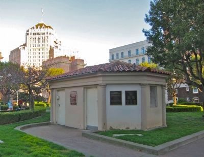
Huntington Park
On this site in 1872, General David D. Colton, a railroad attorney, built one of the most elaborate residences ever seen in San Francisco. The classic white wooden mansion featured an entry flight of marble steps leading to a . . . — — Map (db m63532) HM
The Alcatraz Gardens
Alcatraz would be a barren rock were it not for human presence. Despite the lack of soil and water, people have planted and maintained gardens on The Rock for 150 years. In the nineteenth century, the army imported soil to . . . — — Map (db m228554) HM
The main idea is, to crown the ridges, border the boundary fences, and cover the areas of sand and marsh waste with a forest. … In order to make the contrast from the city seem as great as possible, and indirectly accentuate the idea of the power . . . — — Map (db m176592) HM
Meet a Zoo Original
The swamp gum eucalyptus tree standing before you was one of the original lake-shore plantings at the Zoo, planted sometime around 1925. There are only about 20 of these trees known to exist in California, and this is . . . — — Map (db m230441) HM
Golden Gate National Recreation Area
Lands End
Carpet bed designs were created with flowers and carefully trimmed grasses, hedges, and moss. They were a standard feature in Victorian gardens. The elaborate plantings at Sutro Heights were mostly . . . — — Map (db m210714) HM
This site was the location of Sutro’s glass conservatory, built to shelter exotic plants from the local coastal fog and harsh winds. Flowers from around the world thrived inside the greenhouse along with infant shrubs and mosses used to create the . . . — — Map (db m210876) HM
Redwood City was an important center for early aviation and Stanford Redwood City is located on what was once an airfield. Silas Christofferson, a visionary young pilot and engineer, bought Michael Lynch’s flower field in early 1916 and built . . . — — Map (db m206589) HM
Nurseryman Michael Lynch bought the property that is now the Stanford Redwood City campus in 1898. Lynch was best known for growing violets and sweet peas for sale as cut flowers and in seed packets. In 1901, he was hired by Jane Stanford to . . . — — Map (db m206591) HM
Age Estimated - 1,860 Years
Height:
Before Top Broke - 225 Ft
In 1954 - 137 Ft
Diameter at Base - 14 Ft
Access courtesy of California Water Service — — Map (db m202567) HM
The site of the Central Park is possibly the sole surviving example of the late nineteenth century estates once so numerous on the Peninsula.
Charles B. Polhemus, Director of the San Francisco & San Jose Railroad and founder of Central San . . . — — Map (db m28712) HM
This authentic historic oriental garden and tea house was first developed in the 1880's by Peninsula pioneer Henry Bowie. The property later became part of the Eugene de Sabla estate. Joan and Achille Paladini, current owners have restored the . . . — — Map (db m93312) HM
Planted in the 1930's, this magnificent stand of pines is a treasure in Lompoc's landscape. Rare and historic, these trees receive global recognition for their beauty. — — Map (db m67214) HM
Black Walnut Trees planted about 1885 by William A. Swope, Son-In-Law of Benjamin Campbell, and daughters Alda Swope Blaine, Ethel Swope Davis, and Lena Swope French. — — Map (db m24234) HM
Gilroy’s strategic location contributed to great economic growth beginning in the 1850s.
Inset Images:
In 1870 James Culp was a tobacco grower and owned a cigar factory. Over one million cigars were rolled and shipped monthly all . . . — — Map (db m219074) HM
In the rapidly urbanizing Silicon Valley, open space is precious. Your voice and your vote help protect the regional greenbelt that provides us all with clean air and water, climate change resilience, and nearby opportunities to unplug and connect . . . — — Map (db m203020) HM
The original Coast Redwood tree was planted
by our 26th President Theodore Roosevelt on
May 11, 1903. This majestic redwood was
located on the southwest corner of Campbell
Avenue at Winchester Boulevard. It stood in
that location, growing to a . . . — — Map (db m154876) HM
On November 8, 1789, Don Gaspar De Portola and his expedition in search of Monterey Bay, camped beside San Francisquito Creek near a century-old redwood tree long a landmark for the Indians. The tree named El Palo Alto, became a symbol for the city . . . — — Map (db m92466) HM
Pellier Park is all that remains of the City Gardens Nursery, established by Louis Pellier in 1850. Here with, his brothers, Pierre and Jean, Louis introduced “la petite D’Agen,” the French Prune, during the winter of 1856-1857. I was this variety . . . — — Map (db m232982) HM
The Northern California Black Walnut trees seen along this highway owe their existence to horticulturist Horace G. Keesling of San José. While passing this way by camp wagon on a blistering summer day in 1900, Keesling could find no roadside tree . . . — — Map (db m52138) HM
During the later 1800s, the developing Santa Clara Valley demanded an increase in farm products. California settlements needed wheat and produce to feed growing Gold Rush populations. When the Transcontinental Railroad of 1869 linked the valley to . . . — — Map (db m219207) HM
On this site in 1852 Charles LeFranc made the first commercial planting of fine European wine grapes in Santa Clara County and founded Almadén Vineyards. LeFranc imported cuttings from vines in the celebrated wine districts of his native France, . . . — — Map (db m2580) HM
A late Victorian example of simplified Italianate architecture, the Chiechi House was built in approximately 1876 by John and Jane Campbell. In 1913 the house, at 820 Northrup Avenue, was purchased by Michele Chiechi. Prominent valley orchardists, . . . — — Map (db m52181) HM
Old Adobe Wall
built in 1822
Adobe apartment & work shops
with veranda -corridor &
tilted roof faced the
mission patio
Olive Trees
planted in 1822
mark line of old south wall
of adobe apartment. — — Map (db m195455) HM
James Lick was born in Pennsylvania in 1796. Lick came to San Francisco in 1848 after a successful career as a piano builder in South America. Shrewd real estate investments at the time of the Gold Rush made Lick the richest man in California by . . . — — Map (db m220214) HM
From the winery that bears the name of Paul Masson, premium wines and champagne have flowed continuously since 1852, even during Prohibition under a special government license. Twice partially destroyed by earthquake and fire, the original sandstone . . . — — Map (db m2625) HM
This ancient native Blue Oak (Quercus douglasii) is unique in its size. Its numbers are now greatly diminished as settlers cut them for firewood and fencing. It is found in the rolling foothills of Santa Clara Valley and the western foothills of the . . . — — Map (db m195466) HM
In the Fall of 1992 this Sugar Pine (Pinus lambertiana) was cut at the Dinkney Creek Campground in the Sierra National Forest. When stressed by several years of drought, the tree died after it became infected by the disease "Blister Rust." After the . . . — — Map (db m195468) HM
Historic Landmark
1914
Built by Robert & Ada Paget
”Tower House”
Pagets were flower bulb and poultry farmers who raised three children here.
The Museum of Art & History — — Map (db m208454) HM
Named for Charles Henry “Mountain Charlie” McKiernan, who was one of the first white settlers in the Santa Cruz Mountain area. One of the largest trees of its species, this Sequoia sempervirens was originally over 300 feet high. The tree . . . — — Map (db m53479) HM
July 14, 1769, an expedition led by Don Gaspar de Portola left San Diego to rediscover Vizcaino's "Lost Port of Monterey". The expedition reached but failed to recognize Monterey Bay, traveled north, and discovered San Francisco Bay November 4, . . . — — Map (db m86462) HM
This facility is dedicated to the men and women,
who battled the 1992 Fountain Fire,
and those who have worked and are working
to restore this forest to a healthy and productive part
of the local ecosystem.
During the dangerous salvage . . . — — Map (db m13741) HM
It’s hard to imagine the roar of a sawmill in this quiet valley...
But the foundations and saw wheel in front of you are testament to a small sawmill at Sims. If you look closer, you can even make out a log pond barely visible in the brush to . . . — — Map (db m69841) HM
This water tank is one of only a few historic remains that help tell the Sims story...
The story starts around 1902 when the first sawmill at Sims was built. During this time, logs were transported to the sawmill by horses and steam donkeys. . . . — — Map (db m69842) HM
In 1852 a pack trail was blazed from Sierra Valley over the summit to the placer mines of the North Yuba. Originally packers transported hay but within a few years this trade included beef, butter, barley, oats, hogs, and poultry.
On April 24, . . . — — Map (db m99627) HM
Sierra Valley was discovered in 1851 by James P. Beckwourth, a mountain man and entrepreneur who was searching for a northern route across the Sierra Nevada. The valley had been sighted a year earlier by prospectors exploring the nearby Sierra . . . — — Map (db m65990) HM
The earliest settlers arrived in the Loyalton area in the late 1850s, where they stopped in the lush valley on their way to the Sacramento Valley. Founded in the 1850s as Smithneck, the community had raised a great amount of money for the Union . . . — — Map (db m66035) HM
Hallie Morse Daggett was a refined woman educated in San Francisco, however, her deep love for her childhood home at the Black Bear Mine near Sawyers Bar drew her back to the mountains. She knew how to hunt, fish, ride, trap and shoot early in life . . . — — Map (db m57944) HM
Named after John D. Tennant, an official of the Long Bell Lumber Co. Besides the store that is still here, the town had a church, post office, library, hotel, skidsshacks, schools, and a roundhouse at the height of logging operations. Trains were . . . — — Map (db m99900) HM
In 1913, Hallie Daggett accepted the job at the Eddy Gulch Lookout, entering history books as the Forest Service’s first woman lookout (1913-1927). At a time when men dominated the workplace, this act took special courage, self-confidence, and a . . . — — Map (db m151909) HM
Welcome to the Weed Centennial Plaza
This memorial was designed and built by the proud citizens of Weed and dedicated on September 9, 2001 as a birthday gift to the City.
You are standing next to several of the 3500 bricks salvaged from . . . — — Map (db m176560) HM
This famous Black Walnut tree has provided the nuts for starting over 100 walnut groves in California. It gave shade for travelers and their teams who enjoyed the Wykoff Ranch hospitality of the cool water well nearby. It is said to have been . . . — — Map (db m91457) HM
In 1842 John R. Wolfskill arrived here loaded with fruit seeds and cuttings. He was a true horticulturist and became the father of the fruit industry in this region. In 1937 Mrs. Frances Wolfskill Taylor Wilson, his daughter, bequeathed 107.28 . . . — — Map (db m40132) HM
The petrified forest, dating from the Eocene Period, is the only known example of a petrified forest in California. Its size, scope and variety of petrification is unique in the world. Opalized wood, obsidian, quartz crystal, petrified coral and . . . — — Map (db m175865) HM
James B. Armstrong
Colonel James B. Armstrong came to California from Ohio in 1874 as a land investor. He purchased land in these forests, eventually developing a deep appreciation for the redwoods. Witnessing the alarming rate of . . . — — Map (db m107311) HM
Luther Burbank was born in Massachusetts on March 7, 1849 and arrived in Santa Rosa in October 1875. In 1884 he purchased four acres surrounding this site as a place for horticultural experiments. Here he lived and worked until his death on April . . . — — Map (db m12590) HM
In This Garden 1881 - 1926 Luther Burbank wrought with living plants to bring the world greater fertility, wealth and beauty developing new varieties which produced better fruits and more beautiful flowers. — — Map (db m159543) HM
The California Gold Rush of 1849 and San Francisco's Earthquake of 1906 spurred expansion, rebuilding and extensive timber processing in California.
Sturgeons Mill is a fine example of 1800's steam powered technology, providing lumber for early . . . — — Map (db m102509) HM
The gentleman upon this rock is Count Agoston Haraszthy, the Hungarian nobleman who founded Buena Vista Winery in 1857. He is now known as the Father of California Viniculture - as he did more than any other single person to create our remarkably . . . — — Map (db m207724) HM
Across this creek, and extending for several miles were the vineyards and home of our Count. In 1857 he had acquired 750 acres from Julius K. Rose, a San Francisco real estate investor for $11,500. The property was wedged between two flanks of the . . . — — Map (db m231504) HM
The Buena Vista Vinicultural Society (BVVS) was established in 1863. It was the first of its kind – a corporation dedicated to expanding and modernizing winemaking. It enabled the continued expansion of Sonoma viticulture and the Buena Vista Winery, . . . — — Map (db m231231) HM
In 2007, Buena Vista's founder, Agoston Haraszthy de Mokesa (1812-1869) was inducted into the Culinary Institute of America's Vintners Hall of Fame. It was a tribute not only to his pioneering vision, but also to those throughout the winery's . . . — — Map (db m231220) HM
Marker One:
Father Junipero Serra: 1713 - 1784
Founder of the Missions of California, this Franciscan priest was the first to bring the grape to California, beginning with the first vineyard planted at Mission San Diego in 1779. His . . . — — Map (db m231450) HM
At the beginning part of the 19th Century, Northern California was a wild land full of Native American tribes. Chief Solano (born Sem-Yeto) was a member of the Suisun tribe, born around 1800. In 1810, he was baptized under the name "Francisco . . . — — Map (db m231448) HM
As an immigrant himself, our Count Haraszthy was a tireless supporter of another immigrant group to America: the Chinese. He believed them to be hard-working and honest. When he began Buena Vista Winery he employed 150 Chinese workmen to do all the . . . — — Map (db m231243) HM
Marker One:
St. Vincent of Saragossa: ? - 304 AD
St. Vincent of Saragossa died in the year 304, martyred during the last persecution of Christians by Roman Emperor Maximilian. By the early middle ages he had been adopted by grape . . . — — Map (db m231453) HM
Marker One:
John Jacon Astor: 1763 - 1848
The first multi-millionaire in the United States, he made his considerable fortune by creating the first fur-trading empire in the Great Lakes region, Canada, and eventually the American West . . . — — Map (db m231242) HM
The founder of the winery, the Count of Buena Vista, Agoston Haraszthy de Mokesa, was a vivacious pioneer whose love affair with grape-growing started in his homeland of Hungary. The Count immigrated to the burgeoning American West in 1840 in . . . — — Map (db m231241) HM
Marker One:
Osiris: Egyptian God of Wine – 5,000 Years Ago
For thousands of years Egyptians celebrated the annual flooding of the mighty Nile with three days of singing, dancing, poetry, and wine drinking at the Temple of Osiris at . . . — — Map (db m231221) HM
Marker One:
Hidden within our maze are several private spaces; you may walk along our circuitous paths to find them. Inside these private spaces are signposts describing the astonishing life and journeys of Count Agoston Haraszthy, who . . . — — Map (db m231511) HM
Born July 4, 1807 in Monterey
Died January 18, 1890 in Sonoma
Founder of the Pueblo of Sonoma on June 24, 1835
Commissioner of the Sonoma Mission
Commandant General of California
Director of Colonization for the Northern Frontier . . . — — Map (db m231569) HM
Agriculture is the food you eat, the clothes you wear and even the house you live in! Deeply rooted in heritage, tradition and commerce, agriculture in Stanislaus County feeds the world. Each year, more than 100 different crops are harvested from . . . — — Map (db m225304) HM
William Thompson, an Englishman, and his family settled here in 1863. In 1872 he sent to New York for three cuttings called Lady de Coverly of which only one survived. The grape, first publicly displayed in Marysville in 1875, became known as . . . — — Map (db m12008) HM
The original Forward Brother’s, Alfred T. and Frank, established the mill in 1908. The mill was moved from the original site which was where the Mt. Lassen Vineyards are now.
Alfred died in 1931 and Frank went on with the raising of livestock. At . . . — — Map (db m58584) HM
In the 1880’s George Jumper established a steam powered sawmill 300' east of this monument, above the confluence of Little Brown’s Creek and China Gulch. An 80’ long building housed the mill. Oxen teams of ten or more were used to pull long, four . . . — — Map (db m112566) HM
This tree was cut in 1875, and a 16 ft. section sent to the Philadelphia Centennial Exhibition of 1876. Only the outer shell was exhibited, the parts being reassembled after shipment. Eastern people refused to accept the exhibit as part of a single . . . — — Map (db m44327) HM
Along this loop trail, information signs help acquaint you with the General Grant and other notable trees in this impressive sequoia grove. For a more detailed story, purchase the self-guiding brochure at the Grant Grove Visitor Center or from a . . . — — Map (db m82384) HM
(Left side)
One wonders how long this tree fell...A high tanning content makes Giant Sequoia wood undigestible to fungi, bacteria, insects, and other decay organisms. Thus, decay of this wood takes place very slowly! The Fallen Monarch . . . — — Map (db m82385) HM
Try to imagine yourself standing here in the 1950’s. You would have been surrounded by cars. Engine noise and exhaust would have overridden your impressions of the giant trees. Almost 100 cabins and motel units would have faced you from across the . . . — — Map (db m44311) HM
Auto Log
Base Diameter – 21 Feet
Fell in 1917. Since then many types of vehicles have been photographed on this unusual log driveway. — — Map (db m103308) HM
Buttress Tree
Length 272 ft.
Base Diameter 20 ft.
Estimated Age 2,300 yrs.
Fell without warning June 3, 1959. The weather was clear with no wind. Sequoias lose their balance and fall when their shallow root systems are weakened by . . . — — Map (db m103311) HM
Shaping a Park
Call the Cavalry!
The Parker Group owes its name to a cavalry officer who commanded troops here in 1893. Why was the military here? Congress established Sequoia National Park in 1890, but the National Park Service did not exist . . . — — Map (db m103432) HM
Shaping a Park
Colonel Young: A Buffalo Soldier
The road to Moro Rock is part of the legacy of a young army officer who became America’s first black national park superintendent. Captain Charles Young, a West Point graduate, commanded the cavalry . . . — — Map (db m103435) HM
There it is! The largest tree on earth. Directly in front of you stands the biggest tree on the planet, the General Sherman Tree. Some trees grow taller, and some are bigger around, but no tree has greater mass. The amount of space taken up by its . . . — — Map (db m87852) HM
Shaping a Park
The CCC Boys
Tunnel Log reminds us of the work of young men who struggled to survive the Great Depression in the 1930s. The drive-through hole in the log was carved by the “boys” of the Civilian Conservation Corps . . . — — Map (db m103433) HM
A U.S. Forest Service crew leader from Siskiyou County, Calif. Lost his life while fighting the Stanislaus Complex Fire which destroyed 147,000 acres. For the love of the forest he gave the ultimate sacrifice September 11, 1987.
Sit and rest . . . — — Map (db m905) HM
May 31, 1889 Henry J. Crocker, Wellington Gregg, Thomas Bullock and Charles Gardner formed the Westside Flume and Lumber Company, for a total cost of 361,000.00 dollars. The mill was built, and by the end of the year was in operation, and by 1900 . . . — — Map (db m7560) HM
Across Mission Oaks Boulevard, next to the 101 Freeway, remains part of a grove of Eucalyptus trees that once lined both sides of the old two-lane El Camino Real. In 1892, Adolfo Camarillo planted 650 of these trees, which stretched from Pleasant . . . — — Map (db m130636) HM
"The hotel was built by James Hammell as the Grand Union Hotel in 1876 and was often called the "Conejo" or "Big" Hotel. In 1885, the site was purchased by Cecil Haigh. In 1965, his grandson, H. Allen Hays, donated 4 acres and the hotel to the . . . — — Map (db m78003) HM
Rocky Mountain Arsenal National Wildlife Refuge
Located just eleven miles northeast of downtown Denver, the Refuge is the largest contiguous open space in the Denver metropolitan area. A major environmental restoration program will be . . . — — Map (db m119390) HM
The Fourteeners
There are 58 peaks in the Colorado Rocky Mountains that are above 14,000 feet in height. While 54 are generally acknowledged to be "14ers", most people who want to climb them want to climb all 58. They are contained in six . . . — — Map (db m119395) HM
Panel 1
Russellville
For a few exciting months, Russellville felt like Colorado's gold-rush capital. The town rose five miles southeast of here in late 1858, after William Green Russell discovered a few gleaming . . . — — Map (db m97969) HM
Alpine and subalpine tundra is the low-growing vegetation found in the “land above the trees.” At this high elevation, the climate is harsh with searing winds, intense sunlight and frigid temperatures that limit the growing season. In . . . — — Map (db m45927) HM
The abundant seeds of piñon and juniper trees draw wildlife to this ecosystem like a magnet. Chipmunks, foxes, piñon mice and squirrels munch the blue or copper-colored juniper berries. The berries last through the winter. They provide food for . . . — — Map (db m45982) HM
Welcome!
Rock ledge Ranch Historic Site is a living history museum that allows visitors to experience the lives of the people who dwelled, worked, hunted, herded and raised families here from the 1700s to the early 20th century. This . . . — — Map (db m46002) HM
Our 13,000 acres of forest provide a beautiful setting for the Academy. This landscape affords vital habitat for wildlife, abundant opportunities for outdoor recreation, and an essential backdrop for mission-related training. Our forests are a . . . — — Map (db m158294) HM
Wildfire behavior is influenced by three primary components. Two are non-negotiable: weather and terrain. The third component is wildland fuels, the only factor affording the opportunity to mitigate. Mechanical treatments such as brush removal and . . . — — Map (db m158342) HM
Prior to European settlement, the ponderosa pine forests of Colorado's Front Range experienced frequent fires. These were historically started by lightning strikes, and later by Native Americans. These low-intensity surface fires killed many small . . . — — Map (db m158301) HM
Rifle
During the U.S. Geological Survey of 1876, A.C. Peale wrote the word "rifle" on his map to mark the location of a misplaced firearm. The gun was never found, but the name stuck. Founded in 1882, Rifle attracted a steady flow of . . . — — Map (db m120749) HM
Since 1859 Clear Creek has provided water through irrigation ditches to farmers east of Golden. Many such ditches were dug in the 1800s, including the Welch Ditch (originally Vasquez Ditch), Church Ditch (originally Golden City & Ralston Creek . . . — — Map (db m51912) HM
Devoted family man and visionary businessman.
John Brisben Walker is personally responsible for the way much of the front range looks in this area. In his quest for the perfect place to build a home for his family, he preserved thousands . . . — — Map (db m141095) HM
This man-caused forest fire burned 26,000 acres consuming approximately 150,000,000 board-feet of timber. Reforestation by direct seeding and planting of seedling trees was started in 1911 and continues today.
The project was financed by federal . . . — — Map (db m58966) HM
Over the years, Hidden Valley has been the site of many different kinds of human uses. Each has left its own changes on the face of the land - visible or invisible. Part of the forest was logged, and a sawmill operated here in the late 1800’s. Logs . . . — — Map (db m162486) HM
A Brief History
Fruita was founded in 1884 by William E. Pabor as a fruit growing colony. Pabor's early efforts to create a commercially viable fruit industry between California and the upper Midwestern states led to the Grand Valley . . . — — Map (db m159775) HM
On July 16, 1988, a lightning-caused wildfire burned over 15,000 acres of public and private land here as far as the eye can see.
The “I Do” fire, named for a Bureau of Land Management (BLM) firefighter who was married on that day, . . . — — Map (db m114442) HM
They called themselves "Nuche," meaning "the people." The Ute Indian people lived in a land of diversity - from dry desert-scrub to verdant river valleys, from dense forests to high mountain meadows. To survive, they had to know where to find plants . . . — — Map (db m186957) HM
At the center of Colorado, the Hartsel area served as a summer hunting ground for the Mountain Utes and other American Indian tribes.
After 1860, fields of irrigated hay replaced native grasses, domestic cattle and sheep replaced the bison, and . . . — — Map (db m107886) HM
Before European settlement, healthy stands of widely spaced ponderosa pines and Douglas-firs covered the montane ccosystem.
These open forests likely occurred because lightning caused and human-set fires eliminated some young trees, pine needles, . . . — — Map (db m153257) HM
3455 entries matched your criteria. Entries 301 through 400 are listed above. ⊲ Previous 100 — Next 100 ⊳