14690 entries match your criteria. Entries 101 through 200 are listed.⊲ Previous 100 — Next 100 ⊳
Waterways & Vessels Topic
By Sandra Hughes, January 16, 2017
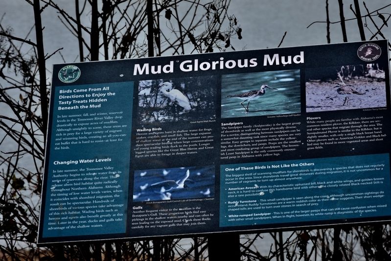
Mud Glorious Mud Marker
| 101 ► Alabama, Lauderdale County, Waterloo — Mud Glorious Mud — |
| On Lauderdale County 1 (County Route 1) 0.8 miles north of Lauderdale County 14 (County Route 14), on the left when traveling north. | |||
| 102 ► Alabama, Lauderdale County, Waterloo — Waterloo — Settled 1819~Incorporated 1832 — |
| 103 ► Alabama, Lawrence County, Town Creek — A Brief History — Wheeler Lock & Dam — |
| On Wheeler Dam Highway (Alabama Route 101) at County Route 412 on Wheeler Dam Highway. | |||
| 104 ► Alabama, Lawrence County, Town Creek — From Wheeler to the moon ... — Wheeler Lock & Dam — |
| On Wheeler Dam Highway (Alabama Route 101) at County Route 412 on Wheeler Dam Highway. | |||
| 105 ► Alabama, Lawrence County, Town Creek — The TVA System of Multi-purpose Dams — Wheeler Dam — Built for the people of the United States of America — |
| Near Wheeler Dam Rd (State Highway 101) north of County Road 150, on the right when traveling north. | |||
| 106 ► Alabama, Lee County, Auburn — Chewacla State Park — (CCC) — |
| On Murphy Drive, 0.2 miles east of Wrights Mill Road (County Road 33), on the right when traveling east. | |||
| 107 ► Alabama, Lee County, Auburn — Wright’s Mill — |
| On Murphy Drive at Wrights Mill Road (County Road 33), on the left when traveling east on Murphy Drive. | |||
| 108 ► Alabama, Lee County, Opelika — Bean's Mill — |
| On West Point Parkway (U.S. 29 at milepost 197), 0.6 miles south of County Road 390, on the right when traveling south. | |||
| 109 ► Alabama, Limestone County, Elkmont — Pettusville — |
| On Pettusville Road (County Road 55) 0.2 miles north of Dunnavant Road, on the left when traveling north. | |||
| 110 ► Alabama, Limestone County, Mooresville — Cottonport / Mooresville — |
| On Old Highway 20 at Mooresville Road on Old Highway 20. | |||
| 111 ► Alabama, Madison County, Huntsville — 1 — History at Its Source — Huntsville Water Trail — |
| Near Church Street Southwest south of Clinton Avenue West. | |||
| 112 ► Alabama, Madison County, Huntsville — 8 — Huntsville Utilites Special Awards — Huntsville Water Trail — |
| 113 ► Alabama, Madison County, Huntsville — Lowell M. Anderson — Father of Monte Sano Club — |
| On Georgetta Drive, 0.2 miles east of Monte Sano Blvd SE, on the right when traveling north. | |||
| 114 ► Alabama, Madison County, Huntsville — 2 — Making the Water Work — Huntsville Water Trail — |
| Near Fountain Circle Southwest near West Side Square. | |||
| 115 ► Alabama, Madison County, Huntsville — Northern Terminus Indian Creek Canal — First Canal in Alabama — Incorporated 1820, Completed 1831 — |
| Near Spragins Avenue Northwest east of Church Street Northwest. | |||
| 116 ► Alabama, Madison County, Huntsville — Norwegian Light Beacon And Fog Bell — |
| Near Williams Avenue Southwest west of Church Street Southwest. | |||
| 117 ► Alabama, Madison County, Huntsville — The Big Spring — |
| Near Spragins Street Southwest south of Spring Street Southwest. | |||
| 118 ► Alabama, Madison County, Huntsville — 4 — The Big Spring of Today — Huntsville Water Trail — |
| Near Fountain Circle Southwest near West Side Square. | |||
| 119 ► Alabama, Madison County, Huntsville — 3 — The Spring Runs Its Course — Huntsville Water Trail — |
| Near Fountain Circle Southwest near West Side Square. | |||
| 120 ► Alabama, Madison County, Huntsville — 6 — The Water's Journey to You — Huntsville Water Trail — |
| 121 ► Alabama, Madison County, Huntsville — TVA Coverage Area — |
| On Tranquility Base west of Old Madison Pike. | |||
| 122 ► Alabama, Madison County, Huntsville — 7 — Where Does the Spring Water Go? — #7 — Huntsville Water Trail — |
| Near Church Street Southwest south of Clinton Avenue West, on the left when traveling south. | |||
| 123 ► Alabama, Madison County, Triana — Triana, Alabama — |
| On 6th Street at Record Street, on the right when traveling east on 6th Street. | |||
| 124 ► Alabama, Marengo County, Demopolis — Whitfield Canal — |
| On South Walnut Avenue at West Morgan Street, on the left when traveling north on South Walnut Avenue. | |||
| 125 ► Alabama, Marshall County, Guntersville — History of Guntersville — |
| On Florida Short Route/Gunter Avenue (U.S. 431) at Lurleen B Wallace Drive, on the right when traveling south on Florida Short Route/Gunter Avenue. | |||
| 126 ► Alabama, Marshall County, Guntersville — Section of Core — |
| On Paddle Wheel Drive (U.S. 431) at Taylor Street, on the right when traveling south on Paddle Wheel Drive. | |||
| 127 ► Alabama, Mobile County, Bayou La Batre — Alabama's Coastal Connection — Blessing of the Fleet — |
| On South Wintzell Avenue (Alabama Route 188) south of Tapia Avenue, on the right when traveling south. | |||
| 128 ► Alabama, Mobile County, Bayou La Batre — Bayou La Batre — |
| On South Wintzell Avenue (Alabama Route 188) at Tapia Avenue, on the left when traveling south on South Wintzell Avenue. | |||
| 129 ► Alabama, Mobile County, Bayou La Batre — Bayou La Batre, Alabama — |
| On South Wintzell Avenue (Alabama Route 188) near Tapia Avenue, on the right when traveling south. | |||
| 130 ► Alabama, Mobile County, Dauphin Island — 19th Century Shipwreck — Exposed by Hurricane Georges — |
| Near Bienville Boulevard east of Albatross Street, on the right when traveling east. | |||
| 131 ► Alabama, Mobile County, Dauphin Island — British Occupation of Dauphin Island — February - April 1815 — |
| Near Bienville Boulevard east of Albatross Street, on the right when traveling east. | |||
| 132 ► Alabama, Mobile County, Dauphin Island — Energy from the Sands of Time — |
| On Bienville Boulevard, 0.1 miles east of Albatross Street, on the left when traveling east. | |||
| 133 ► Alabama, Mobile County, Grand Bay — Mark 8 Projectile — |
| Near Interstate 10, 1 mile Mississippi/Alabama State Line. | |||
| 134 ► Alabama, Mobile County, Grand Bay — William Bartram Trail — Traced 1773-1777 — Deep South Region — |
| Near Interstate 10, 2 miles east of Franklin Creek Road. | |||
| 135 ► Alabama, Mobile County, Mobile — "Take Her Down!" — Howard Walter Gilmore, Commander, U.S.N. — Born 29 September 1902, Selma, Ala. — |
| Near Battleship Parkway (U.S. 90). | |||
| 136 ► Alabama, Mobile County, Mobile — 26 - Foot Motor Surfboat — USCG-MK 5 — |
| Near Battleship Parkway at Old Spanish Trail (U.S. 98). | |||
| 137 ► Alabama, Mobile County, Mobile — 41-Foot Utility Boat — USCG-UTB — |
| Near Battleship Parkway at Old Spanish Trail (U.S. 98). | |||
| 138 ► Alabama, Mobile County, Mobile — 2 — Africatown — |
| On Bay Bridge Road (Alternate U.S. 90) at Magazine Road South, on the right when traveling east on Bay Bridge Road. | |||
| 139 ► Alabama, Mobile County, Mobile — Battle of Mobile Bay Memorial — |
| Near Virginia Street, 0.1 miles east of South Ann Street. | |||
| 140 ► Alabama, Mobile County, Mobile — Crew of CSS H. L. Hunley Memorial — |
| Near Virginia Street, 0.1 miles east of South Ann Street. | |||
| 141 ► Alabama, Mobile County, Mobile — CSS Alabama Memorial — |
| Near Virginia Street, 0.1 miles east of South Ann Street. | |||
| 142 ► Alabama, Mobile County, Mobile — Gen. William C. Gorgas — |
| On Saint Stephens Road (U.S. 45) at Rosemont Avenue, on the right when traveling south on Saint Stephens Road. | |||
| 143 ► Alabama, Mobile County, Mobile — H.L. Hunley — Confederate States Torpedo Boat Submarine — |
| Near Battleship Parkway at Old Spanish Trail (U.S. 98). | |||
| 144 ► Alabama, Mobile County, Mobile — Home of Raphael Semmes — |
| On Government Street (U.S. 90) at South Bayou Street, on the right when traveling west on Government Street. | |||
| 145 ► Alabama, Mobile County, Mobile — In Memory of the Battle of Mobile Bay — |
| Near Dauphin Street at St Emanuel Street. | |||
| 146 ► Alabama, Mobile County, Mobile — McGowin-Lyons — One St. Louis Centre — 1907-1986 — |
| On St Louis Street at North Water Street, on the right when traveling east on St Louis Street. | |||
| 147 ► Alabama, Mobile County, Mobile — Memorial to USS Herring (SS-233) — Submarines and the Battleship Park — |
| On Battleship Parkway (U.S. 90/98) east of Old Spanish Trail (U.S. 90/98). | |||
| 148 ► Alabama, Mobile County, Mobile — Mobile City Limits — 1711 — |
| On North Royal Street at St Michael Street, on the right when traveling north on North Royal Street. | |||
| 149 ► Alabama, Mobile County, Mobile — Mobile National Cemetery — |
| Near Virginia Street, 0.1 miles east of South Ann Street. | |||
| 150 ► Alabama, Mobile County, Mobile — 31 — Old Plateau Cemetery — Africatown Graveyard — |
| On Bay Bridge Cutoff Road, 0.1 miles north of Chin Street, on the left when traveling south. | |||
| 151 ► Alabama, Mobile County, Mobile — Old Slave Markets — |
| On St Louis Street at North Royal Street, on the right when traveling west on St Louis Street. | |||
| 152 ► Alabama, Mobile County, Mobile — Richards D.A.R. House Museum — 1860 — |
| On North Joachim Street, 0.1 miles south of Congress Street. | |||
| 153 ► Alabama, Mobile County, Mobile — The Fallen Guardians Monument — |
| On Battleship Parkway, on the right when traveling south. | |||
| 154 ► Alabama, Mobile County, Mobile — The Hunley — |
| On North Water Street, 0.1 miles north of St Anthony Street, on the right when traveling north. | |||
| 155 ► Alabama, Mobile County, Mobile — The Submarine Lookout Memorial — Submarines and the Battleship Park — |
| On Battleship Parkway. | |||
| 156 ► Alabama, Mobile County, Mobile — U.S. Coast Guard Monument — Mobile, Alabama — |
| On South Water Street. | |||
| 157 ► Alabama, Mobile County, Mobile — United States Ship Alabama (BB-60) — Battleship Memorial Park — |
| Near Battleship Parkway (U.S. 90) east of Dunlap Drive. | |||
| 158 ► Alabama, Mobile County, Mobile — USN Patrol Boat — PB MK3 — |
| Near Battleship Parkway at Old Spanish Trail (U.S. 89). | |||
| 159 ► Alabama, Mobile County, Mobile — 8 — Wallace Turnage — |
| On Conti Street at South Joachim Street, on the right when traveling west on Conti Street. | |||
| 160 ► Alabama, Mobile County, Plateau — Cudjoe “Kazoola” Lewis — c. 1840-1935 — |
| On Bay Bridge Road (Alternate U.S. 90) at Bay Bridge Cutoff Road, on the right when traveling west on Bay Bridge Road. | |||
| 161 ► Alabama, Monroe County, Burnt Corn — Burnt Corn Spring — |
| On Conecuh County Road 5 (County Road 5) at Burnt Corn Loop, on the right when traveling south on Conecuh County Road 5. | |||
| 162 ► Alabama, Monroe County, Goodway — Old Federal Road — |
| On Old Stage Road (County Road 5) 0.1 miles north of Hollinger Road, on the left when traveling north. | |||
| 163 ► Alabama, Montgomery County, Maxwell Air Force Base Gunter Annex — Award of Air Force Cross to Jon D. Harston — |
| Near McDonald Street at Avenue D. | |||
| 164 ► Alabama, Montgomery County, Montgomery — Alabama Bicentennial Park / Ancient Sea — |
| On North Bainbridge Street at Dexter Avenue, on the right when traveling south on North Bainbridge Street. | |||
| 165 ► Alabama, Montgomery County, Montgomery — Alabama River: The Grand Avenue — |
| Near Water Street west of Whitman Street, on the right when traveling west. | |||
| 166 ► Alabama, Montgomery County, Montgomery — Europeans Along the Alabama River — |
| Near Water Street. | |||
| 167 ► Alabama, Montgomery County, Montgomery — High Red Bluff — (Chunnanugga Chatty in Creek Indian Language) — |
| Near Riverfront Park at Water Street. | |||
| 168 ► Alabama, Montgomery County, Montgomery — Historic Sites Near Fairview Environmental Park — |
| Near West Fairview Avenue east of Interstate 65. | |||
| 169 ► Alabama, Montgomery County, Montgomery — Montgomery and Electricity / Hydroelectricity in the River Region — |
| On East Jefferson Street at North Lawrence Street, on the right when traveling east on East Jefferson Street. | |||
| 170 ► Alabama, Montgomery County, Montgomery — Naval Heroes of the War of 1812 — Dexter Avenue, Montgomery, Alabama — |
| On Dexter Avenue at South McDonough Street, on the right when traveling east on Dexter Avenue. | |||
| 171 ► Alabama, Montgomery County, Montgomery — Ray W. Scott Jr. Founded Bass Anglers Movement — |
| On Madison Avenue at North Bainbridge Street, on the right when traveling west on Madison Avenue. | |||
| 172 ► Alabama, Montgomery County, Montgomery — The Domestic Slave Trade / Slave Transportation to Montgomery — |
| On Commerce Street at Water Street, on the left when traveling north on Commerce Street. | |||
| 173 ► Alabama, Montgomery County, Montgomery — Transportation and Commerce — |
| On Water Street. | |||
| 174 ► Alabama, Morgan County, Decatur — Cherokee Trail Of Tears — |
| Near Oak Street north of Market Street. | |||
| 175 ► Alabama, Morgan County, Decatur — Gen. Jos. Wheeler — |
| On Bee Line Hwy (U.S. 31), on the left when traveling north. | |||
| 176 ► Alabama, Morgan County, Decatur — Ingalls Shipyard — |
| On Wilson Street (U.S. 20), on the right when traveling west. | |||
| 177 ► Alabama, Morgan County, Decatur — Packed with People — Rhodes Ferry Park — Trail of Tears National Historic Trail — |
| Near Oak Street north of Market Street when traveling north. | |||
| 178 ► Alabama, Morgan County, Decatur — Uprooted From Home — Rhodes Ferry Park — Trail of Tears National Historic Trail — |
| Near Oak Street north of Market Street. | |||
| 179 ► Alabama, Morgan County, Priceville — Town of Priceville — Crossroads of North Alabama — |
| Near Highway 67 South, 0.2 miles north of Willowbrook Street, on the right when traveling north. | |||
| 180 ► Alabama, Pickens County, Pickensville — History of the Snagboat Montgomery — |
| Near Lock and Dam Road, 0.5 miles south of Marina Parkway, on the right when traveling south. | |||
| 181 ► Alabama, Pickens County, Pickensville — The Tennessee - Tombigbee Waterway — |
| Near Lock and Dam Road, 0.5 miles south of Marina Parkway, on the right when traveling south. | |||
| 182 ► Alabama, Pickens County, Pickensville — The U.S. Snagboat Montgomery — A National Historic Landmark — |
| On Lock and Dam Road, 0.5 miles south of Marina Parkway, on the right when traveling south. | |||
| 183 ► Alabama, Russell County, Fort Mitchell — Fort Mitchell and Creek Removal — Creek Heritage Trail — |
| Near County Highway 165, 2.3 miles south of Nuckols Road (Road 39). | |||
| 184 ► Alabama, Russell County, Holy Trinity — Spanish Fort, 1689-1691 — |
| On Alabama Route 165 at Terminal Road (Route 54), on the right when traveling north on State Route 165. | |||
| 185 ► Alabama, Russell County, Phenix City — Ancient Fisheries — |
| Near 13th Street at 3rd Avenue, on the right when traveling east. | |||
| 186 ► Alabama, Russell County, Phenix City — The Creek Town of Coweta — Creek Heritage Trail — |
| Near Dillingham Street at Brickyard Road (Route 61). | |||
| 187 ► Alabama, Russell County, Phenix City — The Tie-Snake — |
| Near 13th Street south of 3rd Avenue, on the right when traveling east. | |||
| 188 ► Alabama, Shelby County, Helena — Central Iron Works — |
| On Lake Davidson Lane at Helena Road (Alabama Road 261), on the right when traveling east on Lake Davidson Lane. | |||
| 189 ► Alabama, St. Clair County, Cook Springs — Site of the Cook Springs Hotel — 1884-1954 — |
| On Cook Springs Road, 0.1 miles south of Interstate 20, on the right when traveling south. | |||
| 190 ► Alabama, St. Clair County, Cropwell — Andrew Jackson — |
| On Mays Drive at Hardwick Road, on the right when traveling north on Mays Drive. | |||
| 191 ► Alabama, St. Clair County, Cropwell — Coosa River — |
| On Hardwick Road at Mays Drive, on the left when traveling north on Hardwick Road. | |||
| 192 ► Alabama, Sumter County, Livingston — Sumter County's Covered Bridge — |
| On Student Union Drive, 0.5 miles south of University Drive, on the right when traveling south. | |||
| 193 ► Alabama, Talladega County, Lincoln — Lincoln, Alabama — |
| On County Road 433 north of 1st Avenue, on the right when traveling north. | |||
| 194 ► Alabama, Talladega County, Talladega — USS Talladega (APA-208) — Talladega County — “The Tremblin’ T” — |
| On W. North Street at Court Square West, on the left when traveling west on W. North Street. | |||
| 195 ► Alabama, Tallapoosa County, Daviston — Who Were the Creek? — Horseshoe Bend National Military Park — |
| Near Horseshoe Bend Road (Alabama Route 49) 2.1 miles north of Freeman Road, on the left when traveling north. | |||
| 196 ► Alabama, Tuscaloosa County, Tuscaloosa — 1887: The Beginnings of Modern Tuscaloosa — City of Tuscaloosa — |
| Near 21st Avenue south of 6th Street, on the right when traveling south. | |||
| 197 ► Alabama, Tuscaloosa County, Tuscaloosa — Burns’ Shoals — |
| Near Greensboro Avenue north of 2nd Street (Jack Warner Parkway). | |||
| 198 ► Alabama, Tuscaloosa County, Tuscaloosa — Evolution of the Black Warrior-Tombigbee Waterway — |
| On 21st Avenue, 0.1 miles north of Jack Warner Parkway, on the right when traveling north. | |||
| 199 ► Alabama, Tuscaloosa County, Tuscaloosa — Gabriel Moore — Governor 1829 - 1831 — |
| On 6th Street west of 28th Avenue, on the right. | |||
| 200 ► Alabama, Tuscaloosa County, Tuscaloosa — Gorgas House — |
| On Capstone Drive at Colonial Drive, on the right when traveling west on Capstone Drive. | |||
14690 entries matched your criteria. Entries 101 through 200 are listed above. ⊲ Previous 100 — Next 100 ⊳