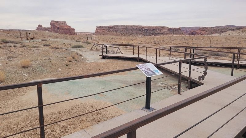
The dinosaurs and other animals here walked on a mat of algae that formed in a shallow lake. The animals left tracks after the lake water receded, but before the mat dried up. The mat was then buried by layers of sand and mud. The buried mat . . . — — Map (db m271487) HM
The odd-shaped trace before you may be an impression made by a crocodile sliding on its belly into shallow water, leaving at least one footprint, and possibly belly and tail slide marks behind. Such traces are also found just south of Moab in the . . . — — Map (db m271485) HM
The tracks in front of you are the first dromaeosaur tracks that have been found in North America! This short trackway was made by a dromaeosaurid theropod, probably a large Deinonychus. Notice that there are only two toes preserved in each track; . . . — — Map (db m271486) HM
You are currently standing on the Cedar Mountain Formation, which consists of sandstones and mudstones. It is split into three members (or subsections) in this region: Yellow Cat, Poison Strip, and Ruby Ranch. The rocks at the Mill Canyon Dinosaur . . . — — Map (db m271493) HM
The large, well-preserved tracks in front of you are the beginning of a 17-step track-way of a very large, carnivorous dinosaur. Tracks of a similar dinosaur have also been found in central Texas. The tracks here are about 16-20 inches long and are . . . — — Map (db m271547) HM
The trackway in front of you is that of a medium-sized carnivorous dinosaur. Similar tracks have also been found in Wyoming. The tracks here are about 7-14 inches long and are from a dinosaur that was about 6 feet tall at the hip. We do not know . . . — — Map (db m271548) HM
The ornithopod tracks in front of you are likely attributed to a dinosaur similar to Iguanodon. These herbivorous dinosaurs often walked on two feet, but had the ability to use their front feet for walking, as well. The tracks in this series have a . . . — — Map (db m271490) HM
The Poison Spider Dinosaur Tracksite preserves the tracks of small to large theropod (meat-eating) dinosaurs. These unique tracks provide a glimpse into the past. Tracks help paleontologists understand the approximate size of the animal, the speed . . . — — Map (db m271555) HM
Tracks of theropod dinosaurs are relatively common in the Early Jurassic rocks of the Navajo Sandstone and occur in several places around the Moab area. The tracks from this site represent up to 10 different individual animals. The rocks containing . . . — — Map (db m271569) HM
Sauropods, or long-necked, plant-eating dinosaurs, are also known from this site. These four-legged herbivores had front footprints that are slightly smaller than those of their back feet. The front feet leave behind lima bean-shaped tracks that are . . . — — Map (db m271488) HM
The impressions in front of you represent the trackway of a four-legged or quadrupedal dinosaur that is walking away from you toward the hillside. These particular tracks belong to a relatively small dinosaur about 11 feet long - leaving behind a . . . — — Map (db m271492) HM
The tracks you can see along this short trail, and from the parking lot, were made by three-toed meat-eating dinosaurs. These tracks were formed along the edge of a lake that would have been found between dunes, in a vast sand dune sea, known as an . . . — — Map (db m271565) HM
This large track slab was first documented in 1965. The block had fallen from the hillside directly in front of you and tilted outward, reveling these dinosaur tracks that had been hidden from view for 190 million years. Most of the tracks preserved . . . — — Map (db m271570) HM
In 1937, Daniel Thomas was digging a trench in this yard, at this location to connect into Orem City's new municipal water system. He uncovered what appeared to be a large ancient tooth. Further excavation by a team of archaeologists sent by the . . . — — Map (db m301642) HM
In 1849 an 11,000 year old Beluga Whale was found north of this site in what had been the Champlain Sea. Resident J.G. Thorp collected the bones, and naturalist Zadock Thompson assembled the skeleton now displayed in the Perkins Museum of Geology . . . — — Map (db m75963) HM
During construction of what became the Rutland Railroad, two important events occurred in Mount Holly. In 1848, a construction crew discovered the tusk and tooth of a woolly mammoth in the nearby wetland. These are on display in the Community . . . — — Map (db m104493) HM
Welcome to the Mid-Lothian Mines Park
The Mid-Lothian Mines Park is in the heart of Midlothian’s coal mining past and is encompassed by the Richmond Coal Basin. Mining in the Midlothian area of the Basin represents the first attempt at . . . — — Map (db m294405) HM
The Anhinga (Anhinga anhinga), sometimes called Snakebird, Darter, American Darter, or Water Turkey, is a water bird of the warmer parts of the Americas. The word “anhinga” comes from the Brazilian Tupi language and means devil bird or snake bird. — — Map (db m285735) HM
Triceratops was one of the last living dinosaurs.
They were between 23 to 28 feet long and weighed between 6 and 13 tons! Their habitat was mainly on the Eastern side of the ancient Rocky Mountain range.
Predators usually have eyes that face . . . — — Map (db m285723) HM
Approximately 17 million years ago, during the Miocene Epoch, these 150-foot-high cliffs along the Potomac River formed the ancient seashore. Rich Miocene fossil deposits, which exist in the 1 1/2 -mile-long series of Horsehead, Stratford and Nomini . . . — — Map (db m34585) HM
This landscape was built by ancient lava flows and sculpted by powerful Ice Age floods. Clues to this fascinating past are all around you.
Remains of a Fossil Forest
The park contains hundreds of pieces of petrified wood that were . . . — — Map (db m82824) HM
New River coal, the natural resource that created the gorge's boom and bust economy, is the product of a geologic process millions of years in the making.
300 million years ago, the landscape here was a tropical swamp covered with vegetation. . . . — — Map (db m242423) HM
In this cave, whose beautiful natural formations have long been known, salt petre was manufactured before 1835. When war broke out between the states in 1861, it was a source of powder supply for General Lee's army. — — Map (db m76509) HM
Over 300 milion years ago during the Carboniferous Period, the landscape of what is now West Virginia looked much different. During the Pennsylvanian sub-period (323.2-298.9) million years ago), vast forests of strange looking plants surrounded . . . — — Map (db m238305) HM
Fossilized tree stumps found in the rock above coal seams are referred to as "kettle bottoms". When the coal is removed, kettle bottoms, similar to this one fall out into the mine entry. This fossil is approximately 300 million years old of the . . . — — Map (db m228184) HM
Lycopods are prehistoric plants of this forest. Their origin reveals the rich history of the land.
Discover landscapes of the past. Imagine forests of the future.
Paleozoic Era
Silurian
Lycopods Take Root on Land . . . — — Map (db m238655) HM
Millions of years ago, Wisconsin was covered by a vast, shallow inland sea, teeming with marine life. Over time, the shells of animals such as gastropods and corals became fossilized in limestone deposits. Twelve thousand years ago during the last . . . — — Map (db m119310) HM
Roy Chapman Andrews, one of the most celebrated explorers of the 20th century, was born in Beloit on January 26, 1884. He grew up across the river at 419 St. Lawrence Avenue. Andrews acquired a lifelong passion for the natural world during his . . . — — Map (db m86686) HM
To the north lies Como Bluff - "The Dinosaur Graveyard" - one of the greatest and well known fossil beds of dinosaur remains in the world. There paleontologist of the 19th century discovered and unearthed many excellent fossil specimens of the . . . — — Map (db m89665) HM
Soon after the retreat of the great Western Interior Seaway of. the Cretaceous Period, great coal swamps covered Eastern Wyoming. This fossilized tree stump was recovered from the Eagle Butte Coal Mine located about 48 miles to the North of here. . . . — — Map (db m203255) HM
Also known as "Temple of the Sioux," Sundance Mountain rises majestically in the southwest. It belongs to the Bear Lodge Mountain Range, which defines the northwestern edge of the Black Hills. It was named for the Plains Indians' religious . . . — — Map (db m45541) HM
Giant cypress trees growing today in swamps (or forested wetlands), such as these found in Louisiana's Pointe Lake, used to grow in Wyoming back when it was a warm, subtropical swamp - about 55 million years ago during the Late Paleocene epoch. Some . . . — — Map (db m45539) HM
Located a short distance to the east and camouflaged by the red eroded landscape is the Vore Buffalo Jump. This sinkhole served early residents as a slaughterhouse. using the natural pit as a trap, hunters would capture bison in late fall by running . . . — — Map (db m45537) HM
The red cliffs seen in and around the park are called the Red Peak Formation - part of the Chugwater Group. This rock outcrop is composed of fine-grained sandstone and is up to 600 feet thick. The brick red color is caused by oxidation of iron . . . — — Map (db m97658) HM
Fossil Butte is a 50 million year old lakebed and one of the richest fossil resources in the world. It is part of the Green River Formation, a layer of rock composed of laminated limestone, mudstone, and volcanic ash. Complete paleo-ecosystems are . . . — — Map (db m36624) HM
Almost all we know of life in Fossil Lake came from quarries on Cundick Ridge, Fossil Butte, Fossil Ridge, and nearby sites.
Commercial fossil fish mining began in the last decades of the 19th century. Some specimens were sold as souvenirs, and . . . — — Map (db m270073) HM
During construction of Highway 191 in the early 1990s, the oldest known pronghorn kill processing site in Wyoming was discovered and excavated on the ridges below. Three intact cultural layers were uncovered with radiocarbon dates ranging from 4690 . . . — — Map (db m180303) HM
The bed of prehistoric Lake Gosiute (Go-shute) lies hundred of feet below you. This ancient lake set the stage of the world's largest trona and oil shale deposits as well as a significant natural gas reserve.
Lake Gosiute Creates Trona . . . — — Map (db m90093) HM
Ages ago, these mountains were deep within the Earth’s crust, and the area that is known today as the Bighorn Mountains was a basic. Beginning about 75 million years ago the land began to slowly rise above the sea bed reaching an elevation of nearly . . . — — Map (db m97887) HM
Extinct species of mammoths, horses, camels, and bison roamed this area 11,000 years ago and were being killed by humans known as the Clovis hunters. South of this spot 400 meters is the location of one of the largest known Clovis mammoth kills . . . — — Map (db m97862) HM
This relic of an ancient River Red Gum tree was discovered in 1988 during the first archaeological dig at this precinct when the foundations of an early house were being investigated. It is possibly the only tangible reminder of the woodland that . . . — — Map (db m302150) HM
[English] In 1901, Mount Stephen Reserve was enlarged and became Yoho Park Reserve. The following year, Mount Stephen House was also expanded and now featured a rotunda, a huge dining room, a theatre and 60 rooms. Word got out . . . — — Map (db m203581) HM
In the summer of 2000, two young boys tubing down Flatbed Creek stumbled upon ankylosaur tracks - the longest dinosaur trackway in British Columbia at the time. This discovery was a turning point in the development of Tumbler Ridge and the Peace . . . — — Map (db m187874) HM
This is the site of an ancient lake, where 53 million-year-old fossil beds hold secrets of life in a warmer time. Preserved plants, insects and fish tell a story of early life in BC. At McAbee, climate and geology have created a treasure trove of . . . — — Map (db m187879) HM
English:
Some of the world's oldest fossils from a time long before dinosaurs have been found near here. Billion-year-old cyanobacteria lived underwater in Precambrian times and left circular shapes in the rock called . . . — — Map (db m147794) HM
English:
Saint John was home to some of Canada's earliest fossil hunters. One great story from the 1880s tells how a young boy named Will Matthew found a gigantic trilobite — perhaps the largest ever found at that time about a . . . — — Map (db m147799) HM
These are critically endangered microbial structures. Thrombolites-building micro-organisms resemble the earliest form of life on Earth. These organisms were the only known form of life from 3.5 billion to 650 million years ago. These are some of . . . — — Map (db m79656) HM
English:
In 2000, the global stratotype for the boundary between the Cambrian and Ordovician systems was designated here at Green Point by the International Commission of Stratigraphy. It is located within a bed of shale and . . . — — Map (db m79654) HM
Milton Outlier - Halton's Legendary Promontory
You are standing atop of the largest detached section of the Niagara
Escarpment in Ontario. Known as the Milton Outlier, this 6 square
km island of bedrock was separated from the main . . . — — Map (db m285251) HM
After the ice melted away from southern Ontario, Paleo-Indians moved into the
region. Southern Ontario was a treeless tundra then, like today's Arctic.
The Paleo-Indians travelled widely, hunting caribou with spear points made of chert, a type . . . — — Map (db m241978) HM
English:
DNA from fossil bones reveals that the woolly mammoth (Mammuthus primigenius) evolved around 350,000 years ago in North America. The life-sized replicas seen here were created by Canadian Museum of Nature sculptors . . . — — Map (db m144900) HM
Peterborough serves as the gateway to the Kawarthas. These lakes were
shaped by two major land forms and later by glacial scouring. The Canadian
Shield to the north represents some of the oldest rock in the world (3 billion
years). It forms a . . . — — Map (db m315219) HM
The first Director of the Royal Ontario Museum of Palaeontology, Parks was born in Hamilton and educated at the University of Toronto, from which he received a Doctorate in 1900. Initially known as an expert on "stromatoporoids", a unique group of . . . — — Map (db m83663) HM
The Mural, one of the largest in the world,
represents the life of the first inhabitants of the
Cuban archipelago. During the early days of 1959,
Dr. Antonio Núñez Jimenez told Fidel Castro
about his visits to these mountains where had
been . . . — — Map (db m219863) HM
Toxodonte o Hipopotamo americano Mixotoxodon larensis Se originaron en Sur America y logran llegar hasta el sur de Mexico cuando se consolida el puente centroamericano, que origino el gran intercambio biótico centroamericano, hace unos tres . . . — — Map (db m93000) HM
Perezoso Gigante Eremotherium laurillardi Este mamifero se extinguio hace unos 10 mil años por causas que aun se desconocen, pero se cree que tuvo mucho que ver el cambio climático que produjo la ultima glaciación. Se originaron en Sur America y . . . — — Map (db m93014) HM
Suíomh Geopháirc Aillte an Mhothair Cliffs of Moher Geopark Site [Gaeilge:] Imeall an Atlantaigh: Tá Aillte an Mhothair níos mó ná 200 méadar ar airde agus níos mó ná 3,000 ciliméadar ón gcéad talamh eile, i dTalamh an Éisc, . . . — — Map (db m300883) HM
Museo Nacional de Antropologia. Tiene sus inicios en 1825 cuando el Presidente Guadalupe Victoria crea el Museo Nacional de Historia coleccionando objetos arquelogicos y documentos prehispánicos. Sufriendo posteriormente cambios . . . — — Map (db m103496) HM
Isla Momotombito: Estratovolcán de 350 msnm. cono apagado de basalto. La isla fue llamado por los indígenas "Cocobolo", por la abundancia de ñámbares fue un santuario arqueológico precolumbino. La composición de flora: Bosque latifoliado bajo . . . — — Map (db m93654) HM
Water, sculptor of landscapes
5.5 million years ago, this region was completely covered by rock (1). Little by
little, rainwater carved a path between fractures in the conglomerate, eroding
and sculpting the Mountain of Montserrat and . . . — — Map (db m244339) HM
The University of Manchester commemorates Marie Stopes 1880–1958 Palaeobotanist and Pioneer of Family Planning Lecturer in Palaeobotany 1904–1907 — — Map (db m315444) HM
The Beyer Building The building in front of you is named after Charles Beyer (1813–1876), an accomplished railway engineer who co-founded Beyer, Peacock and Company, a locomotives manufacturer in Gorton. A weaver’s son from Saxony, Beyer moved . . . — — Map (db m315453) HM
Richard Owen was born on 20 July 1804 in the house that stood on this site. He became a leading authority on natural history, invented the word 'dinosaur' and published over 600 books and papers. He was a firm favourite of Queen Victoria and Prince . . . — — Map (db m280002) HM
This is the world-famous type locality for the Ludlow Bone Bed in which the fragmented remains of primitive fish are abundant. It marks the beginning of a change in this region about 400 million years ago from open seas to extensive land areas . . . — — Map (db m266959) HM
465 entries matched your criteria. Entries 401 through 465 are listed above. ⊲ Previous 100