On U.S. 27 at West Water Street, on the right when traveling north on U.S. 27.
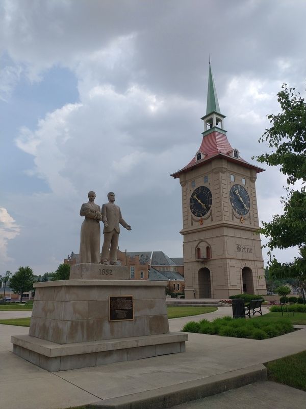
This monument is dedicated to the early settlers of Berne, Indiana, eighty-two devout Mennonite immigrants who came from the Bernese Jura of Switzerland. The first generations cleared the land and drained the swamps, building a future for those of . . . — — Map (db m227612) HM
On North County Line Road East (County Road 72) east of County Road 29, on the right when traveling east.
In 2012, God laid a vision on the hearts of the County Line leadership to continue restoring our communities with Christ by expanding the facilities on this site.
The project would cost $5 million, far beyond anything the church had ever done. . . . — — Map (db m211298) HM
On Wayne Street east of Barr Street, on the right when traveling east.
Methodism in Fort Wayne
area originated with the
establishment of a mission
in 1828.
Changed to Berry Street
Chapel in 1840.
Divided into First and
Wayne Street Churches
in 1849.
Reunited in 1968. — — Map (db m197284) HM
Near Parnell Avenue, 0.1 miles east of Spy Run Avenue Extension, on the left.
Johnny Appleseed legendary planter of orchards across Ohio, Indiana, and Illinois, was a real person named John Chapman. He was a friend to all God's creatures and a missionary for the Swedenborgian religion, a Christian denomination.
He was . . . — — Map (db m21560) HM
On South Barr Street at East Lewis Street, on the left when traveling north on South Barr Street.
Organized by Rev. Jesse Hoover on October 14, 1837, with a congregation of 24 families, it was the first Lutheran church in the Fort Wayne area. A school was organized by Rev. Hoover the same year. Originally known as the First Evangelical Lutheran . . . — — Map (db m162795) HM
On South Barr Street south of East Washington Street, on the right when traveling south.
This YMCA logo, established in the late 1800's combined the YMCA's Christian emphasis
with an equilateral triangle which stood for man's essential spirit, mind and body.
John 17:21 That all of them may be one, Father, just . . . — — Map (db m197197) HM
On Clinton Street, on the right when traveling north.
Oldest church structure in continuous use in Fort Wayne area and seat of Catholicism in northern Indiana.
Christianity carried to this part of the New World in 1600's by Catholic missionaries. Land formerly part of burial ground for Miami . . . — — Map (db m45024) HM
On West Wayne Street just east of Ewing Street, on the left when traveling east.
The first Presbyterian minister to conduct services at Fort Wayne was the Rev. Matthew Wallace, an Ohio pastor who served as chaplain to the army under General William Henry Harrison during the War of 1812 and accompanied the troops in the relief . . . — — Map (db m197192) HM
On Ewing Street, on the right when traveling north.
“Well done, good and faithful servant.”
(Ft. Wayne Chamber of Commerce – Jan. 7, 2927)
J.B. Franke dedicated his lift to service of others. He donated 80 acres to the City of Fort Wayne, which is now known as Franke park. Mr. . . . — — Map (db m119974) HM
On S. Calhoun Street, on the right when traveling north.
St. Mother Theodore Guerin founded the first
catholic school in Fort Wayne on this site
in 1846. Her community, The Sisters of
Providence, taught young people of
Fort Wayne for over 125 years. She was canonized
a Saint October 15, 2006
. . . — — Map (db m197229) HM
On West Washington Boulevard at Fairfield Avenue, on the right when traveling east on West Washington Boulevard.
The Roman Catholic Parish of St. Paul was established at this site in 1864 for German-speaking Catholics of the then northwestern part of Fort Wayne.
Over the course of 138 years, this property also served the needs of St. Paul . . . — — Map (db m197185) HM
On West Wayne Street just west of Ewing Street, on the right when traveling east.
Henry Rudisill, whose efforts had resulted in the establishment of Fort Wayne's first German Lutheran congregation in 1837, also initiated the founding of the community's first English-speaking Lutheran parish, the English Lutheran Church of the . . . — — Map (db m197187) HM
On West Berry Street at Fulton Street, on the left when traveling west on West Berry Street.
The Protestant Episcopal Assembly met May 26, 1839 with 17 charter members in Fort Wayne's courthouse. They built First Trinity Episcopal Church in 1847 on the northwest corner, Berry and Harrison Streets. Present Trinity Church built 1865, . . . — — Map (db m197191) HM
On Middle Rd at Grissom Ave, on the left when traveling north on Middle Rd.
(Front Side)
Construction begun summer 1942 under Captain Stratton O. Hammon, who used broad authority over laborers, suppliers, and railroad; base in use February 1943. More than 1,000 workers employed during construction. Base was over . . . — — Map (db m63819) HM
On Reed St at 9th St, on the right on Reed St. Reported missing.
Congregation was formed in 1879; reorganization in 1882 by the Reverend John R. Miller and a core of determined members. The present building, formerly a theater, was acquired in 1913. This African-American church, like many others, has served its . . . — — Map (db m63815) HM
On North High Street at West Franklin Street, on the right when traveling north on North High Street.
Placed on the National Register of Historic Places June 13, 1986, by the United States Department of the Interior in cooperation with the Indiana Department of Natural Resources, Division of Historic Preservation. — — Map (db m222241) HM
Near West North Washington Street at North Charles Street, on the right when traveling east.
A New Spiritual Anchor at Canal Park
During the 1830s and 40s the Canal
transformed this region into a new cultural
and economic entity. This new era propelled
a now confident Delphi into the mid and late
19th century. It was now ready . . . — — Map (db m163314) HM
On Wall Street at East Chestnut Street, on the right when traveling north on Wall Street.
The first Methodist sermon was preached in Indiana in 1802. A Methodist circuit rider first preached in Jeffersonville in 1803.
Our congregation grew out of that circuit, which was served by Peter Cartwright in 1804. There was no regular meeting . . . — — Map (db m206949) HM
On 5th Street west of Market Street, on the left when traveling west.
Oldest church building in Aurora
Built in 1848
First Evangelical United Church of Christ
(First German Evangelical Protestant Church)
Founded 1874
has been placed on the
National Register of Historic Places
by the . . . — — Map (db m201091) HM
On 4th Street east of Main Street, on the right when traveling east.
First Presbyterian Church
of Aurora
1844
has been placed on the
National Register
of Historic Places
by the United States
Department of the Interior — — Map (db m201098) HM
On 3rd Street west of Main Street, on the right when traveling west.
Founded 1816 as Methodist Episcopal church
Present building constructed 1853
National Register of Historic Places 1994
Plaque in memory of Kenneth Pitts — — Map (db m222252) HM
On State Road 1 just south of Sawmill Road, on the left when traveling north.
Second Oldest Roman Catholic Church in Indiana. Established 1824. Original log meeting house replaced by frame church in 1842. First brick edifice erected 1847. Present church dedicated October 19, 1879. — — Map (db m86237) HM
On State Road 1, 0.1 miles south of E. Fork Road, on the left when traveling north.
Erected 1821 by early settlers as a Methodist Church on land donated by John Ewbank. Services were held continuously for more than 125 years. Maintained by endowment fund. — — Map (db m86236) HM
On West High Street at Vine Street, on the right when traveling east on West High Street.
The Hamline Chapel United Methodist Church was organized in 1806. In 1847, the members of the congregation and Lawrenceburg citizens donated funds to construct this Classic Revival style chapel. The brick sanctuary and wooden steeple serve as a . . . — — Map (db m222802) HM
On East Center Street north of Walnut Street, on the left when traveling north.
The Regular Baptist Church of Lawrenceburg was the city's first Baptist congregation. The congregation organized in 1807 and met in various locations around the area. In 1846, this church was built in the Gothic Revival style. The building was . . . — — Map (db m187438) HM
On West Center Street east of Lake Street, on the left when traveling east.
This Greek Revival style church
was built in 1860 to replace the
congregation's original church, located
on East Center Street near the
marketplace. In the 1930's the
Fraternal Order of Eagles purchased
the building and occupied it for
many . . . — — Map (db m222847) HM
On West Center Street east of Lake Street, on the left when traveling east.
1830's – Ger. immigrants began setting in Lawrenceburgh.
1839 – Congregation formed. Like many other early church groups they met in the old Methodist Episcopal Meeting House erected in 1821 on Walnut Street where the Liedertafel Hall now . . . — — Map (db m222851) HM
On West Main Street at College Street, on the left when traveling west on West Main Street.
On this ground stood
Moores Hill College
Founded January 10, 1854
Administration of the college was vested in a board of trustees appointed by the Conference of the Methodist Church. Following the destruction of Moore Hall in 1915, the . . . — — Map (db m222230) HM
On County Road 7, 0.3 miles north of State Route 8, on the right when traveling north.
Who settled here in Keyser Township,
DeKalb County, state of Indiana in the year 1864
with purchase of three hundred seventy acres
of virgin land and from which in 1882
they donated the tract on which the nearby
Christian Union Church is . . . — — Map (db m159852) HM
On West County Road 700 South at South County Road 600 West when traveling west on West County Road 700 South.
This building was originally called
Richwoods Church for the dense growth
of black walnut and other valuable
timber in the area. The founding
pastor was Rev. Samuel Sayford, who
with his wife Mary, moved from Virginia
and ministered on . . . — — Map (db m231348) HM
On East Highland Avenue at North Wolfe Street, on the right when traveling east on East Highland Avenue.
Structure, circa 1893, is Muncie's oldest standing public school building. Purchased by church congregation, circa 1928. Rallying point in August 1930 when bodies of two African-American men, lynched in Marion, were brought to Muncie for embalmment . . . — — Map (db m31346) HM
Near West Minnestrista Boulevard south of North Minnetrista Parkway, on the left when traveling south.
This boulder marks the traditional
site of Wah-Pe-Kah-Me-Kunk
the White River Town of the Muncee Clan of Delaware Indians.
It is, also, a memorial to Joshua, a Christian Indian, who was burned by the tribe, March 1806, a martyr to his . . . — — Map (db m141131) HM
On Prairie Street at Chapman Avenue, on the right when traveling north on Prairie Street.
Elkhart became a major center for the Mennonite church after John and Salome Funk moved here from Chicago in 1867. He was founding pastor of Prairie Street Mennonite Church at this location in 1871. His Mennonite Publishing Company connected . . . — — Map (db m236149) HM
Near S. Main Street (State Road 15) 0.2 miles south of E. Kercher Road.
(Side One)
A History of the Winona
In the early 1900's, Indiana had more miles of electric train lines than any other state in the United States. The lines blossomed primarily at Indianapolis, radiating out to transport people . . . — — Map (db m70504) HM
Near County Road 32 at County Road 15, on the right when traveling west.
St. John's
Lutheran Church
Built 1852
Has been placed on the
National Register
of Historic Places
By the United States
Department of the Interior — — Map (db m74199) HM
Near N. Arnott Street (County Road 3) at W. Market Street (U.S. 6), on the right when traveling north.
Amish pioneer Christian Stahly purchased this 80 acre farm for his son Moses in 1873. The year before the village of Nappanee was established on the new northern route of the B&O Railroad. Three generations of related Amish families have lived here. . . . — — Map (db m74075) HM
On East 5th Street at North Eastern Avenue (Indiana Route 1), on the right when traveling east on East 5th Street.
1669 ~ Early "Indian Trail" Connecting Cincinnati to Northern Trading Posts
1812 ~ First Blockhouse
1813 ~ First Public Square
1828 ~ Parker, then Fayette County Seminary
1858 ~ First Public School
1874 ~ First High School Added
1904 ~ . . . — — Map (db m152029) HM
On East Oak Street at East 13th Street, on the right when traveling east on East Oak Street.
Born in New Albany 1892. Was ordained 1917 after graduation from St. Meinrad College and Seminary and assigned to his first parish in Indianapolis. He advanced in the church, becoming Bishop of Indianapolis 1934 and first Archbishop of new . . . — — Map (db m209410) HM
On East Market Street at East 7th Street, on the right when traveling west on East Market Street.
On this site a small frame building served as the first Catholic church in New Albany – Holy Trinity – founded in 1836 by Rev. Louis F. Neyron under Bishop Brute. In 1852 a large brick church was erected on the southeast corner of Market Street – . . . — — Map (db m207012) HM
Near East Main Street (Indiana Route 111) at State Street, on the right when traveling east.
As early as 1808, the area we know as New Albany was considered a good location for a settlement near the Ohio River and The Falls of The Ohio. The original 826 ½ acre tract of land — part of Clark’s grant — was between the Grant line and the foot . . . — — Map (db m194347) HM
Near East 3rd Street south of East Main Street (Indiana Road 111), on the left when traveling south.
The roof of this gazebo was built in 1915 to replace the spire from the bell tower of the
church after it was destroyed by lightning. After 101 years, it was removed to be replaced
with a replica of the original spire. Its intact removal by the . . . — — Map (db m207041) HM
On East Main Street (State Road 111) at East 3rd Street, on the right when traveling east on East Main Street.
This church was built by the 2nd Presbyterian congregation and in 1889 sold to the 2nd Baptist Church. It is one of the outstanding church buildings in Indiana. The clock was a landmark for river pilots. The organ, a museum piece, was built in . . . — — Map (db m207038) HM
On East Bonebrake Road near U.S. 41, on the left when traveling east.
Church: Established by United Brothers in 1828.
Building erected 1847 - Used until 1900.
Cemetery 1837 to present time.
The last resting place of pioneers and soldiers who served our country in seven wars. — — Map (db m3403) HM
Near East Lutheran Church Road west of South Grimes Road.
Organized in 1832 by German speaking families of the Evangelical Lutheran Church of Rowen County, North Carolina. Migrating to Indiana in 1828. August 7, 1836 Jacob and Elizabeth Linebaugh Bowman deeded land for the First Church and Cemetery. — — Map (db m10027) HM
On U.S. 52 at Little Cedar Road, on the right when traveling west on U.S. 52.
Built in 1812, this is the oldest church building still on its original location in the state. Interior shows rifle openings in walls, a balcony and raised pulpit. Burial plot adjoins church. — — Map (db m44920) HM
On East 10th Street at John Street, on the right when traveling east on East 10th Street.
First permanent Church in Brookville
was built by Methodists 1820.
It was occupied by
Methodists 1821 - 1839
Presbyterians 1839 - 1855
Lutherans 1855 - 1922
Baptists since 1953
Many Brookville early . . . — — Map (db m44699) HM
On Franklin Church Road, 0.3 miles south of Fairfield Causeway Road, on the right when traveling south.
United Brethren among earliest settlers in eastern Indiana during territorial period. Original structure, built 1831, one of first United Brethren churches in Indiana. Evangelical United Brethren Church joined Methodist Church to become United . . . — — Map (db m66867) HM
Organized July 18, 1841. The oldest Christian Congregation in Franklin Co. This Church was organized as a result of a revival meeting held by Rev. Alexander Campbell, founder of the Campbellites. Services were held for a time in the upper story of . . . — — Map (db m2404) HM
On Wynn Street at Holland Alley, on the right when traveling east on Wynn Street.
Circuit Riders helped, form this early congregation, first meeting at the Wm. Gordon Farm in the 1820's. A revival held in Kennedy's Wagon Shop in 1840 led to the building of a church in Metamora Cemetery called "Watcoot" the present church was . . . — — Map (db m227918) HM
On Pearl Street north of Vine Street, on the right when traveling north.
Located due north is the 1st of 4 chapels used in the procession. This annual devotion honors the Blessed Sacrament (Corpus Christi) on the 9th Sunday after Easter. It was first celebrated here in 1846, but originated in 13th century Germany. This . . . — — Map (db m66854) HM
On Main Street at Pearl Street, on the right when traveling east on Main Street.
Born in Battenheim, Alsace, April 23, 1813 "Founder of Village of Spires" Appointed Pastor 1844 Built Stone Church 1845 - Present Church 1862 Founded Convent of Sisters of St. Francis 1851 Served as Civic Leader and Missionary in Area Buried June . . . — — Map (db m66856) HM
On Main Street east of Pearl Street, on the left when traveling east.
Motherhouse of the Sisters of the Third Order of Saint Francis. Founded in 1851 by Mother Theresa Hackelmeier of Vienna, Austria. Rebuilt after fire in 1857. Chapel built in 1889. Convent reconstructed in 1876 and 1901. Novitiate built in 1931 and . . . — — Map (db m66851) HM
On Pearl Street south of Main Street, on the left when traveling south.
Father Franz Joseph Rudolf laid corner stone September 8, 1846. Succeeded original log church of St. Mary in 1848. Consecrated April 14, 1850. Replaced by present Holy Family Church in 1862. Made into part of Franciscan Friary in 1866. Renovated . . . — — Map (db m66853) HM
On U.S. 31 south of County Road W 375 N, on the right when traveling south.
Rev. Benjamin Marie Petit, of the City of Rennes, France, arrived as the Catholic missionary to the Potawatomi Indians in northern Indiana in November 1837. By June 1838, he had learned much of their difficult language and their culture, and had . . . — — Map (db m35500) HM
On County Road 600 N, 1.1 miles west of State Road 15.
The largest Indian cemetery in Indiana. Few graves are marked. The Indians buried here are largely descendants of Chief Metocinya and include Meshingomesia and his family. The first burial was probably in 1873. Burial was contrary to Indian . . . — — Map (db m182607) HM
On South Washington Street at East 35th Street, on the right when traveling south on South Washington Street.
As Black residents left nearby Weaver Settlement for jobs in Marion, Rev. G. W. Shelton began organizing a church on the southside of the city in 1899. In 1901, the congregation purchased the building here. Over 600 people helped dedicate the church . . . — — Map (db m231185) HM
On South Main Street (Indiana Route 22) south of Railroad Street, on the right when traveling south.
Barbara Davenport was born in 1934 in Long Beach, California. Her father was the Long Beach Director of Recreation, and she grew up on athletic courts, football and track fields, baseball diamonds, and playgrounds. Her favorite place to be, . . . — — Map (db m215222) HM
On South Main Street (Indiana Route 22) south of Railroad Street, on the right when traveling south.
Bob Davenport was born in 1933 and raised in Long Beach, California. He played fullback in college for the UCLA Bruins football team, where he was twice named All-American, in 1954 and 1955. He was also MVP of the Hula Bowl in 1956. . . . — — Map (db m215214) HM
On South Main Street (Indiana Route 22) south of Railroad Street, on the left when traveling north.
The first church in Upland actually preceded the founding of the town. On the original plat map of Upland, dated 1867, the Friends Church is shown just south of the railroad on Main Street. The Jefferson Church, a short distance from Upland, was . . . — — Map (db m215111) HM
On South Main Street (Indiana Route 22) south of Railroad Street, on the right when traveling south.
Don Odle was born in Indiana in 1920. He played guard for Selma High School from 1935 1938, where he was the leading scorer in Delaware County. He went on to earn his BA from Taylor University, where he also played basketball and led the Trojans . . . — — Map (db m215215) HM
On South Main Street (Indiana Route 22) south of Railroad Street, on the right when traveling south.
Jeffery Carney was "man of many hats" and a joyful presence all throughout Upland in the various ways he loved and served his community.
Jeff was born in 1950 and raised in Upland, and in the eyes of many, he wore the unofficial hat of "Mr. . . . — — Map (db m215224) HM
On E. 276th Street, 0.8 miles east of U.S. 31, on the left when traveling east.
Free people of color left the South starting in the 1820s as threats to freedom and property escalated with slavery expansion. In 1835, Hansel and Elijah Roberts and Micajah Walden of North Carolina bought land in Hamilton County near anti-slavery . . . — — Map (db m98840) HM
On South 9th Street at Maple Avenue, on the left when traveling south on South 9th Street.
In 1897 the cornerstone was laid to this gothic revival church, home until 1989 of the county's oldest Christian congregation. Designed by architects Wing & Mahurin, it showcases a central rosette window and 6-story bell tower. — — Map (db m232628) HM
Site of the First Presbyterian Church from 1850-1903, this building was erected in 1904 by Stella Shirts. A central staircase between two ground-floor retail spaces leads up to four offices that retain much original woodwork. — — Map (db m27890) HM
On East Beaver Street at North Elm Street, on the left when traveling east on East Beaver Street.
In loving memory
David J. Dukes, M.D.
July 16, 1927 — June 15, 1991
Remembered for his love of music, church, sailing, family, and his fellow man.
The bell predates the Civil War and may have been in the First Methodist Church around . . . — — Map (db m9686) HM
On North Elm Street north of East Beaver Street, on the right when traveling north.
Site of the first Methodist church, Corydon. Lot purchased from Isaiah Boone, son of Squire Boone, in 1826. Earlier, Corydon was a station on Silver Creed Methodist Circuit. Services were held in Corydon as early as 1816. — — Map (db m9716) HM
On Ohio River Scenic Byway (State Road 62) at North Gethsemane Road Northwest, on the right when traveling west on Ohio River Scenic Byway.
Rev. George Forster preached to Lutherans in Harrison County as early as 1805. Mt. Solomon Church was organized in 1810 four miles southwest of this spot and is credited as being the first Lutheran Church established in Indiana. — — Map (db m207095) HM
On East Walnut Street at North Elm Street, on the right when traveling west on East Walnut Street.
Organized under Louisville Presbytery, Synod of Kentucky, January 1819 by Rev. John Finley Crowe who later founded Hanover College. Early Church services were held in homes and in State Capitol prior to building first church 1826. Original church . . . — — Map (db m9713) HM
On North Maple Street near East High Street, on the right when traveling north.
Side one
Free blacks and former slaves organized an African Methodist Episcopal congregation in Corydon by 1843. In 1851, church trustees purchased land in Corydon in order to build a church and for school purposes. In 1878, church . . . — — Map (db m9752) HM
On E. Main Street (U.S. 40) at Avon Avenue (State Road 267), on the right when traveling east on E. Main Street.
has been the site of annual meeting of Religious Society of Friends since 1858. The Depository was erected to house Quaker records, 1873. Friends Central Academy served as secondary school, 1881-1919. — — Map (db m69404) HM
On North Apperson Way at North Lafountain Street, on the right when traveling south on North Apperson Way.
Born, January 15, 1929 in Atlanta Ga., to a sharecropper's son and a preacher's daughter. Originally named Michael King, Jr., but changed his name to Martin Luther after German Protestant leader Martin Luther following his father's lead. He . . . — — Map (db m231945) HM
On North Apperson Way at North Lafountain Street, on the left when traveling north on North Apperson Way.
Martin Luther King, Jr. attended segregated schools in Atlanta, Ga. He skipped the ninth and the 12th grades. He graduated at the age of 15 and attended Morehouse College in Atlanta. He earned a BA in Sociology (1948), a Bachelor's of Divinity . . . — — Map (db m231946) HM
On State Road 135 at County Road W 550S, on the right when traveling north on State Road 135.
Built here was the Driftwood Church, a log meeting house "free and open to all the different denominations of orderly Christians." Joining the Silver Creek Baptist Association in 1819, Driftwood reorganized in 1839 as a Christian Church under the . . . — — Map (db m74078) HM
On W County Road 650N, 0.4 miles east of N Country Road 750W, on the left when traveling east.
Early Quaker settlement established 1836; center of Underground Railroad activity. Meeting house erected here, 1840, on land donated by Enos and Margaret Lewis; used by Congregational Friends, by Spiritualist society, as school, community hall; . . . — — Map (db m214984) HM
Near College Avenue, 0.5 miles east of East Main Street, on the left when traveling east.
A Presbyterian minister, Parker served as President of the College from 1929 until his death. He oversaw the growth of the College after the Classic Hall fire, adding 22 major buildings to the campus. During his tenure the student body increased . . . — — Map (db m193804) HM
Near College Avenue, 0.1 miles east of East Main Street, on the right when traveling east.
A lifelong resident of Vevay, Indiana, and a member of the Vevay Presbyterian Church, Josephine Ogle was married to August Mead and was an employee of Silgas, Inc. Josephine was the sister of Paul Ogle, philanthropist and founder of the Paul W. . . . — — Map (db m193784) HM
Near College Avenue, 0.2 miles east of East Main Street, on the left when traveling east.
The daughter, wife and mother of Presbyterian ministers, Mrs. Parker was one of the American church leaders who visited Europe in 1946 to see the effects of World War II on Protestantism. Among her writings were a biography of her father and the . . . — — Map (db m193801) HM
Near College Avenue, 0.5 miles east of East Main Street, on the left when traveling east.
Rev. Dr. William Martyn Baird — born in 1862 — graduated from Hanover College in 1884. He joined his college friend, Moffett, as an early Presbyterian missionary to Korea, 1891-1931. He founded what has become Soongsil University in Pyengyang in . . . — — Map (db m193806) HM
On East 3rd Street just east of West Street, on the left when traveling east.
• In 1835 the Trustees of the Second Presbyterian Church, which included J.F.D. Lanier and Jeremiah Sullivan, erected this building. The total cost was $8,000. • Edwin Peck is credited with designing and building this structure. In 1833 the . . . — — Map (db m181494) HM
On East 3rd Street at St. Michaels Avenue, on the left when traveling east on East 3rd Street.
• St. Michael's is believed to be the oldest Gothic style building in Indiana.
• It is the second oldest structure built as a Catholic church in the state.
• Fr. Michael Shawe was sent to Madison to establish a Catholic parish. He raised the . . . — — Map (db m206733) HM
On East 3rd Street at St. Michaels Avenue, on the right when traveling east on East 3rd Street.
Madison's history is filled with a wide variety of ethnic pioneers and settlers, including Jewish, Irish, German, French and African Americans, qualifying it as a true American melting pot. The first census of America taken in 1790 revealed that 77% . . . — — Map (db m206728) HM
On State Road 144 north of County Road W100N, on the left when traveling north.
In 1824, settler Simon Covert led Thomas Henderson to Big Spring. A church, school and cemetery were envisioned to the south. Henderson outwitted a man seeking this spring site for a whiskey distillery. His family, vanguard of anti-slavery . . . — — Map (db m66766) HM
On State Road 144 north of County Road W100N, on the left when traveling north.
1831 - - - 1931
Big Spring
Center of
Hopewell Settlement
This building erected by John Hoefgen, in memory of the early settlers, his Mother, Eliza Demott Hoefgen, and Uncle, Albert List, long an Elder in the . . . — — Map (db m66768) HM
On State Street at East Monroe Street, on the left when traveling north on State Street.
This plaque marks the site of the home of
Columbus Horatio Hall
1846 - - - - - 1928
Famed Professor of Greek and Latin at Franklin College and upon two occasions its acting President, Columbus H. Hall was one of its most . . . — — Map (db m66823) HM
On County Road W100N south of State Road 144, on the right when traveling south.
Education-minded Hopewell Presbyterian Church members opened a six-room coed academy to the east in 1855. John Covert led builders using whip-sawed timers. Only nails were bought. Academy literary societies flourished. Pre-Civil War, it . . . — — Map (db m66744) HM
On U.S. 41 at East Gauger Road, on the right when traveling south on U.S. 41.
First settlement, 1808-1812,
of a religious society of
celibates known as Shakers.
The four hundred members
of this communal group
occupied 1,300 acres seven
miles west of Carlisle. — — Map (db m226327) HM
On 2nd Street south of Church Street, on the right when traveling south.
D.O.M. Ad Laud et Glor Domini Nostri et Redemptoris Jesu Christi Hanc Mariam Annam R.R. D.D. et in Chr Pater Simon G. Brute Qui Primus Vincennopolitanan Sedem Episcopus Tenuis Vovebat Dabat et Consecrabat An Rep Sal MDCCCXXXIX . . . — — Map (db m155551) HM
232 entries matched your criteria. The first 100 are listed above. Next 100 ⊳