In 1845, Dr. Thomas Curtis was able to fulfill his dream of establishing an institution of higher learning for young women by purchasing a magnificent building at Limestone Springs, which had been constructed in the 1830s as a resort hotel. The . . . — — Map (db m209839) HM
Circa 1905, this building is listed on the 1910 map as a hardware store, being built by Gaffney Manufacturing and used as their company store. In 1913, Gaffney Furniture Co. moved into the establishment, showcasing furniture sales on the 1st floor . . . — — Map (db m210299) HM
Granard Graded and High School
This is the original location of Granard Graded and High School, also known as Granard Street School. It was built here between 1905 and 1914 and included the first black high school in Gaffney. The first high . . . — — Map (db m23967) HM
This 1903 building was nicknamed "hole in the wall" due to a recessed 3rd story balcony. Featured on the corner entrance is a marble ionic column. Past businesses include Gaffney Drug Co., Western Union Telegraph and Cherokee Savings Bank. — — Map (db m210098) HM
This building was constructed in 1929. The basement clothing department, added in 1953 was not part of the original construction. Graham Cash Company occupied this property from 1929 until 2002. In 2008, the building was purchased by Gayle White, . . . — — Map (db m210092) HM
The original building at this location was built in 1896 by J. Galloway and sold to M. L. Ross in 1900. After several attempts to correct the falling foundation, a new structure replaced the old in 1916. Ross sold half interest in his pool room to . . . — — Map (db m210097) HM
It cost $20,000 to construct this building in 1902. The first performance "A Colonial Girl" starred Bertha Creighton and took place on October 2, 1902. "The Star" featured stage shows, silent movies, and later, movies with sound. After 35 years at . . . — — Map (db m210023) HM
The following jewelry stores have occupied the lower floor of this building; Brandts, Robinsons, Royals, & Runyans. The original clock tower has been removed. From 1820 to 1853, two courthouses (one wooden & one rock) stood in front. The town . . . — — Map (db m94952) HM
Chester County's fifth courthouse replaced three others in the city & the first courthouse was located (1785-1791) at John Walker's House in the Lewis Community.
In 1928, the 3-story rear wings were added, & in 1975 interior renovation[s] . . . — — Map (db m94944) HM
The chief hotel, was in operation as early as 1835 & stood on this site. Other hotels have been located here. Portions of this building date as early as 1854. — — Map (db m94951) HM
(side 1)
This post office, built in 1937-38, is one of several New Deal-era post offices in S.C. designed by the Public Works Division of the U.S. Department of the Treasury. Its architecture, a restrained version of the Colonial Revival . . . — — Map (db m102634) HM
Hanna Levi Memorial Library
The Hannah Levi Memorial Library, built
in 1909-1910, grew out of a library fund
begun in 1905 by the children of Moses
and Hannah Levi, along with proceeds
from the sale of Moses Levi Memorial
Institute. A . . . — — Map (db m24625) HM
Black institute built soon after school district purchased the land in 1933. School closed in 1953 with 5 teachers/ 159 students. Now a community center. — — Map (db m24158) HM
This complex, featuring a blacksmith shop
(ca. 1903), grist mill (ca. 1905), and bottling
plant (ca. 1921), was operated for many years
by John G. Senn (1851-1942) and his son-in-law
Frank W. Josey (1872-1959). Senn's grandson
Walter B. Senn, . . . — — Map (db m24675) HM
Log Bldg. This site - 1850
Used Church Building - 1854
Frame Building - 1889 - 1912
Brick Bldg. On current site - 1912
E C Hist. Sites - 2000
Turbeville Ruritan Club — — Map (db m24648) HM
[Front text]
This church, originally located at Jacksonboro, was founded in 1728 by Rev. Archibald Stobo (d.1741), father of the Presbyterian church in S.C. The first building at Jacksonboro was replaced in 1746 by a "hansome sanctuary" . . . — — Map (db m7117) HM
(Front Text): The original section of this courthouse, completed in 1882 after the county seat moved to Walterboro from Jacksonborough, was built by contractor William Thompson. The front portico is attributed to Robert Mills, who completed . . . — — Map (db m7063) HM
This building, a New Deal project of Franklin D. Roosevelt’s Public Works Administration (PWA), was built in 1937 at a cost of $60,000. Called “one of the most modern jails in the South,” it was designed by Rock Hill architect Alfred D. Gilchrist . . . — — Map (db m38116) HM
This house was built in 1889 by Charles McCullough (1853-1908), who served as town councilman and later as mayor. It was for many years a recreation center for local youth. The Darlington Memorial Center, chartered in 1946 as a memorial to . . . — — Map (db m38108) HM
Side A This house was built in 1856 for Julius A. Dargan (1815-1861). Built on land acquired from Jesse H. Lide in 1839, the house is a fine example of the Greek Revival style. Dargan briefly taught school and practiced law with his brother . . . — — Map (db m38110) HM
This house, located ¼ mile east, was built about 1857 by Joel Allen, Baptist minister who organized and served many churches in the Pee Dee area 1838–1884. He represented Marion County in the S.C. General Assembly 1870–1872. His son, . . . — — Map (db m17839) HM
This house was built in 1890 as the home of James W. Dillon, the father of Dillon County, and is on the National Register of Historic Places. Purchased by the Dillon County Historical Society in 1967, it was moved to this site and restored as a . . . — — Map (db m24747) HM
Built next door to his residence, this c. 1915 brick building served as the medical office of Dr. Henry Edwards, one of Latta's first physicians,[ Picture included] and subsequently the dentist office of his son Luther. [Picture included] Luther's . . . — — Map (db m45335) HM
In rural communities throughout the country, the local general store was the focal point of town activities. Not only did these stores serve to provide the necessities of life, they offered a gathering point for the exchange of information and more . . . — — Map (db m45600) HM
The house was originally constructed by Daniel Washington Biggs and his business partner in the late 1880s. They owned a large sawmill in the area and needed a place to board northern lumber buyers visiting their mill. It operated as a boarding . . . — — Map (db m46093) HM
In 1911 W. C. Allen led a movement for a public library in Latta and was authorized by the town council to negotiate with Andrew Carnegie for funds. After the town complied with conditions set by Mr. Carnegie, he donated $5,000 and C. F. Bass of . . . — — Map (db m44749) HM
David Satterwhite was granted 177 acres here in 1789 by Charles Pinckney, Governor of S. C. In 1855 this tract passed into the hands of The Rev. James A. Cousar, who added a three acre tract in 1858 on which he built the present house, gin house and . . . — — Map (db m17841) HM
Archdale Hall Plantation was established in 1681 by a royal grant of 300 acres to Richard Baker. The plantation, later expanded to more than 3000 acres, produced indigo and rice. The house which once stood here, built before 1750, was a fine example . . . — — Map (db m29914) HM
(Front text) This house, an excellent example of early Federal era-architecture, was built about 1800 for Joseph Koger, Jr. (1779-1866), planter, state representative 1806-1812, Colleton District sheriff 1813-18, and state senator 1818-1838. . . . — — Map (db m26349) HM
Badham House
This Neoclassical Revival
house, called "one of the
finest" in S.C. in 1920,
was built in 1912 for
Vernon Cosby Badham (1856-
1947) and his second wife
Leila Johnston. Badham, a
native of N.C., moved to
S.C. . . . — — Map (db m65964) HM
Alston Graded School Alston Graded School, one of the first African-American schools founded in Dorchester County, stood here from 1910 to 1954. Named for its founder, Dr. J.H. Alston, it included grades 1-11 until 1949 and 1-12 afterwards. . . . — — Map (db m27766) HM
(Front)
Holly Hill sits on a tract of land originally granted to James Robeson in 1768 as part of England’s expansion into the S.C. backcountry. Robeson sold this property in 1778 to Sarah and Jenkin Harris, whose sons, Jenkin Jr., John and . . . — — Map (db m238606) HM
Oakley Park was built in 1835 by a prosperous Edgefield planter, Daniel Bird. In 1841, Bird's son was tragically killed in a shoot-out in front of the Edgefield County Courthouse. Suffering great sorrow at his loss, Bird sold his home and left town . . . — — Map (db m12410) HM
Donated in 1998 to the Town of Johnston in memory of the "Edwards Brothers," V.E. Edwards and E.B. Edwards, by children: Mrs. V.E. Edwards, Jr., Mrs. Helen H. Herlong, Mrs Mary E. Mathis, Mrs. Iza E. Salter, and by John S. Edwards, Sr., son of E.B. . . . — — Map (db m12334) HM
This two-story brick house was built by James Kincaid (1754-1801), Revolutionary War soldier, who came from Scotland in 1773 and acquired this land in 1775. It was completed according to his plans after his death by his son, William Kincaid . . . — — Map (db m14399) HM
This courthouse was built in 1822 by Wm. McCreight under the supervision of Robert Mills, South Carolina architect, then serving as Supt. of Public Works. Alterations and additions were made in 1844. It was renovated in 1939 with the addition of two . . . — — Map (db m14320) HM
In memory of
those early citizens
of Winnsborough
whose civic spirit
prompted them to
erect this town
clock in the
year of our
Lord - 1833 — — Map (db m14319) HM
Built by Richard Winn, for whom Winnsboro was named, on a land grant from King George III. Deeded in 1865 as a wedding gift to his daughter Christina and Dr. William Bratton. Was the home of General John Bratton during the Confederacy. Now the home . . . — — Map (db m14315) HM
This Folk Victorian house, with pierced brackets and fretwork on its two-tiered porch, was built ca. 1895 for William Thomas Askins (1859-1932). Askins, a merchant and farmer, built and operated five stores here beginning in the 1890s, including the . . . — — Map (db m103915) HM
This courthouse, designed by prominent architect and
South Carolina native
Robert Mills (1781–1855),
was built in 1823–24 to replace a courthouse which had been damaged by two hurricanes. Mills himself,
who also designed the . . . — — Map (db m7634) HM
The 17,500-acre Hobcaw Barony is one of the few remaining undeveloped tracts of land on the Waccamaw Neck. Once part of a 1716 land grant, its name comes from Hobcaw, the Native American word meaning between the waters, and . . . — — Map (db m102745) HM
This house, probably built between 1750 an 1800, was for many years the home of Harold Kaminski (1886–1951), Georgetown County commissioner, mayor 1930–35, and U.S. Navy officer, and his wife Julia Bossard Pyatt (d. 1972). The house was . . . — — Map (db m98297) HM
Dating back to the 1700s, the Kaminski House contains one of the finest collections in English and American antiques and furnishings in South Carolina. The original structure with beaded clapboard siding was built around 1769 by Paul Trapier, a . . . — — Map (db m6855) HM
Overlooking the Sampit River, the Kaminski House Museum is pre-Revolutionary War and one of over 60 antebellum landmarks in the Georgetown Historic District. The house was built by Paul Trapier, a prominent local merchant, considered to be one of . . . — — Map (db m66371) HM
Has Been Designated A
National
Historic Landmark
This site possesses national significance
in commemorating the history of the
United States of America — — Map (db m102552) HM
The Robert Steward House was built between 1740 and 1770 by Robert Stewart (d.1776), planter and militia captain; it was acquired in 1787 by Daniel Tucker (d. 1797), prominent Georgetown merchant. When President George Washington arrived in . . . — — Map (db m4856) HM
Town Clock
This Greek Revival market
and town hall was built in 1842 after a fire destroyed many of the frame buildings on Front Street. An open-air market occupied the first floor and the town hall occupied the second floor; the clock tower . . . — — Map (db m7683) HM
Pleasant Hill Consolidated School opened in 1938 as an elementary and high school. It also included a cannery and a home economics/farm-shop building. Pleasant Hill housed a middle and high school 1970–1985 and closed in 2000 as Pleasant Hill . . . — — Map (db m16413) HM
This house, built by 1848, served as the summer parsonage for All Saints Episcopal Church or many years. Evening summer services were held here by the congregation, which included a number of rice plantation owners who spent summers at Pawleys . . . — — Map (db m53) HM
This house, built on 10 acres of beach land by 1858, was owned by the LaBruce family, who were successful rice planters in this area of All Saints Parish. According to local tradition, two small dwellings on the property were slave cabins. The . . . — — Map (db m17018) HM
Soft drinks, candy and snacks were once sold here. The building's original 1935 plans (see exhibit inside) included a concession area at the main desk. However, after the annex (where restrooms are now) was added in 1945, the park manager's . . . — — Map (db m20203) HM
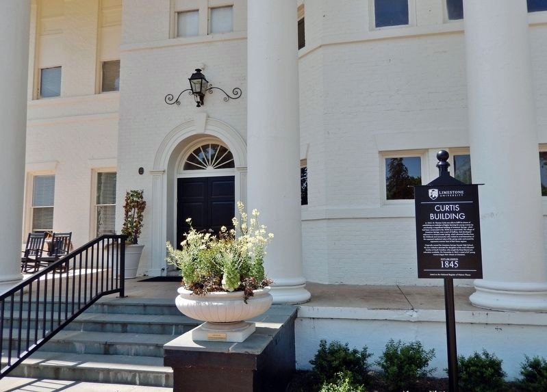
Built in 1851 with two class rooms for use while the main building was being completed.
Dr. James C. Furman used the south end,
Dr. Charles H. Judson, the north end.
Entrusted by action of the Trustees on June 10, 1910 to the Quaterion Club . . . — — Map (db m21170) HM
The Shack, built in 1937, served as a snack bar and rustic gathering place on the campus of the university's coordinated women's college until it was moved to Furman's new campus in 1961. Now a student residence, it is the only remaining structure . . . — — Map (db m20751) HM
Look around and you'll notice lumps in the terrain. These overgrown foundations are all that's left of wooden barracks that once housed the men who built this park.
The Civilian Conservation Corps (CCC) began work here in 1935, transporting . . . — — Map (db m20301) HM
Started in 1820 as St. James' Mission, the first church built here in 1825 on land given by Vardry McBee, was consecrated in 1828 by Bishop Nathaniel Bowen as Christ Church. The present church was built 1852-54 with Rev. John D. McCollough as . . . — — Map (db m8506) HM
Falls Cottage was originally used as a home by the Camperdown Mills Supervisor.
It has been many things including a home, gas station, and restaurant.
The West End became a settlement in the 1830s. — — Map (db m29900) HM
Greenville was a major textile center by the beginning of the twentieth century, and local cotton growers and brokers needed storage places for the harvested cotton. West End banker H.L. Gassaway and Dr. Davis Furman purchased land immediately . . . — — Map (db m8209) HM
Fountain Fox Beattie House
This house, built in 1834, first stood a few blocks south on East North St. It was built by Fountain Fox Beattie (1807-1863), a textile merchant, for his new bride Emily Edgeworth Hamlin. Their son Hamlin Beattie . . . — — Map (db m11036) HM
This plaque commemorates the 50th anniversary of Furman University's relocation from this site to the current campus north of Greenville on Poinsett Highway. From 1851 to 1958, Furman University was located atop this bluff above the Reedy River . . . — — Map (db m14540) HM
This building was erected by the citizens of the Greenville community as a tribute to that glorious heritage which inspired the development and formation of the American government and the freedoms to which it aspires and is dedicated to the men . . . — — Map (db m19197) HM
Circa 1880
Later
Nukasee Manufacturing
Restoration 1979-1890
Greenville County Historic
Preservation Commission
Vance B. Drawdy
Chairman
Romayne A. Barnes / John W. Grady, III
Laura Smith Ebaugh / Georgianna Graham
Mrs. . . . — — Map (db m17570) HM
The Cherokees
Greenville County was Cherokee Territory before the Revolution. European settlers were forbidden to live here until 1777, when Native Americans were forced to cede this land to the new state. Most of modern day Greenville was . . . — — Map (db m14535) HM
In honor of
Jennie McKay
Died September 25, 1932
and
Lilley McKay
Died September 26, 1941
Faithful members whose generosity
inspired this chapel — — Map (db m121929) HM
In 1935, this land was undeveloped acreage surrounding Greenville's outdated reservoirs. By 1937, it had been converted into a state park. Because boating and swimming in Lake Placid were the main attractions, a bathhouse was built overlooking . . . — — Map (db m20175) HM
Built in 1938 by the Works Progress
Administration, it was a part of
the largest WPA school project in
the state of South Carolina. The
auditorium was built at a cost of
$50,000 and named for Thomas F. Parker,
local mill executive. The . . . — — Map (db m30316) HM
(Front):
This early twentieth century suburb takes its name from Sans Souci, the nearby house and estate of Gov. Benjamin F. Perry (1805-1886). Perry, a prominent Unionist before the Civil War, was appointed provisional governor of S.C. . . . — — Map (db m15920) HM
This historic site, home of South Carolina's first nationally charted bank in 1873, has served as the cornerstone of the spirit of community banking in Greenville ever since. Carolina First Bank is honored to uphold the banking heritage that puts . . . — — Map (db m17337) HM
With the founding of the Greenville Missions in 1852 this parish, dedicated to Our Lady of the Sacred Heart of Jesus, became the Mother Church of Catholicism in the twelve counties of Upstate South Carolina which comprise the Piedmont Deanery of . . . — — Map (db m30221) HM
This site was occupied by the S.H. Kress Five and Dime Store building for many years. It was one of the centers of Greenville's vibrant downtown with its active and popular lunch counter. The building was rebuilt after a fire in its early years and . . . — — Map (db m180721) HM
The small two-story stucco-covered brick house overlooking the Reedy River falls was built by W.E. Touchstone between 1894 and 1896. It was located in the "West End," a rapidly developing residential and commercial area across the river from . . . — — Map (db m27007) HM
Multi Use House
The two-story stucco-covered brick house overlooking the Reedy River falls was built by W.E. Touchstone between 1894 and 1896. It was located in the "West End," a rapidly developing residential and commercial area across the . . . — — Map (db m27004) HM
(side 1) The Wilkins House was built in 1878 by Greenville builder Jacob Cagle for William Wilkins and his wife Harriett Cleveland Wilkins. The home, which originally fronted Augusta St., was designed in the Italianate style, but also . . . — — Map (db m133572) HM
The National Register
of Historic Places
101 Trade Street
Greer Downtown
Historic District
South Carolina
Department of Archives
And History — — Map (db m50206) HM
The history of the Gosnell cabin originates 200 years ago. The cabin, with original dimensions of twenty-five by eighteen feet, was built out of twelve-inch thick by eight-inch wide beams of heart pine, and it was built to last.
Gresham . . . — — Map (db m30397) HM
[Marker Front]:
This farm has been owned by the Hopkins family since 1834, when John Hopkins (1793-1837) purchased it from William Toney. The Greek Revival main house was built ca. 1840, with later additions ca. 1890 and ca. 1925. Hopkins' . . . — — Map (db m9068) HM
(front)
The Classical Revival building, constructed in 1940, was the Simpsonville Branch of the Greenville County Library until 1997. The first town library started ca. 1915 when Miss Nannie Cox, a literature teacher, placed books in the . . . — — Map (db m168359) HM
(side 1)
This house was the boyhood home and birthplace of John L. Plyler (1894-1966), a Furman University alumnus and Harvard Law School graduate who served as an attorney, judge, and dean of the Furman University Law School before . . . — — Map (db m85937) HM
Andrew Logan built this house in the late 1700s. The house was the first home built in the nearby town of Greenwood, SC and was actually found hidden in the core of an old house. It was moved here in 1968 where it was put under the protection of . . . — — Map (db m30719) HM
444 entries matched your criteria. Entries 201 through 300 are listed above. ⊲ Previous 100 — Next 100 ⊳