Pioneer Kennebec Loyalist Scott Family
Settled by Salmon River Arden 1855
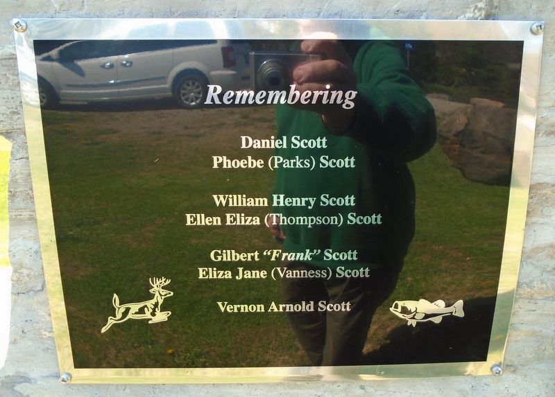
Daniel Scott [1822-1911] & Phoebe Parks [1815=c1891]
Children: Eunice, David, William, Dolly, Daniel
Remembering
Daniel Scott · Phoebe (Parks) Scott . . . — — Map (db m273621) HM
[Former Township Logo reads]
Township of Kennebec
Flying above the Rest
Incorporated 1862
—————————
This boulder comes from Buck Lake
site of the first settlement in an area
that has been known for over 180 years
by the Algonquin . . . — — Map (db m273618) HM
Surveyed in 1852-53 by Thomas Fraser Gibbs, Provincial Land Surveyor, this route was opened as part of a network of "colonization roads" planned by the government to encourage settlement in the southern region of the Precambrian Shield. Under the . . . — — Map (db m273701) HM
The World's War 1914 - 1918
While on Active Service
Died
No. 835541 · Pte H.R. Abbott · Mt. Grove 1916
Gassed
No. 835443 · Corp. A. Lewis · Avion June 4, 1917
Killed
No. 2129416 · Pte H.R. Cronk · Roy Road . . . — — Map (db m273678) WM
More than a pretty flower
The blue flag is a native herb, found in marshes, swamps, moist fields, and meadows from southern Saskatchewan to the Maritimes. In 1999, this large member of the iris family was adopted as the . . . — — Map (db m273734) HM
Benton's Cut was named by local railroaders in memory of K&P foreman Chancy Benton. When Colonel George Flower of New York took over the building of the railway, he was faced with the need of experienced men to supervise the work. He brought . . . — — Map (db m273963) HM
The caboose carried the conductor and
brakeman at the end of a freight train, so
they could monitor the air brakes, watch
for derailments, and throw track switches
when necessary. This caboose was built
in Montreal by CN Rail in 1976, and . . . — — Map (db m273807) HM
This livestock pen is a reproduction of the enclosure that stood on this site in the early twentieth century, to hold livestock brought to trackside by farmers for shipping to an abattoir. The reproduction was constructed of local hemlock and . . . — — Map (db m273809) HM
The building on the right in the photo with the wooden steps and porch is Sharbot Lake's first railway station. It was located here. The station was built by the Kingston and Pembroke Railway shortly after its track was laid through in 1876. . . . — — Map (db m273952) HM
This bell was once in the Presbyterian Church which was built in 1880 on the site of the current Masonic Lodge on Road 38 in Sharbot Lake. In 1923, the church was sold to the Masonic Lodge along with the bell. However, when the building burned . . . — — Map (db m273862) HM
These signs indicate the distance to the next station. They were originally placed on telegraph poles, and later on their own posts.
CPR drawing, 1915 [reads]
MILE PLATE
For detail, see punched out bridge No Plate above. . . . — — Map (db m273771) HM
This "speeder" manufactured by
Railcar Canada of South Lancaster ON
moved work or inspection crews
along the track. In the late 20th century
speeders were replaced by pickup
trucks with auxiliary "hi-rail" wheels.
[Illustration] . . . — — Map (db m273791) HM
Before the days of radio communication, train movement was controlled by a timetable and train order system. Orders were issued by a centralized dispatcher and sent to outlying station operators or agents via telegraph or telephone. The order . . . — — Map (db m273913) HM
During the steam era of the railway, the Pump House and its machinery played a pivotal role in ensuring the essential resource of water was available to the steam locomotives. Steam locomotives consumed large amounts of coal and water to produce . . . — — Map (db m286035) HM
This small motorized cart was probably manufactured by Fairmont Railway Motors of Minnesota. It was used by section crews to transport 1-2 workers along the track with their tools and spikes. More supplies could be carried on the trailer. The . . . — — Map (db m273762) HM
The items laid out on the trailer or "lorry" pulled behind the motor car, are typical tools used by a section gang. This crew was responsible for repairing and maintaining a section of track, and their tools had remained basically the same since . . . — — Map (db m273787) HM
This tree planted in memory of
Shirley Peruniak, 1926 - 2020
By the Central Frontenac Railway Heritage Society
and the Granite Ridge School Council
Shirley was the driving force in gathering local history,
stories and . . . — — Map (db m273910) HM
This box was used for holding a variety of materials at the Canadian National Railways Pointe St. Charles Shops in Montreal, where our Railway Heritage Park caboose was built in September 1976. The box was moved with a fork lift.
Photo by Ron . . . — — Map (db m273848) HM
In 1987, Sharbot Lake Beach was the site of 12 year old Simon Whitfield's first Kids of Steel Triathlon. In 2000, Simon became the inaugural gold medal winner in triathlon at the Sydney Australia Olympics.
Olympic Distance: 1500m swim, 40k . . . — — Map (db m273956) HM
The Angry Farmer
In the early days of the K&P, a local farmer, Bill Francis, who lived near the rail line, discovered that two of his cattle were killed after wandering onto the tracks. Feeling that the crew involved weren't showing the . . . — — Map (db m273841) HM
Before large trucks, reliable, refrigeration and the ability to freeze meat for transport existed, livestock was shipped by rail, in cattle cars. To facilitate this, stock pens for receiving and shipping the livestock were built in small . . . — — Map (db m273811) HM
On May 8, 1876, the Kingston and Pembroke Railway crossed The Narrows of Sharbot Lake on this rock-filled causeway. In 1882, as the construction of the Ontario and Quebec Railway (later the Canadian Pacific Railway) pushed through Sharbot Lake, . . . — — Map (db m273971) HM
From here, the Kingston and Pembroke Railway headed
north. Incorporated in 1871, the Kingston and Pembroke
Railway Company was chartered to run between the two
towns with the purpose of gaining access to the forests and
minerals found in the . . . — — Map (db m273759) HM
This bar with a point on one end can be used for aligning rails, "nipping" a tie to start a spike, or for prying. It can also serve as a jack handle, but the round end should not be used in a bolt hole to roll a rail!
[Uncaptioned photo of . . . — — Map (db m273789) HM
Because the trackbed of the Kingston & Pembroke Railway was built during the "hard times" of the depression in the 1870s, as little money as possible was spent on it. Grades were steep and curves were plentiful. With stops every 5 miles or so, . . . — — Map (db m273840) HM
Kingston and Pembroke Railway
Affectionately known as the Kick and Push, it was incorporated in 1871 to run from Kingston to Pembroke. The K&P crossed Sharbot Lake on a rock-filled causeway, May 8, 1876. The line was opened to . . . — — Map (db m273856) HM
[Kingston and Pembroke Iron Mining Company stock certificate excerpt]
With the arrival of the railway in 1876 came new prosperity. Sawmills & mines now had easy access to markets. Sharbot Lake soon had several stores, hotels & 3 doctors. . . . — — Map (db m273921) HM
In 1888, the Kingston & Pembroke Railway built the Union Hotel on this site at the junction of the K&P and the CPR lines. The hotel catered to labourers, tourists and fishermen. When Herb and Millie Moyst purchased the hotel in 1946, it became . . . — — Map (db m273918) HM
The station was built circa 1884 by the Canadian Pacific Railway. The William C. Van Horne inspired
design was a simple two-storey building with the Agent's quarters on the second floor and a waiting
room, ticket office (the protruding windows) . . . — — Map (db m273738) HM
Known locally as the "fisherman's hotel", the Union Hotel
was built circa 1889 and named to reflect the junction of the
K&P, Ontario and Quebec Railways. Built by the Kingston
and Pembroke Railway, it was later called the Sharbot
Lake Hotel, . . . — — Map (db m273912) HM
This is the former site of a 40,000 gallon water tower which was removed in 1964. The original wooden one (inset) was replaced with a more modern steel version. Lake water was pumped to the tower and flowed through underground piping to . . . — — Map (db m273817) HM
Signalmen used these small carts to hold their tools and supplies. The carts were pushed along the track but could be lifted off when a train was approaching. This one was built by Transport Products
Corp. in Louisville, Kentucky. — — Map (db m273767) HM
This gasoline-powered tug manufactured by the Whiting Corp. is used for moving railway cars on the track. It has road wheels as well as steel wheels (missing on this example) so it can move from track to track, and be stored off the track. Its . . . — — Map (db m273824) HM
This motor was used to turn locomotives around, and is similar to a motor seen here on the K&P turntable in Kingston.
It was mounted vertically on the side of the turntable (see the detail photo) and was powered by compressed air produced by . . . — — Map (db m273838) HM
Dedicated in honour of
all Veterans who served in
the Armed Forces of Canada
1914 - 1918
1939 - 1945
The Korean War
[Dedicated] November 11, 1987 — — Map (db m273919) WM
Sharbot Lake was the intersection of the original Canadian Pacific Toronto to Montreal mainline and the Kingston & Pembroke Railway. You are now just east of where the lines separated after sharing a right of way from south of the village. See . . . — — Map (db m273808) HM
This sign indicates an area where trains are allowed to move at restricted speed with verbal permission from a yardmaster, rather than under signal light control. A yellow lamp can be placed
behind the round hole.
CPR [Yard Limit sign . . . — — Map (db m273804) HM
English:
Designed by the Montréal architectural firm of Hopkins, Lawford and Nelson, the Kingston Custom House was built in 1856-59 for the government of the united Canadas. The symmetrical composition of the two-storey ashlar . . . — — Map (db m140194) HM
This building is named in honour of Mary (Molly) Brant (c.1736-1796),
matriarch and influential leader of the Mohawk Nation and her
younger brother, Joseph Brant (c. 1742-1807), Mohawk war leader.
Both were instrumental in maintaining the . . . — — Map (db m309157) HM