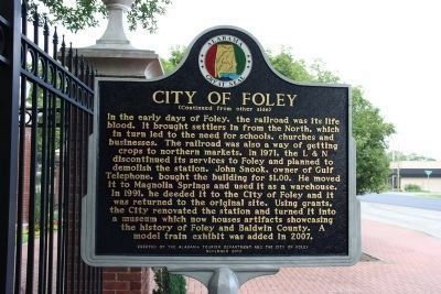
The City of Foley was founded in 1905 by John B. Foley of Chicago. Mr. Foley, who was in the pharmaceutical business, heard about this area from a railroad land agent as they traveled to President William McKinley's funeral in 1901. Mr. Foley . . . — — Map (db m188732) HM
An elegant blend of Greek Revival and Italianate architectual styles, the Thompson Mansion reflects the aesthetic and economic highs of the 1850s. The symmetrical layout of the house with entrances on all four sides features interior cross hallways . . . — — Map (db m71400) HM
[Written on the initial marker, provided for context]
Our Constitution names the President of the United States the Commander in Chief of all the Armed Forces. Presidents who have served in our military are displayed on the following plaques. . . . — — Map (db m92421) HM WM
Jacob Trieber served as United States District Judge for the Eastern
District of Arkansas from 1901 to 1927. He was the first Jewish judge
ever to serve on the federal bench. Trieber was born in Prussia in
1853, immigrated with his parents to St. . . . — — Map (db m107824) HM
McKinley Rose Garden Park History McKinley Park, as we know it today, was opened in 1871 as the privately owned East Park, a name given to it for its location in the undeveloped area, just east of city limits. As a ploy to increase street-car . . . — — Map (db m137486) HM
Burns Slough
McKinley Park has a rich and fascinating history. It began as a natural low swampy area with a flowing stream called Burns Slough. In 1868, levee construction to prevent flooding of Sacramento cut the slough off from the American . . . — — Map (db m137570) HM
On April 21, 1898, the United States declared war against Spain. The immediate causes were America’s support of Cuba’s ongoing struggle against Spanish rule and the mysterious explosion of the USS Maine in Havana Harbor. This was the first . . . — — Map (db m284754) HM
On the night of April Thirtieth 1898 Commodore Deweys squadron entered Manila Bay and undaunted by the danger of submerged explosives reached Manila at dawn of May First 1898 • Attacked and destroyed the Spanish fleet . . . — — Map (db m15075) HM WM
St. James Park and its environs were the heart of nineteenth century San Jose. While the Plaza has been the center of the older Hispanic settlement, St. James Park and its surrounding buildings reflect the aspirations of an emerging American city. . . . — — Map (db m52561) HM
Est. and in continuous operation since 1862. “The Willow Hotel” was named for the trees that were growing here long before the Gold Rush started. In its heyday The Willow hosted President McKinley, Mrs. Robert E. Lee and “Bat” Masterson among . . . — — Map (db m301040) HM
Bachelor Cabins, also known as New Carson, is not to be confused with high altitude Old Carson which dates to 1882 when Joseph Christopher Carson — no relation to the famed scout — discovered the Bonanza King Mine on the treeless, 12,500'-elevation . . . — — Map (db m292491) HM
First settled by families from East Windsor in 1716 and originally a part of East Windsor and Bolton, the Town of Vernon was incorporated in 1808 by division of the Town of Bolton. In 1889 the City of Rockville, named from the Rock Mill, was . . . — — Map (db m111842) HM
A New Catholic Church was first planned in 1896. This Victorian Gothic building was completed and dedicated on July 5, 1897. This building is described by the Ridgefield Preservation Trust as "… one of Ridgefield's finest buildings…a complex . . . — — Map (db m32049) HM
This residence was designed by architect Appleton P. Clark, Jr. and built in 1891 for Daniel Birtwell. In 1900, George Bruce Cortelyou occupied the house when he became secretary to President McKinley. Cortelyou continued to serve in public office . . . — — Map (db m69292) HM
Theodore Roosevelt resided in a number of houses in Dupont Circle. Two still standing are 1215 19th St. and 1820 Jefferson St. In 1898, he lived at 1810 N St. (below, since razed). That year he led a volunteer cavalry called the Rough Riders . . . — — Map (db m96038) HM
The house at #4 Logan Circle, built in 1878, was the 1880's home of Senator John A. Logan. In the Civil War, Logan's military valor helped to save the Union. In the postwar era, Logan lived here as a political leader deeply committed to achieving . . . — — Map (db m153985) HM
The house at #4 Logan Circle, built in 1878, was the 1880's home of Senator John A. Logan. In the Civil War, Logan's military valor helped to save the Union. In the postwar era, Logan lived here as a political leader deeply committed to achieving . . . — — Map (db m195513) HM
“We should guard their graves with sacred vigilance. All that the consecrated wealth and taste of the Nation can add to their adornment and security is but a fitting tribute to the memory of her slain defenders.” John A. . . . — — Map (db m53016) HM
Pierre L'Enfant's 1791 design for the Nation's capital featured a prominent triangle formed by the "President's House" and two intersections: Pacific Circle, located to the northwest of the presidential residence, and Iowa Circle, to the northeast. . . . — — Map (db m153986) HM
Wrapping the corner across Rhode Island Avenue is Asbury Dwellings for senior citizens. In 1901 it opened as the city's white-only McKinley Technical School, memorializing slain President William McKinley (1843-1901). In 1928 the "colored" . . . — — Map (db m130845) HM
James Wilson Memorial Arch
So named by the Congress, in Resolution approved by
President Franklin D. Roosevelt, June 16, 1934,
to honor the memory of
James Wilson
1835-1920
Secretary of Agriculture 1897-1913
. . . — — Map (db m110425) HM
Century, Florida Founded in 1900 to house mill employees of the Alger-Sullivan Lumber Company, formed in 1900 by General Russell A. Alger - Governor of Michigan, U.S. Senator, and President McKinley's Secretary of War - and by Martin H. . . . — — Map (db m102557) HM
The Philippine-American War, also known as the Philippine War of Independence or the Philippine Insurrection (1899 -1902), was an armed conflict between the United States and Filipino revolutionaries. The conflict arose from the struggle of the . . . — — Map (db m194588) HM WM
February 15, 1898
Sinking Of The USS Maine
April 19, 1898
U.S. Adopts Joint Resolution For War
April 25, 1898
U.S. Declares War On Spain
May 1, 1898
Battle Of Manila Bay
. . . — — Map (db m152467) WM
“You triumphed over obstacles which would have overcome men less brave and determined.”President McKinley Dedicated to The Veterans of 1898 to 1902 by the Camps and Auxiliaries of the Department of Georgia United States War . . . — — Map (db m120240) WM
“You triumphed over obstacles which would have overcome men less brave and determined”
President McKinley
(On base of soldier):
Hiker of ‘98
Dedicated to the Veterans of 1898 -1902
By the Camps and Auxiliaries . . . — — Map (db m62952) WM
These cannon, which were captured when Lord Cornwallis surrendered at Yorktown in the American Revolution, were a gift to the Chatham Artillery by President George Washington - a mark of his appreciation for the part the local military company . . . — — Map (db m5517) HM
“You triumphed over obstacles which would have overcome men less brave and determined”
President McKinley
Hiker of ’98 (On base of soldier)
Dedicated to the Veterans of 1898 -1902
By the Department of Georgia and . . . — — Map (db m62953) WM
“You triumphed over obstacles which would have overcome men less brave and determined”
President McKinley
Dedicated to the Veterans of 1898 - 1902
By Department of Georgia
National Auxiliary United Spanish War Veterans . . . — — Map (db m60433) HM
“You triumphed over obstacles which would have overcome men less brave and determined”
President McKinley
Dedicated to the Veterans of 1898 to 1902 Camps and Auxiliaries of the Department of Georgia
United Spanish War . . . — — Map (db m57362) HM
This stone erected by the citizens of Richmond County, Georgia marks the spot where President William McKinley descended from the railroad train on the occasion of his visit to Augusta, Georgia on December 19th, 1898. The name of McKinley Avenue has . . . — — Map (db m200114) HM
"You Triumphed Over Obstacles
Which Would Have Overcome Men
Less Brave And Determined"
President McKinley
Dedicated to
The Veterans Of 1898 to 1902
by Department of Georgia National Auxiliary . . . — — Map (db m10187) HM
Here stood the small frame house in which Lazarus Straus and his family lived when they came to Talbotton in 1854. Seeking a new home in America after leaving Bavaria, Straus visited Talbotton during a “court week” and decided to make . . . — — Map (db m38249) HM
In 1898 the Spanish-American war allowed the South to demonstrate its loyalty and honor under fire. At first, secretary of war Russell A. Alger, was concerned that Southerners would not support the war due to bitterness over losing the Civil War. He . . . — — Map (db m82710) HM
Chicago’s Boulevards are one of the city’s most overlooked treasures, and one of the largest and oldest boulevard systems in the nation. The 28-mile system contains 540 acres of green space, and provides a link between seven inland parks and . . . — — Map (db m189232) HM
Chicago’s Boulevards are one of the city’s most overlooked treasures, and one of the largest and oldest boulevard systems in the nation. The 28-mile system contains 540 acres of green space, and provides a link between seven inland parks and . . . — — Map (db m241131) HM
Chicago’s Boulevards are one of the city’s most overlooked treasures, and one of the largest and oldest boulevard systems in the nation. The 28-mile system contains 540 acres of green space, and provides a link between seven inland parks and . . . — — Map (db m244568) HM
Camp Douglas Prison
Camp Douglas was established as a Union training camp on the south side of Chicago. When Fort Donelson, a Confederate stronghold on the Cumberland River west of Clarksville, Tennessee, surrendered in February 1862, the . . . — — Map (db m232642) HM
Chicago’s Boulevards are one of the city’s most overlooked treasures, and one of the largest and oldest boulevard systems in the nation. The 28-mile system contains 540 acres of green space, and provides a link between seven inland parks and . . . — — Map (db m234583) HM
Chicago’s Boulevards are one of the city’s most overlooked treasures, and one of the largest and oldest boulevard systems in the nation. The 28-mile system contains 540 acres of green space, and provides a link between seven inland parks and . . . — — Map (db m249820) HM
Chicago’s Boulevards are one of the city’s most overlooked treasures, and one of the largest and oldest boulevard systems in the nation. The 28-mile system contains 540 acres of green space, and provides a link between seven inland parks and . . . — — Map (db m314155) HM
Chicago’s Boulevards are one of the city’s most overlooked treasures, and one of the largest and oldest boulevard systems in the nation. The 28-mile system contains 540 acres of green space, and provides a link between seven inland parks and . . . — — Map (db m314205) HM
Chicago’s Boulevards are one of the city’s most overlooked treasures, and one of the largest and oldest boulevard systems in the nation. The 28-mile system contains 540 acres of green space, and provides a link between seven inland parks and . . . — — Map (db m189227) HM
Chicago’s Boulevards are one of the city’s most overlooked treasures, and one of the largest and oldest boulevard systems in the nation. The 28-mile system contains 540 acres of green space, and provides a link between seven inland parks and . . . — — Map (db m110744) HM
Chicago’s Boulevards are one of the city’s most overlooked treasures, and one of the largest and oldest boulevard systems in the nation. The 28-mile system contains 540 acres of green space, and provides a link between seven inland parks and . . . — — Map (db m273249) HM
McKinley Park, which was dedicated in 1902, is one of the first "neighborhood parks" in the country. Named in honor of President William McKinley, who had been assassinated one year earlier, McKinley Park proved to be an instant success. The park's . . . — — Map (db m258380) HM
Chicago’s Boulevards are one of the city’s most overlooked treasures, and one of the largest and oldest boulevard systems in the nation. The 28-mile system contains 540 acres of green space, and provides a link between seven inland parks and . . . — — Map (db m249341) HM
[First tablet on the left:]
American Civil War
April 12, 1861 April 26, 1865
Initiating the conflict between the industrial based north and agriculturally based south was the southern bombardment of Fort Sumter on April 12, 1861. This . . . — — Map (db m245161) WM
Abraham Lincoln probably stayed at the Hamilton House when he came to Carthage in 1839 to serve as the defendant's counsel in the Fraim murder trial. There are no other known Lincoln court cases in Hancock County. But he did handle . . . — — Map (db m57867) HM
Major Campaigns and Deaths
San Juan Heights/El Caney, Cuba (6/98-7/98) 1,475
Cuba Campaign (6/98-8/98) 350
Battle of February 4th, Philippines (2/99) 60
Balangiga Massacre, Philippines (9/01) 48
Manila, Philippines . . . — — Map (db m94845) WM
During his presidency, Abraham Lincoln had promised to care for the men in the armed services-and for their widows and orphans. Lincoln was unable, however, to keep that promise. In response, the Grand Army of the Republic or G.A.R. . . . — — Map (db m56908) HM
Alton Military Prison
In late 1861, Union Gen. Henry Halleck received permission to use the former Illinois State Penitentiary in Alton, Illinois, as a military prison. The old prison had 256 cells, a hospital, a warden's house, and . . . — — Map (db m154164) HM
Camp Butler Prison Camp
On February 16, 1862, Fort Donelson, a Confederate stronghold on the Cumberland River west of Clarksville, Tennessee, surrendered. Faced with 15,000 prisoners, the U.S. Army converted several training camps, . . . — — Map (db m159004) HM
Historical Society
Organized 1897. Headquarters and Genealogical Library in Museum building.
Birthplace of John Hay
Built in 1824 as a school. John Hay, Secretary to pres. Lincoln and Secretary of State for Presidents McKinley and . . . — — Map (db m46803) HM
What is Kansas? April 25, 1922 in the Judge by William Allen White
Kansas is a state of the Union, but it is also a state of mind, a neurotic condition, a psychological phase, a symptom indeed, something undreamt of in your . . . — — Map (db m49799) HM
To stimulate the patriotism of the Spanish-American War, President McKinley suggested a new pledge of allegiance be written and ask[ed] the patriotic organizations take charge of it.
When the contest was over, the honor of writing the "Pledge . . . — — Map (db m61436) HM WM
"You triumphed over obstacles which would have overcome men less brace and determined." President McKinley
438 131
Every man a volunteer
Erected in honor of the veterans of the Spanish-American War by the Department of Kentucky . . . — — Map (db m143048) WM
When the U.S.S. Maine was commissioned in 1895, it was the first modern American battleship, and the first modern U.S. Navy warship to be built in an American shipyard of materials and components manufactured in the United States. The Maine . . . — — Map (db m186041) HM WM
When the B&O railroad finally arrived in Cumberland on November 5, 1842, there was cause for celebration. The railroad would soon reap big rewards from the valuable coal reserve of the Cumberland basin. The ultimate goal at that time was to . . . — — Map (db m256766) HM
History
Once, a thriving community prospered here along the banks of the Little Patuxent River. Guilford was a center for milling, quarrying, and cotton=cloth production in the late 18th through the early 20th centuries. It featured . . . — — Map (db m19884) HM
Camp Hoffman Prison
The Union prison at Camp Hoffman, Maryland — called Point Lookout — opened in 1863. A 15-foot-high plank fence surrounded the 40-acre prison compound. The first prisoners arrived in July 1863-Confederates . . . — — Map (db m128948) HM WM
"In October 1877, Bench Mark "A" was cut on the water table of the recently rebuilt courthouse in Hagerstown, Maryland", reads the report of the coast and geodetic survey to President McKinley. This was the beginning point of a . . . — — Map (db m6529) HM
Douglas was raised at Ferry Hill Place, on the Maryland side of the Potomac River at Shepherdstown. In 1861, he enlisted in the 2nd Virginia Infantry and fought in the Battle of First Manassas. From April to October, 1862, Douglas was the youngest . . . — — Map (db m107394) HM
(Front Inscription): OHIO
23d Infantry
Commanded by
Major James M. Comly
Hugh Ewing's (1st) Brigade
Kanawha Division
Ninth Army Corps
Army of the Potomac (Rear Inscription):
This Regiment with its Brigade . . . — — Map (db m6669) HM
(Front):
William McKinley
January 29, 1843 - September 14, 1901
(Rear):
Fourteen Years Member of Congress
Twice Governor of Ohio 1892-3 and 1894-5
Twice President of United States 1897-1900 and 1901.
Sergeant McKinley . . . — — Map (db m173317) HM
[West Face]
"Let us remember that
our interest is in concord
not conflict - and that our
real eminence rests in
the victories of peace
not those of war"
From President McKinley's Address at Buffalo
September VI MDCCCCI
[Bas-relief . . . — — Map (db m118599) HM WM
This cannon, captured in the Spanish-American War by Admiral Dewey, was presented to Three Oaks when its citizens raised $1,400 for a memorial to the men of the battleship Maine. This was the largest contribution, per capita, of any community in the . . . — — Map (db m1603) HM
Among the many contributions to the Industrial Revolution few are more important than the lubricating cup, invented by Elijah McCoy. He was born in Canada, educated in Scotland and made Ypsilanti his home. As a fireman on the Michigan Central . . . — — Map (db m103321) HM
Story adopted from "On This Day In History: The Battle of Sugar Point" by Kayla Duoos, Leech Lake News, Oct. 5, 2020 On the early Wednesday morning of October 5th, 1898, a handful of young Pillager Ojibwe men held off . . . — — Map (db m266796) HM
James J. Hill
"Most men who have really lived here have had, in some shape, their great adventure. This railway is mine," wrote James J. Hill to the Great Northern Railway employees upon his retirement in 1912. Throughout his long working . . . — — Map (db m231549) HM
On July 20, 1899, Giuseppe Di Fatta, Pasquale
Di Fatta, Francesco Di Fatta, Giovanni Cerami
and Rosario Fiduccia, all natives of Sicily, were
murdered by a lynch mob in Tallulah, Louisiana.
The murders triggered an international . . . — — Map (db m236878) HM
When William McKinley, the 25th president of the United States (1897-1901), visited Vicksburg on May 1, 1901, cotton was “king” in Vicksburg and Warren County, as is evidenced by this arch of cotton bales (each weighing about 450 pounds) that . . . — — Map (db m190968) HM
Davis-Mitchell House (1872)
Dr. Charles Mitchell built the house in 1872 for his wife Lucy Bradford who was Jefferson Davis's niece. In 1884 this small house became the first office for the U. S. Army Corps of Engineers in Vicksburg. . . . — — Map (db m115421) HM
Military Prison in St. Louis
St. Louis had two small Civil War prisons, each housing several hundred persons. Gratiot Street Prison was the former McDowell Medical College, located near Eighth and Gratiot streets and the Mississippi River. . . . — — Map (db m124972) HM
In 1898, following the financial panic of 1893 and the droughts of 1894-95, a world-class
exposition was held in Omaha under the guidance of Gurdon W. Wattles and other civic leaders.
The Trans-Mississippi and International Exposition emulated . . . — — Map (db m33044) HM
At this site in 1898, Omaha hosted the Trans-Mississippi and International Exposition. Following the model of other “world's fairs,” the exposition highlighted the “Progress of the West,” drawing over 2.5 million admissions. . . . — — Map (db m33018) HM
April 12, 1861: Fort Sumter, South Carolina was fired on by Rebel forces. On the 18th of May, Nebraska Territory Governor Alvin Saunders issued a proclamation calling for volunteers to either answer the call from President Lincoln for service in . . . — — Map (db m48286) HM
Built in 1879.
Named for the seven U.S. Presidents who attended services here: Ulysses S. Grant, Rutherford B. Hayes, James A. Garfield, Chester A. Arthur, Benjamin Harrison, William McKinley, and Woodrow Wilson.
Deconsecrated in 1953, . . . — — Map (db m14049) HM
Elmira Prison Camp
Overcrowding at the military prison at Point Lookout, Maryland, led the U.S. Army to establish Elmira Military Prison in May 1864. Elmira, New York, initially a rendezvous point for enlisting Union soldiers, had barracks, . . . — — Map (db m90076) HM
Founded 1867, with Millard Fillmore 13th President of U.S., as its first president. Another U.S. President, Grover Cleveland, was a member from 1881-1908. In 1901, after President McKinley's assassination, the club was used as headquarters by his . . . — — Map (db m75836) HM
Extending one mile north from Delaware Park Lake, between Elmwood and Delaware Avenues, the Pan-American Exposition was a spectacular sight to over eight million visitors from May 1 to November 2, 1901. Ornate buildings, embellished with . . . — — Map (db m57079) HM
Conceived in 1804 by Joseph Ellicott (right), Niagara Square was the beginning of what renowned landscape architect Frederick Law Olmsted would in mid-century call "the best planned city as to its streets, public places, and grounds in the United . . . — — Map (db m92820) HM
[west side] William McKinley was elected to Congress as a representative from Ohio in 1876, '78, '80, '82, '84, '86, '88, was elected Governor of Ohio in 1891 and 1893 and President of the United States in 1896 and 1900. [south side] William . . . — — Map (db m92791) HM
1655: Seneca Indians win control of Niagara Region from Erie tribes. 1678-79: French explorer Rene-Robert Cavelier, Sieur de la Salle, claims the region for France. He builds a sailing ship, Griffon, on the bank of the Niagara River and . . . — — Map (db m80361) HM
Tree planted November 30, 1925 by Wm. Richardson Woman’s Relief Corps No. 59 Auxiliary to the Grand Army of the Republic in honor of Bidwell-Wilkenson Post No. 9 Grand Army of the Republic;
Bidwell Post No. 9 organized April 1, 1870;
J.W. . . . — — Map (db m138864) WM
On September 6. 1901. Vice President Theodore Roosevelt was vacationing
in the Town of Newcomb when he was informed of an attempt on the life of
President William McKinley. The President had been shot while receiving
visitors at the . . . — — Map (db m147316) HM
Near this point while driving hastily from Tahawus Club to North Creek at 2:15 A.M. Sept 14 1901 Theodore Roosevelt became President of the United States as William McKinley expired in Buffalo
Relay Drivers
David Hunter • Upper Works to Lower . . . — — Map (db m137860) HM
Theodore Roosevelt became President of the United States while in Newcomb during the early morning hours of September 12th, 1901. Earlier in the day he was descending from Mount Marcy when a guide reached him with information that President McKinley . . . — — Map (db m147527) HM
A Mining Town On The Hudson
This stretch of the Hudson River valley was occupied by a growing mining community, following the discovery of rich iron ore in 1826, and continuing until 1858.
Mining operations ceased and the village was . . . — — Map (db m147514) HM
This cottage has stood on this site for nearly two centuries; it is the only building that survives from the early mining community. The cottage first housed iron mine owners, later caretakers of the abandoned village, then members of a hunting . . . — — Map (db m147520) HM
Rich in history, the plain of Claremont Playground has been the site of a Revolutionary War battle, a country estate, a fashionable inn, and a children’s recreation area. This was the scene of fierce combat during the Battle of Harlem . . . — — Map (db m53992) HM
This small park is at the crossroads of several dynamic New York neighborhoods: Little Italy and the Bowery to the east, Chinatown to the south, and SoHo to the west and north. The site/area became parkland as a result of the City Charter of 1938, . . . — — Map (db m133620) HM