On East Lincolnway Street east of South Cedar Street, on the right when traveling east.
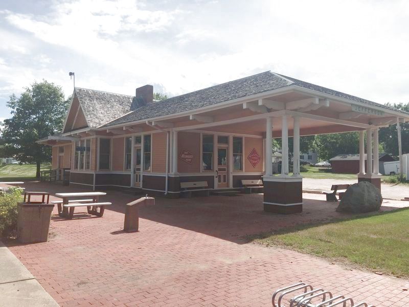
In 1881, a narrow gauge rail line was built by the Wabash, St. Louis and Pacific Railroad from Des Moines through Green County to Spirit Lake. Ten years later, it was widened to standard gauge and taken over by the Milwaukee Road until . . . — — Map (db m168832) HM
On East Lincolnway Street west of North Chestnut Street, on the right when traveling west.
Friday Club of Jefferson, the oldest Federated club in Greene County and one of the oldest in the state, was founded by eight local women on January 8, 1888 as the Ladies Reading Circle. The name was changed to Friday Club in 1899. The organization . . . — — Map (db m168834) HM
On Lincolnway Street near South Mulberry Street, on the right when traveling east.
North Side
[1919 US Army Convoy along the Lincoln Highway US Highway 30]
West Side
[The Medal of Honor with Captain Darrell R. Lindsey's crippled B-26 Marauder bomber]
East Side
[Astronaut Loren J. Shriver and POW . . . — — Map (db m168830) WM
On East Lincolnway Street, 0.1 miles west of North Chestnut Street, on the right when traveling west.
Judge Robert Montgomery Rippey, early-day Greene County settler and namesake of the town of Rippey, surveyed the entire county in 1854, the year Greene County was formally organized. He and two partners drove mule and oxen teams to Burlington in the . . . — — Map (db m168833) HM
The Lincoln Highway, the nation's first east-west transcontinental highway, has an intimate history with Greene County. Stretching from New York City to San Francisco, its original construction was essentially a private promotional effort, created . . . — — Map (db m168843) HM
On East Lincolnway Street east of South Wilson Avnue.
Sally lived in the Greene County town of Churdan. Married to Paul White they were the parents of three children; Julie, Rick and Cari. Sally had always been interested in photography. With the loving persistence of here husband, Paul, she used that . . . — — Map (db m168839) HM
On East Lincolnway Street east of South Wilson Avenue, on the right when traveling east.
Built in 1900, this is the original site of Kendall's Pool Hall. Fred and L.B. Kendal built this Prairie Craftsman style building in 1916 after fire destroyed the original wood structure.
This building operated as Kendall's Pool Hall until . . . — — Map (db m168842) HM
On Grundy Avenue west of North Church Street, on the right when traveling west.
(South Side)
Welcome to Grundy County
And the
Black Dirt Capital of the World
[Four young men and women walking right off the farm straight into the war effort.]
(North Side)
[The B-29 bomber "The City of Grundy Center"] . . . — — Map (db m167924) WM
On North 5th Street (State Highway 25) at Main Street, on the right when traveling north on North 5th Street.
In honor and memory of Prominent Pioneers and Builders of Guthrie Center who were active and influential characters during the decades named 1850-1870 William M. Tracy • Eder B. Newton • Thomas Seely Charles Huxley • William . . . — — Map (db m239782) HM
On North 5th Street (Iowa Route 25) at Main Street, on the right when traveling north on North 5th Street.
Names of women, pioneers in the settlement and development of Guthrie Center. Co-workers at planting time, their practical services and inspiring ideals are here acknowledged and memorialized. Tracy, Mrs. William • Seely, Mrs. Thomas • Margart, . . . — — Map (db m239700) HM
On East Main Street (State Highway 44) just east of Southeast 6th Street, on the right when traveling east.
Guthrie County Est. 1851 History Panora is located in eastern Guthrie County along the Western Skies Scenic Byway and the old Milwaukee Railway, which is now called the Raccoon River Valley Recreational Trail. Established in 1851, Panora is . . . — — Map (db m238347) HM
On West Main Street (State Highway 44) just west of North 1st Street, on the right when traveling west.
Background The Western Skies Scenic Byway, dedicated in 1998, is among the first state designated scenic byways in Iowa. The Byway is 142-miles long, traveling through Harrison, Shelby, Audubon and Guthrie Counties, and 14 rural . . . — — Map (db m238319) HM
On State Street at West 4th Street, on the right when traveling south on State Street.
Patriotism • Devotion This tablet is cast from metal recovered from the U.S.S. Maine. Presented to the City by the John Stanton Chapter — D.A.R. — — Map (db m176306) WM
Near Lincoln Highway (U.S. 30) just west of Monroe Avenue, on the right when traveling west.
In 1912, there were approximately one million motor vehicles registered in the United States but few good roads. Most of the roads outside of urban areas were dirt that turned to mud when wet. Long-distance travel by car was still very much a . . . — — Map (db m162418) HM
Near Lincoln Highway (U.S. 30) just west of Monroe Avenue, on the right when traveling west.
Ninety percent of Iowa's land area is in agriculture, the highest of any state in the United States. As you travel the roads in Iowa, you will notice most of the crops are one of two types: corn or soybeans. Corn Native to central Mexico, where . . . — — Map (db m162420) HM
Near Lincoln Highway (U.S. 30) just west of Monroe Avenue, on the right when traveling west.
Loess Light-weight grains of feldspar, quartz, and mica are the material of loess. It is homogenous, clayless, and porous. The Hills are strengthened with a dry climate and endangered by erosion when excessive moisture occurs. The . . . — — Map (db m162417) HM
On Huron Street, 0.1 miles east of Shawmult Street, on the left when traveling west.
Left column
God Bless America
Seals of Armed Forces Center column
In Honor of All Those Who Served This Great Nation in War and Peace Time
American Flag . . . — — Map (db m30575) WM
Near Lincoln Highway (U.S. 30) just west of Monroe Avenue, on the right when traveling west.
The Loess Hills of Western Iowa are made of wind-blown soils that are highly susceptible to erosion if not protected by a patchwork of conservation practices. All throughout the Loess Hills region, farmers use multiple practices, placed in specific . . . — — Map (db m162419) HM
On North Broadway Street south of East Broad Street, on the left when traveling south.
Commitment to Educational Excellence Born August 23, 1846, Bell Babb Mansfield moved to Mount Pleasant — known as “the Athens of Iowa” — in 1860. At Iowa Wesleyan University, she earned the B.A. in 1866, M.A. in 1870, and LL.D. in 1872. . . . — — Map (db m177823) HM
On West Courtland Street at Hickory Avenue, on the right when traveling west on West Courtland Street.
With the assistance of Senator James Harlan, the War Department authorized a military training camp at Mount Pleasant in October of 1861. The first recruits began arriving that September at Camp Harlan, which was designated as a cavalry training . . . — — Map (db m92519) HM
On West Courtland Street at Hicakory Avenue, on the right when traveling west on West Courtland Street.
This marks the site of
Camp Harlan
used as a training camp by
the 4th Iowa Cavalry and
the 25th Iowa Infantry
during the Civil War
Dedicated by
Belle Coddington Tent No. 34
Daughters of Union Veterans
of the
Civil War . . . — — Map (db m92520) HM
Near North Main Street north of East Pearl Street, on the right when traveling north.
Established by the Southwest German Conference of the Methodist Episcopal Church in affiliation with Iowa Wesleyan College for the theological training of German Methodist ministers to serve area German-speaking churches Historical marker erected in . . . — — Map (db m177879) HM
On East Washington Street (Business U.S. 34) just east of South Main Street, on the right when traveling east.
In honor of those who served In tribute to those who perished In gratitude to those now serving Avenue of Flags of Henry County Iowa Veterans Memorial[south side]Medal of Honor Recipients from Henry County Charles A. Swan USA . . . — — Map (db m240483) HM WM
On North Jefferson Street at West Madison Street, on the right when traveling north on North Jefferson Street.
Home of James Harlan, 1857-1873 Pres., Iowa Wesleyan University, 1853-1855 United States Senator, 1855-1865; 1867-1872 Secretary of the Interior, 1865-1866 — — Map (db m177889) HM
Near North Broadway Street south of East Broad Street, on the left when traveling south.
Iowa Wesleyan College Founded 1842 Pioneer Building Erected 1843 In commemoration of the first college west of the Mississippi River This tablet is dedicated by the James Harlan Chapter Daughters of the American Revolution Mt. . . . — — Map (db m177855) HM
On West Broad Street at North Main Street, on the right when traveling west on West Broad Street.
Harlan moved to Iowa in 1845, and was elected state superintendent of public instruction two years later. He became President of Iowa Wesleyan University in 1853, and was elected to the U.S. Senate in 1855. After winning a second term, President . . . — — Map (db m33116) HM
Near North Broadway Street south of East Broad Street, on the left when traveling south.
January 21, 1869 The P.E.O. Sisterhood was founded in Old Main’s second floor music room by seven Iowa Wesleyan University female students. P.E.O. is a philanthropic educational organization motivating women to achieve their highest . . . — — Map (db m177812) HM
On East Washington Street (Business U.S. 34) just east of South Main Street, on the right when traveling east.
With the faith and courage of their forefathers who made possible the freedom of these United States The Boy Scouts of America dedicate this copy of the Statue of Liberty as a pledge of everlasting fidelity and loyalty The Crusade to . . . — — Map (db m177111) HM
On North Broadway Street south of East Broad Street, on the left when traveling south.
Belle Babb Mansfield, first U.S. woman attorney 1869. Elected Pres., Iowa Woman Suffrage Convention 1870. Taught at IW 1873-1881. — — Map (db m177820) HM
On West Main Street at South Maple Street, on the left when traveling west on West Main Street.
Railroad Crossing Signs A number sign under the crossbuck indicates the number of tracks beyond the sign. Angle Bar Wrench Used to take bolts out of angle bars holding the rail in place. Angle bars are placed at the joints between the . . . — — Map (db m238899) HM
On James Avenue at Park Street, on the right when traveling south on James Avenue.
Dedicated to the Swedish immigrant ancestors who settled in southeast Iowa and to Sandra Harris who has so generously supported the Swedish Heritage Society. September 17, 2014 — — Map (db m238981) HM
On 2nd Avenue SW at South Elm Street on 2nd Avenue SW.
How 101-A Got to Cresco
The 101A is a Model FP 7 diesel electric locomotive built by General Motors in La Grange, Illinois in 1951. It is the first such model ever sold to the Milwaukee Road rail line and was put into service in December . . . — — Map (db m141975) HM
On 2nd Avenue SW at South Elm Street on 2nd Avenue SW.
The cabin was built in 1854 and was lived in continuously through 1964. The interior contains two rooms: a kitchen on the ground floor and a bedroom above. It was constructed of hand hewn logs, dovetailed and every log marked near the end with . . . — — Map (db m141974) HM
On 2nd Avenue SW at South Elm Street on 2nd Avenue SW.
The seeds for this tree were flown abroad the
US Space Shuttle Atlantis, December 2-8, 1988
by Lt. Col. Jerry L. Ross, USAF.
This tree was presented to the City of Cresco
on July 27, 1990, by Maurice Kramer,
Notre Dame High School . . . — — Map (db m141973) HM
On 2nd Avenue SW at South Elm Street on 2nd Avenue SW.
Magnetic mine of the German Navy
was brought to Cresco through the
efforts of George Hamilton M/M
who served aboard an American mine
sweeper.
Memorial Dedicated to Cresco's five
admirals:
Frank Lowry
Arthur Moen
. . . — — Map (db m142012) WM
[Artwork dedicated to our medical personnel in our armed forces through the years]
_ _ _ _ _ _ _ _ _ _
My Heroes are those who risk their lives every day to protect our world and make it a better place. --Sydney . . . — — Map (db m135911) WM
For God and Country
[The KIA Veterans are Eddie J. S. Bauer, Paul R. Striepe, Jack Jean Hieber, Steven V. Crum, and John Haas.]
_ _ _ _ _ _ _ _ _ _
In Flanders Field the poppies blow between the crosses row by row, That . . . — — Map (db m135714) WM
The Bell AH-1 Cobra helicopter was the world's
first dedicated armed attack helicopter.
Due to its speed, armament and maneuverability
it proved itself a powerful combatant
during the Vietnam Conflict.
The two-bladed single engine . . . — — Map (db m113399) HM
The CGM-13 Mace is a container-launched tactical surface-to-surface missile. Development began in 1954 with the first launch in 1956. Launched from a mobile trailer or hardened bunker, it used a solid fuel booster rocket for initial acceleration . . . — — Map (db m113400) HM
The USS Stark (FFG-3)
was an Oliver Hazard Perry Class
guided-missile frigate named for
Admiral Harold Rainsford Stark
Launched : May 30, 1980
Commissioned: Oct. 23, 1982
Middle East Deployed 1984, 1987, 1991 &
1995 . . . — — Map (db m113395) HM
On 220th Trail near 46th Avenue, on the right when traveling west.
This building is one of the first constructed in the village and housed Amana's first communal kitchen. Its exterior walls are constructed of wide vertical wooden planks. — — Map (db m90207) HM
Has been designated a Registered National Historic Landmark Under the provisions of the Historic Sites Act of August 21, 1935 This site possesses exceptional value in commemorating or illustrating the history of the United States U.S. Department . . . — — Map (db m229165) HM
On 220th Trail west of 45th Avenue, on the right when traveling west.
The sandstone and frame building was erected in 1856 as a general store and a second floor residence. In 1890, the brick addition was erected. The Amana Society Main Office (Corporate Headquarters) was located in the frame portion of the building . . . — — Map (db m90203) HM
On 220th Trail at 46th Avenue, on the right when traveling west on 220th Trail.
Amana Colonies
Iowa Historic Site
This property is listed in
the National Register
of Historic Places
————————
Members of a religious group known as the "Community of True Inspiration" . . . — — Map (db m90177) HM
On 48th Avenue at 47th Avenue, on the left on 48th Avenue.
The Amana Woolen Mill complex has been manufacturing fabric and blankets for over 150 years. This building escaped the 1923 mill fire and was restored in 1999 after a wind storm. — — Map (db m90205) HM
The Amana Millrace begins 6.5 miles west of here at the Iowa River. Workers from the seven Amana villages first began construction in 1865 using hand tools and oxen-drawn scrapers and wagons. The earthen levees were reinforced with wood posts and . . . — — Map (db m48305) HM
On 220th Trail (State Highway 220) 0.1 miles west of 38th Avenue, on the left when traveling west.
The Amana Lily Lake is an incidental creation brought about by the development of the mill race which supplies power to the woolen mill and which historically provided water power for numerous other Amana industries. Originally, a bog or wet field . . . — — Map (db m90215) HM
On 220th Trail east of 44th Avenue, on the right when traveling east.
This communal kitchen and residence was converted into a restaurant soon after the communal era. It has been home to the Ronneburg since 1950. — — Map (db m90182) HM
On 220th Trail west of 45th Avenue, on the right when traveling west.
Originally built as a watch house (wacht stube), in 1860, this structure has been used for a variety of purposes. The umbrella shop (schirm shop) was housed in this building for a period of time. Later the building housed the farmers' chicken shed . . . — — Map (db m90208) HM
On 220th Trail at 45th Avenue, on the right when traveling east on 220th Trail.
The rear portion of this building is the original woodshed and wash house that served the Noe Kitchen next door. It was converted into a clock shop in 1966 and later an antique shop, for which the front addition was built in 1972. — — Map (db m90212) HM
Six and one-half miles in length, the Amana Millrace was built in 1865 - 1869 to provide waterpower for the community's mills in Middle Amana and Amana. Here at Amana the millrace powered the woolen mill, calico factory, flour mill and . . . — — Map (db m48297) HM
The original use of this building is unknown. It was used to manufacture a feed additive for hogs from 1908-1932, so that it is commonly referred to as the "Hog Powder House." — — Map (db m48304) HM
On 220th Trail west of 46th Avenue, on the left when traveling west.
This building was constructed in 1881. The original purpose of the structure was as a communal residence. It remained a residential property until 1988. — — Map (db m90213) HM
Near Interstate 80 at milepost 208,, 2.6 miles east of B Avenue (County Road V38), on the right when traveling east.
The Amana Colonies consist of about 1,500 people living in seven villages and owning 25,000 acres of Iowa land. Born of religious enthusiasm, this unique brotherhood was founded in Germany in 1714 as the Community of True Inspiration in protest . . . — — Map (db m224359) HM
Near Interstate 80 at milepost 208,, 3.6 miles west of County Highway V52, on the right when traveling west.
Josiah Bushnell Grinnell, a native of Vermont, was the person to whom Horace Greeley gave his famous advice “Go West, young man, go West.” Grinnell took that advice and in 1854 founded the city that now bears his name. A leader in state government, . . . — — Map (db m224360) HM
This Plaque commemorates
the beginning of the
Salvation Army in
Maquoketa and the State of Iowa, May 1885.
Placed here, May 14, 1960,
on the occasion of
Maquoketa's 75th
anniversary celebration.
"What hath God wrought?" — — Map (db m35053) HM
On Railroad Street near High Street, on the left when traveling east.
Kellogg Garden Club established in 1945 commemorated Iowa’s 150th Anniversary of statehood with the planting of the common Chokecherry (Prunus Virginiana) a native Iowa tree. — — Map (db m44830) HM
On County Hwy F48 (County Route F48) at West 2nd Street North, on the right when traveling west on County Hwy F48.
The Plaque was mounted on 1928 WW I Monument. This monument is dedicated to the Veterans of the United States of America, July 4, 1994. Honoring Jasper County Men who served in the World War. — — Map (db m44831) HM
caption below handcart image
“Let them come on foot, with handcarts and wheelbarrows. Let then gird up their loins and walk through, and nothing shall hinder them.”
South of this boulder on the banks of Clear Creek, is the . . . — — Map (db m78222) HM
On 5th Street at 3rd Avenue, on the left when traveling west on 5th Street.
Kirkwood is the only Iowan to serve as governor, U.S. senator and as a cabinet member. He came to Iowa in 1855 to operate a grist mill in this vicinity. Elected governor in 1859 as a Republican, Kirkwood administered the office with forcefulness and . . . — — Map (db m33204) HM
On Unnnamed Road near Prairie du Chien Road, on the right when traveling south.
Iowa is underlain by bedrock layers composed of
sedimentary rocks; layers of Devonian limestone bedrock
of the Cedar Valley Group are well displayed in the Gorge.
Sedimentary rocks were formed from accumulated layers
of mud, sand or organic . . . — — Map (db m185715) HM
Although the huge 1993 increase in water flow
changed the landscape at the Dam site and caused
flooding downstream, catastrophic flooding was
avoided. The Iowa River returned to normal flow
over the next few months, and the Dam itself
remained . . . — — Map (db m174799) HM
Fossils can be seen in most of the limestone layers
exposed in the Gorge, and these provide clear evidence
of ancient life that once inhabited a shallow sea. Fossils
comprise more than half of some layers, especially the
coral-rich “Rapid . . . — — Map (db m174796) HM
Near North Clinton Street north of Iowa Avenue, on the left when traveling north.
The University of Iowa remembers the tragedy of November 1, 1991. This memorial is dedicated to those who died and those who were affected by the tragedy; their legacy of caring and distinguished service to the campus community will be remembered . . . — — Map (db m193997) HM
On East Market Street just west of North Clinton Street, on the right when traveling west.
Formerly First Presbyterian Church & North Presbyterian Church (Old School) Erected 1856-1865 This property is listed in the National Register of Historic Places — — Map (db m194099) HM
Near West Jefferson Street just east of North Madison Street, on the right when traveling east.
Part of the university’s medical department since 1870, dentistry was granted department status in 1882, becoming the first dentistry program established west of the Mississippi River. A dozen years later, the Dental Building was erected on this . . . — — Map (db m193998) HM
Near Sand Road SE (County Highway W66) at Napoleon Street, on the left when traveling south.
When Meskwaki tribes were encamped along the Cedar and Iowa Rivers, they met Stephen Sumner Phelps, who established the first trading post west of this site as early
as 1826. He took John Gilbert, another trader, into his company. Gilbert built . . . — — Map (db m205627) HM
Near East Washington Street just west of South Clinton Street, on the right when traveling west.
Opened in 1902, the Hall of Liberal Arts was later renamed Schaeffer Hall for Charles A. Schaeffer, the University of Iowa president who turned the first spadeful of earth for the new building shortly before his death in 1898. The first of the four . . . — — Map (db m194175) HM
On North Dubuque Street just north of Iowa Avenue, on the right when traveling north.
From 1932 to 1939 a regular schedule of 389 educational television programs was broadcast from the building once located on this site. The Electrical Engineering Department built and operated the station under the direction of Dr. E. B. Kurtz. . . . — — Map (db m194100) HM
Construction of the Coralville
Dam complex by the U.S. Army
Corps of Engineers was completed
in 1958, and designed primarily
for flood control. Lake levels are
regulated routinely by adjusting
the outflow into the Iowa River
through gates . . . — — Map (db m174798) HM
On West Jefferson Street east of North Madison Street, on the left when traveling east.
The first state university to admit women on an equal basis with men was the University of Iowa, in 1855. Plaque dedicated in memory of Professor Jane A. Weiss (1943-1981) feminist, scholar, teacher, friend — — Map (db m194098) HM
Near North Clinton Street at Iowa Avenue, on the right when traveling south.
This building the last Capitol of Iowa Territory became the first Capitol of the State of Iowa December 28, 1846 and was given to the University by and Act of the First General Assembly signed by Governor Ansel Briggs February 25, 1847 This . . . — — Map (db m194000) HM
Near South Madison Street at West Iowa Avenue, on the right when traveling north.
Builded by the Territory of Iowa out of stone quarried from the banks of the Iowa River Occupied by the Government of the Territory of Iowa from 1842 to 1846 and by the Government of the State of Iowa from 1846 to 1857 This tablet is the . . . — — Map (db m193999) HM
On Riverwalk Trail south of Prairie de Chien Road Northeast, on the right when traveling south.
The plaza area is located above the bend in the Devonian Fossil Gorge and affords views of both the limestone surfaces upstream and the developing wetland
downstream. In the upstream direction, the 2008
flooding only slightly deepened of the gorge . . . — — Map (db m168210) HM
On South Clinton Street at East College Street, on the right when traveling north on South Clinton Street.
The University of Iowa Writers' Workshop was founded by Wilbur Schramm in 1936 as the first creative writing degree program in the United States. Iowa City was recognized as the first City of Literature in the United States, and third in the . . . — — Map (db m194181) HM
Near Interstate 80 at milepost 237,, 0.8 miles west of Ireland Road SW, on the right when traveling west.
The Amana Colonies consist of about 1,500 people living in seven villages and owning 25,000 acres of Iowa land. Born of religious enthusiasm, this unique brotherhood was founded in Germany in 1714 as the Community of True Inspiration in protest . . . — — Map (db m224361) HM
Near Interstate 80 at milepost 237,, 6.3 miles east of Black Hawk Avenue NW, on the right when traveling east.
Marker Front: The land on which Iowa City is located was a wilderness when it was selected and surveyed for the capital of the Territory of Iowa in 1839. The cornerstone of the new capitol building was laid by Governor Lucas on July 4, 1840. . . . — — Map (db m224362) HM
Near Interstate 80 at milepost 237,, 6.3 miles east of Black Hawk Avenue NW, on the right when traveling east.
The Herbert Hoover National Historic Site, located in nearby West Branch, honors a distinguished son of Iowa, citizen of the world, and the 31st president of the United States. Established in 1965, the Site’s foundations were laid earlier when in . . . — — Map (db m224363) HM
1164 entries matched your criteria. Entries 301 through 400 are listed above. ⊲ Previous 100 — Next 100 ⊳