On Dixie Shreveport Road (State Highway 3049) south of Cornhusker Road, on the left when traveling north.
Typical of the large river plantations of the mid-nineteenth century, land was owned on both the Caddo and Bossier sides of the Red River. Beginning in 1849 Woodlawn was successively owned by several large land owners of the region, the A.D. Palmer . . . — — Map (db m196110) HM
On Dixie Shreveport Road (Louisiana Route 3049) 0.5 miles south of Louisiana Route 169, on the left when traveling north.
The church began in 1902 as the Presbyterian -Methodist Church of Dixie as a result of an agreement between the minister, Mr. Ziegler and Mr. Ivey, who donated the land on North Road for the church. In 1904 the Red River Presbytery organized the . . . — — Map (db m175732) HM
On Dixie Shreveport Road (Louisiana Route 3049) north of Louisiana Route 169, on the right when traveling north.
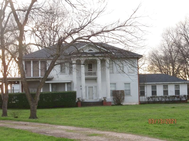
Killarney was built by James Stuart Douglas in 1920 and designed by Edward F. Neild, a prominent Shreveport architect in the firm C. E. Olschner Architect Assoc. This is one of the first homes designed by Mr. Neild. Mr. Douglas was a planter, civic . . . — — Map (db m175663) HM
On Dixie Shreveport Road (Louisiana Route 3049) at Cornhusker Road, on the right when traveling north on Dixie Shreveport Road.
The W.H. North Plantation dates back to 1886. The original home was moved with mules and wagons from the bank of Red River in 1903 to the present site on Cottonwood Bayou. After being destroyed by fire in 1923, the home was rebuilt on the original . . . — — Map (db m175850) HM
On Main Street north of 2nd Street, on the right when traveling north.
Just to the north of Herndon Middle Magnet School is one of the most historic regions in north Caddo Parish. During the early decades of the 19th century it was a crossroads of navigable bayous, a Caddo Indian Trail, an early road which settlers . . . — — Map (db m174348) HM
On Main Street north of 2nd Street, on the right when traveling north.
The village is named for R.L. "Bob” Gilliam who owned property from which he donated right-of-way for the T.S. & N. Railroad which ran from Texarkana to Shreveport. The understanding was that the railroad would establish a depot on the banks of Red . . . — — Map (db m174855) HM
On Adger Road at Piarce Lane, on the right when traveling east on Adger Road.
The first worship services in Gilliam were held in a railroad box car. In 1902 Gilliam Methodist Episcopal Church, South was built across Red Bayou north of the present church. That building was destroyed in the storm of 1908, along with all but one . . . — — Map (db m174465) HM
On Louisiana Route 3049, 0.5 miles south of Sherman Drive, on the left when traveling south.
The Justice Chapel Baptist Church was organized in 1894 under the leadership of Rev. C.J. Justice and Brother Willie Davenport and his wife. Other leaders in this early church were Rev. Eddie Moore, Brother Eddy Green, Brother Frank Cook, Mathis . . . — — Map (db m174630) HM
On Louisiana Route 3049 south of Sartor Road, on the left when traveling south.
Organized June 6, 1919, with 12 charter members, and named in honor of Mrs. Linda Lay who had been instrumental in the development of the spiritual life in the town. Constructed in 1920, dedication of the building was held on August 14, 1921. The . . . — — Map (db m174628) HM
On Adger Road east of Piarce Lane, on the right when traveling east.
The home was built circa 1910 by Reuben Douglas and his wife, Lucy Parsons, after the Gilliam 1908 storm destroyed their first home. Reuben, one of the early landowners in the area, purchased 800 acres in 1900, which he named All's Well Farm. Reuben . . . — — Map (db m174463) HM
On Main Street at 2nd Street, on the left when traveling south on Main Street.
Home of the Sunflower Festival and Red River Crossroads Museum
After R.L. Gilliam donated property in 1898 for the railroad depot, the area was officially founded and named Gilliam.
An article published in the Shreveport Times on . . . — — Map (db m174227) HM
On 1st Street, 0.1 miles west of Main Street, on the right when traveling east.
From the mid-1890's to the early 1970's the Texarkana, Shreveport & Natchez/Texas & Pacific Railroads served the economic and personal needs of northeast Caddo Parish along a roadbed at this site. While the railroad was being built during the 1890's . . . — — Map (db m174224) HM
On U.S. 71, 0.2 miles south of State Route 2, on the right when traveling north.
On June 23, 1912, twelve charter members organized the Hosston Methodist Church. At first they worshiped at the Baptist Church then in 1916 built a white wood frame church which faced east on this spot. In 1940 as the membership grew two porches . . . — — Map (db m173876) HM
On Parkway Drive north of Briar Rose Street, on the left when traveling north.
The Hosston Post Office was established on May 27, 1901. The first Hosston Postmaster was Dee R. Allen who served from May 27, 1901 - March 16, 1908, and the last Postmaster was Charles V. Giles who served from June 3, 1966 - December 31, 2004. The . . . — — Map (db m174037) HM
On U.S. 71, 0.1 miles north of Camellia Street, on the right when traveling north.
The house was built around 1878 and occupied by the William Adams family. James Patrick Fuller and his wife Gertie McKinney Fuller purchased the house in 1919. Their family included daughters Pattie Mae and Audrie, who was born in the house in 1920. . . . — — Map (db m244247) HM
On East Magnolia Lane near U.S. 71, on the right when traveling east.
Settlement in the Ida area began before 1840, with increasing numbers coming from the East after the Civil War. They came by ox-drawn wagons or by steamboat. Earliest permanent settlers were Readrick Kelly, Chesley Green Williams, the Munnerlyn . . . — — Map (db m173788) HM
On East Magnolia Lane east of U.S. 71, on the right when traveling east.
This building was erected in 1923 by W.C. Reynolds, an early Postmaster in Ida. It was the location for the Ida Post Office from 1923 until 1962. Following this period, the building was a carpenter shop of J.E. Richardson. In 1997 the building . . . — — Map (db m173786) HM
On Old Mansfield Road south of Keithville Lodge Road, on the right when traveling north.
Built 1903-04. Constructed by Tom Hudnall. Dedicated Oct. 16, 1904. Bell came from Teer family plantation, Coushatta, Louisiana. — — Map (db m176072) HM
On Louisiana Route 538 north of E Croom St, on the right when traveling south.
In 1914, as modes of transportation progressed, the Historic Caddo Lake Drawbridge at Mooringsport was built to replace the ferry. The Midland Bridge Company of Kansas City Missouri built the bridge under authority of the Caddo Parish Police Jury. . . . — — Map (db m205847) HM
On South Kerley Avenue at Savage Street, on the right on South Kerley Avenue.
Formally known as the town of Ananias, Oil City was founded as a whistle stop along the Kansas City Southern Railroad.
Early on, most settlers were fishermen, trappers, and farmers. Others took part in the timber industry, and another group . . . — — Map (db m170202) HM
On Williamson Parkway, 0.2 miles west of State Route 1, on the left when traveling west.
Before white men came to the area, North Caddo was the rich forestland of the Kadohadacho, or Caddo, Indians. In 1904, the first oil well in North Louisiana was drilled. The resulting "Oil Rush" brought hysteria to the once peaceful and serene . . . — — Map (db m169807) HM
On State Highway 1 at Williamson Parkway, on the right when traveling north on State Highway 1.
The world’s first over water oil well was completed in Caddo Lake in 1911. The Ferry Lake No. 1 was erected by Gulf Refining Co. The well bottomed at 2,185 feet and produced 450 barrels per day. — — Map (db m87158) HM
On Williamson Parkway west of State Highway 1, on the left when traveling west.
Blues singer from Mooringsport, La. (1888-1949). He played 12 string guitar on Shreveport’s Fannin St., sang his way out of prison, and became a folk hero with songs like “Goodnight Irene,” “Bourgeois Blues,” and “Midnight Special.” — — Map (db m139521) HM
Near S. Land Avenue, 0.1 miles north of Savage Street, on the right when traveling north.
In the early 1900's this was a small logging community known as Ananies. In 1906, the first discovery oil well in the field, the Savage No. 1, was brought in. Around 1908 the name of the town was changed to Oil City, by 1910 the population had . . . — — Map (db m87161) HM
On South Land Avenue, 0.1 miles south of Savage Street, on the left when traveling north.
Built 1910 at Trees, Louisiana. Moved to present site in 1983. Both Trees and Oil City are intimately associated with the oil boom of the early 1900s. Trees City was founded in 1909 by Trees Oil Company. Listed in National Register of Historic . . . — — Map (db m169898) HM
On West Front Street (State Highway 1) north of Main Street (State Highway 168), on the left when traveling north.
United Gas Public Service Company, discovered the Rodessa Oil Field one mile west of this historical marker on July 7, 1935. Rodessa was a “Boom Town” a few weeks later.
United’s L.L. Young No. 1, Lease 6875, Sec.21-23N-16W Rodessa Field Caddo . . . — — Map (db m128263) HM
On West Front Street (State Highway 1) 0.2 miles north of Main Street (State Highway 168), on the right when traveling north.
Frog Level and Rodessa
A town meeting was called in the 1800’s by Noah Tyson Sr., store owner, police juror and post master, to name their town. The frogs were hollering in a nearby pond. A man from Alabama jumped up and said, “Let’s name . . . — — Map (db m128259) HM
On Dixie Shreveport Road (Route 3049) at Cash Point Plantation Road, on the right when traveling north on Dixie Shreveport Road.
Typical of the large river plantation of the mid-nineteenth century, the 1,647 acres were located on both the Caddo and Bossier sides of the Red River. Beginning in 1839, Cash Point Plantation was successively owned by several large land owners of . . . — — Map (db m175958) HM
On Dixie Shreveport Road (Louisiana Route 3049) 0.5 miles north of Whitefield Circle, on the right when traveling north.
The former Rosenwald School at Cash Point was built in 1923-24 for a cost of $2,300.00 as a two teacher frame school. The Rosenwald Fund was developed by Julius Rosenwald, CEO of Sears, Roebuck & Company, and educator, Booker T. Washington in . . . — — Map (db m175959) HM
On Dixie Shreveport Road (Louisiana Route 3049) 1 mile north of Cash Point Plantation Road, on the right when traveling north.
Three historic plantations, Cash Point, Gold Point, and Buckhall Plantations, date back to 1839, when they were purchased by James Belton Pickett, Paulina de Graffenried, and James Blair Gilmer. The Buckhall portion on the north and east side was . . . — — Map (db m175957) HM
On Dixie Shreveport Road (Louisiana Route 3049) at Sentell Road, on the right when traveling north on Dixie Shreveport Road.
The first cotton gin on this site was built by John M. Sentell circa 1895. It was a wooden structure painted red and known as The Red Gin. It burned and was replaced by the current structure circa 1933. In 1953 Lowry and Wash Sentell modernized the . . . — — Map (db m175852) HM
On Dixie Shreveport Road (State Highway 3049) 0.2 miles north of Moon Lake Farm Road, on the right when traveling north.
The largest ceremonial center of the Caddo Indians in Louisiana, this site originally included seven mounds arranged around a large plaza. The Caddo Indians lived at this site between 900 and 1200 A.D. — — Map (db m175851) HM
On Dixie Shreveport Road (Louisiana Route 3049) 1 mile south of Sentell Road, on the left when traveling north.
One of the many properties acquired by James Belton Pickett in the period following the succession of the Caddo Indian lands to the United States, c. 1837. Pickett, of South Carolina, came to this area c. 1836. He became one of the founders of . . . — — Map (db m175853) HM
On Dixie Shreveport Road (Louisiana Route 3049) 1 mile north of Cash Point Plantation Road, on the right when traveling north.
In 1899, the large landholdings of James Pickett, one of the founders of Shreveport, began a series of ownership changes. In 1912, Samuel S. Pittman and his wife, Pattie, purchased land in Section 14, formerly held by James Pickett. The house, built . . . — — Map (db m175956) HM
On Garden Street near South Peirre Avenue, on the right when traveling east.
At this location, on Sept. 4, 1925, the most disatrous [sic] fire in Shreveport's history erupted when a hot water heater exploded. Although Fire Station No. 4 was located across the street, a broken water main rendered it helpless to fight . . . — — Map (db m142907) HM
Near Texas Avenue north of Lawrence Street, on the right when traveling north. Reported missing.
1057 Texas Avenue founded in 1866. Oldest Black Baptist Church in Shreveport. Built Present location in 1903. Romanesque Revival Style, by noted Architect N. S. Allen — — Map (db m180320) HM
On Austin Place south of Milan Street, on the right when traveling south.
752, The Hauser House, built 1867, remodelled c.1880. 754-56, The Cooke House, built c.1870. 758, The Dalzell House, built c.1870, was once rectory of St. Mark's Episcopal Church. Austin Place was originally known as Christian Street. — — Map (db m140833) HM
On Cotton Street east of U.S. 79/80, on the right when traveling east.
Conducted First Episcopal Service in Shreveport March 24, 1839. St. Paul's Church Formed 1845. Renamed Grace Church 1851. Renamed St. Mark's 1859. St. Mark's Relocated 1954. Holy Cross Organized 1954. — — Map (db m139948) HM
On Texas Street (U.S. 80/79) west of Austin Place, on the right when traveling east.
Built 1923 by the Court of Calanthe, an early African-American woman's organization. Served as the Court of Calanthe's headquarters for many years as well as housing the offices of Black professionals. Roof Garden at top of building was used for . . . — — Map (db m141014) HM
On Weinstock Street west of Pierre Avenue, on the left when traveling west.
Built 1917 as Central Colored High School. Later a Junior High School and today an Elementary School. Listed in National Register of Historic Places, 1991. — — Map (db m142859) HM
On Austin Place south of Milam Street, on the right when traveling south.
Built c.1883 at corner of Christian and Jewell Streets, opposite Oakland Cemetery. Moved from that site in 1976. Important example of Queen Anne cottage architecture. — — Map (db m140480) HM
On Grand Avenue near Milam Street, on the right when traveling north.
"Ladies and gentlemen, you've never heard of this young man before, but one day you'll be able to tell your children that you heard musical history made tonight." With these prophetic words Elvis Presley was introduced to the country from . . . — — Map (db m141033) HM
On Sprague Street, 0.3 miles west of Douglas Street, on the left when traveling west.
The Hebrew Benevolent Assn. of Shreveport purchased a quarter acre of Oakland Cemetery from the city in July, 1858. The resulting Jewish cemetery was Shreveport's first and Louisiana's fifth. This cemetery was used exclusively from 1858-1886 and . . . — — Map (db m139944) HM
On Common Street at Texas Street (U.S. 79/80), on the right when traveling south on Common Street.
First United Methodist Church operated as a station church on the Greenwood-Shreveport Circuit from the 1830s and established its first building in 1845 on Market Street between Travis and Fannin. The congregation moved to this location at the "Head . . . — — Map (db m109769) HM
On Grand Avenue north of Texas Avenue (U.S. 79/80), on the right when traveling north.
Guitar lovers worldwide know the name of "James Burton." Burton's distinctive style has rightfully earned the Shreveport native a place in music history and endeared him to countless musicians. His service for studio recording and live performances . . . — — Map (db m141710) HM
On Austin Place south of Milam Street, on the left when traveling south.
Built 1897 by L.R. Logan, beer and ice manufacturer. Designed by architect Nathaniel Sykes Allen. One of the finest remaining Queen Anne Victorian houses in the city. — — Map (db m140477) HM
On North Common Street, 0.5 miles north of Caddo Street.
Built 1887 as city's first waterworks. Contains original equipment in working order. Only example of its sort remaining in the United States of America, according to Smithsonian Institution. Declared a National Landmark in 1982. — — Map (db m140206) HM
Oakland Cemetery, the oldest cemetery
in Shreveport, appeared in the film Mr. Brooks
starring Kevin Costner and Dane Cook. In
addition to citizens of the community, the
cermetery holds approximately 800 people who
died during the yellow fever . . . — — Map (db m141016) HM
Earliest tombstone dated 1842. Cemetery officially opened in 1847. At least 16 mayors are buried here as well as some 1,000 Confederate veterans & soldiers. Fence and walls erected 1905, the same year it began to be officially called "Oakland," . . . — — Map (db m140562) HM
When Shreveport was first laid out in 1836, the need for a cemetery was among the first considerations of the Shreve Town Company. The first cemetery was known as the Fannin Street Cemetery. Its use began almost as soon as the town came into being. . . . — — Map (db m142908) HM
On Cotton Street, on the left when traveling north.
Designed by Edward Neild and Clarence Olschner with interior design work by Paul Heerwagen. Built in 1914. Housed B’nai Zion Synagogue -- founded 1859 -- from 1915 to 1956. Ten stained glass windows are by Lafarge. Listed in National Register of . . . — — Map (db m214289) HM
On Austin Place south of Milam Street, on the right when traveling south.
Designed by architect Luther T. McNabb. Built 1896 for grocer W.B. Olgilvie. Later residence of Samuel. G. Wiener, Sr. family. Noted architects Samuel G. Wiener, Jr. and William B. Wiener, Sr. were brought up in this house. — — Map (db m140478) HM
On Sprague Street at Christian Street, on the right when traveling west on Sprague Street.
Group of six Victorian cottages built circa 1890. Possibly remodellings of circa 1870 houses known to have stood on same site. Listed in National Register of Historic Places, 1983. — — Map (db m140460) HM
On Pierre Avenue south of Looney Street, on the right when traveling north.
Founded 1865. Previous St. Paul's church building built 1889 and located on Caddo Street in the low lying area to it which gave it's name: St. Paul's Bottoms. Present Gothic Revival style building constructed 1926. — — Map (db m142881) HM
On Texas Avenue (U.S. 79/80) near Crockett Street, on the right when traveling west.
Preserved commercial block dating from between 1899 and 1917. Many early ethnic businesses were housed here, including Black, Jewish, Chinese and Arab merchants. Collectively listed in the National Register of Historic Places in 1979 as the Texas . . . — — Map (db m139950) HM
On Cotton Street east of Texas Street (Highway 79/80), on the right when traveling east.
In 1904, the oldest religious body in Shreveport, St. Mark's Episcopal Church, began building this cathedral. Then in 1954, St. Mark's decided to move to a more suburban setting; there was a select group of members that remained behind and founded . . . — — Map (db m139949) HM
On Texas Avenue (U.S. 79/80) at Murphy Street, on the right when traveling south on Texas Avenue.
This Marks the Site
of
Battery 7
One of the eighteen batteries
and four forts which formed
the Confederate defenses
of Shreveport
1864 – 1865 — — Map (db m138784) HM
On Youree Drive (State Highway 1) at Ockley Drive on Youree Drive.
Built as Broadmoor School in 1929. Renamed in memory of Albert Coldwell Steere (1879-1930), influential businessman, philanthropist and real estate developer, and creator of Broadmoor area. Expanded 1938. Listed in National Register of Historic . . . — — Map (db m143801) HM
On Forest Avenue at Wheeless Avenue, on the left when traveling west on Forest Avenue.
Built in 1924 for Huey P. Long, Governor of Louisiana 1928-1932. Long's initials "H.P.L." are incorporated into the cast iron balcony above the front entrance. Listed in National Register of Historic Places, 1991. — — Map (db m143720) HM
On Line Avenue south of Kings Highway, on the right when traveling north.
Built 1925 as New Shreveport High School. Re-named 1926 in memory of prominent local educator Dr. Clifton Ellis Byrd, who laid the building's cornerstone. Listed in National Register of Historic Places, 1991. — — Map (db m143741) HM
On Ockley Drive east of College Lane, on the right when traveling east.
Private liberal arts junior college for girls, 1927-1942. Founded by Dr. M.E. Dodd, Pastor, First Baptist Church, Shreveport. Two original buildings now part of First Baptist Church. President's Home located at 601 Ockley Drive. — — Map (db m140561) HM
On Ockley Drive at College Lane, on the right when traveling east on Ockley Drive.
Now called "Medjoy". Built 1929 as Dodd College President's Residence. Dodd College, named for its founder Dr. M.E. Dodd, operated 1926-1942. This house was Dr. Dodd's residence for many years, Listed in the National Register of Historic Places, . . . — — Map (db m143799) HM
On Samford Avenue at Kings Highway, on the right when traveling south on Samford Avenue.
On this site a dedicated group of men from the Shriners International Fraternity began the legacy of providing free healthcare services to children by opening the world's First Shriners Hospital on September 16th, 1922.This plaque placed . . . — — Map (db m139908) HM
On Fairfield Avenue near Kings Highway when traveling north.
Built 1921 by lumber and railroad executive Randle T. Moore. Moore was also chairman of the board of Commercial National Bank of Shreveport in the 1920's and a trustee and major benefactor of Centenary College. House designed by Shreveport . . . — — Map (db m143714) HM
On Line Avenue near Oneonta Street, on the right when traveling north.
Built in 1928. Designed in Bavarian Gothic style to blend with residential character of neighborhood. Listed in National Register of Historic Places, 1991. — — Map (db m143800) HM
On St. Vincent Street south of West 74th Street, on the right when traveling south.
Dating from the 1840s, this was once the family burial grounds of the Pickens family, planters, of Caddo Parish. Among those buried here is Israel Wilson Pickens, Caddo Parish Sheriff from 1862-1865, during which time Shreveport was Confederate . . . — — Map (db m140205) HM
On Fairfield Avenue at Kings Highway, on the right when traveling south on Fairfield Avenue.
Built 1923-25. Designed by Maritz and Young, architects, of St. Louis, Missouri. Considered one of the city's most important examples of Tudor Revival style architecture. — — Map (db m143719) HM
On Market Street (U.S. 71) at Crockett Street, on the left when traveling south on Market Street.
Parish Judge Washington Jenkins, on Nov. 4, 1840, sold his 2-story frame house to Caddo Parish for a courthouse. A jail replaced the kitchen. Courthouse was sold at foreclosure in 1855 at its own door. — — Map (db m138770) HM
On Texas Street (State Highway 79/80) east of McNeill Street, on the right when traveling east.
When the Caddo Parish Courthouse was built in 1926 it was the third one erected on this same plot of land and cost $1,2500,000. At the time of its dedication on April 21, 1928 it was debt free, paid for by taxpayers with a five year . . . — — Map (db m139869) HM
On Texas Street (U.S. 79/80) at Marshall Street, on the right when traveling east on Texas Street.
Third Courthouse to occupy site since 1860. First Courthouse on site served as Louisiana's Confederate Statehouse during Civil War. Present Courthouse designed by Neild & Somdal architectural firm. Built 1926-28. Served as model for numerous other . . . — — Map (db m109764) HM
Near Texas Street (U.S. 80) at North Spring Street (U.S. 79).
Near this site stood the trading post of James H. Cane and William S. Bennett. The first business building in what later became Shreveport. Built before 1852 at this place, then known as Cane & Bennett's Bluff, it was for many years the center of . . . — — Map (db m109745) HM
Built 1910 for Arkansas-St. Louis-Southwestern Railroad. Only surviving passenger railroad terminal in city built prior to WWI. Listed in National Register of Historic Places, 1991. — — Map (db m109775) HM
On Edwards Street south of Travis Street, on the left when traveling north.
Built 1922, under the administration of Mayor John McWilliams Ford, to house Shreve Memorial Library. Designed by J. P. Annan in style of Roman Villa. Remained in use as central public library for over half a century. — — Map (db m139538) HM
On Edwards Street north of Texas Avenue (U.S. 79/80), on the left when traveling north.
Built 1922, under the administration of Mayor John McWilliams Ford to house Shreve Memorial Library. Designed by J. P. Annan in style of Roman Villa. Remained in use as Central Public Library for over half a century. — — Map (db m139864) HM
On Texas Street (U.S. 79/80) at Edwards Street, on the right when traveling east on Texas Street.
Built 1940. Designed by architects McKim, Mead and White of New York City in association with Samuel G. Wiener of Shreveport. Interior lobby contains original murals depicting history of Shreveport. Vault originally made for Bank of Tokyo; WWII . . . — — Map (db m109749) HM
On Market Street (U.S. 71) at Texas Street (U.S. 79/80), on the right when traveling north on Market Street.
In 1836 Market Street was designated the site of the city market. From 1850 to 1872 the Market House was located in the middle of Market Street from Texas Street north to the alley. On October 4, 1890 Shreveport's electric streetcar service, the . . . — — Map (db m109761) HM
On Commerce Street at Lake Street on Commerce Street.
912 Commerce Street, 80 feet south of this corner, site of the Benjamin L. Hodge home, where Gen. Smith lived 1863–65 while Commander of Trans-Miss. Dept. CSA. Built 1848, demolished 1960. Originally home of La. Supreme Court Judge Thomas T. . . . — — Map (db m115450) HM
Possibly named for John Grange Green, pioneer Shreveport property owner and friend of Capt. Shreve, or for Dr. William Mercer Green, who was killed in a duel in this alley, just north of Texas Street, in 1849. South of Texas St. the alley is called . . . — — Map (db m109743) HM
Built by Martin Tally about 1865. Known as the Smith Building from 1870. Extensively remodelled 1897. Served as first Federal Courthouse of Shreveport 1881-1887. Later home to Eliott Electric Company and Harrison Tobacco Company. — — Map (db m109772) HM
On Clyde Fant Parkway south of Milam Street, on the right when traveling south.
This marks the site of the former home of Henry Watkins Allen Civil War Governor of Louisiana. 1864-1865
Also the site of Battery 10 one of the eighteen batteries and four forts which formed the Confederate defenses of Shreveport. . . . — — Map (db m178309) HM
On Marshall Street at Fannin Street, on the left when traveling south on Marshall Street.
Established in 1856, Holy Trinity was moved to this site in 1858. Five of its priests lost their lives treating the victims of the Yellow Fever Epidemic of 1873. The present church, in Romanesque Revival style, was built in 1896. — — Map (db m168349) HM
On Texas Street (U.S. 79/80) at Marshall Street, on the right when traveling west on Texas Street.
Built 1910 to house Hutchinson Bros. Department Store. Has exceptional terra cotta detaining on front. Original plans called for a four story building, but was increased to six by contractor, who failed to meet deadline for completion. — — Map (db m109767) HM
On Louisiana Avenue, 0.3 miles north of Fairfield Avenue.
Built 1922 as a railroad hotel-- Union Depot stood across the street for many years. Extensively restored and remodelled in 1980s. Listed in National Register of Historic Places, 1989. — — Map (db m139874) HM
On Texas Street (U.S. 79/80) at Common Street, on the right when traveling east on Texas Street.
Opened in 1895, Justin Gras Grocery and Liquor here once stood as Shreveport's largest retail grocery business. Famous for saying "What is good for Shreveport is good for me," Gras gave to numerous causes, including a $2.3 million endowment to . . . — — Map (db m109770) HM
On Texas Street (U.S. 79/80) at Market Street (U.S. 71), on the right when traveling west on Texas Street.
Built 1910 to house Commercial National Bank. Designed by architect firm of Stern & Mann of Little Rock, Ark. Tallest building in city when completed in 1911. Listed on National Register of Historic Places , 1982. — — Map (db m109751) HM
On Cotton Street west of Mc Neil Street, on the right when traveling west.
Built 1924 to house Police department and City Court. Excellent example of early 20th century Neo-Classic/Federal architecture. Listed in National Register of Historic Places, 1982. — — Map (db m139543) HM
On Common Street (Louisiana Route 3036) at Cotton Street, on the right when traveling north on Common Street.
Designed by local architect Edward Neild who was an active member of the Shreveport Scottish Rite. It was built 1917. Listed in the National Register of Historic Places in 1986. — — Map (db m139902) HM
On Texas Street (U.S. 79/80) at Marshall Street, on the right when traveling west on Texas Street.
Built 1911 as Federal Court House and Post Office, expanded in 1931. Remained in use as federal Building until 1972. Has housed Shreve Memorial Library's central branch since 1970s. Listed in National Register of Historic Places, 1974, when interior . . . — — Map (db m109763) HM
On Commerce Street at Texas Street, on the right when traveling south on Commerce Street.
100 block of Texas. Preserved block of early Shreveport commercial buildings, most dating from between 1860 and 1900. Excellent examples of 1880s-1890s cast iron found on many. Texas Street Bridge, which bisects block, was dedicated October, 1933 by . . . — — Map (db m109741) HM
Near Market Street at Texas Street (U.S. 79), on the right when traveling south. Reported missing.
In 1845 three of Shreveport’s first churches were organized within a four block span of Market Street: First Baptist at Travis and Market, SE; First Presbyterian, 600 block of Market, west side; and First United Methodist at Market and Fanning, SW. . . . — — Map (db m180325) HM
On Crockett Street east of Louisiana Avenue, on the left when traveling east.
In October of 1923, construction began on a 2,500 seat opera house and movie theater that would become known as The Strand. It was funded by the Saenger Brothers and the Ehrlich Brothers who went on to own 320 theaters throughout the south. Of all . . . — — Map (db m139605) HM
On Louisiana Avenue south of Milam Street, on the left when traveling south.
Built 1925 for Saenger-Ehrlich Theatre Enterprises. Designed by architects Emile Weil and Charles G. Davis of New Orleans. Interior designed by Paul Heerwagen of Arkansas. Was flagship theatre of Saenger Amusement Co., a forerunner of Paramount. . . . — — Map (db m139906) HM
On Edwards Street north of Texas Street (U.S. 79/80), on the left when traveling north.
The building here at 400 Edwards Street, was originally constructed to house the Shreveport Memorial Library. It opened in 1925 and remained at this location until 1980. After two years of renovations, the Shreveport Chamber of Commerce took over . . . — — Map (db m139862) HM
On Texas Street (Highway 79/80) at Edwards Street, on the right when traveling west on Texas Street.
In 1870, three blocks northeast of this site, water well drillers discovered the first natural gas field in northwest Louisiana. An ice plant located near the site was the first to utilize this new resource.
The area's first commercial . . . — — Map (db m109762) HM
On Common Street (Louisiana Route 3036) at Cotton Street, on the right when traveling north on Common Street.
The land the Scottish Rite Temple was purchased for $17,000 on September 16, 1913. The building measures approximately 133 feet by 111 feet and surprisingly, only cost $186,477.28 to construct. It houses a three-story theater, library, and kitchen . . . — — Map (db m139903) HM
On North Market Street north of Airport Drive, in the median.
One block west near mouth of Cross Bayou at Red River the ironclad Missouri and ram Webb built. Missouri armored with railroad iron, In 1863 Webb fought U.S.S. Indianola near Vicksburg. Missouri was surrendered . . . — — Map (db m139539) HM
On North Market Street (U.S. 71) near Airport Drive, on the right when traveling south.
One of Shreveport's most historic waterways, Cross Bayou is spanned by the old KCS Railroad Bridge, one of only two surviving examples of the Waddell A-Truss bridge design in America. On the south bank of Cross Bayou was the Confederate Navy Yard . . . — — Map (db m139540) HM
On North Market Street (U.S. 71), on the right when traveling south.
In 1870, natural gas and water gushed
from a 961 ft. water well drilled
near this spot by American Well Works
for Shreveport Ice Mfg. Co. The
gas was used to light the plant
and is the first documented
commercial use of natural
gas in . . . — — Map (db m202806) HM
3141 entries matched your criteria. Entries 301 through 400 are listed above. ⊲ Previous 100 — Next 100 ⊳