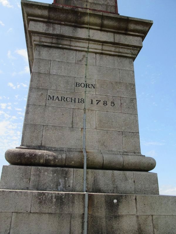
On Barn Lane at Robartes Road, on the right when traveling east on Barn Lane.
Walter Raleigh Gilbert
Born
March 18 1785
Died
10 May 1855
To the Memory of
Sir Walter Raleigh Gilbert.
Lieutenant General in the Bengal Army
who, after sharing as a Subaltern
in the campaigns of 1803 and 1804 under Lord Lake . . . — — Map (db m124240) HM WM
On St Nicholas Street (England Route B3268) close to Castle Canyke Road, on the right when traveling north.
In 1859, because of the aggressive foreign policy pursued by Napoleon III, Britain felt herself under threat of invasion by France. This keep was built in that year, on land donated by the Town of Bodmin, as a militia stores, designed to hold . . . — — Map (db m124237) HM
On St Nicholas Street (England Route B3268) at Castle Canyke Road, on the right when traveling north on St Nicholas Street.
Erected
By the DCLI
To Their
Glorious Dead
255 Officers
4027 Other Ranks
1914 — 1919
I
France & Flanders 1914 – 1917
Italy 1917 – 1918
France & Flanders 1918 – 1919
VI
France & Flanders 1915 – . . . — — Map (db m124233) HM WM
On St Nicholas Street (England Route B3268) at Castle Canyke Road, on the right when traveling north on St Nicholas Street.
The Royal Air Force Linguists’ Association 2004
RAFLing Association
JSSL
Between 1951 and 1956, the Joint Services School for Linguists was located at Walker Lines, Bodmin. Here Linguists were trained for covert work, their vigilance . . . — — Map (db m124239) HM
On Turf Street at Honey Street, on the left when traveling north on Turf Street.
On or Near This Spot
Stood the House
in which
Sir Arthur Quiller Couch House
Renowned
In All the World
As a Freeman of the
Borough of Bodmin
Was Born on the 21st
November 1863.
21st November 1963.
( lower plaque )
This . . . — — Map (db m155012) HM
On Fore Street close to Turf Street, on the left when traveling north.
The Trafalgar Way
Bodmin – 3rd Post-Horse Change
On Monday, 21st October 1805 the Royal Navy decisively defeated the Combined Fleet of France and Spain off Cape Trafalgar south of Cadiz. This victory permanently removed the . . . — — Map (db m122160) HM
On St Nicholas Street (England Route B3268) at Castle Canyke Road, on the right when traveling north on St Nicholas Street.
In honor of the Hallowed
Memory of the 3533 Men of the
29th Division. United States Army
Killed in Battle from 6 June 1944
To Victory in Europe 8 May 1945
In October 1942 the 29th Infantry Divison Composed of
National Guard Units from . . . — — Map (db m124236) HM WM
Occupying an elevated position on a prominent ridge and surrounded by a loop of the River Tamar, you are standing in a rich archaeological landscape that has seen human occupation for at least four thousand years.
In 2007 archaeologists from . . . — — Map (db m273687) HM
Near Avenue Road at Campbeltown Way, on the right when traveling north.
Welcome to the Discovery Quay
From the quayside and the National Maritime Museum Cornwall (NMMC), there are fine vistas of the harbour with Falmouth's historic fabric of tiered harbourside properties dominating the waterfront.
The Port . . . — — Map (db m124016) HM
On Pendennis Rise 0.2 kilometers south of Castle Drive, on the right when traveling south.
Welcome to Falmouth Docks
The port of Falmouth’s greatest asset is its deep and sheltered harbour. Amny mariners throughout the centuries have long regarded Falmouth as the “First and Last Port” for ships crossing the Atlantic . . . — — Map (db m124042) HM
Near Avenue Road at Campbeltown Way, on the right when traveling north.
Coastal Forces of World War II
HMS Forte IV
This plaque commemorates the men and women of Allied Coastal Forces who served with the Royal Navy at HMS Forte IV at Falmouth between 1941 and 1946. At HMS Forte IV Motor Torpedo Boats, Motor Gunboats . . . — — Map (db m124014) WM
On Avenue Road at Campbeltown Way, on the right when traveling north on Avenue Road.
The granite pyramid was erected in 1737 by Martin Lister Killigrew the owner of Arwenack. He never stated specifically the purpose of it, but many have assumed it to be a memorial to the Killigrew family.
The Killigrew Family
The Killigrew s . . . — — Map (db m124012) HM
Near Avenue Road at Campbeltown Way, on the right when traveling north.
This stone commemorates the start of work on the National Maritime Museum Cornwall in the presence of HRH The Duke of Edinburgh twenty-seventh of July nineteen ninety-nine — — Map (db m124017) HM
Near Castle Drive 0.8 kilometers south of Cliff Road, on the left when traveling south.
Welcome to Pendennis Point
Black Rock and St Anthony's Lighthouse
Black Rock, the isolated rock located in the entrance to Falmouth Harbour, roughly divides it into two distinct channels: the eastern deep-water channel and the western . . . — — Map (db m124043) HM
Near Avenue Road at Campbeltown Way, on the right when traveling north.
Early in the 17th century, according to local legend, Sir Walter Raleigh pointed out to Sir John Killigrew of Arwenack that Falmouth was the ideal site for a port to handle sailing ships. In 1611 John Speed wrote “Falmouth is so copious, . . . — — Map (db m124018) HM
On Castle Drive 0.8 kilometers south of Cliff Road, on the right when traveling south.
There have been defences on this point since 1539, when Henry Ill built a blockhouse known as 'Little Dennis' to protect the estuary from enemy warships.
The blockhouse was equipped with heavy guns. You can see three gun openings at ground level . . . — — Map (db m124044) HM
Near Western Road close to Dockey, on the left when traveling north.
George Fox 1624 – 1691 was imprisoned in this castle in 1656, for eight months. With other Quakers he suffered under unspeakable conditions in Dooms-Dale
“There was never under any imprisonment that I was in but it was for the . . . — — Map (db m124010) HM
On Broad Street at High Street, on the left when traveling north on Broad Street.
To the
Immortal Honour
of
Those from this Town
who gave their Lives
for King & Country
in the Great Wars
1914-1918
1939-1945
W.H. Adams · S. Bartlett · D.B. Bennett · T. Bennett · C. Bickle · G.T. Brendon · A.J. Brent · J. . . . — — Map (db m124177) WM
Near Western Road at Dockey, on the left when traveling north.
Moote Hall
c.13th century
The castle, a symbol of law and order
was used as a centre of justice.
This building was used by the assizes
(travelling courts) and also for
administrative purposes. — — Map (db m124128) HM
Near Western Road at Dockey, on the left when traveling north.
This was the main entrance into the castle from the town until the late 12th century.
Originally, there was a deep ditch around the castle crossed by a fortified bridge. This was destroyed when nearby Eagle House was built in the 18th century. . . . — — Map (db m124009) HM
Near Western Road at Dockey, on the left when traveling north.
Shell Keep
c.12th century
This circular stone wall had a wall walk on the top designed principally for use as a fighting platform. The High Tower was built inside this wall in the13th century and the gap spanned with a platform. (Note the joist . . . — — Map (db m124180) HM
Near Western Road at Dockey, on the left when traveling north.
In the Middle Ages this gatehouse led out to the Earl's private deer park. The entrance passage continued out across the castle ditch, over a fortified bridge to where the Guildhall now stands.
Four square holes for the timber decking can be . . . — — Map (db m124176) HM
Near Western Road at Dockey, on the left when traveling north.
Throughout the Middle Ages the courtyard was packed full of buildings providing accommodation for the Lord and his followers.
There were also service buildings: a survey carried out in 1337 lists a chapel, stable, gaol, hall and various . . . — — Map (db m124126) HM
Near Western Road at Dockey, on the left when traveling north.
The development of the Castle
The first castle was built in the years immediately after the Norman Conquest — a military outpost in hostile country.
The original timber defences were gradually replaced in stone and by the 12th century . . . — — Map (db m124178) HM
On Western Road at Dockey, on the left when traveling north on Western Road.
The Earl's Chamber
You are standing in the lobby which led into the Earl's chamber in front of you.
Behind you another door led out onto the flat roof which, in the 13th century, covered the space between the high tower and surrounding walls. . . . — — Map (db m124203) HM
On Western Road at Dockey, on the left when traveling north on Western Road.
The Gate
There was a strongly defended gate here in the 13th century. The slot for the portcullis and the deep socket for the stout timber beams which secured the door can be seen in the wall behind you.
To your right, steps within the . . . — — Map (db m124206) HM
Near Western Road at Dockey, on the left when traveling north.
The Keep
In the 13th century, the building high on the mound in front of you provided a lordly reception suite where the Earl could entertain on special occasions.
The approach was deliberately formal and designed to impress. Anyone wishing . . . — — Map (db m124179) HM
Near Western Road close to Dockey, on the left when traveling north.
The Landscape
From the top of this high tower it is easy to see why the Normans built their castle here at Launceston. Not only does the castle dominate the surrounding countryside but it also controlled the main road into Cornwall at the . . . — — Map (db m124205) HM
On Broad Street at Westgate Street, on the left when traveling west on Broad Street.
The Trafalgar Way
Launceston - 4th Post-Horse Change
On Monday, 21st October 1805 the Royal Navy decisively defeated the Combined Fleet of France and Spain off Cape Trafalgar south of Cadiz. This victory permanently removed the threat . . . — — Map (db m122161) HM
Remembering Austrian Jewish Artist
Albert Reuss
and his devoted wife
Rosa nee Feinstein
who fled Vienna to England in 1938
to escape the Nazi Holocaust.
They moved to Mousehole in 1948.
Because of Rosa's love . . . — — Map (db m206534) HM WM
Celebrated as one of the very best examples of a pre-war lido in the world, the Grade II listed Jubilee Pool was originally opened in May 1935 and is now a rare survivor.
Built on a traditional bathing spot near the harbour, it was designed by . . . — — Map (db m273711) HM
On Battery Road, on the right when traveling east.
Remember
In honour and gratitude
Those brave men of Penzance
Who gave their lives to
Their country's cause and
Fell in the Great War
of 1914-1918
(names not transcribed) — — Map (db m279988) WM
In Memory of Private Richard Masters, Royal Marines 1784 – 1805 of Loskeyle in this parish who served on board HMS Thunderer and was killed in action at the Battle of Trafalgar 21st October 1805, aged 21
“No grave but the sea” — — Map (db m285434) HM
Near this spot was the grave of the Rashleigh family and on March 15th 1823 Charles Rashleigh was laid to rest here beside his wife Grace, née Tremayne, who had died in 1820. The tomb above the grave was demolished when a chapel was erected for . . . — — Map (db m273695) HM
On Church Street, on the right when traveling east.
Former home of Charles Rashleigh (born 1747), local entrepreneur and founder of Charlestown. Bought by Walter Hicks & Co Ltd, founders of St Austell Brewery. — — Map (db m273693) HM
On Unnamed Road 0.2 kilometers north of St Breward Village Hall, on the left when traveling north.
We Must Not Forget
We Must Always Remember
WWI 1914 – 1918
L/Sgt Francis S Armstrong · L/Cpl William H Arthur · Pte George Bunt · Pte Frederick W Chidley · Pte Frederick C Cottell · PO John Drew · Sgt Frank Ebbett · Sapper James H Gill · . . . — — Map (db m124241) WM
The decline of the mining and fishing industries at the beginning of the 20th century coincided with the start of St Ives' first steps on the road to becoming today's internationally-famous arts colony with the founding of the St Ives Arts Club in . . . — — Map (db m274325) HM
Artist reflecting real life events in the seafaring community -- the wreck of the Alba (1938) and loss of the St Ives lifeboat shown by Alfred Wallis and photo. In each case the lifeboats were destroyed -- Caroline Parsons in 1908 and John and Sarah . . . — — Map (db m273994) HM
In Proud and Grateful memory
of the men of St Ives
who in the World War 1939-1945 &
in the Great War 1914-1918
gave their all and in giving
raised Men's ideals of what
Man may become.
Their name liveth for evermore. — — Map (db m274328) WM
This ancient chapel of St Nicholas, which has stood upon this site from time immemorial, partially destroyed by order of the war office in 1904, was rebuilt and restored to its former condition by Sir Edward Hain, in 1911. Being the coronation year . . . — — Map (db m274327) HM
There has been a fishery in St Ives from Tudor times but the town's fishing heyday was between 1850-1900, with the last successful seine catch in 1905. The area from Market Place towards Porthmeor beach is the oldest part of St Ives and is known as . . . — — Map (db m273992) HM
Until at least the late prehistoric times, the Island was literally just that at high tides. Originally it was called 'Pendinnas' meaning 'St. Ia‘s fortified town' - and in the middle ages there was a cliff-castle fortress on the top meadow. . . . — — Map (db m273614) HM
Based on an early
16th century map of Mount's Bay
this mural was painted
for the filming of
"Twelfth Night
by Renaissance Films, 1995 — — Map (db m300827) HM
Near Castle Road 0.6 kilometers west of Atlantic Road, on the right when traveling west.
A Changing coastline
Arvor ow chanjya
Looking north-east, this spectacular view tells a story about the complex geology and changing shape of this north Cornwall coast.
The slates and siltstones that make up this coastline were . . . — — Map (db m124105) HM
Near Castle Road 0.6 kilometers west of Atlantic Road, on the right when traveling west.
Great Hall
A complicated ruin
Magor gomplek
The ruins in front of you are the remains of a series of successive halls and service buildings that once stood at the centre of the castle.
The original Great Hall was built in about 1230 and was . . . — — Map (db m124064) HM
Near Castle Road 0.6 kilometers west of Atlantic Road, on the right when traveling west.
Garden
A romantic retreat
Argel romansek
This walled garden was probably built in the 1230s and may have been part of a romantic literary landscape.
Gardening was taken up enthusiastically by English royalty in the 13th century. This . . . — — Map (db m124104) HM
Near Castle Road 0.6 kilometers west of Atlantic Road, on the right when traveling west.
Excavations and discoveries
Kowansow ha diskudhansow
This small hut was built for the site custodian shortly after excavations on the headland were completed in the 1930s.
These excavations, led by CA Ralegh Radford between 1933 and . . . — — Map (db m124107) HM
Near Castle Road 0.6 kilometers west of Atlantic Road, on the right when traveling west.
Florence’s shelter
Skovva Florence
Built in about 1900, this shelter provided welcome protection from the wind and rain for the ‘keeper of the keys’, Florence Nightingale Richards (b.1856).
Like her mother and grandmother before her, she . . . — — Map (db m124063) HM
Near Castle Road 0.6 kilometers west of Atlantic Road, on the right when traveling west.
Great Hall
Prince Dafydd's tale
Hwedhel Pennsevik Dafydd
It is a windy day in October 1242. Servants and tradesmen are busy bringing deliveries of food and barrels of wine, preparing for a feast.
You are standing in the island courtyard of . . . — — Map (db m124062) HM
Near Castle Road 0.6 kilometers west of Atlantic Road, on the right when traveling west.
The Haven
An Harber
The beach and headland at Tintagel appear to be wild and remote today, a haven for coastal plants and animals. But in the 19th century this area saw intensive use for mining, slate quarrying and fishing.
Beyond . . . — — Map (db m124110) HM
Near Castle Road 0.6 kilometers west of Atlantic Road, on the right when traveling west.
Dark Age Buildings
The northern ruins
An magoryow kledh
When this area was cleared by Ralegh Radford's workmen in the 1930s, they found the walls of several simple buildings. We do not know the date of these structures but they probably . . . — — Map (db m124068) HM
Near Castle Road 0.6 kilometers west of Atlantic Road, on the right when traveling west.
Chapel
The Priest's tale
Hwedhel an Pronter
In the driving rain, the weary priest makes his way to the chapel, as he has done every day for years. Today, in November 1361, he resolves that he won't spend another winter on this lonely, . . . — — Map (db m124071) HM
Near Castle Road 0.6 kilometers west of Atlantic Road, on the right when traveling west.
Gatehouse Courtyard
The Sheriff's tale
Hwedhel an Mer
It is an autumn day in 1306. Thomas de la Hyde, sheriff and steward of Cornwall, is visiting the castle to check on the progress and costs of building repairs.
Arriving on horseback, . . . — — Map (db m124060) HM
Near Castle Road 0.6 kilometers west of Atlantic Road, on the right when traveling west.
Dark Age Buildings
The Trader's tale
Hwedhel an Gwikor
A wooden sailing ship, laden with goods from the Mediterranean, is being unloaded down at the deep harbour. There are shouts in unfamiliar languages as large jars are brought up the steep . . . — — Map (db m124065) HM
Near Castle Road 0.6 kilometers west of Atlantic Road, on the right when traveling west.
Tintagel village
Tre War Venydh
The village of Tintagel, once known as Trevena, has been enormously influenced by the presence of the castle since it was built in the 1230s.
The medieval village of Trevena was enhanced by Earl Richard who . . . — — Map (db m124066) HM
Near Castle Road 0.6 kilometers west of Atlantic Road, on the right when traveling west.
Tunnel
Kowfordh
This tunnel is puzzling. Marks on the inside show that it was cut with metal tools, perhaps enlarging a natural cave.
It could have been a food store for the castle or perhaps a mysterious garden feature. — — Map (db m124069) HM
Near Castle Road 0.6 kilometers west of Atlantic Road, on the right when traveling west.
Upper courtyard
Garth gwartha
Soon after this part of the castle was built, the sea-cliff to your right collapsed, taking part of the medieval wall with it. The new wall built to replace it included two latrines that projected over the . . . — — Map (db m124061) HM
Near Castle Road 0.6 kilometers west of Atlantic Road, on the right when traveling west.
Well
Puth
This well is 5.5m deep. It was probably built at the same time as the castle, in the 13th century.
It is fed from natural springs, which emerge across the island. These springs would have provided fresh water for both the Dark Age . . . — — Map (db m124070) HM
Near Castle Road 0.6 kilometers west of Atlantic Road, on the right when traveling west.
Tintagel Castle has long been connected with the mythical King Arthur and its history is entwined with legend. But what really happened here?
In the 5th and 6th centuries AD there was a large, high-status settlement on the headland. It was . . . — — Map (db m124109) HM
On Boscawen Street at Prince’s Street, on the right when traveling east on Boscawen Street.
In Memory of Those Who Fell
In the Great Wars of
1914 – 1919 & 1939 – 1945
Falkland Islands 1982
Palmer, Andrew
Afghanistan 2009
Olaf S.G. Schmid — — Map (db m124046) WM
Near England Route B3276 817.6 kilometers north of Henver Road, Newquay, on the left when traveling north.
Welcome Dynnargh
Since Victorian times, this has been one of the most popular destinations on the Cornish coast. The cliff tops at Carnewas are famed for spectacular views of the giant rock stacks known as Bedruthan Steps marching away into the . . . — — Map (db m124048) HM
On un-named road, on the right when traveling south.
R · A · F St Eval
1939 – 1959
In Memory
of those who served and
the 974 gallant airrew
who lost their lives
Also the 22 Airmen and WAAFS
who were killed in bombing raids
Unveiled this day
10th April 2005 by
Wing Commander . . . — — Map (db m121959) HM WM
On Silver Street at Church Street, on the left when traveling north on Silver Street.
Historical Axminster
Abbeyfield
Standing opposite the Old Carpet Factory, this large house was built in 1797 to replace an earlier vicarage, which was from 1834 to 1848, the home of Reverend W.D. Conetbeare, an eminent geologist and vicar of . . . — — Map (db m123750) HM
On West Street (England Route A358) at Church Street, on the left when traveling south on West Street.
In Grateful Memory of the
Men of Axminster
Who Died for Their
Country in The
Great War 1914 – 1918
Bertram P. Bowles · Henry A. Bruce · John S. Channing · Charles S. Chant · Francis F. Chick · William C. Chick · William A. Claybin · . . . — — Map (db m123632) WM
On Musbury Road at Church Street, on the right when traveling north on Musbury Road.
Historical Axminster
Cattle Market
A Charter was granted to the town in 1210, which included the right to hold a weekly market. The market was held in Market Square until 1834. It then moved to Trinity Square.
The Market then moved to this site . . . — — Map (db m123748) HM
On Silver Street at Church Street, on the right when traveling north on Silver Street.
Historical Axminster
Law Chambers
Standing beside the Old Carpet Factory, this double fronted house was at one time the home of Thomas Whitty. It is now occupied by a firm of solicitors.
Rotary Club of Axminster
Serving the Community for 50 . . . — — Map (db m123749) HM
On South Street at Cooombe Lane, on the right when traveling north on South Street.
Historical Axminster
Rose Cottage
Listed Grade II Property. Thought to date from circa 1630. The last thatched property within the town. Many original features including the Old Pump within the garden frontage, timbered ceilings, cob walls, . . . — — Map (db m123747) HM
On Silver Street at Church Street, on the right when traveling north on Silver Street.
Historical Axminster
The Old Carpet Factory
This large grey stone building was erected in 1828 on the site of Thomas Whitty’s original carpet factory, which was destroyed by fire two years earlier.
Closed as a factory in 1835, it was used as . . . — — Map (db m123751) HM
On Victoria Place at West Street, on the right when traveling west on Victoria Place.
The Trafalgar Way
Axminster - 9th Post-Horse Change
On Monday, 21st October 1805 the Royal Navy decisively defeated the Combined Fleet of France and Spain off Cape Trafalgar south of Cadiz. This victory permanently removed the threat . . . — — Map (db m122166) HM
On Taw Vale at Litchdon Street, on the left when traveling south on Taw Vale.
This clock tower has been erected by the people of this town and neighbourhood to record the deep sense of the loss the nation has sustained through the death of a good and wise Prince and Counsellor and also to express their loyalty to the Queen, . . . — — Map (db m279548) HM
This memorial rose garden is in remembrance of the ten soldiers of the New Zealand Expeditionary Force of the 28th Reinforcements who had boarded a troop train for Sling Camp on Salisburg Plain after disembarking from the troopships Umarua and . . . — — Map (db m273969) HM WM
The main station building at Crediton, now the Tea Rooms, was
built by the Exeter and Crediton Railway in 1847, and is thought
to be the oldest station building, still in use as such, in the
West of England.
It is also one of the . . . — — Map (db m273046) HM
Pre-eminent railway civil engineer whose great number of unsurpassed works include the building of the nascent London & South Western Railway. — — Map (db m273047) HM
Joseph Locke (1805-1860) built the railway line from Exeter to Crediton. He also built the line from London Waterloo to Exeter. Many regard him as a notable English civil engineer of the 19th century; a man who is particularly associated with . . . — — Map (db m273757) HM
The Section of the railway south of Crediton became part of the London and South Western Railway in 1876.
The footbridge at Crediton was built in 1878.
The creamery and dairy in Crediton is located next to the church, but the company's . . . — — Map (db m273760) HM
The train line from Crediton to Exeter was completed January 1847. The station, designed by Isambard Kingdom Brunel, was opened by the Exeter and Crediton Railway on the 12th May 1851.
The first train services between Barnstaple and Exeter were . . . — — Map (db m273758) HM
In front of you Dawlish water flows peacefully along the lawn. This is one of the best places in town to relax, it's become one of the most famous views of Dawlish, but it hasn't always been that way.
Until around 1800 this area was wild, and . . . — — Map (db m273440) HM
St Gregory's Parish Church is the historic heart of Dawlish. For hundreds of years, the most important events in local people's lives, and the life of the community, were marked here.
The church you can see today is around 600 years old. It's . . . — — Map (db m273437) HM
Although previously open to some speculation the first recorded evidence that has been found now traces the first pair of black swans on the Brook to being donated by a Mr W.French of 22 Barton Crescent back in the October of 1907 as the local . . . — — Map (db m273761) HM
The restored gravestone is that of General Alexander Cavalié Mercer, who died in 1868, aged 85, which he shares with his sister Theodosia McNeill who died in 1881, aged 97.
Alexander Cavalié Mercer, then a 2nd Captain, is arguably the most . . . — — Map (db m272960) HM
The catacomb is a burial chamber, in which coffins were placed on shelves within a vault.
Popular in the Roman Empire, they became fashionable again in Britain about 200 years ago.
The Exeter catacomb was built within Bartholomew . . . — — Map (db m274607) HM
The Church of St Peter
In the Middle Ages, religion was at the centre of all life. The Cathedral was not just a splendid building but an offering of praise demanding the very best work from skilled craftsmen.
To create such magnificence . . . — — Map (db m273049) HM
On Fore Street, on the right when traveling south.
900 Years of Christian Worship
Mint Lane (named after the 17th-century mint) has been a focus for Christian worship since the Middle Ages. St Nicholas' Priory, founded in 1087, occupied much of the site until 1536. A Roman Catholic Church . . . — — Map (db m272983) HM
In Memory of Philip Freeman/Friedman
Jewish Exeter Wartime Firewatcher
Age 67
Who was killed in the German bombing raid,
4 May, 1942.
Till 2022, his grave was unidentified
Hebrew Acronym v
(Samuel, 25:29, “May his soul be . . . — — Map (db m212023) WM
From Monks...
St Nicholas Priory is one of the earliest surviving buildings in Devon. Founded in 1087 as a Benedictine monastery, the Priory housed monks for nearly 500 years. When the Priory was dissolved in 1536 by Henry VIII, the religious . . . — — Map (db m272985) HM
On Gammons Hill (Route A35) at Shute Road, on the left when traveling west on Gammons Hill.
To the Glory of God and
In Honoured Memory of
The Men of Kilmington
Who Gave their Lives for
Their King and Country in
The Great War
E.W. Woodman Died 1915 · J.H. Woodman Died 1915 · L.F. Loveridge Died 1916 · W. Sanaom Died . . . — — Map (db m123752) WM
On The Green 0.2 kilometers north of The Street, on the right when traveling north.
The Trafalgar Way
Kilmington
On Monday, 21st October 1805 the Royal Navy decisively defeated the Combined Fleet of France and Spain off Cape Trafalgar south of Cadiz. This victory permanently removed the threat of invasion of England . . . — — Map (db m122162) HM
All Saints Church looking down on the town from its a hillside location, probably marked the center of Okehampton's original Saxon settlement. The cobbled Choir Boys Path on which you are now standing was paved by French prisoners during the . . . — — Map (db m273755) HM
273 entries matched your criteria. The first 100 are listed above. Next 100 ⊳