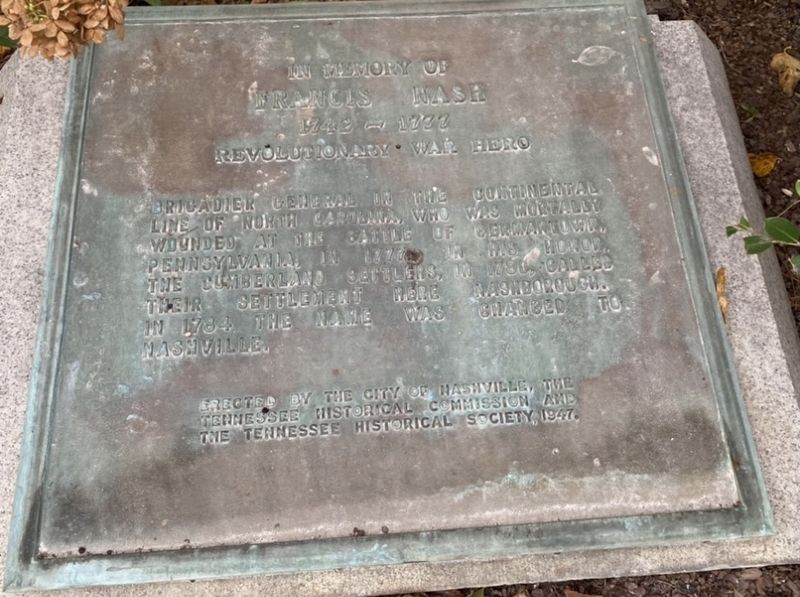
In Memory of Francis Nash
1742 - 1777
Revolutionary War Hero
Brigadier General
in the Continental line of North Carolina, who was mortally wounded at the Battle of Germantown,Pennsylvania in 1777. In his honor, the Cumberland settlers, in . . . — — Map (db m163821) HM
On Fort Negley Boulevard north of Chestnut Street, on the right when traveling north.
Throughout the occupation of Nashville, Federal gunboats dominated the Cumberland River. This made an overland attack from the south the Confederate States Army's most viable option. Late in 1862, the U.S. Army began constructing a complicated . . . — — Map (db m246961) HM
Near West End Avenue at 27th Ave N, on the left when traveling east.
Near this spot stood the home of John Cockrill and his wife, Ann Robertson Cockrill, sister of General James Robertson. Born in North Carolina, on February 10, 1757, Ann Robertson came to the Cumberland Settlement with Donelson's flotilla early in . . . — — Map (db m294141) HM
On 33rd Avenue at West End Avenue (U.S. 70S), on the right when traveling south on 33rd Avenue.
The Nashville Medical Society, the first medical association in Tennessee, was founded March 5, 1821, by seven physicians in the log courthouse on the Public Square. The first president was Dr. Felix Robertson (1781-1865), son of James and Charlotte . . . — — Map (db m147479) HM
Near Kentucky Route 235 0.1 miles south of Route 761, on the left when traveling south. Reported permanently removed.
Captain Arthur M. Rutledge's Tennessee Light Artillery Battery was organized in Davidson County, Tennessee. Rutledge was a West Point graduate who went on to become the Chief of Ordnance in Polk's Army of Mississippi. Rutledge's Tennessee Light . . . — — Map (db m63121) HM
On Charlotte Avenue just west of YMCA Way, on the left when traveling west.
A native of Knoxville, Tennessee, Avon N. Williams, Jr., was an attorney, statewide civil rights leader, politician, educator, and a founder of the Davidson County Independent Political Council and the Tennessee Voters Council. In 1950, as a . . . — — Map (db m147486) HM
Near Jackson Street south of Seventh Street, on the right when traveling south.
Born in North Carolina in 1793, John Nelson was a veteran of the War of 1812 who moved to Tennessee and married Nancy Edwards of Davidson County in 1824. After her death, he migrated to Mississippi and married Maria Ann Robinson of Tennessee. He . . . — — Map (db m114169) HM
Near East Lee Street east of John Sevier Road, on the right when traveling east.
Itinerant pastor to pioneer Lutherans in the Virginia counties of Frederick, Shenandoah, Rockingham, Augusta, Botetourt, Montgomery, Wythe, and Washington; Organizer of numerous congregations in the Shenandoah Valley, in southwest Virginia, in the . . . — — Map (db m173535) HM
A number of years ago the state of Tennessee acquired this tract of land known as "Brentwood Hall" about eight miles south of Nashville in Davidson County. Eventually the "Brentwood Hall" property was declared surplus by the state of Tennessee, but . . . — — Map (db m205313) HM
Though largely forgotten today, John Bell was one of the last great American statesmen. He was born in Davidson County in 1796, the year Tennessee became a state. Bell was elected to the U.S. Congress defeating Felix Grundy, Bell's service, . . . — — Map (db m166482) HM
Near South 2nd Street (Tennessee Route 76) south of Franklin Street, on the left when traveling south.
Clarksville, located along the banks of the Cumberland River, was established by John Montgomery and Martin Armstrong in 1784, before Tennessee became a state. It was governed by the Clarksville Compact of 1784 and named for General George Rogers . . . — — Map (db m169076) HM
On Jr. Gilliam Way at 4th Ave N, on the left when traveling west on Jr. Gilliam Way.
Mayor Karl F. Dean
Metropolitan Government of Nashville and Davidson County, Tennessee
The Nashville Ballpark at Sulphur Dell was made possible by the leadership and foresight of Mayor Karl Dean, who served Nashville and Davidson County . . . — — Map (db m263474) HM
Near 27th Avenue North, on the left when traveling north.
While the state's 100th birthday provided an inspiring theme, the 1897 Tennessee Centennial Exposition was, in fact, a risky economic development scheme. Wall Street's Panic of 1893 had led the nation into a deep economic depression. Despite the . . . — — Map (db m182163) HM
On Long Hollow Pike (Tennessee Route 174), on the right when traveling east.
Here on west bank of the creek that he discovered in 1772, Kasper Mansker and other first settlers built a log fort in 1779. John Donelson’s family fled here in 1780 for safety from Indians. Mansker abandoned the fort in 1781 and moved to Fort . . . — — Map (db m2586) HM
On this site stood one of the principal stations of the Cumberland Settlements. Felix Robertson, son of Col. James Robertson and the first white child born in the Settlement, was born here, Jan. 11, 1781. On Jan. 15 the fort was heavily attacked by . . . — — Map (db m4131) HM
On Union Avenue (U.S. 51) west of Dunlap Street, on the right when traveling west. Reported permanently removed.
Nathan - Bedford - Forrest
MDCCCXXI - MDCCCLXVII
"Those hoof beats die not upon fame's crimson sod,
But will ring through her song and her story;
He fought like a Titan and struck like a god,
And his dust is our ashes of glory."
. . . — — Map (db m51510) HM
Prescribed grazing at the Hermitage improves forage, animal, soil, and water resources.
Animal resources are improved by striving to maintain quality forge 3” to 8” tall. This height allows graze animals to have optimum intake. . . . — — Map (db m81424) HM
Native warm season grasses grow well during the summer heat. These are bunch type grasses, and the bare ground between the grass clumps provides wildlife cover and nesting space. Habitat conditions are excellent for species such as bobwhite quail, . . . — — Map (db m85446) HM
On Hillsboro Road south of Road 254, on the right when traveling north.
Created in 2014, this park protects one of the few remaining undisturbed Mississippian period villages in Davidson County. The Native Americans who lived here were part of a landscape of farms, villages, and mound centers that flourished along the . . . — — Map (db m247864) HM
On Dana Way east of Crossings Blvd, on the right when traveling south.
"George Richards and his wife, Fanny Rogers Richards, emigrated to America from Middlezoy County Somerset, England. He was for many years the manager of the gardens at Edgefield's Fatherland Estate and of those at the Tennessee Asylum, later Central . . . — — Map (db m286673) HM
On West End Avenue at Acklen Park Drive, on the right when traveling east on West End Avenue. Reported permanently removed.
The Nashville Medical Society, the first medical association in Tennessee, was founded March 5, 1821, by 7 physicians in the log courthouse on the Public Square. Pres. was Dr. Felix Robertson, first white child born in Nashville. Chartered Sept. 4, . . . — — Map (db m55018) HM
On 23rd Avenue North at Brandau Place, on the right when traveling south on 23rd Avenue North.
The Nashville Medical Society, the first medical association in Tennessee, was founded March 5, 1821, by 7 physicians in the log courthouse on the Public Square. Pres. was Dr. Felix Robertson, first white child born in Nashville. Chartered Sept. 4, . . . — — Map (db m4522) HM
The North Carolina legislature created Davidson County, named for Valley Forge veteran Brigadier General William Lee Davidson was a small fraction of its original size, the county first embraced most of Middle Tennessee. Cumberland River curves . . . — — Map (db m200235) HM
On Old Glenrose Avenue just east of Dodge Drive, on the left when traveling east.
Mill Creek Baptist Church, mother church of Southern Baptists in Davidson County, occupied two meeting houses at this site from 1797 until the early 20th century. Here, in 1833, Baptists formed the first Tennessee Baptist Convention. The church's . . . — — Map (db m147169) HM
On Broadway at 2nd Avenue North, on the right when traveling east on Broadway.
Sampson W. Keeble, barber, businessman, and civic leader, became the first African-American to serve in the Tennessee General Assembly. Serving from 1873 to 1875, Keeble was appointed to the House Military Affairs Committee and the Immigration . . . — — Map (db m24220) HM
Near Reams Fleming Boulevard 0.5 miles south of McBride Lane, on the right when traveling south.
(side 1)
The Halfacre Reams Fleming Family Cemetery was first laid out on one of the highest points of the Reams Fleming land. On the other prominent peak to the west was constructed Highland Hall, the land's manor house.
The prominent . . . — — Map (db m160315) HM
Indigenous populations lived in the Cumberland Valley of
Middle Tennessee in large villages such as Mound Bottom in
present-day Cheatham County. They were the first farmers of
Tennessee and grew corn, beans, and squash for their own
sustenance . . . — — Map (db m205342) HM
Near Cemetery Street at South Glade Street, on the right when traveling north.
Born near Fredericksburg, Virginia in 1763, John Gordon settled in Nashville about 1782. On the frontier, Gordon made a name for himself as an Indian fighter. He was commissioned by Territorial Governor William Blount as a militia captain in 1793. . . . — — Map (db m196621) HM
The Mexican War
Instigated by the U.S. annexation of Texas and the dispute over its southern boundary, the Mexican War of 1846-1848 resulted in the cession of over 500,000 square miles of the territory then owned by Mexico west of Texas and . . . — — Map (db m85159) HM
Born 1833 on the Hermitage plantation, Davidson County Tennessee as the slave of Andrew Jackson, ex-President of the United States. Escaped to Ohio in 1860. Lived in Columbus 45 years, thirty years in the employ of the Ohio State University. Died . . . — — Map (db m248502) HM
On 7th Avenue North north of Union Street, on the left when traveling north.
The tallest office building in Nashville was purchased from American General Life and Accident Insurance Company by the State of Tennessee on January 3, 1994.
It was originally built in 1970 as the National Life Center, home of the National Life . . . — — Map (db m166570) HM
Near Union Street North at 1st Avenue North, on the right when traveling west.
Thomas H. Shriver (1932-1997) was a Nashville native and a distinguished public servant best remembered as District Attorney General from 1966-1987 and as a Criminal Court Judge from 1987-1997. He was a graduate of Vanderbilt University and . . . — — Map (db m174701) HM
On Union Street at 7th Avenue North, on the right when traveling west on Union Street.
In 1925 Tennessee, Davidson County, and Nashville dedicated the War Memorial Auditorium as an enduring tribute to their sons ad daughters who served the nation on land, sea, and in the air during the First World War. The division of history of the . . . — — Map (db m147726) HM
Mr. Cardwell began his government career in 1958, working for the city of Nashville as a Junior Accountant. He then served the newly-formed Metropolitan Government of Nashville and Davidson County as Auditor (1963-68), Assistant Chief Accountant . . . — — Map (db m221586) HM
On James Robertson Parkway, on the right when traveling east.
The First Methodist Church erected in the Cumberland Settlement was located on the Public Square in present day Nashville, Tennessee in the year 1787.
This monument was located here with the approval of County Judge C. Beverly Briley and the . . . — — Map (db m206250) HM
Near North Carolina Route 73 at McGuire Nuclear Stat Roadd, on the right when traveling east.
Brigadier General William Lee Davidson, the leading partisan officer of the North Carolina piedmont in the Revolutionary War, was killed on the Mecklenburg bank of the Catawba River at Cowan's Ford on February 1, 1781. The exact spot is now under . . . — — Map (db m248196) HM WM
On Harding Place, on the left when traveling east.
On Dec. 16, 1864, Gen. S.D. Lee's Corps, Army of Tennessee, held this right flank of Hood's defense line which ran south along the crest of this ridge. Violent artillery fire and infantry attacks by the corps of Wood and Steedman failed to dislodge . . . — — Map (db m25651) HM
On Tom Austin Highway (U.S. 431) south of Abednego Road, on the right when traveling south.
★ Davidson County ★
Established 1783; named in honor of
Brig. Gen. William Lee Davidson
of North Carolina. Distinguished
officer in the Revolutionary War.
Served with the Army at Valley
Forge. Killed in action at . . . — — Map (db m151813) HM
On South Water Avenue (Old State Highway 109) at James Street, on the right when traveling south on South Water Avenue.
Catherine Blackmore (1806-1888) and her husband Josephus Conn Guild (1802-1883) built Rose Mont circa 1842 here on their 500-acre plantation. Descendants occupied it until the City of Gallatin acquired the property in 1993. A grove of trees 150 . . . — — Map (db m68404) HM
Near Lebanon Pike (U.S. 70) at Rivercrest Pass, on the right when traveling east.
This is one of the few surviving late 19th-century horse barns in Davidson County.
Architectural historians refer to the style of the building as a transverse crib barn, or a central aisle barn. The structure was erected by 1898, most likely when . . . — — Map (db m147663) HM
On Gallatin Pike South 0.2 miles north of Briley Parkway (Tennessee Route 155), on the right when traveling north.
Fort Nashboro settlers began building outposts throughout Davidson County. An area known as Springhill, located on a hill with a freshwater spring, became one of the most important in the development of present day Madison. Spring Hill Cemetery, the . . . — — Map (db m224783) HM
On Valley Pike (U.S. 11) south of Shady Lane, on the right.
Near here was born John Sevier, pioneer and soldier, September 23, 1745. He was a leader in the Indian Wars and the Battle of King’s Mountain, 1780. He was the only governor of the short-lived state of Franklin and the first governor of Tennessee. . . . — — Map (db m654) HM
On Surveyor Road 0.2 miles west of Cloverdale Road, on the left when traveling west.
John Coffee was born in Prince Edward County, VA, in 1772, the son of Joshua and Elizabeth Graves Coffee. The family moved to NC in 1777. After his father died in 1798, Coffee and other family members moved to Davidson County, TN where he . . . — — Map (db m100248) HM WM
On 1st Avenue North at Union Street North, on the right when traveling north on 1st Avenue North.
Lynching in America
Thousands of African Americans were the victims of lynchings and racial violence in the United States between 1877 and 1950. After the Civil War, violent resistance to equal rights for African Americans and an ideology of . . . — — Map (db m147760) HM
On River Highway (North Carolina Route 150) at Mariner Pointe Lane, on the right when traveling west on River Highway.
Among the original pioneers from Pennsylvania, New Jersey, and Maryland who settled on the east side of the Catawba River were George Davidson (1-home destroyed), Reverend John Thomson, Moses White, Hugh Lawson, John Oliphant, John Brevard, . . . — — Map (db m283194) HM
On Old Burkitt Road 0.1 miles east of Nolensville Pike, on the right when traveling north.
Racial Terror Lynchings in America
Thousands of African American men, women, and children were the victims of lynching and racial terror violence in the United States in the century following the end of the Civil War. As the federal . . . — — Map (db m220683) HM
Andrew Jackson built a cotton gin and press at The Hermitage in 1807, both of which stood in the field in front of you. It was a shrewd decision on Jackson's part, not only making his plantation more self-sufficient, but also generating additional . . . — — Map (db m85479) HM
On 1st Avenue North north of Bank Street, on the right when traveling north.
Post-Emancipation Violence in America
After the Confederacy's defeat, the 13th, 14th, and 15th Amendments to the U.S. Constitution ended slavery and guaranteed newly emancipated black people constitutional rights of citizenship. Reconstruction . . . — — Map (db m147755) HM
Near 27th Avenue N 0.2 miles north of Poston Avenue.
The Nashville Parthenon was built on this site as the centerpiece of the Tennessee Centennial Exposition of 1897. The original full-scale replica was intended as a temporary exhibit structure and was constructed of brick, wood and plaster. The . . . — — Map (db m206253) HM
On 2nd Avenue South, on the left when traveling east.
Mr. Cardwell began his government career in 1958, working for the city of Nashville as a Junior Accountant. He then
served the newly-formed Metropolitan Government of Nashville and Davidson County as Auditor (1963-68), Assistant
Chief Accountant . . . — — Map (db m198816) HM
On Murfreesboro Road (Tennessee Route 96) 0.5 miles west of Eddy Lane, on the right when traveling east.
Ewingville
The local newspaper reported in 1875 that Ewingville "is to Franklin what West End is to London; what Brooklyn is to New York; what Edgefield is to Nashville." Ewingville begins on the east bank of the Harpeth River and extends on . . . — — Map (db m149068) HM
On James Robertson Parkway, on the left when traveling east.
Woodland Street Bridge
Built by
Metropolitan Government of Nashville and Davidson County, Tennessee
Beverly Briley, Metropolitan Mayor
Karl B. Stallings, Director of Public Works
Department of Public Works
Project 81 . . . — — Map (db m205411) HM
On 2nd Avenue South, on the left when traveling north.
Born in Nashville, January 27, 1927
Richard H. Fulton graduated from East High School
before attending the University of Tennessee
and serving in the Navy during World War II.
After time as a merchant, he began a public
service career of . . . — — Map (db m198800) HM
On Delray Drive at Illinois Avenue, on the left when traveling north on Delray Drive.
This beautiful new green space on Richland Creek honors Andrew and Martha England, long-time residents of Delray Drive, whose lives were lost in the historic flood of May 2010.
The development of England Park is the result of a collaboration . . . — — Map (db m242734) HM
1783 North Carolina Legislature creates Davidson County, which includes parts
of present-day Rutherford County.
1786 North Carolina Legislature makes initial land grants in Stones River area.
1788 Last elk in county is killed . . . — — Map (db m207990) HM
Thin black lines indicate changes in relevance. Between each pair of lines entries are ordered geographically but all have the same relevance.
* Inflectional forms of words are their plurals, singulars, and possessives as well as gramatical tenses and similar variations.