1138 entries match your criteria. The first 100 are listed. ⊳
Former U.S. Presidents: #01 George Washington Historical Markers
By Mark Hilton, March 7, 2024
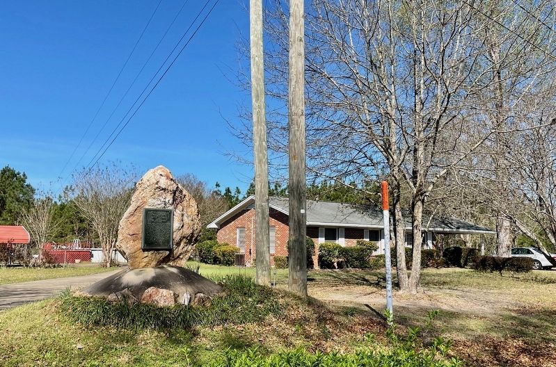
McGillivray Plantation Marker
1 ► Alabama, Elmore County, Wetumpka — McGillivray Plantation — Known As Little Tallase and "The Apple Grove" — 1740 - 1793 —  |
| On Weoka Road (County Road 211) south of Grier Road, on the right when traveling south. | |||
| 2 ► Alabama, Montgomery County, Montgomery — George Washington — 1776 - 1976 — |
| On North Bainbridge Street at Dexter Avenue on North Bainbridge Street. | |||
| 3 ► Alabama, Shelby County, Montevallo — The Lucille Ryals Thompson Colonial Chapel / One Nation Under God — |
| Near Montevallo Road (Alabama Route 119) 0.3 miles south of Alex Mill Road, on the right when traveling south. | |||
| 4 ► Alabama, Shelby County, Montevallo — The President's Oval Office / The Glorious Burden — |
| Near Montevallo Road (Alabama Route 119) 0.3 miles south of Alex Mill Road, on the right when traveling south. | |||
| 5 ► Arizona, Yuma County, Yuma — George Washington — |
| On West 2nd Street (West Court Street) at South 2nd Avenue, on the left when traveling east on West 2nd Street (West Court Street). | |||
| 6 ► Arkansas, Benton County, Bella Vista — Revolutionary War — |
| Near Veterans Way. | |||
| 7 ► Arkansas, Benton County, Bella Vista — United States Commanders in Chief — |
| Near Veterans Way. | |||
| 8 ► California, Los Angeles County, Los Angeles, Hollywood Hills — The Washington Memorial — Thomas Ball - Sculptor — 1819 - 1911 — |
| On Memory Lane just east of Memorial Drive, on the right when traveling east. | |||
| 9 ► California, Los Angeles County, Santa Monica, North of Montana — George Washington — 1732-1799 — |
| Near Ocean Avenue near Alta Avenue, on the right when traveling south. | |||
| 10 ► Colorado, Douglas County, Littleton, Roxborough State Park — Henry S. Persse and His Beloved Roxborough — |
| On Fountain Valley Trail 1.6 miles north of Roxborough Drive. | |||
| 11 ► Connecticut, Capitol Region, Bolton — Bolton — |
| On Bolton Center Rd at Hebron Rd, on the right when traveling east on Bolton Center Rd. | |||
| 12 ► Connecticut, Capitol Region, Bolton — Washington – Rochambeau Revolutionary Route — Bolton — |
| On Bolton Center Rd at Hebron Rd, on the right when traveling east on Bolton Center Rd. | |||
| 13 ► Connecticut, Capitol Region, Farmington — Lest We Forget — |
| On Farmington Avenue (Connecticut Route 4) at Main Street ( Route 10), on the left when traveling east on Farmington Avenue. | |||
| 14 ► Connecticut, Capitol Region, Hartford, Downtown — George Washington — |
| Near Main Street near Central Row, on the right when traveling north. | |||
| 15 ► Connecticut, Capitol Region, Hartford, Downtown — George Washington — |
| On Main Street at Gold Street, on the right when traveling north on Main Street. | |||
| 16 ► Connecticut, Capitol Region, Hartford, Downtown — Jonathan Trumbull — |
| Near Main Street near Central Row, on the right when traveling north. | |||
| 17 ► Connecticut, Capitol Region, Hartford, Downtown — The First Meeting of Washington and Rochambeau — |
| Near Main Street at Central Row, on the right when traveling north. | |||
| 18 ► Connecticut, Capitol Region, Hartford, Downtown — The Wadsworth Barn — This tablet marks the location of the Wadsworth Barn built in 1733 — |
| On Tower Square just west of Prospect Street, on the right when traveling west. | |||
| 19 ► Connecticut, Capitol Region, Hartford, Downtown — Washington – Rochambeau Revolutionary Route — |
| On American Row at Main Street, on the right when traveling west on American Row. | |||
| 20 ► Connecticut, Capitol Region, New Britain — George Washington Bicentennial — |
| On Eddy Glover Boulevard at Commonwealth Avenue, on the right when traveling north on Eddy Glover Boulevard. | |||
| 21 ► Connecticut, Capitol Region, Simsbury, Simsbury Center — This Elm Tree — |
| On Hopmeadow Street (Connecticut Route 10) at Pent Road, on the left when traveling north on Hopmeadow Street. | |||
| 22 ► Connecticut, Capitol Region, Southington, Plantsville — Rochambeau — |
| On Marion Avenue at Burritt Street, on the right when traveling north on Marion Avenue. | |||
| 23 ► Connecticut, Capitol Region, Southington, Plantsville — Washington – Rochambeau Revolutionary Route — |
| On Main Street (Connecticut Route 10) at Grove Street, on the left when traveling north on Main Street. | |||
| 24 ► Connecticut, Capitol Region, Wethersfield — Washington – Rochambeau Revolutionary Route — |
| On Main Street near Marsh Street, on the right when traveling north. | |||
| 25 ► Connecticut, Capitol Region, Wethersfield, Old Wethersfield — The Stillman Tavern — |
| On Main Street at Hart Street, on the right when traveling north on Main Street. | |||
| 26 ► Connecticut, Lower Connecticut River Valley Region, Durham — Durham — |
| On Main Street (Connecticut Route 17) at Fowler Road, on the left when traveling north on Main Street. | |||
| 27 ► Connecticut, Lower Connecticut River Valley Region, Durham — Route of George Washington — |
| On New Haven Road at Madison Road, on the right when traveling north on New Haven Road. | |||
| 28 ► Connecticut, Naugatuck Valley Region, Seymour — Seymour — |
| On Derby Avenue at Broad Street ( Route 313), on the right on Derby Avenue. | |||
| 29 ► Connecticut, Naugatuck Valley Region, Waterbury — Memorial To Two French Soldiers — 1781 - 1914 — |
| Near East Main Street, on the left when traveling west. | |||
| 30 ► Connecticut, Naugatuck Valley Region, Waterbury — Washington – Rochambeau Revolutionary Route — Waterbury, Middlebury, Southbury — |
| On West Main Street at Church Street, on the right when traveling east on West Main Street. | |||
| 31 ► Connecticut, Naugatuck Valley Region, Woodbury — In Memory Of George Washington — |
| On Main Street South (U.S. 6) at Sherman Hill Road ( Route 64), on the right when traveling north on Main Street South. | |||
| 32 ► Connecticut, Northeastern Region, Scotland — Washington-Rochambeau Revolutionary Route — Eastern Connecticut — |
| On Huntington Road (Connecticut Route 14) at Pinch Street, on the left when traveling east on Huntington Road. | |||
| 33 ► Connecticut, Northwest Hills Region, Washington, Washington Depot — Washington — |
| On Bryan Hall Plaza at Calhoun Street ( Route 109), on the right when traveling west on Bryan Hall Plaza. | |||
| 34 ► Connecticut, South Central Region, New Haven, Downtown — Site of First Trinity Episcopal Church — 1732 - 1932 — |
| On Church Street south of Chapel Street, on the right when traveling north. | |||
| 35 ► Connecticut, South Central Region, North Branford — North Branford — |
| On Foxon Road (Connecticut Route 80) at Forest Road ( Route 22), on the left when traveling west on Foxon Road. | |||
| 36 ► Connecticut, South Central Region, Wallingford, Wallingford Center — Nehemiah Royce House — |
| On North Main Street at Dutton Street, on the left when traveling north on North Main Street. | |||
| 37 ► Connecticut, South Central Region, Wallingford, Wallingford Center — Route of George Washington — |
| On Center Street (Connecticut Route 150) west of Fair Street, on the right when traveling west. | |||
| 38 ► Connecticut, Southeastern Region, Colchester — Colchester — |
| On Main Street at Norwich Avenue, on the right when traveling north on Main Street. | |||
| 39 ► Connecticut, Southeastern Region, Lebanon — War Office — |
| On West Town Street at Exeter Road ( Route 207), on the left when traveling north on West Town Street. | |||
| 40 ► Connecticut, Southeastern Region, Lebanon — Washington-Rochambeau Revolutionary Route — |
| On West Town Street at Exeter Road ( Route 207), on the left when traveling north on West Town Street. | |||
| 41 ► Connecticut, Southeastern Region, New London — Nathan Hale — Schoolteacher & Spy from Connecticut — |
| On Water Street at State Street, on the left when traveling north on Water Street. | |||
| 42 ► Connecticut, Southeastern Region, Norwich, Norwichtown — Leffingwell Inn — |
| On Washington Street at Veterans of Foreign Wars Highway (Route 2), on the right when traveling south on Washington Street. | |||
| 43 ► Connecticut, Western Region, Danbury — Washington-Rochambeau Revolutionary Route — |
| On Main Street 0.1 miles north of South Street, on the right when traveling north. | |||
| 44 ► Connecticut, Western Region, Greenwich — George Washington Paused Here — |
| On East Putnam Avenue (U.S. 1) at Maple Avenue, on the left when traveling north on East Putnam Avenue. | |||
| 45 ► Connecticut, Western Region, New Milford — New Milford — |
| On Aspetuck Avenue at Elm Street, on the right when traveling north on Aspetuck Avenue. | |||
| 46 ► Connecticut, Western Region, Newtown — In Commemoration — |
| On Church Hill Road (U.S. 6) at Queen Street, on the right when traveling east on Church Hill Road. | |||
| 47 ► Connecticut, Western Region, Newtown — Washington – Rochambeau Revolutionary Route — Housatonic Crossing — |
| On Church Hill Road (U.S. 6) at Queen Street, on the right when traveling west on Church Hill Road. | |||
| 48 ► Connecticut, Western Region, Redding — 14 — Lake McDougall — Putnam Memorial State Park — |
| Near Putnam Park Road (Connecticut Route 58) at Route 107, on the right when traveling south. | |||
| 49 ► Connecticut, Western Region, Ridgefield, Ridgebury — 28 — Ridgebury – George Washington Slept Here — Ridgefield, Connecticut — The Museum in the Streets — |
| On Ridgebury Road at George Washington Highway, on the right when traveling south on Ridgebury Road. | |||
| 50 ► Connecticut, Western Region, Ridgefield, Ridgebury — Ridgebury Congregational Church — |
| On Ridgebury Road at George Washington Hwy., on the right when traveling south on Ridgebury Road. | |||
| 51 ► Connecticut, Western Region, Ridgefield, Ridgebury — Washington – Rochambeau Revolutionary Route — Ridgefield — |
| On Ridgebury Road at Old Stagecoach Road, on the left when traveling south on Ridgebury Road. | |||
| 52 ► Connecticut, Western Region, Stamford, Downtown — Freedom Shrine — |
| On Atlantic Street at Main Street, on the right when traveling north on Atlantic Street. | |||
| 53 ► Connecticut, Western Region, Westport, Westport Village — Disbrow Tavern — Jennings Trail — |
| On Myrtle Avenue at Church Lane, on the left when traveling north on Myrtle Avenue. | |||
| 54 ► Delaware, Kent County, Magnolia, South Murderkill Hundred — KC-91 — Warner Mifflin — 1745 - 1798 |
| On South State Street just south of Quaker Hill Road, on the left when traveling south. Reported permanently removed. | |||
| 55 ► Delaware, Kent County, Milford, Milford Hundred — KC-114 — Colonel John Haslet — |
| On Airport Road. | |||
| 56 ► Delaware, Kent County, Smyrna, Duck Creek Hundred — KC-60 — Home of Allen McLane — |
| On West Mt. Vernon Street. | |||
| 57 ► Delaware, New Castle County, Glasgow, Pencader Hundred — Delaware Militia |
| On Pulaski Highway (U.S. 40). Reported missing. | |||
| 58 ► Delaware, New Castle County, Glasgow, Pencader Hundred — Marquis de Lafayette |
| On Pulaski Highway (U.S. 40). Reported missing. | |||
| 59 ► Delaware, New Castle County, New Castle, New Castle Hundred — George Washington — |
| On East 4th Street east of Delaware Street, on the left when traveling east. | |||
| 60 ► Delaware, New Castle County, New Castle, New Castle Hundred — NC-A6 — Historic Museum — |
| On Delaware Street at 4th Street, on the right when traveling north on Delaware Street. | |||
| 61 ► Delaware, New Castle County, Newark, Pencader Hundred — NC-A7 — Battle of Cooch's Bridge — |
| On South Old Baltimore Pike at (south) Old Cooches Bridge Road, on the right when traveling west on South Old Baltimore Pike. | |||
| 62 ► Delaware, New Castle County, Newark, Pencader Hundred — Delaware Militia |
| On Sunset Lake Road (Delaware Route 72). Reported damaged. | |||
| 63 ► Delaware, New Castle County, Newark, Pencader Hundred — Marquis de Lafayette — |
| On Sunset Lake Road (Delaware Route 72) south of Old Baltimore Pike, on the right when traveling south. | |||
| 64 ► Delaware, New Castle County, Newark, Pencader Hundred — Washington-Rochambeau Revolutionary Route — |
| On Sunset Lake Road (Delaware Route 72). | |||
| 65 ► Delaware, New Castle County, Newark, Pencader Hundred — NC-53 — Washington's Reconnaissance — |
| On South Old Baltimore Pike, on the right when traveling west. | |||
| 66 ► Delaware, New Castle County, Newark, White Clay Creek Hundred — NC-50 — Hale-Byrnes House — Stanton, Delaware — |
| On Stanton-Ogletown Road 0.3 miles north of Ogletown-Stanton Road, on the right when traveling north. | |||
| 67 ► Delaware, New Castle County, Wilmington, Brandywine Hundred — NC-6 — Gunning Bedford, Jr. — |
| On Concord Pike 0.2 miles north of Route 261, on the right when traveling north. | |||
| 68 ► Delaware, New Castle County, Wilmington, Brandywine Village — NCC-246 — Brandywine Village and the Road to Yorktown — |
| On North Market Street. | |||
| 69 ► Delaware, New Castle County, Wilmington, Brandywine Village — NC-A2 — Joseph Tatnall House — |
| On N. Market Street. | |||
| 70 ► Delaware, New Castle County, Wilmington, Mid-Town Brandywine — A French Legion Kept Watch Here — Washington-Rochambeau Revolutionary Route — |
| On North Market Street south of East 9th Street, on the left when traveling south. | |||
| 71 ► District of Columbia, Washington, Northwest Washington, Capitol Hill — Here were the lots acquired on October 3, 1798 — |
| Near New Jersey Avenue Northwest just south of C Street Northwest, on the right when traveling north. | |||
| 72 ► District of Columbia, Washington, Northwest Washington, Downtown — General Comte Jean de Rochambeau Memorial — Lafayette Square National Historic Landmark District — |
| On Pennsylvania Avenue Northwest at Jackson Place Northwest, on the right when traveling west on Pennsylvania Avenue Northwest. | |||
| 73 ► District of Columbia, Washington, Northwest Washington, Dupont Circle — Tomáš G. Masaryk |
| On Massachusetts Avenue Northwest at 22nd Street Northwest on Massachusetts Avenue Northwest. Reported permanently removed. | |||
| 74 ► District of Columbia, Washington, Northwest Washington, Foggy Bottom — George Washington — |
| On H Street Northwest east of 21st Street Northwest, on the right when traveling east. | |||
| 75 ► District of Columbia, Washington, Northwest Washington, Foggy Bottom — George Washington — |
| On 21st Street Northwest at I Street Northwest, on the right when traveling south on 21st Street Northwest. | |||
| 76 ► District of Columbia, Washington, Northwest Washington, Foggy Bottom — George Washington — |
| On G Street Northwest at 20th Street Northwest on G Street Northwest. | |||
| 77 ► District of Columbia, Washington, Northwest Washington, Foggy Bottom — GW's River Horse — [Lisner Auditorium] — |
| On 21st Street Northwest at H Street Northwest, on the right when traveling south on 21st Street Northwest. | |||
| 78 ► District of Columbia, Washington, Northwest Washington, Foggy Bottom — Lieutenant General George Washington — |
| On Washington Circle Northwest near K Street Northwest (U.S. 29), in the median. | |||
| 79 ► District of Columbia, Washington, Northwest Washington, Foggy Bottom — Marquis de Lafayette Hall — |
| On I Street Northwest west of 21st Street Northwest, on the right when traveling east. | |||
| 80 ► District of Columbia, Washington, Northwest Washington, Georgetown — Forrest Marbury House — Circa 1788 — Category I Landmark, National Register of Historic Places — |
| On M Street Northwest east of 34th Street Northwest, on the right when traveling east. | |||
| 81 ► District of Columbia, Washington, Northwest Washington, Georgetown — Georgetown's Watering Holes — |
| On Wisconsin Avenue Northwest at N Street Northwest, on the right when traveling south on Wisconsin Avenue Northwest. | |||
| 82 ► District of Columbia, Washington, Northwest Washington, Georgetown — In Grateful Commemoration of the Signing of the Constitution — 1787 - 1937 — |
| On Q Street Northwest just west of 27th Street Northwest, on the right when traveling west. | |||
| 83 ► District of Columbia, Washington, Northwest Washington, Georgetown — John Lutz — |
| On Wisconsin Avenue Northwest south of N Street Northwest, on the right when traveling north. | |||
| 84 ► District of Columbia, Washington, Northwest Washington, Georgetown — Old North Building — Erected 1795 — |
| On Old North Way Northwest north of Library Walk Northwest, on the right when traveling north. | |||
| 85 ► District of Columbia, Washington, Northwest Washington, Georgetown — Presidential Visits to Old North — |
| Near Old North Way Northwest north of Library Walk Northwest, on the right when traveling north. | |||
| 86 ► District of Columbia, Washington, Northwest Washington, Shaw — Planning the Federal City — |
| On Rhode Island Avenue Northwest. | |||
| 87 ► District of Columbia, Washington, Northwest Washington, Sheridan-Kalorama — 4 — George Washington — Sheridan Kalorama — Call Box Restoration Project — |
| On Florida Avenue Northwest at Massachusetts Ave Northwest, on the right when traveling south on Florida Avenue Northwest. | |||
| 88 ► District of Columbia, Washington, Northwest Washington, Swampoodle — U.S. Reservation 196 — L'Enfant Plan for the Federal City — National Mall & Memorial Parks, National Park Service, U.S. Department of the Interior — |
| On 1st Street Northwest at New Jersey Avenue Northwest, on the right when traveling north on 1st Street Northwest. | |||
| 89 ► District of Columbia, Washington, Northwest Washington, The National Mall — A Monumental Legacy — National Mall and Memorial Parks — National Park Service, U.S. Department of the Interior |
| On 15th Street Northwest at Madison Drive Northwest, on the left when traveling north on 15th Street Northwest. Reported permanently removed. | |||
| 90 ► District of Columbia, Washington, Northwest Washington, The National Mall — A Monumental Legacy — National Mall and Memorial Parks |
| Near 17th Street Northwest south of Constitution Avenue Northwest (U.S. 50), on the right when traveling north. Reported permanently removed. | |||
| 91 ► District of Columbia, Washington, Northwest Washington, The National Mall — Washington: The City — National Mall and Memorial Parks — National Park Service, U.S. Department of the Interior — |
| Near 15th Street Northwest south of Madison Drive Northwest, on the right when traveling south. | |||
| 92 ► District of Columbia, Washington, Northwest Washington, The National Mall — Washington: The Man — National Mall and Memorial Parks — National Park Service, U.S. Department of the Interior — |
| Near 15th Street Southwest north of Jefferson Drive Southwest, on the right when traveling south. | |||
| 93 ► District of Columbia, Washington, Northwest Washington, The National Mall — Washington: The Monument — National Mall and Memorial Parks — National Park Service, U.S. Department of the Interior — |
| Near 15th Street Southwest north of Jefferson Drive Southwest, on the right when traveling south. | |||
| 94 ► District of Columbia, Washington, Southeast Washington, Capitol Hill — "The Maples" — |
| On D Street Southeast. | |||
| 95 ► District of Columbia, Washington, Southeast Washington, Capitol Hill — 15 — A Fine House In the Woods — Tour of Duty — Barracks Row Heritage Trail — |
| On South Carolina Avenue Southeast just east of 6th Street Southeast, on the right when traveling east. | |||
| 96 ► District of Columbia, Washington, Southeast Washington, Navy Yard — 8 — William Prout: Community Builder — Tour of Duty — Barracks Row Heritage Trail — |
| On 8th Street Southeast at L Street Southeast, on the right when traveling south on 8th Street Southeast. | |||
| 97 ► District of Columbia, Washington, Southwest Washington, The National Mall — A Monumental Legacy — National Mall and Memorial Parks — National Park Service, U.S. Department of the Interior |
| Near 17th Street Southwest north of Independence Avenue Southwest, on the right when traveling north. Reported permanently removed. | |||
| 98 ► District of Columbia, Washington, Southwest Washington, The National Mall — A Monumental Legacy — National Mall and Memorial Parks — National Park Service, U.S. Department of the Interior |
| On Raoul Wallenberg Place Southwest at Jefferson Drive Southwest, on the right when traveling south on Raoul Wallenberg Place Southwest. Reported permanently removed. | |||
| 99 ► District of Columbia, Washington, Southwest Washington, The National Mall — Washington: The City — National Mall and Memorial Parks — National Park Service, U.S. Department of the Interior — |
| On 17th Street Southwest just north of Independence Avenue Southwest, on the right when traveling north. | |||
| 100 ► District of Columbia, Washington, Southwest Washington, The National Mall — Washington: The Man — National Mall and Memorial Parks — National Park Service, U.S. Department of the Interior — |
| On 17th Street Southwest north of Independence Avenue Southwest. | |||
1138 entries matched your criteria. The first 100 are listed above. Next 100 ⊳