August 28, 2010
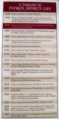
A Timeline of Patrick Henry’s Life
RANKED BY RELEVANCE
| Near Studley Road (Virginia Route 606) 0.1 miles west of Shelton Pointe Drive, on the left when traveling west. |
| Near Rural Point Road (County Route 643) at Heatherwood Drive ( Route 1750). |
| Near Rural Point Road (County Route 643) at Heatherwood Drive ( Route 1750). |
| On Mountain Road (U.S. 33) 0.1 miles north of Old Mountain Road, in the median. |
| On Mechanicsville Turnpike (U.S. 360) 0.7 miles west of Elm Drive, on the right when traveling east. |
| On East Leigh Street at North 11th Street, on the right when traveling west on East Leigh Street. |
| Near Hanover Courthouse Road (U.S. 301) at County Complex Road. |
| Near Heatherwood Drive (Virginia Route 1750) at Rural Point Road ( Route 643). |
| Near Hanover Courthouse Road (U.S. 301) at County Complex Road. |
| On Studley Farms Drive (Virginia Route 700) 0.4 miles south of Studley Road ( Route 606), on the left when traveling south. |
| Near East Broad Street at North 24th Street. |
| Near 25 Alexandria Pike (U.S. 27) at the Evergreen Cemetery entrance, on the right when traveling south. |
| On Rural Point Road (Virginia Route 643) at Pine Slash Road, on the right when traveling north on Rural Point Road. |
| On 27th Street (Virginia Route 143 E) at Jefferson Avenue, on the left when traveling east on 27th Street. |
| On College Road (County Route 692) 0.3 miles south of Five Forks Road (County Route 658), on the right when traveling south. |
| Near Chiswell Lane (Virginia Route 740) 0.1 miles north of Scotchtown Road ( Route 685). Reported permanently removed. |
| Near Red Hill Road (County Route 677) 1 mile Staunton Hill Road (County Route 619). |
| On Lee Highway (U.S. 11) at Wadill Lane, on the right when traveling west on Lee Highway. |
| On Louisa Road (Virginia Route 22) 0.1 miles west of Whitlock Road ( Route 616), on the left when traveling west. |
| Near Red Hill Road (County Route 677) 1 mile south of Staunton Hill Road (County Route 619), on the left when traveling south. |
| On North Washington Highway (U.S. 1) south of Berkley Street, on the right when traveling north. |
| On Hanover Courthouse Road (U.S. 301) 0.2 miles north of Depot Road, on the right when traveling north. |
| Near Hanover Courthouse Road (U.S. 301) at Library Drive. |
| On East Leigh Street (Virginia Route 33) at North 2nd Street, on the left when traveling east on East Leigh Street. |
| On Krause Road at Iron Bridge Road ( Route 10), on the right when traveling north on Krause Road. |
| On James Wharf Road (County Route 637) just west of Mary Ball Road ( Route 3), on the left when traveling west. |
| On Oakland Road (County Route 613), on the right when traveling north. |
| On East Broad Street at North 24th Street, on the right when traveling west on East Broad Street. |
| On Oak Park Drive 0.1 miles east of South Main Street (State Highway 46), on the left when traveling east. |
| On Tyree Lane at Bowles Alley, on the left when traveling west on Tyree Lane. |
| On U.S. 1 south of Cedar Fork Road ( Route 601), on the right when traveling south. |
| Near Heatherwood Drive (Virginia Route 1750) at Rural Point Road ( Route 643). |
| On Red Hill Road at Staunton Hill Road (County Route 619) on Red Hill Road. |
| Near Heatherwood Drive (County Route 1750) at Rural Point Road (County Route 643). |
| On Kenneth Jones Drive 0.2 miles west of Montgomery Avenue, on the left when traveling west. |
| On Market Street east of 3rd Street, on the left when traveling east. |
| On Princess Street just east of North 3rd Street, on the left when traveling east. |
| On North Railroad Avenue south of Henry Clay Road, on the left when traveling south. |
| On Peaks Road (County Route 657) at Mount Hermon Road (County Route 656), on the right when traveling west on Peaks Road. |
| On Chamberlayne Road (U.S. 301) 0.1 miles north of Richmond Times Dispatch Boulevard, on the right when traveling north. |
| Near Verdon Road (Virginia Route 685) 0.2 miles west of New Market Mill Road, on the right when traveling west. |
| Near Verndon Road (Virginia Route 684) 0.2 miles west of New Market Mill Road ( Route 685), on the right when traveling west. |
| Near Courtland Farm Road (Virginia Route 820) 0.2 miles east of Hanover Courthouse Road (U.S. 301), on the right when traveling east. |
| On Admiral Gravely Boulevard at Hobbs Lane, on the right when traveling west on Admiral Gravely Boulevard. |
| On Constitution Highway (Route 20). |
| On Leigh Street (Virginia Route 33) at Second Street, on the left when traveling east on Leigh Street. Reported permanently removed. |
| On South 2nd Street south of Ann Street, on the right when traveling south. |
| Near Rep. John Lewis Way South. |
| Near Hanover Courthouse Road (U.S. 301) at Library Drive. |
| Near Brooke Road (County Road 608) at Canterbury Drive, on the right when traveling north. |
| On Broad Street, on the right when traveling west. |
| On Boonesboro Road (Kentucky Route 388), on the right when traveling south. |
| Near South 17th Street at Independence Boulevard. Reported permanently removed. |
| On Chickies Hill Road south of Cedar Terrace, on the right when traveling north. |
| On Acton Road at Meeting House Road (South Carolina Highway 43-488), on the right when traveling west on Acton Road. |
| On James Madison Highway (U.S. 15) just south of Three Notch Road (U.S. 250), on the right when traveling south. |
| On England Street (Virginia Route 54) west of Maple Street, on the left when traveling west. |
| On Hanover Courthouse Road (U.S. 301) 0.2 miles north of Depot Road, on the right when traveling north. Reported permanently removed. |
| On James Wharf Road (County Route 637) just west of Mary Ball Road ( Route 3), on the left when traveling west. |
| On James Madison Highway (U.S. 15/33), on the right when traveling north. |
| Near Ararat Highway (Virginia Route 773) 0.3 miles west of State Line Road, on the right when traveling west. |
| On Seven Mile Ford Road (State Road 642) west of Spring Branch Road, on the right when traveling west. |
| On South Greenleaf Street at East Adams Street, on the right when traveling north on South Greenleaf Street. |
| On Eaton Street north of East Pembroke Avenue, on the right when traveling south. |
| Near Berkley Street at North Center Street, on the right when traveling west. |
| On Rye Wilderness Road 1 mile east of North Rye Road, on the left when traveling east. |
| On Castle Hayne Road (U.S. 117) at Holly Shelter Road, on the right when traveling north on Castle Hayne Road. |
| On Chickies Hill Road south of Cedar Terrace, on the right when traveling north. |
| On North Washington Highway (U.S. 1) 0.2 miles north of England Street (State Highway 54), on the right when traveling north. |
| Near Verndon Road (Virginia Route 684) 0.2 miles west of New Market Mill Road ( Route 685), on the right when traveling west. |
| On Hanover Courthouse Road (U.S. 301) 0.2 miles north of Depot Road, on the right when traveling north. Reported permanently removed. |
| On Courthouse Road (Virginia Route 49) at Hardy Road (Route 675), on the right when traveling west on Courthouse Road. |
| Near Brumley Road 0.2 miles east of South End Road (North Carolina Highway 615), on the right when traveling east. Reported permanently removed. |
| On E. Pembroke Ave 0.1 miles west of Eaton Street, on the right when traveling west. |
| Near Berkley Street at North Center Street, on the right when traveling west. |
| Near Hanover Avenue south of Thompson Street ( Route 54), on the left when traveling south. |
| Near West Vaughan Street west of Henry Street, on the right when traveling west. |
| Near Ararat Highway (Virginia Route 773) 0.3 miles west of State Line Road, on the right when traveling west. |
| Near Ararat Highway (Virginia Route 773) 0.3 miles west of State Line Road, on the right when traveling west. |
| On Arthur Ashe Boulevard (Virginia Route 161) 0.1 miles south of Stuart Avenue, on the right when traveling south. |
| On North Congress Street (U.S. 11) 0.2 miles north of Lee Highway (U.S. 211), on the left when traveling north. |
| On Stony Hill Road at Hillsborough Road, on the right when traveling east on Stony Hill Road. |
| On Centre Street south of Union Street, on the right when traveling south. |
Thin black lines indicate changes in relevance. Between each pair of lines entries are ordered geographically but all have the same relevance.* Inflectional forms of words are their plurals, singulars, and possessives as well as gramatical tenses and similar variations.
Nov. 12, 2026
