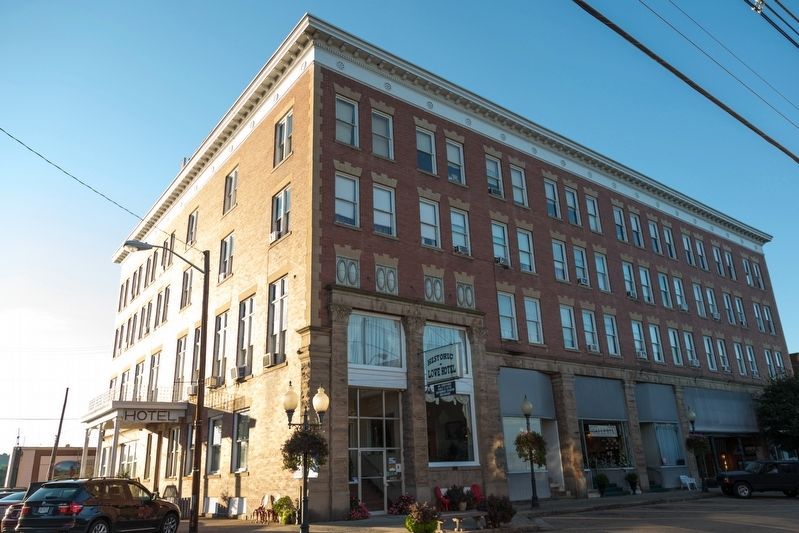
The Mutual Realty Company had this Cleveland berea stone and red brick building erected and was named The Spencer Hotel in honor of Honorable J. S. Spencer as an enduring monument. The doors were opened to the Spencer Hotel in 1904. A barbershop, . . . — — Map (db m125461) HM
Born 1805 in Ireland but moved to Mason County as a child. He served as sheriff and in both houses of Virginia legislature. Delegate to the first Wheeling convention, he was elected president of the first constitutional convention, serving 1861-62 . . . — — Map (db m125016) HM
Born May 6, 1821, Whaley served as a Union recruiter and colonel in the 9th WV Volunteer Infantry. He was captured November 10, 1861, in Guyandotte during the battle there but escaped. First elected to the U.S. Congress in 1861, in 1863 he became . . . — — Map (db m125031) HM
In memory of the veterans of Mason County during the Korean and Viet Nam Wars
May we always be grateful for their sacrifices and love for our great nation — — Map (db m178684) WM
Livia Nye Simpson, born 1 March
1862, was among youngest female
publishers in US with purchase of the
Point Pleasant State Gazette in 1888.
Organized a DAR chapter in 1901;
lobbied for state purchase of Point
Pleasant battlefield; and . . . — — Map (db m125330) HM
Lord Dunmore's War was, in a sense, a focal point in Western history. Here were gathered in either wing of the army the men, who by dint of daring enterprise, had made their way to the frontier and had carried American institutions across the . . . — — Map (db m178628) HM WM
In honor of Mason Countians who have made the supreme sacrifice for our country
In memory of the 46 who lost their lives in the Silver Bridge Disaster Dec. 15, 1967 — — Map (db m178682) HM WM
Civil War
Leonidas M. Godley •
William Baumgarner •
Samuel O. McElhinny •
William H. Barringer •
Hiram R. Howard •
Charles Schorn •
Joseph Vanmatre •
Joel Parsons
World War I
Chester H. West
World War II . . . — — Map (db m232708) WM
Early settlers are buried here. Among those
interred is Dr. Jesse Bennett, the first physician to
perform a successful caesarian section in America in
1794. The patient was his wife. Dr. Bennett's coffin
and 14-foot monument were relocated to . . . — — Map (db m189741) HM
About 1771 was proposed as the capital of a new colony, “Vandalia.” It was visited by early explorers: La Salle, 1669; Celeron, 1749; Gist, 1750; and Washington, 1770. Daniel Boone had a trading post here.
Fort Blair was built . . . — — Map (db m42651) HM
The city of Point Pleasant is located at the confluence of the Ohio and Kanawha Rivers. It is one of the oldest cities along the river. The city was first named by George Washington in 1770. While surveying the area, he named the point of land . . . — — Map (db m178603) HM
Point Pleasant Battle. Here, Oct. 10, 1774, General Andrew Lewis and a thousand Virginia riflemen defeated the federated Indian tribes led by Cornstalk. Known as the "first battle of the Revolution." It was the most important battle between . . . — — Map (db m305737) HM
Mitchell first established this building in the mercantile business with a specialty for supplies. There has been a business on this spot since that time. The Point Pleasant River Museum was established in 2003 with a focus on the history, the lore . . . — — Map (db m178636) HM
After a devastating fire on Sunday July 1, 2018 at 28 Main St., the City of Point Pleasant built a state of the art facility on these grounds, which was purchased by the Point Pleasant River Museum Board, to educate and explore the wonders of our . . . — — Map (db m239226) HM
In memory of Revolutionary Soldiers buried in Mason County, West Virginia. Graves known and unknown outside Tu-Endie-Wei Park.
Akerd (Eckerd) Andrew •
Aleshite (Aleshire), John C. •
Arbuckle, William •
Bumgardner, David •
Bryan, James . . . — — Map (db m125375) HM
Charleston, W.Va., native and one of only three Mountaineer boxers to win a national championship in the history of the program (1933-50) … captured the 1938 national title at 165 pounds and helped WVU earn a three-way tie of the national team title . . . — — Map (db m178680) HM
This was the battle line for the Battle of Point Pleasant, October 10, 1774. Chief Cornstalk's camp was north near Oldtown Creek. General Andrew Lewis' camp was south, at what is now known as Tu-Endie-Wei State Park. — — Map (db m126433) HM
Constructed in 1928, connected Point Pleasant and Kanauga, OH. Name credited to aluminum-colored paint used. First eye-bar suspension bridge of its type in the U.S. Rush hour collapse on 15 December 1967, resulted in 31 vehicles falling into the . . . — — Map (db m124202) HM
On December 15, 1967 at 4:58 pm, the 39-year-old Silver Bridge suddenly collapsed into the Ohio River during heavy rush hour and holiday season traffic. Forty-six lives were tragically lost. The cause of the collapse was a single hairline crack in a . . . — — Map (db m189713) HM
Site of
Silver Bridge Collapse
when 46 lives were lost
Dec. 15, 1967
Mayor
John C. Musgrave
City Clerk
Patty Burdette
City Council
Jack L. Fowler • Harry N. Rhodes
Russell V. Holland • Leonard F. Riffle
Howard Lee Miller . . . — — Map (db m42654) HM
[Front Plaque, Facing East.]
This monument was erected in the year 1909 in commemoration of the Battle of Point Pleasant, fought at the mouth of the Great Kanawha River, now in West Virginia, October 10, 1774. Between twelve hundred and . . . — — Map (db m22553) HM
[Top Inscription on Marker]
Dedicated to those militiamen who were
buried in the magazine and the surrounding battlefield
on OCTOBER 11, 1774
Col. Charles Lewis, Col. John Field, Capt. Thomas Buford,
Cpt. Robert McClenachan, . . . — — Map (db m20797) HM
Built in 1796 by Walter Newman as a tavern, it is currently a museum. This was the first hewn log house in the county and was used as an inn, residence, and a place of public entertainment. Because of its then splendid proportions, it was called the . . . — — Map (db m178635) HM
The “Mansion House” was built in 1796 by Walter Newman for a tavern. It was the first hewn log house in the Kanawha Valley and was made entirely by hand. Later it was enlarged and in 1901 the Daughters of the American Revolution aided by patriotic . . . — — Map (db m241973) HM
One Land, Many Competitors:
Bountiful and beautiful described the land around the Ohio River. Many American Indian tribes lived here and desired to protect their ways of using the land. While relying on the hunting prowess of Indians to . . . — — Map (db m178692) HM
In August of 1925, while steaming
into the port of Cincinnati, the boat
Sallie Marmet hit and sunk on this
anchor. The anchor was then raised
by diver Tom McGuffin and brought
to Point Pleasant, where it was
placed against the park flagpole . . . — — Map (db m125418) HM
Believed to have been a Shawnee altar stone made by the Water Panther Clan, which was Cornstalk's Clan, this stone was found at nearby Leon, WV, at 10-Mile Creek. The spiral shape of the tail is believed to represent the whirlpools that were in the . . . — — Map (db m178630) HM
West Virginia
(Mason County)
"The Mountain State" - western part of the Commonwealth of Virginia until June 20, 1863. Settled by the Germans and Scotch-Irish. It became a line of defense between the English and French during . . . — — Map (db m42650) HM
In memory of the men of Mason County who made the supreme sacrifice in World War II
Mason County men that gave their lives in World War II
Samuel W. Balch •
Zallie Barnett •
Charles P. Barnette •
Earl W. Boyer •
James P. Byus • . . . — — Map (db m178704) WM
Putnam County. Formed in 1848 from Cabell, Mason and Kanawha. Named for Gen. Israel Putnam, a Revolutionary War hero. The county is cut by trails made by American bison to the Ohio River. Its oldest town, Buffalo is named for them.
Mason . . . — — Map (db m178695) HM
The Wells purchased the closed church
building and property with the intention of remodeling the church into their home. The building was too far gone to be salvaged so they saved what they could and
purchased a home to put on the property.
Nancy . . . — — Map (db m265648) HM
In 1790, the La Rue brothers, Frenchmen, built homes in Pleasants County. Isaac settled on Middle Island Creek. Jacob had a home on Middle Island and a mill on Broad Run. Graves of his family are on Middle Island. — — Map (db m80243) HM
Dedicated to
Hiram A. Carpenter
In recognition of his vision for his progress and prosperity of the Ohio Valley....
he proved, in 1928, that dreams build bridges — — Map (db m80245) HM
Dedicated to
Hiram A. Carpenter
In recognition of his vision
for the progress and prosperity
of the Ohio Valley....
he proved, in 1928,
that dreams build bridges. — — Map (db m265647) HM
Born in 1811, he held positions in Tyler County and later Pleasants County, where he was president of the county court. When war erupted. he served as adjutant of the 191st Militia and as a delegate to the 1st and 2nd Wheeling conventions, then . . . — — Map (db m172407) HM
side A
Pleasants County
Formed in 1851 from Ritchie, Tyler, and Wood. Named for James Pleasants, governor of Virginia, 1822-1825, and United States Senator. This county is in the heart of the oil and gas producing territory and has . . . — — Map (db m80244) HM
On October 26, 1863, a small force
of Confederate guerrillas raided
St. Marys, where they stole horses,
boots, and shoes, and seized and
destroyed a cache of weapons. The
raiders also interrupted a German
Ball and forced the men . . . — — Map (db m172274) HM
This mound was part of the Adena culture which flourished from about 800 B.C. to 100 A.D. It is now dedicated as a permanent Archaeological Preserve.
It is named for Lynden E. Reynolds and his wife, Mildred Pritchard Reynolds, who preserved . . . — — Map (db m189887) HM
In 1927 Hiram A. Carpenter, a well-known ferry business owner in
Pleasants County, West Virginia, was witnessing the increase of
automobile ownership in the early 1900's, and through this
phenomena, commerce was increasing as well. Being the . . . — — Map (db m189886) HM
Established as a town, 1851, by Alexander H. Creel on land originally granted to Henry Thomas, Revolutionary soldier, in 1785. Creel built the "Cain House", which became one of the most famous of the Ohio River taverns. — — Map (db m80246) HM
Named for the French town which was made famous by the poet, Petrarch. It was established in 1837 by Alexander H. Creel and was the business center of a large area until St. Marys became the county seat. — — Map (db m80247) HM
This memorial is dedicated to the men and women of Pleasants County who gave their lives and who served their country during the Vietnam War.
May the world rest in peace when all of our brothers are home from Vietnam.
PFC William W . . . — — Map (db m172279) WM
In loving memory of the men
that lost their lives when the
cooling tower collapsed,
April 27, 1978.
Joseph Bafile ·
James Blouir ·
Robert Blouir ·
Steve Blouir ·
Kenneth Boring ·
Richard Bowser ·
Thomas Cross ·
Roger Cunningham . . . — — Map (db m215956) HM
Like a patchwork quilt, the Town of Cairo is and will always be "home" to many. Nestled in a valley among the beautiful "West Virginia Hills" (as we once sung as children), Cairo has withstood the test of time and continues to thrive today much . . . — — Map (db m301943) HM
The marble park where you now stand was constructed in 2006 to commemorate this town's rich marble manufacturing history. The shooting ring is regulation size, and is used frequently throughout the year by young and old alike.
A good . . . — — Map (db m301980) HM
A view of the Masonic Building, which included the G. S. Flesher Drug Store, in about 1925. The drug store was in operation until the early 1960's. It was at that time the largest drug store in West Virginia.
This lively group at left sits . . . — — Map (db m301886) HM
In memory of all World War I Veterans
It was known as the Great War . . . the war to end all wars.
We went "over there" to the songs and cheers of our countrymen, and marched right into the grim reality of twentieth century . . . — — Map (db m301701) WM
Our grateful county and country honor those who served or are serving our country and have helped preserve the freedoms we have today. This memorial was first established to honor not only the memory of a Pearl Harbor survivor, but ALL men and . . . — — Map (db m301783) HM
Cairo Town Square is built on the original site of the Baltimore & Ohio/CSX Railroad Depot. Cairo was a multi-railroad and oil boom town in the mid-1800's and early 1900's. In the 1970's, the CSX Company replaced the original tracks with "Ribbon . . . — — Map (db m301854) HM
This photograph of the Bank of Cairo as it appeared in the 1920's (at right), illustrates how little change has occurred through the years. Built in 1896, and on the National Register of Historical Places, the Italianate architecture was not . . . — — Map (db m301474) HM
Pleasants County
Formed in 1851 from Wood, Tyler and Ritchie. Named for James Pleasants, governor of Virginia, 1822-1825. County's early development was due to resources of oil and natural gas. St. Marys, county seat, founded 1849 by A. H. . . . — — Map (db m301311) HM
(Preface): On April 20, 1863, Confederate Gens. William E. "Grumble" Jones and John D. Imboden began a raid from Virginia through present-day West Virginia on the Baltimore and Ohio Railroad. Taking separate routes, they later reported that . . . — — Map (db m50353) HM
Named for Thomas Harris. His nephew, Gen. Thomas Harris, distinguished himself in the Union Army in Petersburg and Cedar Creek. He was one of the commissioners who tried those charged with plotting assassination of Lincoln. — — Map (db m64098) HM
Harrisville. Laid out on lands owned by Thomas
Harris, uncle of Gen. Thomas Maley Harris, in 1822. Originally part of Wood County, it was chartered in 1832 and incorporated in 1869. The town has been called Solus. Ritchie Court House, and . . . — — Map (db m173702) HM
Gunfire crashed out in the streets around you at noon on May 7, 1863, as hundreds of mounted Confederate raiders commanded by Col. Asher Harman stormed into town from your right. Waiting for them were 75 woefully outmatched members of the . . . — — Map (db m301372) HM
Designed by Holmboe and Pogue of Wheeling, WV, the Ritchie County Courthouse's cornerstone was set on May 30, 1923. For such a rural setting, the Neo-Classical style of the courthouse seems quite elaborate.
Embedded in the stone was a time . . . — — Map (db m301333) HM
Born in Ohio, Freer served in the Union army during the Civil War. He moved to WV in 1866; served as prosecuting attorney for Kanawha, Fayette, and Boone counties; and helped get the state capital moved to Charleston. Moved to Ritchie County, where . . . — — Map (db m173708) HM
Frederick Lemon discovered a vein of natural asphalt near Macfarlan Creek in 1852. Shortly after the Civil War, the narrow-guage Calico Railroad was completed from Cairo to facilitate mining at the newly created boomtown of Ritchie Mines.
After . . . — — Map (db m82103) HM
Doddridge County
Formed in 1845 from Harrison, Ritchie, Tyler and Lewis. Named for Philip Doddridge, lawyer and statesman of western Virginia. Many of the Indians who once came to this State got war and hunting weapons from flint quarries . . . — — Map (db m142407) HM
Settled by John Bunnell, a veteran of the Revolution, near the salt lick which attracted great game herds. The “Stone House,” built about 1807 by John Webster, was one of the famous inns on the Northwestern Turnpike. — — Map (db m42241) HM
Constructed in two phases: east end construction circa 1883; east end remodeled and west end constructed circal 1900. The depot closed in 1974. The last passenger train passed through in the Spring of 1981.
Restoration began in the early . . . — — Map (db m42243) HM
The Webster House, now known as The Stone House, was built shortly after 1800. The walls of the house are two feet thick, constructed of flagstones of various shapes and sizes held together by cement and mortar. John Webster, the builder, sold it to . . . — — Map (db m42239) HM
Ritchie CountyFormed in 1843 from Lewis, Harrison and Wood. Named for Thomas Ritchie, Virginia journalist. In 1772, Elias and Jesse Hughes and Colonel William Lowther explored this region to the Ohio. Hughes River was named by them.
Wirt . . . — — Map (db m130368) HM
The Northwestern Turnpike, a favorite project of George Washington, opened in 1838. Such highways were called "turnpikes" from the gates at which tolls were collected. This town is named for the toll gate which stood here. — — Map (db m80241) HM
Born 1808, he represented Roane
County in 2nd Wheeling Convention,
1861, and voted in favor of a new
state despite pro-Southern views
of his constituents. Arrested by
Confederates upon his return home,
Roberts was sent to Libby Prison . . . — — Map (db m179595) HM
On September 2, 1862, during the Jenkins Raid, Union Col. Rathbone (11th West Virginia Volunteers) surrendered the town of Jenkins without firing a shot in its defense, much to the disdain of men under his command. As a result of their actions, . . . — — Map (db m137929) HM
Confederate Gen. Albert G. Jenkins led 550 cavalrymen on a 500-mile raid from Salt Sulphur Springs, Aug. 22-Sept. 12, 1862, attacking Federal forces and destroying military stores. He captured and paroled 300 Union soldiers, killed or . . . — — Map (db m189967) HM
In honor of
Col. Ruby G. Bradley
U.S. Army Nurse Corps, 30 years.
W.W. II, 1941–1945. Prisoner of war 37 months in the Asiatic Pacific Campaign in the Philippine Islands.
Korean War, 1950–1953.Chief Nurse of the emergency . . . — — Map (db m11221) HM
Roane County. Formed in 1856 from Gilmer, Jackson, and Kanawha. Named for Judge Spencer Roane of Virginia. Land grants to Albert Gallatin and friends in 1787 and 1795, and to the Tiersons and Samuel Hopkins, included most of the county.
. . . — — Map (db m11599) HM
Dedicated to veterans of
The American Revolution • War of 1812 • Mexican War • Spanish-American War
who were residents of what is now Roane County, West Virginia
Erected by RC&D 1995 — — Map (db m189961) HM
In August 1861, a Union militia unit led by Capt. William Pell of Spencer was stationed in Spencer and charged with the area's protection. The first armed conflict consisted of three incidents over 11 days:
1—Confederate guerillas fired on the . . . — — Map (db m11447) HM
April 12, 1861—Confederates attack Fort Sumter.
April 17, 1861—Virginia Secession Ordinance adopted.
June 19, 1861—Statewide vote on ordinance confirmed. Roane County voted in favor of secession, although majority of future West . . . — — Map (db m13900) HM
Visited, 1771, by Jesse Hughes, Indian fighter and scout. In 1812, named Tanner’s Cross Roads for Samuel Tanner. To the west on the Marcellus Hart farm is the deepest oil or gas well east of the Mississippi River, 9104 feet. — — Map (db m14125) HM
Spencer State Hospital, first called
the Second Hospital for the Insane,
opened July 18, 1893. Patients with
many disorders lived in the facility,
as well as elderly people and unwanted
children. Many residents without families
lived there . . . — — Map (db m259445) HM
Formerly
The First Methodist Church
Organized in 1851
and
The Grace Methodist Church
Organized in 1870
Consolidated September 22, 1940 — — Map (db m189970) HM
Born April 20, 1919, Zona, WV, one of 15 children
of Ord and Ethel Gandee Conley
Walton HS 1938 Glenville State College 1938-41
Co. M Spencer National Guard 1939
Awarded Distinguished Service Cross
for gallantry July 13, 1944
Killed . . . — — Map (db m189962) WM
“The memory of those men who went out in their country’s service, whether to the North or to the South, whether returned and buried here, or fell on the field and was laid to rest elsewhere, deserves to be kept.” —William H. Bishop
In the . . . — — Map (db m13933) HM
Corporal Marshall Bailey was working a routine stop at the Wallback Park & Ride off Interstate 79 when he was fatally wounded.
Marshall graduated from Poca High School in 1988 where he played basketball all four years. His senior year, the team . . . — — Map (db m246889)
386 entries matched your criteria. Entries 101 through 200 are listed above. ⊲ Previous 100 — Next 100 ⊳