April 29, 2020
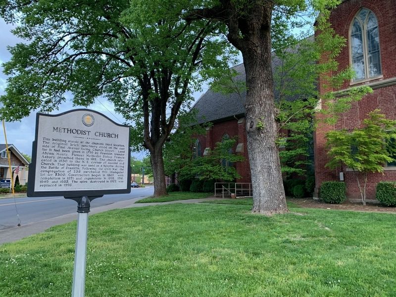
Methodist Church Marker
GEOGRAPHIC SORT Title Sort Marker Number Sort Marker Number Sort for Trails Publication Order Sort Publication Order Sort A Erected Year Sort Most Viewed Sort Most Recent-Interest Sort Most Recently Changed Sort SEE FAQ #33 FOR DESCRIPTIONS
On 5th Ave South (Tennessee Route 106) at Church Street ( Route 246), on the right when traveling south on 5th Ave South.
On Old Natchez Trace 0.3 miles south of Natchez Road, on the right when traveling south.
On Moran Road, on the right when traveling east.
On Moran Road 0.5 miles west of Moran Road, on the right when traveling south.
On Lewisburg Pike (U.S. 431) north of Bethesda-Duplex Road, on the right when traveling south.
On Franklin Road, on the left when traveling north.
On Natchez Street at Acton Street on Natchez Street.
On East Main Street (U.S. 31) west of 1st Avenue North, on the right when traveling west.
On 1st Avenue North north of East Main Street (Business U.S. 31), on the right when traveling north.
On Carters Creek Pike, on the right when traveling north.
On Columbia Avenue (U.S. 31) near W Fowlkes Street, on the right when traveling south.
On 4th Avenue North north of North Margin Street, on the left when traveling north.
On Eddy Court 0.1 miles west of Eddy Lane, on the right when traveling west.
On Mack C. Hatcher Memorial Parkway (U.S. 31/431) 0.2 miles west of Cool Springs Boulevard, on the left when traveling west.
Paid Advertisement
On Velena Street at Rucker Avenue, on the left when traveling east on Velena Street.
On Hillsboro Road (U.S. 431) 0.1 miles south of Sneed Road West, on the left when traveling south.
On Hillview Lane 0.1 miles west of Columbia Pike (U.S. 31), on the left when traveling west.
On Charleston Lane at Sumter Court, on the left when traveling east on Charleston Lane.
On Carters Creek Pike (State Highway 246) at Southall Road, on the right when traveling east on Carters Creek Pike.
On East Main Street (U.S. 31) at 2nd Avenue South, on the left when traveling west on East Main Street.
On Old Natchez Trace 0.1 miles south of Montpier Drive, on the right when traveling south.
On Church Street 0.1 miles west of 3rd Avenue South, on the left when traveling west.
On Del Rio Pike at Hillsboro Road ( Highway 106), on the right when traveling east on Del Rio Pike.
On Wilson Pike (Tennessee Route 252) 0.4 miles north of Tulloss Road, on the right when traveling north.
On Murfreesboro Road (Tennessee Route 96) 0.1 miles east of Ralston Lane, on the right when traveling west.
On Columbia Pike (U.S. 31) north of Coleman Road, on the left when traveling north.
On Boyd Mill Pike 0.3 miles Old Hillsboro Road ( Route 46), on the right when traveling east.
On Bridge Street near 112 Bridge St, Franklin, TN 37064, on the right when traveling west.
On Carnton Lane at Lewisburg Pike (U.S. 431) on Carnton Lane.
On Old Hillsboro Road (Tennessee Route 46) at Old State Highway 96 West, on the right when traveling west on Old Hillsboro Road.
Paid Advertisement
On Bailey Road at Leipers Creek Road ( Highway 46), on the left when traveling north on Bailey Road.
On Leipers Creek Road 0.4 miles west of Pinewood Road ( Route 46), on the left when traveling west.
On Old Hillsboro Road (State Highway 49) 0.1 miles south of Southall Road, on the right when traveling south.
On Old Hillsboro Road (State Highway 46) 0.1 miles east of Wilkins Branch Road, on the left when traveling east.
On King Street north of Old Clovercroft Road when traveling north.
On Nolensville Road (U.S. 41A) at Old Horton Highway, on the right when traveling north on Nolensville Road.
On Nolensville Road (U.S. 41), on the right when traveling north.
On Nolensville Road (Alternate U.S. 31) south of Old Clovercraft Road/Nolensville Park Road, on the left when traveling south.
On Rocky Fork Road at Petral Drive, on the left when traveling west on Rocky Fork Road.
On Peytonsville Road, on the left when traveling east.
On Cool Springs Road, on the left when traveling south.
On Pratt Lane 0.1 miles south of Peytonsville Road, on the right when traveling south.
Near Bethesda Road 0.5 miles Bethesda-Duplex Road, on the left when traveling north.
On Columbia Pike (U.S. 31) 0.3 miles north of Thompson's Station Road, on the right when traveling south.
On Horton Highway (U.S. 31) at Neal Road, on the left when traveling north on Horton Highway.
On Wilson Pike (Tennessee Route 256) at Burke Hollow Road, on the right when traveling north on Wilson Pike.
Paid Advertisement
︽
147 entries matched your criteria. Entries 101 through 147 are listed above.
⊲ Previous 100