International History
Civil Engineering Landmark
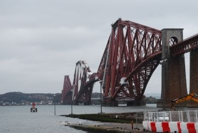
THE FORTH BRIDGE
Opened 4 March 1890
Engineers, Sir John Fowler & Sir Benjamin Baner
Main Contractor Tancred Arrol
Presented 27 August 1985 by
Institution of Civil Engineers . . . — — Map (db m85863) HM
The Royal Navy
In The Forth
During World War I
In March 1903, the British Government announced that Rosyth Dockyard, a new naval port and base, would be built at St Margaret's Hope on the north side of the Forth, but the main works did not . . . — — Map (db m127821) HM
The Antonine Wall was built by the Roman Emperor Antoninus Pius AD 142-143.
It ran for 37 miles from Bridgeness on the Forth to Old Kilpatrick on the Clyde and consisted of a ditch with a turf rampart behind it.
The material from the ditch . . . — — Map (db m86741) HM
THE LANDSCAPE
Around 10,000 years ago the landscape would have been fairly thickly covered with trees. Into this environment came our hunting and gathering ancestors around 8,000 years ago. These people would have cleared some of the trees . . . — — Map (db m86743) HM
The Antonine Wall was built by the Roman Army
on the orders of Emperor Antoninus Pius in the
140's AD. The Antonine Wall replaced Hadrian's
Wall as the far northern frontier of the Roman
Empire at this time, and ran for 40 Roman miles
(60km) . . . — — Map (db m86607) HM
This is the tomb of Captain William Edmonstone of Cambuswallace, killed at the Battle of Falkirk in 1746. It also honours the family of Falkirk-born, US shipping millionaire, Robert Dollar who gifted 13 bells to hang in the church tower — — Map (db m88098) HM
Colonel Robert Munro died at Falkirk Muir when Bonnie Prince Charlie and the Jacobites defeated government troops in 1746. Munro's death was 'universally regretted even by those who slew him' — — Map (db m88096) HM
Constructed:
Grangemouth to Glasgow - 1768-77
Glasgow to Bowling 1785-90
Closed: 1963 - - - Re-opened: 2001
Engineers: J. Smeaton, R. Mackell, R. Whitworth
This canal, which in addition to inland traffic, accommodated full-masted . . . — — Map (db m88039) HM
Sir John de Graeme, William Wallace's right hand man, died during the Battle of Falkirk, when the English defeated Wallace in 1298. Victorian admirers honoured de Graeme's tomb with a wrought iron canopy and replica sword.
'They carried him . . . — — Map (db m88042) WM
(Front)
This Memorial Fountain
is erected
near the spot where
Sir John De Graeme Fell
(Back)
Presented by
Robert Dollar ESQ,
of San Francisco
To Falkirk his native town
in honour of
Sir John De Graeme
and . . . — — Map (db m88100) HM
This stone marks the grave of Sir John Stewart of Bonkhill, who died at the Battle of Falkirk in 1298. He was brother of High Stewart of Scotland, ancestor of the Marquesses of Bute. — — Map (db m88043) WM
The Antonine Wall was built by the Roman army in the 140's AD on the orders of the Emperor Antoninus Pius. For 20 years or more, the Wall was the north west frontier of the Roman Empire. It ran for 40 miles (64 km) from modern Bo'ness on the Forth . . . — — Map (db m86748) HM
The 3rd Marquess of Bute erected this Celtic cross in 1877 to the gallant men of Bute'. They died to a man defending their leader, Sir John Stewart, at the Battle of Falkirk, in 1298 during the Wars of Independence. — — Map (db m88044) WM
From where you are standing, most of the defences of the Roman fort of Rough Castle are behind you. In front of you are the remains of a system of Roman pits which were re-excavated in 1903 and have since been kept open. These originally consisted . . . — — Map (db m86757) HM
The graveyard was cleared in the 1960s leaving only a handful of memorials of historical significance. The grave of Sir John de Graeme who died at the Battle of Falkirk in July 1298 fighting alongside William Wallace is surrounded by a decorative . . . — — Map (db m88046) HM
Immediately in front you can see the Antonine Wall ditch, which forms the northern defences of the Roman fort. The drawing is a bird's-eye view of the site from this position, showing the Roman fort and annex as they would have appeared during . . . — — Map (db m86758) HM
Blackness Castle was built in the 15th century beside the harbour serving the important royal burgh of Linlithgow. It was used as a state prison until the 1707 Treaty of Union, holding for the most part of high or middle rank. The best known . . . — — Map (db m88487) HM
On the night of January 31st 1918, a disaster took place just a few miles off Anstruther when the British Grand Fleet left Rosyth for exercises in the North Sea. With wartime news restrictions in force, few if any people onshore were aware of . . . — — Map (db m88928) HM
There is a tradition that the Mother of Sir William Wallace is buried at this spot marked by a Thorn Tree. This was the former site of the Abbey's weeping cross. — — Map (db m85798) HM
St Andrews Cathedral's chapter house was a magnificent building - a splendid place from which to run the cathedral.
A Busy Place
The canons met here daily to read a chapter of the rule by which they lived, and to confess their faults . . . — — Map (db m88937) HM
St. Rule's Church was the forerunner to the great cathedral. built under Bishop Robert (1123-1159), its enormous tall tower drew pilgrims to the shrine of St. Andrew.
The Tale of St Rule
According to legend, St Rule was a monk in . . . — — Map (db m88940) HM
The initials on the pavement nearby mark thet spot where Patrick Hamilton, Member of the University, was burned at the stake on 29 February 1528, at the age of 24.
On the continent he had been greatly influenced by Martin Luther, and on his . . . — — Map (db m141283) HM
Home to the most senior bishops and archbishops in Scotland, the castle was razed and rebuilt several times over.
The Castle in the 1520s
Archbishop James Beaton built the substantial circular gun towers or block houses in an . . . — — Map (db m88932) HM
(Main plaque:)
This memorial erected 1900 A.D. By public subscription is to mark the site of the house in which the hero of Scotland was basely betrayed and captured about midnight on 5th August 1305 when alone with his faithful friend and . . . — — Map (db m85739) HM
WALLACE'S MONUMENT
The Celtic cross monument to Sir William Wallace was raised by public subscription through the efforts of the Rev David McCrea and the Scottish Patriotic Society.
The monument marks the reputed site of the house in . . . — — Map (db m86605) HM
This Cross
is Reverently Erected
in the Memory of McIan Chief of the MacDonalds
of Glencoe
Who fell with his people
in the Massacre of Glencoe
of 13 Feb: 1692
By his direct descendant
Ellen Burns MacDonald of Glencoe . . . — — Map (db m85791) HM
Highlands & Islands of Scotland
Scrabster Harbour
Skarabolstathar
Caithness and Orkney were settled by the Norse and Skarabolstathar — ‘the homestead at the cliff edge' — is mentioned in the Orkneyinga Saga as a stronghold in . . . — — Map (db m127662) HM
HMS Natal — A Naval warrior destroyed
HMS Natal was a Warrior class Cruiser of 13,550 tons with a complement of 704 officers and men. She was launched at Barrow-in-Furness on 30th September 1905 and had a distinguished peacetime career. This . . . — — Map (db m128195) HM WM
Cromarty Community Council
Birthplace of
James Thomson M.D.
1823 – 1854
A Good Samaritan
to wounded enemy Russians
at the
Battle of Alma
In the Crimean War — — Map (db m127307) HM
Erected By
The Officers Non-Commissioned Officers and Men
Past and Present of the Seaforth Highlanders
Ross-Shire Buffs, the Duke of Albany’s
In Memory of Their Comrades
Who Lost Their Lives in South Africa 1899 – 1902
Killed in . . . — — Map (db m127324) WM
In Memory of Officers N.C.O’s and Men
Of the Royal Burgh and Parish of Dingwall
Who Fell in the Great Wars 1914 – 1918
And 1939 – 1945.
How Bless’d How Glorious They Who Bravely Fall
Their Lives Devoted At Their Country’s . . . — — Map (db m127325) WM
For Their Country
In Memory
of
the Following Officers, N.C.O. & Men
of The Seaforth Highlanders
Who Were Killed In Action
at Fontaine-Notre Dame
On the 21st & 22nd November 1917
Capt. A.K. Fraser. M.C. · Capt. A.M. MacDonald, D.S.O. . . . — — Map (db m127326) WM
In
Memory of
Sergt. John Meikle V.C.M.M.
Late Clerk at Nitshill Station
Who Enlisted in H.M. Forces
(Seaforth Highlanders)
8th February 1915 During the
Great War and was Killed
In Action on 20th July 1918
Erected by His Railway . . . — — Map (db m127327) WM
To the Glory
of God
and in Grateful
Remembrance of
the Officers,
Non. Com. Officers
and Men
From the Parish
of Urqurhart (Ross)
Who Gave Their Lives For
King and Country
In the Great Wars
1914 — 1919.
1939 — . . . — — Map (db m127977) HM
Erected by The Seaforth Highlanders to the undying memory of 8432 comrades belonging to the ten battalions of the regiment who gave their lives for their country in the Great War
Scotland For Ever — — Map (db m34064) HM
Exploring Corrieshalloch Gorge
The thundering River Droma plunges over 100m down through the most impressive slot-gorge in Britain. The forces of nature alone have created this incredible site.
A slot-gorge is an extremely narrow and . . . — — Map (db m127975) HM
The Bridge of Oich
The Old Bridge Is Swept Away
In 1849 floods swept through the Great Glen, breaching the Caledonian Canal behind you and destroying the stone bridge over the River Oich. It took five years before its replacement, this bridge, was . . . — — Map (db m127330) HM
A Castle for All Seasons
Urquhart was transformed many times during its long history, shaped and reshaped by its owners' changing needs and circumstances.
1. The Pictish Hill Fort
The first defences could date from before St Columba's . . . — — Map (db m127302) HM
A Highland Icon
‘S a bhaidealan àrda
Air sgàineadh o chèil’
‘S chan eil eachdraidh no seanchas
A dh'fhàg dearbhadh o chèin
Air an àl chuir an àird e
No dhaingnich a stèidh
Òran do Ghleann urchadain — Tòmas an Todhair
. . . — — Map (db m127243) HM
Academy of Applied Science
Academy of Applied Science
Loch Ness Research Team
United Kingdom Volunteer Associates
Harold and Esther Edgerton · Charles Finkelstein · Martin Klein · John and Annabelle Lothrop · Howard and Ruth Curtis · Tim . . . — — Map (db m127390) HM
1914 — 1918
Great European War
In Honoured Memory of
The Gallant Men
From the Parish and Village
of Ardersier
Who Made the Supreme Sacrifice
Sergt.-Major Thomas H. Bently, A.I.F. · Sergt. George Bain, Cameron Hldrs · Pte Donald . . . — — Map (db m128049) WM
The greatest castle of the Scottish Highlands stands before you. Within its ruined walls, you can discover stories of the remarkable people who lived here, learn more about some of the dramatic chapters in Scotland's history and share memorable . . . — — Map (db m87602) HM
Chapel Yard Cemetery
Cladh Leas A’ Chaibeil
The Chapel Yard Cemetery is one of three old burial grounds in Inverness city centre. The others are at Friars Street and the Old High Church.
The Chapel Yard or St Mary's Cemetery was probably . . . — — Map (db m127329) HM
Destroying the Gatehouse
Blocks of masonry were thrown here by an explosion in 1692 that ended the castle's long military career. Its garrison deliberately destroyed the gatehouse to prevent their Jacobite enemies from holding the medieval fortress . . . — — Map (db m127246) HM
Doocot
This beehive-shaped home for pigeons was built in the 1500s torovide fresh meat and eggs during the harsh winter months. Four of its stone nesting boxes survive.
John Grant was required to build a 'dove grove' under the terms of the . . . — — Map (db m127296) HM
Flora
MacDonald
Fhad’s a dh’ fhàsas
flùr air machair
Mairidh cliù Nathaniel
h-ainnir chaoimh.
— —
“The preserver of Prince Charles
Edward Stuart will be mentioned
in history, and if courage and
fidelity be . . . — — Map (db m127373) HM
Ghosts of Urquhart’s Past
Urquhart Castle is a jigsaw puzzle with most of the pieces missing. Walls have been demolished and new ones raised many times during the last 1,500 years. Timber buildings have rotted away entirely.
Stone Free . . . — — Map (db m127294) HM
Ladich a’ Chlinne a thuit’san arach
In Affectionate
and grateful Memory of
the Glen Urquhart Men
Who fell
in the Great War 1914 - 1918
Major Ian Mackay. · Cap. John Urquhart. · Cap. James Ogilvie Grant Earl of Seafield · Lt J. MacD. . . . — — Map (db m127305) WM
Inverness Castle
Sheriff courthouse and county hall built 1834 · William Burn architect · Here stood the king’s castle in the 12th century when David 1st founded the Royal Burgh of Inverness · The early timber castle was replaced by a high stone . . . — — Map (db m127369) HM
Before the first bridge was built across the Ness in the 12th century, Castle Street was the main route in and out of Inverness. In those days it was called the Doomsdale or the ‘valley of judgement’.
The ‘motte’ has been home to several . . . — — Map (db m127370) HM
John Cobb – World Speed Record Challenger – and – Glen Urquhart
In 1952 John Cobb, who already held the World Land-Speed Record, stayed in Glen Urquhart whilst making his attempt on the World Water-Speed Record on Loch Ness. . . . — — Map (db m128374) HM
On the waters of Loch Ness
John Cobb
having travelled at
206 miles per hour
in an attempt to gain the
World’s Water
Speed Record
lost his life
in this bay
Sept. 29th. 1952
This memorial is erected as a tribute
to the memory of . . . — — Map (db m127174) HM
Loch Ness and the Great Glen
Urquhart guards the Great Glen, An Gleann Mòr in Gaelic, that runs 73 miles (117km) from coast to coast. People have sought to control this route since ancient times. The castle commands Loch Ness as well as . . . — — Map (db m127304) HM
One of Our Aircraft
On the 21st Sept 1985 Wellington Bomber N2980 'R' for Robert was recovered, from a depth of 70 metres at a location 200 metres directly off shore from this point.
The Wimpy was RAF Bomber Commands mainstay in the early years . . . — — Map (db m127401) HM WM
The Chapel
On the rocky knoll above you are the foundations of what may have been Urquhart's chapel. The laird and his family needed somewhere private to hear Mass and receive Holy Communion from a priest.
From Worship to Warfare
There . . . — — Map (db m127253) HM
The Gatehouse
This once mighty structure protected the weakest point in Urquhart's defences — its main entrance.
Attackers had to negotiate the rock-cut ditch that was crossed by a drawbridge you can see where its pillars once fitted, . . . — — Map (db m127248) HM
The Grant Tower
This tower was built some time after King James IV gave Urquhart to John Grant of Freuchie in 1509. It was reward for supporting the monarch in his struggle against the MacDonald Lords of the Isles.
The King's Gift . . . — — Map (db m127258) HM
The Great Hall
Lavish banquets with music, dancing and storytelling were staged in the building before you.
This was where Urquhart's lord or his constable entertained guests and showed off their wealth and status. It was also where they . . . — — Map (db m127255) HM
The Great Kitchen
This room was alive with the sights, sounds and smells of a great medieval kitchen. It was where the culinary creations enjoyed by the 14th-century lord and his guests were concocted.
The discovery of an older kitchen rubbish . . . — — Map (db m127250) HM
The Great Raid of 1545
In 1545, a MacDonald-led force stormed Urquhart. Over the next month they systematically stripped the castle and Glen Urquhart of everything of value. The loot was carried away down the Great Glen. They burned what they could . . . — — Map (db m127252) HM
This pub was officially opened in 1860 by innkeeper Mrs Margaret Patterson. The name of the pub at this time is currently unknown.
However, this pub was open for at least ten years prior to officially becoming a licensed house. This would make . . . — — Map (db m127541) HM
The Magic of Loch Ness
Mòralachd Loch Nis
Welcome to the loch with the monster
Fàilte gu loch an uile-bheist
Did you know that …
St Columba is said to have seen the Loch's elusive monster in the 6th century. But even recent detective . . . — — Map (db m127395) HM
The Majesty of Loch Ness
Mòralachd Loch Nis
Welcome to a monster of a loch
Fàilte gu uile-bheist de locha
Did you know that...
Loch Ness (Nis - possibly a person's name) holds more water than all the lakes and reservoirs in England? . . . — — Map (db m127393) HM
The New Kitchen
Hearty Highland meals may have been prepared here for the residents of the Grant Tower.
The building was part of a small complex added to the castle when it was rebuilt in the 1500s. The old kitchen block had been demolished by . . . — — Map (db m127257) HM
The Private Chamber
The laird of Grant probably entertained close friends here on the first floor and had his bed on the second. Servants may have slept above.
All In the Family
The Grants were based in Strathspey, southeast of . . . — — Map (db m127259) HM
The Service Close
In the 1300s, you would have seen men and women making and repairing clothes, heard wood being worked into furniture and smelt ale being brewed around here.
The service close was sited away from the main castle buildings and . . . — — Map (db m127291) HM
The Stables
These walls may have echoed with the clatter of horses' hooves. Close to the gatehouse, this was the ideal spot for the castle's stables.
Carrying a Heavy Load
Riding horses or ‘coursours' carried nobles; pack horses or . . . — — Map (db m127260) HM
The Trebuchet
To breach the walls of a castle as mighty as Urquhart, an attacker needed siege engines. Most fearsome was the trebuchet, a type of giant catapult that could hurl massive stone balls hundreds of metres.
There is no record of . . . — — Map (db m127245) HM
The Water Gate
This gate linked Urquhart to the outside world. When roads were almost nonexistent, it was easier for people to travel along the loch by boat.
Everything the castle needed came through the water gate, including exotic imports . . . — — Map (db m127293) HM
Upstream, downstream
Suas an abhainn, sìos an abhainn
Look upstream to spot the places among the green spaces.
Highland cathedral Cathair-eaglais Ghàidhealach
St Andrew's Episcopal Cathedral (1874) is the first new cathedral in Britain . . . — — Map (db m127375) HM
Urquhart the Defiant
Urquhart was held by some of the most powerful men in medieval Scotland and forged a reputation as a virtually impregnable fortress during the Wars of Independence.
A New Castle
This is the oldest part of the . . . — — Map (db m127301) HM
A geological sandwich
Sreath air muin sreath
For many people, this is one of the grandest views in Britain — and for geologists it's also one of the most exciting! Look at the scene across the loch and you can see two lines running . . . — — Map (db m127934) HM
A moving story
Siubhal nan clach
The boulders you see perched on top of the low hill across the road weren't always there. The huge blocks of rock once lay many miles to the southeast. So how did they get here?
Chithear ulbhagan mòra . . . — — Map (db m127906) HM
Ardvreck Castle
Seat of the MacLeods of Assynt
An old song makes history alive again,
as a rickle of stones perplex the dark theatre
of the mind with a shouting crowd and,
in the middle, MacLeod of Assynt
and his greater prisoner . . . — — Map (db m127936) HM
Calda House
Conjectural Reconstruction c.1730
Calda is still known locally as the White House and, with its white walls and window and door surrounds of imported dressed sandstone, it must have looked very splendid indeed. It had two . . . — — Map (db m127938) HM
Causeway Tongue House, on the north east side of the Kyle, was rebuilt in 1678 — after being burned by Cromwell's troops — and further added to in 1750. Once the seat of the Mackay chiefs, it has belonged to the Sutherland family . . . — — Map (db m127826) HM
Ceannabeinne
Ceann na Bienne
Ceannabeinne is the township at the end of a chain of hills stretching north from Cranstackie (801 m). The area divides Loch Eriboll from the Kyle of Durness. The pink coloured rock is Lewisian gneiss, commonly found . . . — — Map (db m127828) HM
Ceannabeinne Township Trail
The Highland Township
In the Eighteenth century Ceannabeinne was typical of a farming community in the Highlands. The farm was rented by a Tacksman from Lord Reay, Chief of Clan MacKay. In turn he sub-let the . . . — — Map (db m127829) HM
Ceannabeinne Township Trail
Houses and Homes – Life begins to get better
Of the 14 houses recorded here in 1841, little remains. However, in front of this sign you should be able to make out the rectangular foundation of a house, . . . — — Map (db m127830) HM
Chambered Cairn
Dating to before 2000BC, by far the earliest indication of human occupation in this area is a burial cairn on a knoll above Ardvreck. It was excavated in 1925 and a massive slab lining one side of the chamber can still be seen in . . . — — Map (db m127937) HM
Durness
This stone feature, built in 1886, was originally located at the road junction and housed a clock. It was moved to this location in 1993 when the Village Square was upgraded. George Whyte of Sangomore, the local stonemason, was reputedly . . . — — Map (db m127832) HM
Erected by the
People of Durness
to the
Glory of God
And in Sorrowful
Memory of Their
Noble Dead Who
Fell in the Great
War of 1914 1919.
And also in
Memory of Those
Who Gave Their Lives
1939—1945.
Siol nan Sonn’s . . . — — Map (db m127831) WM
Glacier detectives
Sruthan nam fianais
Icy evidence
Glaciers leave a trail of evidence showing where they've been. But it's not always a simple piece of detective work to find out exactly what happened in the past.
Dileab na deighe . . . — — Map (db m127939) HM
Green and pleasant land
Cluaintean glas is sìtheil
As you arrived in Elphin, did you notice that the grass looks greener here?
This is because the rock under the soil is limestone, which makes the ground more fertile than the . . . — — Map (db m127968) HM
Keoldale Green
Rubha an Tigh Shaille
Rubha an Tigh Shaille is Gaelic for 'Point of the Salt House' more commonly known today as 'Keoldale Green. The land here is an oasis of green in a barren wilderness, the weathering of the ancient Cambrian . . . — — Map (db m127903) HM
County Council of Sutherland
Kyle of Tongue Crossing
This crossing was opened on Friday 3rd September 1971
by
Councillor Mrs C.B. Mackay Tongue
D. McBain, Convenor — Donald Macleod, Chairman — J.B. Rodger, County Clerk
Sir . . . — — Map (db m127827) HM
Kylesku Bridge
Opened by
Her Majesty The Queen
8th August, 1984
The bridge replaces the ferry service which has existed since the early nineteenth century. The bridge was built for the Highland Regional Council and partly financed by the . . . — — Map (db m127908) HM
1883
As A Mark
Of Gratitude And Respect
To The Inhabitants Of
Durness And Eddrachillis
For Their Hospitality,
While Projecting This
Road, This Inscription Is
Placed Over This Well By
Their Humble Servant
Peter Lawson . . . — — Map (db m127905) HM
Stories in sand
Gainmheach Angelo aithris
During the Ice Age, great glaciers and ice sheets gouged out the river valleys and scoured the mountains here. Today, wind and waves help shape this sandy landscape.
Ri Linn na Deighe, rinn . . . — — Map (db m127904) HM
This Cairn Was Erected To
Commemorate the 50th Anniversary of
The XIIth Submarine Flotilla
10th April 1993
The Security of These Top Secret Operations Was
Guarded by the Local People of This District Who
Knew So Much and Talked So Little . . . — — Map (db m127907) HM
To
The Glory
Of God
Jutland · Marne · Mons · Ypres · Loos · Zeebruge · Paschendale · Beaumont Hamel · Ostend · Festubert · Vimy · Neuve Chapelle · Somme · Cambrai · Peronne
Erected to
The Memory of
The Men of Lybster and Swiney
Who . . . — — Map (db m127539) WM
To Commemorate
The Founder of this Village and Harbour
Lieutenant-General Patrick Sinclair
of Lybster
1735-1820
He served in North America 1759 -1784
with the Black Watch and the 15th
Regiment of Foot against the French and
Indians . . . — — Map (db m127540) HM WM
Muir of Ord
"Am Blair Mhor" the Gaelic for Muir of Ord, means a ‘large clear level place' which is easy to be seen on the approach from Beauly. And it was this level space or Muir which was the site of the largest cattle fair in the north from 1820 . . . — — Map (db m127978) HM
To the
Glory of God
and in
Grateful Remembrance
Of the Officers
Non-com Officers
And Men
from the
Parish of Knockbain
Who Gave
Their Lives For
King and Country
In the Great Wars
1914 – 1919
and
1939 – 1945 . . . — — Map (db m127328) WM
The monuments here were built between three and four thousand years ago.
The oldest are a circular walled enclosure - the central 'ring cairn' and two 'passage graves.' The latest was a ring of boulders that enclosed a grave, the 'kerb . . . — — Map (db m91728) HM
‘Nairn Fishwife’
In Nairn, when the fishing industry was at its height in the late 19th century, the Fishwife played a very important role within the community. As well as being responsible for caring for house and family, she also gathered bait, . . . — — Map (db m128034) HM