310 entries match your criteria. Entries 201 through 300 are listed.⊲ Previous 100 — The final 10 ⊳
Historical Markers and War Memorials
in the West Desert Region
By Bill Kirchner, June 16, 2014
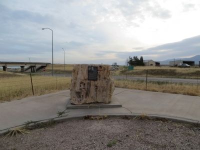
Chief Walkara Marker
201 ► Utah, Millard County, Meadow — Chief Walkara — (Chief Walker, Wakarum) — 1810 ca. - - - - January 29, 1855 —  |
| On North Main Street at Interstate 15, on the right when traveling south on North Main Street. | |||
| 202 ► Utah, Millard County, Meadow — 191 — Settlement of Meadow — |
| On East Center Street at 100 East Street, on the right when traveling east on East Center Street. | |||
| 203 ► Utah, Millard County, Meadow — Taysom Cabin — |
| On Main Street (Utah Route 133), on the right when traveling south. | |||
| 204 ► Utah, Millard County, Oak City — 472 — Oak City / The Bell — |
| On Main Street at Center Street, on the right when traveling north on Main Street. | |||
| 205 ► Utah, Millard County, Scipio — N-1014 — Scipio Town Hall — Utah Historic Site — |
| On North State Street south of 100 North Street, on the right when traveling south. | |||
| 206 ► Utah, Millard County, Scipio — 234 — Settlement of Scipio — |
| On North State Street south of 100 North Street, on the right when traveling south. | |||
| 207 ► Utah, Tooele County, Dugway — 90 — Black Rock Station — |
| On Pony Express-Overland Stage Trail 0.9 miles west of Lincoln Highway 1, on the right when traveling west. | |||
| 208 ► Utah, Tooele County, Dugway — 95 — Burial Plot — |
| On Pony Express Road 1.5 miles south of South Davis Ranch Road, on the right when traveling south. | |||
| 209 ► Utah, Tooele County, Dugway — Hanna Kaaepa — Road to the 19th Amendment — National Votes for Women Trail — |
| On Iosepa Road, on the left when traveling north. | |||
| 210 ► Utah, Tooele County, Dugway — 86 — Lookout Station — Pony Express 1860 - 61 — |
| On Pony Express Road, on the right when traveling east. | |||
| 211 ► Utah, Tooele County, Dugway — 88 — Riverbed Station — |
| On East Pony Express Road, on the right when traveling west. | |||
| 212 ► Utah, Tooele County, Faust — 53 — Faust Station — Pony Express — |
| On Utah Route 36 north of Pony Express Highway, on the right when traveling south. | |||
| 213 ► Utah, Tooele County, Gold Hill — 94 — Burnt Station — |
| On Overland Monument Road, on the left when traveling west. | |||
| 214 ► Utah, Tooele County, Grantsville — Alex and Mary Johnson Home — Utah Historic Site — National Register of Historic Places — |
| On West Main Street at S Hale Street, on the right when traveling east on West Main Street. | |||
| 215 ► Utah, Tooele County, Grantsville — Cedar Mountains Wild Horse Range — Footsteps and Hoofbeats — |
| Near Interstate 80 at milepost 54, on the right when traveling east. | |||
| 216 ► Utah, Tooele County, Grantsville — Donner-Reed Memorial Museum — |
| On North Cooley Street at W Clark Street, on the left when traveling north on North Cooley Street. | |||
| 217 ► Utah, Tooele County, Grantsville — 42 — Grantsville Fort — |
| On West Clark Street, on the right when traveling east. | |||
| 218 ► Utah, Tooele County, Grantsville — Hilda Anderson Erickson — |
| On East Main Street, on the right when traveling west. | |||
| 219 ► Utah, Tooele County, Grantsville — Iosepa Historical Memorial — |
| On Utah Route 196 at milepost 23, 15 miles south of Interstate 80, on the left when traveling south. | |||
| 220 ► Utah, Tooele County, Grantsville — Iosepa Settlement Cemetery — |
| Near Utah Route 196 at milepost 23. | |||
| 221 ► Utah, Tooele County, Grantsville — Jeffries Property Cabin — |
| On North Cooley Street at West Clark Street, on the left when traveling north on North Cooley Street. | |||
| 222 ► Utah, Tooele County, Grantsville — Pioneer Blacksmith Shop — |
| On North Cooley Street, on the left when traveling north. | |||
| 223 ► Utah, Tooele County, Grantsville — The Cherokee Trail — |
| On North Cooley Street, on the left when traveling north. | |||
| 224 ► Utah, Tooele County, Grantsville — The Lincoln Highway — America’s First Coast-to-Coast Automobile Highway |
| On West Clark Street, on the right when traveling west. Reported unreadable. | |||
| 225 ► Utah, Tooele County, Grantsville — This Lonely Fire Hydrant — |
| On Utah Route 196 at milepost 23, 15 miles south of Interstate 80, on the left when traveling south. | |||
| 226 ► Utah, Tooele County, Grantsville — Twenty Wells/Emigrant Graves — |
| On North Cooley Street, on the left when traveling north. | |||
| 227 ► Utah, Tooele County, Ibapah — Atrocities and Hostilities — |
| On Pony Express Overland Trail Road, on the left when traveling north. | |||
| 228 ► Utah, Tooele County, Ibapah — COTNU-14 — Central Overland Trail - Deep Creek Summit — |
| On East Pony Express Road, on the left when traveling west. | |||
| 229 ► Utah, Tooele County, Ibapah — Deep Creek Station — |
| On North Ibapah Co Road, on the right when traveling south. | |||
| 230 ► Utah, Tooele County, Ibapah — 47 — Deep Creek Station — |
| On Old Lincoln Highway, on the left when traveling west. | |||
| 231 ► Utah, Tooele County, Ibapah — Early Settlers of Ibapah — |
| On North Ibapah County Road, on the right when traveling south. | |||
| 232 ► Utah, Tooele County, Ibapah — Eyewitness Accounts — |
| On Pony Express Overland Trail Road, on the left when traveling north. | |||
| 233 ► Utah, Tooele County, Ibapah — Goshute Tribe — |
| On BIA Highway (Highway 1) at Old Lincoln Highway, on the right when traveling south on BIA Highway. | |||
| 234 ► Utah, Tooele County, Ibapah — The Crowds Cheered On... — |
| On Pony Express Overland Trail Road, on the left when traveling north. | |||
| 235 ► Utah, Tooele County, Ibapah — The Lincoln Highway — |
| On North Ibapah Co Road, on the right when traveling south. | |||
| 236 ► Utah, Tooele County, Lakeside — First Explorations to the Great Salt Desert / The Great Salt Desert / The Great Emigrant Flood — |
| On Horseshoe Springs Road, on the right when traveling north. | |||
| 237 ► Utah, Tooele County, Lakeside — HU-10A — Hastings Cutoff - Horseshoe Springs — |
| On Tc02762, on the right when traveling north. | |||
| 238 ► Utah, Tooele County, Lakeside — HU-11 — Hastings Cutoff - Horseshoe Springs — |
| On Horseshoe Springs Road, on the left when traveling west. | |||
| 239 ► Utah, Tooele County, Lakeside — N-38 — Iosepa Settlement Cemetery — Utah Historic Site — National Register of Historic Places — |
| On County Road 02742. | |||
| 240 ► Utah, Tooele County, Ophir — Carl Berg House — |
| On East Main Street at Montana Mine Road, on the right when traveling south on East Main Street. | |||
| 241 ► Utah, Tooele County, Ophir — One Room House — Ophir Utah — |
| On East Silver St. at East Main Street, on the right when traveling west on East Silver St.. | |||
| 242 ► Utah, Tooele County, Ophir — Ore Loading Chute — |
| On Ophir Canyon Road, on the right when traveling west. | |||
| 243 ► Utah, Tooele County, Ophir — Shoe Shop — |
| On East Silver St. at East Main Street, on the right when traveling south on East Silver St.. | |||
| 244 ► Utah, Tooele County, Rush Valley — Fisher Pass — Elevation 6,496 Feet — |
| On South Highway 199, on the left when traveling west. | |||
| 245 ► Utah, Tooele County, Rush Valley — 98 — Rush Valley Station — Pony Express 1860-61 — |
| On Pony Express Trail Road, on the left when traveling east. | |||
| 246 ► Utah, Tooele County, Stansbury Park — Benson Grist Mill — |
| On Utah 138, on the right when traveling west. | |||
| 247 ► Utah, Tooele County, Stansbury Park — Benson Grist Mill — Utah Historic Site — National Register of Historic Places — |
| Near Pole Canyon Road, on the right when traveling west. | |||
| 248 ► Utah, Tooele County, Stansbury Park — Bolinder Blacksmith Shop — |
| Near East Pole. | |||
| 249 ► Utah, Tooele County, Stansbury Park — Boothe Barn — |
| Near Utah 138. | |||
| 250 ► Utah, Tooele County, Stansbury Park — Boothe Granary — |
| Near Utah 138. | |||
| 251 ► Utah, Tooele County, Stansbury Park — Boyer Milk Depot — |
| Near Utah 138. | |||
| 252 ► Utah, Tooele County, Stansbury Park — Forsyth Cabin — |
| Near East Pole. | |||
| 253 ► Utah, Tooele County, Stansbury Park — Gollaher Barn — |
| Near Utah 138. | |||
| 254 ► Utah, Tooele County, Stansbury Park — Johnson Cabin — |
| Near Utah 138. | |||
| 255 ► Utah, Tooele County, Stansbury Park — Liddell Granary — |
| Near Utah 138. | |||
| 256 ► Utah, Tooele County, Stansbury Park — Miller's House — |
| Near Pole Canyon Road. | |||
| 257 ► Utah, Tooele County, Stansbury Park — Pehrson Barn — |
| Near Utah 138. | |||
| 258 ► Utah, Tooele County, Stansbury Park — Pioneer Exhibit Building — |
| Near East Pole. | |||
| 259 ► Utah, Tooele County, Stansbury Park — Sheep Camp — |
| Near Utah 138. | |||
| 260 ► Utah, Tooele County, Stansbury Park — Tanner Cabin — |
| Near East Pole. | |||
| 261 ► Utah, Tooele County, Stansbury Park — Telegraph Car and Payroll Office — |
| Near Pole Canyon Road. | |||
| 262 ► Utah, Tooele County, Stockton — 97 — Steptoe's Military Camp — Godbe's Chicago Smelter — (At Spring 700 feet S.W.) — |
| On Utah Route 36 north of Route 73, on the right when traveling south. | |||
| 263 ► Utah, Tooele County, Tooele — "Proud" — |
| Near West Vine Street. | |||
| 264 ► Utah, Tooele County, Tooele — "Seek On" — |
| On West Vine Street. | |||
| 265 ► Utah, Tooele County, Tooele — 1 — Buffalo Park — |
| On Clinton Landing Road, on the right when traveling north. | |||
| 266 ► Utah, Tooele County, Tooele — 1 — Early Settlers of Tooele County — |
| On West 520 South at 50 W, on the right when traveling south on West 520 South. | |||
| 267 ► Utah, Tooele County, Tooele — Mining in Tooele — |
| Near North Broadway Street at E Vine Street, on the right when traveling north. | |||
| 268 ► Utah, Tooele County, Tooele — 90 — Old Tooele County Courthouse / Existing County Courthouse — 1999 Centennial Year — |
| On South Main Street at E 100 S, on the right when traveling north on South Main Street. | |||
| 269 ► Utah, Tooele County, Tooele — 54 — Old Tooele Ward Church — |
| On West Vine Street at South Main Street, on the right when traveling east on West Vine Street. | |||
| 270 ► Utah, Tooele County, Tooele — 84 — Pioneer City Hall — |
| On East Vine Street east of North Main Street, on the right when traveling west. | |||
| 271 ► Utah, Tooele County, Tooele — 395 — Pioneer Log Cabin — |
| Near East Vine Street east of North Main Street, on the right when traveling west. | |||
| 272 ► Utah, Tooele County, Tooele — Railroads in Tooele County — |
| Near North Broadway Street at E. Vine Street, on the left when traveling north. | |||
| 273 ► Utah, Tooele County, Tooele — The Caboose — |
| Near North Broadway Street at East Vine Street, on the left when traveling north. | |||
| 274 ► Utah, Tooele County, Tooele — The Military in Tooele — |
| Near North Broadway Street at E. Vine Street, on the left when traveling north. | |||
| 275 ► Utah, Tooele County, Tooele — The Powerhouse — |
| Near North Broadway Street at E. Vine Street, on the left when traveling north. | |||
| 276 ► Utah, Tooele County, Tooele — 242 — Tooele Carnegie Free Public Library — |
| On East Vine Street east of North Main Street, on the right when traveling west. | |||
| 277 ► Utah, Tooele County, Tooele — Tooele Cemetery Veterans Memorial — |
| On South 100 East, on the left when traveling west. | |||
| 278 ► Utah, Tooele County, Tooele — 91 — Tooele City Pioneer Cemetery and Memorial Garden — |
| On South Main Street. | |||
| 279 ► Utah, Tooele County, Tooele — Tooele County Courthouse and City Hall — Utah Historic Site — National Register of Historic Places — |
| On East Vine Street east of N Main Street, on the right when traveling west. | |||
| 280 ► Utah, Tooele County, Tooele — Tooele Pioneer Hall — |
| On East Vine Street east of North Main Street, on the right when traveling west. | |||
| 281 ► Utah, Tooele County, Tooele — Tooele Valley Railroad Complex — Utah Historic Site — National Register of Historic Places — |
| Near North Broadway Street, on the left when traveling north. | |||
| 282 ► Utah, Tooele County, Tooele — Tooele Valley Railway Depot — |
| On North Broadway Street at E. Vine Street, on the right when traveling south on North Broadway Street. | |||
| 283 ► Utah, Tooele County, Tooele — Tooele Veteran's Memorial — |
| On West Vine Street. | |||
| 284 ► Utah, Tooele County, Tooele — 331 — Tooele's First Cemetery — |
| On South Main Street, on the right when traveling north. | |||
| 285 ► Utah, Tooele County, Tooele — 147 — Tooele's Mud Wall / Building the Mud Wall — |
| On West Vine Street at N 100 W, on the right when traveling west on West Vine Street. | |||
| 286 ► Utah, Tooele County, Tooele — Working on the Railway — |
| Near North Broadway Street near E Vine Street, on the right when traveling north. | |||
| 287 ► Utah, Tooele County, Vernon — COTNU-3 — Central Overland Trail - Lookout Pass — |
| On Pony Express Road, on the left when traveling west. | |||
| 288 ► Utah, Tooele County, Vernon — OTNU-7 — Central Overland Trail - Simpson Springs — |
| On East Pony Express Road, on the left when traveling west. | |||
| 289 ► Utah, Tooele County, Vernon — Civilian Conservation Corps CCC Camp — |
| On Simpson Springs Campground Road, on the left when traveling south. | |||
| 290 ► Utah, Tooele County, Vernon — Expedient Delivery — |
| On State Highway 36, on the right when traveling south. | |||
| 291 ► Utah, Tooele County, Vernon — Only the Finest Horsemen — Utah West Desert - Faust Station — Pony Express National Historic Trail — |
| On State Highway 36, on the right when traveling south. | |||
| 292 ► Utah, Tooele County, Vernon — Risky Business — |
| On East Pony Express Road, on the left when traveling west. | |||
| 293 ► Utah, Tooele County, Vernon — 87 — Simpson's Spring - Pony Express Station — |
| On East Pony Express Road, on the right. | |||
| 294 ► Utah, Tooele County, Vernon — Stone Cabin — |
| On East Pony Express Road, on the left when traveling west. | |||
| 295 ► Utah, Tooele County, Vernon — Strength and Endurance — |
| On East Pony Express Road, on the left when traveling west. | |||
| 296 ► Utah, Tooele County, Vernon — The Crowds Cheered On… — |
| On East Pony Express Road, on the left when traveling west. | |||
| 297 ► Utah, Tooele County, Vernon — The Crowds Cheered On… — The Route of the Pony Express Trail — Pony Express National Historic Trail — |
| On State Highway 36, on the right when traveling south. | |||
| 298 ► Utah, Tooele County, Vernon — 10 — William Ajax Underground Store — William and Emma J. Hughes Ajax — |
| On Utah Route 36. | |||
| 299 ► Utah, Tooele County, Wendover — Airmen’s Dining Hall and Barracks — |
| On Historic Wendover Airfield. | |||
| 300 ► Utah, Tooele County, Wendover — Atomic Mission Hangar 1831 — |
| Near Historic Wendover Airfield. | |||
310 entries matched your criteria. Entries 201 through 300 are listed above. ⊲ Previous 100 — The final 10 ⊳