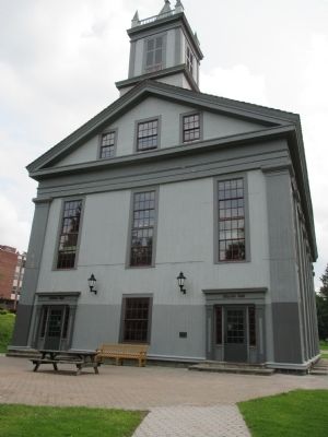
built 1890-1891 by volunteers of A.E. Crandall Hook & Ladder Co. for fire dept. and community events. Became village hall 1973. — — Map (db m171914) HM
Dedicated October 6, 1997.
The Allen-Steinheim Museum was built between 1876 and 1890 by Alfred University's second president, Jonathan Allen. A natural history museum, the Gothic ediface was built from approximately 8,000 different specimens of . . . — — Map (db m75795) HM
was provided through the generosity of Stephen Clarke Saunders '58 and Barbara Potter Saunders '60, and was dedicated in September 1990 as a remembrance of the heritage of Alfred University and as a memorial to the "Education King." William . . . — — Map (db m75759) HM
Abigail Allen, 1824-1902. Early suffragist, reformer, & Alfred University educator declared "Be radical, radical to the core” in 1873 speech — — Map (db m171918) HM
Hamlet formerly named for bridge built by Alpheus Baker, his sons & Joseph Woodruff. Original bridge constructed over Canacadea Creek. — — Map (db m172142) HM
Driller & contractor from PA, who earned nickname of "Dry Hole Ben" by seldom promoting successful oil wells. His continued faith in paying quantities of oil in Allegany County let him drill many historical wells. Including the "Wildcat Well" on . . . — — Map (db m65539) HM
Site gift of Church family, 1801; First burial, 1803; among noted men of Allegany Co. Buried here are; Major M. Van Campen, Capt. P. Church, Judge M. Grover and Rev. C. Fairbank — — Map (db m65538) HM
Original Court House
Allegany County
Erected 1819
Bricks made on the square in front. Angelica Court House, 1858, by Act of Legislature, was to be disposed of And County Seat moved to Belmont. 1860 county divided into two jury districts. 1861 . . . — — Map (db m159376) HM
Founded 1805 by Judge Phillip Church; named for his
mother Angelica Schuyler Church, a sister-in-law of
Alexander Hamilton. Judge Church designed the Park
Circle with public buildings on the perimeter and the
Town Park in the center. Angelica . . . — — Map (db m159374) HM
[front] In honor of our soldiers, the defenders of the Union. Civil War 1861-1865. [base] Gettysburg
[right] Sixth New York Cavalry
1st Lieut. John Muldoon; Lieut. Franklin Saunders
93rd. New York Infantry
Capt. John Sherwood . . . — — Map (db m75785) WM
We dedicate this memorial to those who served in World War II, Korean Conflict and Vietnam, especially those who died for our freedom. — — Map (db m75787) WM
Built by 1856 for use on Genesee Valley Canal, approx. 124-mile-long canal in use until 1878. Railroad later followed canal route. — — Map (db m288808) HM
(front)
Erected
by the
citizens of Amity
1861-1865
(right)
In memory
of the men
of the township
(rear)
who offered
their lives
to their country
(left)
in order
that their country . . . — — Map (db m75782) WM
Used as a burial ground for pioneer families: Lesuer, Tyler, Cowles, Kellogg, Mead, Daniels, Beers, Davie stones date from the 1820's. — — Map (db m88284) HM
Early settler Eli Lesuer bought this property 1834. Elected 1st town assessor 1825, school commissioner 1834, and path master 1846. — — Map (db m88283) HM
The presence of oil in this area of the Allegheny foothills has been known by white men since 1627, when a French missionary reported that the Indians used "a good kind of oil" for medicinal purposes from the nearby Seneca Oil Spring. Production . . . — — Map (db m88286) HM
Canaseraga Four Corners Historic District has been placed on the National Register of Historic Places in 2002 by the United States Department of Interior — — Map (db m151154) HM
1902 Flood destroyed wooden bridge
1903 Camelback Parker Truss Bridge built by Groton Bridge Works at a cost of $6,360.00.
1952 Wooden floor replaced with iron grating
1990 "Grandparents of the Future" chained themselves to the bridge in . . . — — Map (db m75913) HM
1902 Flood destroyed wooden bridge 1903 Camelback Parker Truss Bridge built by Groton Bridge Works at a cost of $6,360.00. 1952 Wooden floor replaced with iron grating 1990 "Grandparents of the Future" chained themselves to the bridge in protest . . . — — Map (db m75916) HM
Here in 1782 Major Moses Van Campen, a soldier of the Revolution, captured by the Senecas, keepers of the Western Door of the Iroquois Confederacy, ran the gauntlet thirty rods west to their ancient council house, which is now preserved in . . . — — Map (db m157328) HM
This building was originally known as the First Presbyterian Church of Centerville. Church members purchased this lot in 1858 and began construction of the church, completing it in 1859 at a cost of $3,000. — — Map (db m75936) HM
As viewed from in front of the Hotel Kinney, Cuba's Main Street was the place to be. The Cuba Baking Co. was a popular stop for school children. Then, going east, lies the Modern Beauty Salon, the Cuba Theater, owned by the Tantillo family, The . . . — — Map (db m307198) HM
Originally built by General Calvin T. Chamberlain, in 1835, The Lafayette House was first of its class and was well known throughout the country for its charm and hospitality. It was named in honor of the Marquis de Lafayette who served the . . . — — Map (db m307199) HM
On this site, the Town of Hume dedicated its World War II Honor Roll in 1943. The use of this area was donated in memory of Robert L. “Bob” and Vonda L. Sylor Bower. The History Club – 2004 — — Map (db m157323) WM
Friendship Free Library
has been placed on the
National Register of
Historic Places in 2008
by the United States
Department of the Interior — — Map (db m258338) HM
In grateful remembrance of the soldiers and sailors who died that the Union might live, Asher W. Miner presents this monument to Hatch Post, 241 G.A.R. Dedicated Aug. 25, 1885. Fraternity, Charity & Loyalty. Gratefully erected in behalf of our . . . — — Map (db m258336) WM
The last one of the Seneca Tribe of Indians that lived in the Town of Caneadea, N.Y. was buried here. His wife died some years before his death. He died March 23, 1864. He said he was 120 years old. — — Map (db m155771) HM
In gratitude to the men of Houghton College who gave their lives for god and country in World War II
1941 — 1946
Bennett, Richard T. U.S.A.A.F.
Danner, Robert M. U.S.A.
Dayton, Warren T. U.S.A.A.F.
Ferchen, Walter F. N.A.F. . . . — — Map (db m157098) WM
albert andrews • benjamin f. andrews • charles b. alfred • daniel blake • col. lyasander burr • fred a. burr • henry l. bigelow • hugh p. bennett • andrew banister • milford butler • crandall bacon • beerly bacon • benson bacon • columbus balcom • . . . — — Map (db m157247) WM
Here was located
the house in which
Willard-J-Houghton
was born July 19, 1825
The foundation stones of this
house form the cross in this
memorial which was erected
by the Class of 1925, the first to
graduate from Houghton . . . — — Map (db m155776) HM
Hanging Bog is a man-made pond built by the Civilian Conservation Corps in the 1930's on then federally owned land. In 1962 Hanging Bog was transferred to New York State. The pond is referred to as Hanging Bog because of its unique mat of floating . . . — — Map (db m86561) HM
1627 Seneca Oil Spring 1927 Forms the first chapter in the development of the petroleum industry in America - a gigantic world enterprise transforming modern life. 1627 Oil in American continent first recorded in this region by the Franciscan . . . — — Map (db m86604) HM
Stands a monument marking the site of the first commercial well in the Richburg Oil Field. Completed April 27, 1881. This marker was erected by local oil producers and the site provided by the Richburg Board of Education. — — Map (db m88333) HM
The area around Scio was first settled around 1805 by Joseph Knight, a minuteman in the American Revolution. Knights Creek, which flows into the Genesee River near Scio, is named for him. Before getting its final name, Scio was called Bloods Corner . . . — — Map (db m175123) HM
David A Howe, born in West Almond, was raised in Wellsville and attended Dickenson Seminary (present day Lycoming College) in Williamsport, PA. He worked in Wellsville before moving to the Williamsport area where he was involved in many business . . . — — Map (db m170713) HM
Perhaps nothing contributed more to the growth of Wellsville than the arrival of the Erie RR in 1851. The railroad brought many new families and businesses to our area and the population almost doubled in size. The old depot was on Loder Street at . . . — — Map (db m175134) HM
In 1832 a group of leaders met at Van Buren's Tavern to choose a name for their community. They selected "Wellsville" after Gardiner Wells who was one of the first settlers and the largest landowner. Wells built the first log house on Main Street . . . — — Map (db m175133) HM
From 1845 to 1905, Wellsville was home to several tanneries that were reported to be the largest in the world. They provided work for hundreds of people in lumbering and tanning. Hemlock bark was used in the tanning process and was stacked in huge . . . — — Map (db m175132) HM
On this site, in 1832, Harmon & Marinda Van Buren built a log house that developed into a hotel, bar, courthouse, and town hall. The house was replaced by the Van Burens with a substantial hotel that was destroyed by fire in 1867. In 1871, Isaac W. . . . — — Map (db m170709) HM
William F Jones, an attorney, banker, and prominent businessman, and his wife Gertrude F. Jones will always be remembered for their generous gift, which made today's Jones Memorial Hospital, a reality. In 1920, they bequeathed their stately home for . . . — — Map (db m170717) HM
1776 - 1976 In memory of the approximately four hundred veterans of the War of Independence who were pioneers in settling the Broome County area. Washington at Valley Forge. — — Map (db m198162) WM
Sacred to the memory
of those who lost their lives
in the Binghamton Clothing Co's
fire July 22, 1913.
Erected by the City of Binghamton.
Twenty one unidentified, buried here
—————— • ——————
Miss Nellie Theresa Connor • Mrs Sarah . . . — — Map (db m256771) HM
Founder and long-time president of the Brotherhood
of Sleeping Car Porters. During World War II he
fought for equal employment in defense industries
for African Americans and after the war won the
fight to ban discrimination in the armed . . . — — Map (db m197937) HM
Alfred Dunk House has been placed on the National Register of Historic Places in 1985 by the United States Department of the Interior — — Map (db m198185) HM
This park was created by the community and the families of those lost on April 3, 2009
Roberta Badaines King
June 20, 1936-April 3, 2009 • United States
"To live in hearts we leave behind is not to die." . . . — — Map (db m283039) HM
Binghamton Municipal
Building — 1897 - 98
Raymond Almirall - Architect
Designated an historic landmark
by the Binghamton Commission on
Architecture & Urban Design — — Map (db m248302) HM
Near this spot, Col. David Ireland trained the 137th NY. They defended the right flank on Culp's Hill at Gettysburg, contributing to Union victory in the battle & Civil War. — — Map (db m198178) HM
This building is named in honor of
Alvin R. Carpenter, M.D. and Donald E. Hunt
who through their special talents as dedicated doctor
and businessman banker, contributed so much to the
Sheltered Workshop and to the care and welfare . . . — — Map (db m283074) HM
A Mexican-American farm worker and labor leader
who co-founded the National Farm Workers
Association, later known as United Farm Workers,
to fight for justice for farm workers.
"Non-violence takes more guts, if I can put it
bluntly, . . . — — Map (db m197895) HM
The southern end of the
97-mile canal (1837-78) was
at the river confluence. It moved
Pa coal, local lumber
& goods to the Erie Canal.
Canal Society
of NYS — — Map (db m92919) HM
This building is dedicated to
Chester B. Lord
in recognition and grateful
appreciation of his deep
compassion, great vision and
enlightened efforts for the Disabled — — Map (db m283070) HM
Located at the convergence of the Chenango and Susquehanna Rivers, Confluence Park is the hub of the Two Rivers Greenway and a meeting of Binghamton’s past and present.
[captions] The South Washington Street Bridge, shown here, was designed by . . . — — Map (db m198124) HM
This park capitalizes on the natural beauty of the Susquehanna and Chenango Rivers, maintaining a strong vista of the river confluence. The hub of a network of Binghamton's riverfront greenways, the park was planned to provide safe public access to . . . — — Map (db m198126) HM
Journalist, publisher, author and an American
civil rights leader. As president of the Arkansas
NAACP, she played an important role in the
Little Rock integration crisis of 1957.
"No man or woman who tries to pursue an ideal
in his or . . . — — Map (db m197921) HM
Dedicated to the memory of our boys who paid the supreme sacrifice in World War II. B.B.B. Factory. Harold Butts, Joseph Curay, Vernon Leamon, Michael Lutsic, Clarence Misner Workshoe Factory. Martin Bernat, John Bezosky Jr. Geo. F. Factory. . . . — — Map (db m198159) WM
On February 11th Donald was driving a tractor fitted with a sweeper brush to remove snow from sidewalks. Donald noticed co-workers shoveling the sidewalks of this bridge. In an act of kindness he volunteered to clear the bridge sidewalks with his . . . — — Map (db m198180) HM
Civil Rights leader and union organizer who
worked alongside MLK, Jr. and also served as
president of the Montgomery NAACP.
"We had a long, hard row to hoe, but we did it with
persistence, great leadership and belief
in ourselves and . . . — — Map (db m197936) HM
Erected
in loving memory of
Ellen Brown
by her Buffalo friends
in grateful recognition
of the fact that she served
for seventeen years as
Boy's Work secretary
of the Y.M.C.A. of Buffalo
the first employed
by an American . . . — — Map (db m256769) HM
One of the Greensboro Four who participated
in the famous "Sit-In" at the Greensboro, NC
Woolworth's store, challenging the store's
policy of segregation.
"Mom, we are going to do something tomorrow that
may change history that might . . . — — Map (db m197885) HM
In August 1964, she testified at the Democratic
National Convention calling for the seating of
the Mississippi Freedom Democratic Party
at that convention.
"The first vote I cast, I cast my first vote for
myself, because I was running . . . — — Map (db m197938) HM
First Presbyterian
Church 1863
J. J. Lyons Architect
Designated an historic landmark
by the Binghamton Commission on
Architecture & Urban Design — — Map (db m256257) HM
A self-educated escaped slave and an American
abolitionist and reformer, he firmly believed
in the equality of all people, regardless of race or sex.
"The life of a nation is secure only while the nation
is honest, truthful, and . . . — — Map (db m197919) HM
Fugitive slaves were aided
on the Underground Railroad
at this site.
Dr. S. Hand house & nearby
A.M.E. Zion and A.M.E. Bethel Church — — Map (db m101993) HM
Harlow E. Bundy House
has been placed on the
National Register of
Historic Places in 2011
by the United States
Department of the Interior — — Map (db m248723) HM
Historic
North Side
Bingham's Patent
Near this site is the
northern boundary of the
land grant of William
Bingham. This was the city
limit until April 4, 1890 — — Map (db m93031) HM
Historic
North Side
The Chenango Canal
Between 1837 and 1875 the
canal linked Binghamton
and Utica. Its general course
followed the line of State
St. which is built on the
filled in canal bed. — — Map (db m93029) HM
Civil War Veterans Ingraham Hill Cemetery
W.H. Brown Co. G 143rd NY Inf. • Joel Butler NYS Vol. 137th Regt. GAR • Luther H. Eldred NYS Vol. Co. H 143rd Regt. • J. H. Landon Co. K 179th Inf. GAR • Unknown Veteran GAR • Unknown GAR Marker . . . — — Map (db m255368) WM
1820 entries matched your criteria. The first 100 are listed above. Next 100 ⊳