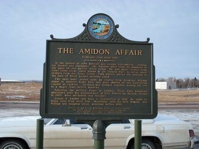
By Roger Dean Meyer, January 1, 2007
The Amidon Affair Marker, side 2
RANKED BY RELEVANCE
| On North Street 0.2 miles north of Maple Avenue, on the right when traveling north. |
| On Main Avenue south of 5th Street, on the right when traveling south. |
| On 255th Street 0.2 miles west of 255th Street, on the right when traveling west. |
| On 258th Street (County Road 130) 0.8 miles west of 475th Avenue (State Route 115), on the right when traveling west. |
| On 481st Avenue (South Dakota Route 11) 0.5 miles north of Route 42, on the right when traveling south. |
| Near West 18th Street west of South Grange Avenue, on the right when traveling east. |
| On West 12th Street (State Highway 42) just west of South Kiwanis Avenue, on the right when traveling east. |
| Near East 12th Street south of East 12th Street. |
| On East 10th Street (State Highway 42) west of South Jessica Avenue, on the right when traveling west. |
| On State Highway 42 0.7 miles east of E 26th St, on the right when traveling west. |
| On West 12th Street just east of South Dakota Avenue, on the right when traveling east. |
| On Mall Avenue at East 9th Street, on the right when traveling west on Mall Avenue. |
| On West 9th Street at South Minnesota Avenue, on the right when traveling east on West 9th Street. |
| On North 2nd Avenue near East Falls Park Drive. |
| On North Garfield Avenue at West Bailey Street, on the right when traveling south on North Garfield Avenue. |
| On Aspen Boulevard west of South Splitrock Boulevard (State Route 11), on the right when traveling west. |
| On 258th Street (County Road 130) 0.8 miles west of 475th Avenue (State Route 115), on the right when traveling west. |
| On South Kiwanis Avenue north of West 46th Street, on the left when traveling north. |
| On South Splitrock Boulevard (State Highway 11) 0.4 miles south of South Sioux Boulevard, on the right when traveling south. |
| On 244th Street 0.3 miles west of 476th Avenue, on the left when traveling west. |
| On 265th Street (South Dakota Route 42) at 456th Avenue ( Route 19), on the right when traveling west on 265th Street. |
| On West Madison Street 0.1 miles east of North Covell Avenue, on the right when traveling east. |
| On W 17th Street at S Main Avenue on W 17th Street. |
| On W 17th Street 0.1 miles west of S Phillips Ave, on the left when traveling west. |
| On W 8th Street 0.1 miles west of S Duluth Avenue. |
| On South Minnesota Avenue at West 9th Street, on the right when traveling north on South Minnesota Avenue. |
| On South Phillips Avenue north of West 10th Street (State Highway 42), on the right when traveling south. |
| On 9th Street east of Phillips Avenue, on the right when traveling east. |
| On North Kiwanis Avenue at West Rice Street, on the left when traveling north on North Kiwanis Avenue. |
| On West Madison Street at North Lincoln Avenue, on the right when traveling west on West Madison Street. |
| On Broadway Avenue at Elm Street, on the left when traveling east on Broadway Avenue. |
| On South Perry Place 0.1 miles north of State Highway 42, on the right when traveling north. |
| On North Phillips Avenue north of West 5th Street, on the right when traveling north. |
| On South Perry Place 0.1 miles north of State Highway 42, on the left when traveling north. |
| On Main Street south of 2nd Street, on the right when traveling south. |
| On South Perry Place 0.1 miles north of State Highway 42, on the right when traveling north. |
| On South Main Avenue at West 11th Street (State Highway 42), on the right when traveling south on South Main Avenue. |
| On North Phillips Avenue south of West 5th Street, on the right when traveling north. |
| On South Phillips Avenue 0.1 miles south of East 14th Street, on the right when traveling north. |
| On West 5th Street (North Dakota Avenue) west of North Main Avenue, on the right when traveling east. |
| On South Main Avenue south of West 11th Street (State Highway 42), on the right when traveling south. |
| Near East Falls Park Drive at North 2nd Avenue. |
| On Interstate 90, on the right when traveling west. |
| Near 252nd Street east of 481st Avenue, on the right when traveling west. |
| Near 264th Street 0.5 miles west of 484th Avenue (County Road 109), on the left when traveling west. |
| On South Main Avenue at West 1st Street (County Road 110), on the right when traveling south on South Main Avenue. |
| On North Drive 0.3 miles east of East Maple Street, on the right when traveling east. |
| On West 9th Street at South Dakota Avenue on West 9th Street. |
| Near 264th Street 0.5 miles west of 484th Avenue (County Road 109), on the left when traveling west. |
| On South Perry Place 0.1 miles north of State Highway 42, on the left when traveling north. |
| On South Perry Place 0.1 miles north of State Highway 42, on the left when traveling north. |
| On South Phillips Avenue south of East 12th Street, on the right when traveling north. |
| On South Perry Place 0.1 miles north of State Highway 42, on the left when traveling north. |
| On South Phillips Avenue south of 9th Street, on the right when traveling south. |
| On South Perry Place 0.1 miles north of State Highway 42, on the right when traveling north. |
Thin black lines indicate changes in relevance. Between each pair of lines entries are ordered geographically but all have the same relevance.* Inflectional forms of words are their plurals, singulars, and possessives as well as gramatical tenses and similar variations.
Nov. 13, 2026
