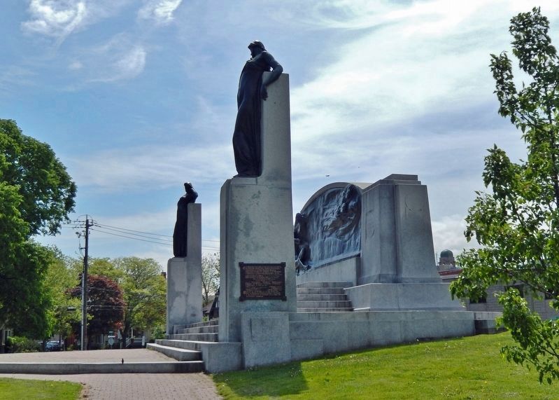
On West Street just north of Wellington Street, on the right when traveling north.
This Monument the work of Walter S. Allward, R.C.A. Sculptor, was placed here through International subscription by the Bell Telephone Memorial Association to mark the invention of the Telephone at Brantford by Alexander Graham Bell in 1874 — . . . — — Map (db m215700) HM
On Wellington Street just west of George Street, on the right when traveling west.
Architect John Turner and contractor William Sinon built this court house for the Provisional County of Brant in 1852-53. Turner was Brantford's most influential nineteenth-century architect, designing several important public buildings in Brant . . . — — Map (db m198273) HM
On Wellington Street just east of Market Street, on the left when traveling east. Reported missing.
In July, 1852, the Six Nations Indians sold to Brant County the land upon which this court-house now stands. Designed by John Turner and William Sinon and erected by the Provisional County of Brant, the stone and brick building was largely . . . — — Map (db m198271) HM
On Tutela Heights Road, 0.8 kilometers east of Mount Pleasant Road, on the left when traveling east.
In 1877 this house, then located in downtown Brantford,
became Canada's first telephone business office. It was
the residence of the Reverend Thomas Philip Henderson
(1816-1887), a former Baptist minister and school
inspector in Paris, . . . — — Map (db m230401) HM
On Dalhousie Street just west of Market Street, on the left when traveling west.
Lingering Snow, oil on canvas, n.d. Collection of Glenhyrst Art Gallery of Brant George Thomson was born in Claremont, Ontario in 1868 and, at the age of nine, moved to Rose Hill Farm outside Leith, near Owen Sound. He is the oldest . . . — — Map (db m222039) HM
Near Mohawk Street close to Morrison Road, on the left when traveling west.
English: Originally called St. Paul's, this chapel was the first Protestant church in Upper Canada and is now the oldest surviving church in Ontario. Built by the Crown in 1785, it was given to those Mohawk Indians led by Joseph Brant who . . . — — Map (db m83743) HM
A Grand Legacy
In 1994, the Grand River was formally designated a Canadian Heritage River.
This honour recognizes rivers of outstanding significance and their important role in Canadian history. The Grand is unique, as it is the only . . . — — Map (db m240760) HM
On Colborne Street East just east of Johnson Road, on the right when traveling east.
Across the Grand River at this point lies "Bow Park", once the farm of George Brown, a leading architect of Confederation, who built up an estate of some 800 acres beginning in 1866. A Scottish immigrant, Brown founded the Toronto "Globe" in 1844, . . . — — Map (db m215793) HM
On Market Street just north of Darling Street, on the right when traveling north.
Log Cabin, oil on canvas, n.d. Collection of the City of Brantford John Claude Whale is the second son of painter Robert R. Whale and was born during his parents' voyage from England to Canada. A self-taught artist like his father, he . . . — — Map (db m243605) HM
On Lynnwood Drive just south of Glenwood Drive, on the right when traveling south.
Marsh Birds, oil on canvas, 1878 Collection of Glenhyrst Art Gallery of Brant John Hicks Whale was born in Liskeard, England in 1829 and is the nephew of artist Robert R. Whale. He emigrated to Canada in the early 1850s and married . . . — — Map (db m243674) HM
Near Ava Road, 0.4 kilometers north of Paris Road.
Born into a prominent Brantford family, Lawren Harris began to paint as a child. At the University of Toronto, a professor noticed he sketched during lectures and advised he be sent to Europe to study art. While in Germany (1904-1907), . . . — — Map (db m239617) HM
On Darling Street west of Market Street, on the left when traveling west.
Three Chords, lithograph print, 1973 Collection of Glenhyrst Art Gallery of Brant Michael Snow is among the world's most celebrated artists and filmmakers. Born in Toronto in 1928, Snow's artwork and films have been exhibited at art . . . — — Map (db m221940) HM
On Mohawk Street close to Morrison Road, on the left when traveling west.
English: Allies of the British during the American War of Independence, the Six Nations Iroquois received extensive lands along the Grand River in 1784. Mohawks, led by Joseph Brant, established a village of some 400 individuals here by . . . — — Map (db m83697) HM
On George Street just north of Darling Street, on the right when traveling north.
Designed by John Turner and built in 1883, Park Baptist Church served as a place of worship for over a century until a dwindling membership led to closure in 1992. The fate of the building remained uncertain until 2000 at which time restoration . . . — — Map (db m215890) HM
On West Street just east of Brant Avenue, on the left when traveling east.
[English]To commemorate our heroic Polish and Canadian soldiers under British Command in World War II To honor war veterans who fought for world freedom and all the people that endured suffering and hardship[Polski]Pamieci bohaterów . . . — — Map (db m243591) WM
On Colborne Street East, 0.3 kilometers east of Wayne Gretzky Boulevard, on the right when traveling east.
This house, "Echo Villa", was built by the Reverend Peter
Jones (Kahkewaquonaby) who lived here from 1851 until
his death. Son of the noted surveyor, Augustus Jones, and
Tuhbenahneequay, a Missisauga chief's daughter, Peter was
born at . . . — — Map (db m237708) HM
On Dalhousie Street just west of George Street, on the right when traveling west.
Royal Victoria Place, originally known as the Commercial Buildings, was designed by John Turner and built in 1881 by Bernhard Heyd. One of the first occupants was the Royal Loan and Savings Company. Following a devastating fire in 1988, . . . — — Map (db m215851) HM
On West Street just north of Chatham Street, on the left when traveling north.
[English] Pioneering journalist in the late 19th century, Sara Jeannette Duncan challenged social and political norms by examining women’s changing roles, the need for a national culture, and the way Canadian politics . . . — — Map (db m215697) HM
On West Street just north of Chatham Street, on the left when traveling north.
[English] An internationally renowned author, Duncan was raised in the adjacent house and educated locally. She taught school briefly, but then determinedly turned to journalism, gaining notice for her distinctive and witty writing . . . — — Map (db m215698) HM
Near Mohawk Street close to Morrison Road, on the left when traveling west.
English:
This chapel, the first Protestant church in Ontario, was built by the Crown for the Mohawks of the Six Nations Iroquois who settled here in 1794. It replaced the Queen Anne Chapel (1712) at Fort Hunter, New York, which the Mohawk . . . — — Map (db m83694) HM
Near Darling Street just west of George Street, on the right when traveling west.
This National Monument erected by the Brant Memorial Association, Incorporated 41 Vic. Cap. 62 S.O. to Thayendanegea. Capt. Joseph Brant born 1742 died 1807 interred at Mohawk Church and to The Six Nations Indians for their . . . — — Map (db m215797) HM
On Tutela Heights Road, 0.8 kilometers east of Mount Pleasant Road, on the left when traveling east.
The Bell Homestead
Here at his parents' home in July 1874, Alexander Graham
Bell conceived the fundamental idea of the telephone and, in August 1876, carried out the first successful long-distance trials. The Homestead evokes the . . . — — Map (db m230331) HM
On Brant Avenue at Scarfe Avenue, on the right when traveling north on Brant Avenue.
Originally dedicated November 11, 1923, and moved from Gore Park to this site on June 2, 1992. The members of the Imperial Order Daughters of the Empire were the sole contributors to this Cenotaph, the only one in Brantford at that time. The . . . — — Map (db m243640) HM WM
On Wellington Street just east of George Street, on the left when traveling east.
In the 1820's significant improvements to the Hamilton and London road attracted settlers to the Indian lands at Brant's Ford where this thoroughfare crossed the Grand River. A thriving village soon developed and in 1830 the Six Nations surrendered . . . — — Map (db m199047) HM
On Tutela Heights Road, 0.8 kilometers east of Mount Pleasant Road, on the left when traveling east.
Invention of the Telephone
Even here at his father's home where he came for rest
and peace, Alexander Graham Bell continued to ponder
the elusive secret of voice transmission, and it was here,
on 26 July 1874, that insight finally . . . — — Map (db m230396) HM
On Mohawk Street, on the right when traveling west.
The Mohawk Institute
The Mohawk Institute was established in 1831 for children of the Six Nations Iroquois living on the Grand River. Pupils from other native communities in Ontario attended the school as well. Like all Canadian . . . — — Map (db m230264) HM
A Brief History...
• 11,000 Years Ago - Nomadic hunter/ gatherer culture in tundra-like environment of the Grand River Valley.
• 9000 Years Ago - Hunter/gatherer culture begins to implement seasonal migratory camps.
The environment has . . . — — Map (db m240764) HM
Near Mohawk Street close to Morrison Road, on the left.
Tomb Inscription
This tomb is erected to the memory of THAYENDANEGEA , or Captain Joseph Brant, Principal Chief and Warrior of the Six Nations Indians, by his Fellow-Subjects, admirers of his fidelity and attachment to the British . . . — — Map (db m83696) HM
Near Darling Street just west of George Street, on the right when traveling west.
Victoria Park was set aside as a square when Lewis Burwell surveyed the original town plan for Brantford in 1830. The square was first landscaped as a formal park in 1861. The plans were prepared by John Turner, a local architect who designed many . . . — — Map (db m215847) HM
On West Street just north of Wellington Street, on the right when traveling north.
[English] An outstanding sculptor of some of Canada's finest public monuments, Walter Allward is best known for his masterpiece, the Vimy war memorial in France. He emerged as a dominant figure in the transition from . . . — — Map (db m215699) HM
Near Myrtleville Drive, 0.3 kilometers west of Balmoral Drive, on the right when traveling west.
[English] A leading spokesman for Canadian agrarian and co-operative movements, Good was born and raised on Myrtleville farm. He early developed a strong sense of social responsibility and, returning here after attending the . . . — — Map (db m217700) HM
Near George Street just north of Wellington Street, on the right when traveling north.
Landscape with Tree, oil on board, n.d. Collection of Glenhyrst Art Gallery of Brant William Henry Clapp was born in Montreal to American parents in 1879. In 1904 he left Canada to study art at l'Academie Julian in Paris, France. By . . . — — Map (db m221779) HM
On Saint Paul Avenue at Palmerston Avenue, on the right when traveling south on Saint Paul Avenue.
In 1869, on the recommendation of the Rev. Egerton Ryerson, Superintendent of Education, funds were allocated to establish the first provincial school for blind children. The Ontario Institution for the Education of the Blind, which included the . . . — — Map (db m230229) HM