Thomas Macy, first town clerk of Amesbury, erected this house prior to 1654. Persecuted for harboring Quakers he sold the house and fled to Nantucket, becoming the first white settler as related in Whittier's poem "The Exiles." — — Map (db m48772) HM
On Cabot Street (Massachusetts Route 1A) at Balch Street, on the right when traveling south on Cabot Street.
Built in 1638 by John Balch, who came over in 1623 with Captain Robert Gorges. The "Old Planters" received this land in exchange for their settlement at Salem. — — Map (db m47949) HM
On Cabot Street, on the right when traveling south.
Roger Conant was a prudent and religious man who led the old planters from Gloucester
to Salem in 1626, and held them together until the Bay Colony was founded. This house was
built on land given by him to his son Exercise Conant in 1666. — — Map (db m47357) HM
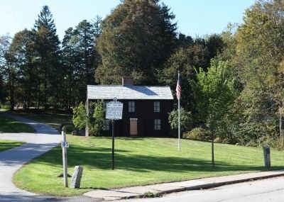
This house was built in 1694 by the Rev. John Hale, first minister of the first church in Beverly. A charge of witchcraft made against his wife convinced the minister of the folly and wickedness of the crusade and ended all witch-hunting in . . . — — Map (db m48760) HM
The old planters, Roger
Conant, John Woodbery and
John Balch used this path
from their homesteads to the
cove at the head of Bass river. — — Map (db m47401) HM
On Hobart Street at Centre Street, on the left when traveling west on Hobart Street.
To this church, rent by the witchcraft frenzy, came in 1697 the Reverend Joseph Green, aged twenty-two. He induced the mischief makers to confess, reconciled the factions, established the first public school, and became noted for his skill at . . . — — Map (db m48723) HM
A free school for Chebacco
parish was opened in an
upper room of this house in
1695 by the appointed master,
Nathaniel Rust, Junior. The town
gave "Six acres of pasture land
for the benefit of the school
and one-quarter acre for
Mr. Rust's . . . — — Map (db m47496) HM
On John Wise Avenue (Massachusetts Route 133), on the right when traveling north.
Erected in 1701 by John Wise, pastor of the Chebacco parish of Ipswich, now Essex. Son of a laborer, Harvard graduate, army chaplain, protestant against taxation without representation and against the witchcraft delusion, defender of democracy in . . . — — Map (db m47955) HM
On Main Street (Massachusetts Route 133), on the right when traveling north.
In 1668 the town granted the
adjacent acre of land "To the
inhabitants of Ipswich for a yard
to build vessels and to employ
workmen for that end."
The shipbuilding industry has
continued uninterruptedly in
Essex since that date. — — Map (db m47495) HM
On North Street, 0.2 miles north of Meadowview Road when traveling north.
Ten rods east stood the
house of Benjamin Goodrich
who, with his wife and two
children, was slain by the
Indians on October 23, 1692 — — Map (db m47864) HM
Here in 1630-31 a company from Plymouth, under Abraham Robinson, established a fishing station
and built curing stages. For nearly two centuries and a half Annisquam was a fishing and ship-building center. — — Map (db m48615) HM
On Rocky Neck Avenue, on the left when traveling south.
In September, 1606, Samuel de Champlain landed at Rocky Neck in what is now Gloucester Harbor, to caulk his shallop, and made an accurate chart of the harbor which he called Le Beauport. — — Map (db m48686) HM
On this site in 1623 the Dorchester Adventurers founded the nucleus of the Massachusetts Bay Colony, and fishing industry. Here Roger Conant averted bloodshed between two factions contending for a fishing stage, a notable example of arbitration in . . . — — Map (db m48614) HM
On Bay Road (Alternate Massachusetts Route 1), on the right when traveling south.
On December 3, 1787, the first covered wagon to leave
Massachusetts for the west
set forth from this spot
arriving the next spring in
the northwest territory and
founding Marietta, Ohio. — — Map (db m47272) HM
On Mill Street, 0.1 miles south of Hope Street, on the right when traveling south.
On this spot the Indians signed a deed granting Pentucket, now Haverhill, to the white settlers for three pounds ten shillings. The original deed dated November 15, 1642, is now in possession of the Haverhill Historical Society. — — Map (db m47862) HM
On Country Road (Massachusetts Route 133) at Ward Street, on the right when traveling north on Country Road.
Among the founders and early
residents of Ipswich - 1630 -
were John Winthrop, Junior,
scientist and industrial pioneer; Nathaniel Ward, lawmaker
and wit; Richard Bellingham
and Richard Saltonstall, magistrates who defended popular
rights; . . . — — Map (db m47556) HM
From the date of its settlement by John Winthrop and twelve associates, 1630, Agawam (Ipswich) was the seat of pillow lace making, by 1790 the annual production was 41,979 yards. This craft continued until the introduction of lace machinery. — — Map (db m47920) HM
Here on August 23, 1687,
the citizens of Ipswich, led by
the Reverend John Wise, denounced the levey of taxes by
the arbirary government of
Sir Edmund Andros, and from
their protest sprang the
American revolution of 1689 — — Map (db m47594) HM
On Broad Street (Massachusetts Route 1A) at Nahant Street, on the right when traveling west on Broad Street.
The Indian region called Saugus, settled 1629 by people from the Puritan colony at Salem, named for Lynn Regis in England, 1637. First place in North America to make boots and shoes for export. — — Map (db m48071) HM
On Orne Street at Fountain Inn Lane, on the right when traveling north on Orne Street.
Belonging to the Fountain Inn, where Sir Harry Frankland, collector of the Port of Boston, while supervising the erection of Fort Sewall, met Agnes Surriage in 1742. Agnes, a poor fisherman's daughter, later became Lady Frankland and returned with . . . — — Map (db m47951) HM
On Front Street at Fort Sewall Terrace, on the right when traveling north on Front Street.
Built in 1742 for defence (sic) against French cruisers. U.S.S. "Constitution" sought shelter under the fort's guns when chased by H.M.S. "Tenedos" and "Endymion" April 3, 1814. Named after Samuel Sewall of Marblehead, Chief Justice of . . . — — Map (db m47952) HM
On Orne Street at Pond Street, on the left when traveling north on Orne Street.
Established in 1638, one of the oldest graveyards in New England. Site of first meetinghouse. Six hundred Revolutionary heroes and several early pastors were interred at the top of the hill. — — Map (db m48005) HM
On High Street (Massachusetts Route 113) at High Street & Jefferson Street when traveling east on High Street.
First ferry across the Merrimack river from Newbury to Salisbury, established about 1639, and the only route from Boston to the eastern frontier. In 1641 George Carr was appointed ferryman with rights which continued in his family for generations. — — Map (db m47972) HM
On State Street at Prospect Street, on the right when traveling north on State Street.
Built in 1746 by Michael Dalton, later the residence of his son, Tristram Dalton, one of the first two United States Senators from Massachusetts. Here were entertained George Washington and
other distinguished men. — — Map (db m49452) HM
On High Street (Massachusetts Route 113), on the right when traveling east.
On this site dwelt Edward Rawson, secretary of the bay colony for thirty-six years, deputy to the General Court for twelve years, elected clerk of the House of Deputies in 1645, he died in Boston 1693. — — Map (db m47984) HM
Near this spot was "Watts Cellar," a landmark before the settlement of Newbury in 1635. An excavation used for the storage of fish by fishermen who visited the New England coast. — — Map (db m47985) HM
On Mt. Pleasant Street (Massachusetts Route 127A) at Main Street, on the right when traveling north on Mt. Pleasant Street.
Named from a bear caught by the tide and killed in 1700. Commercial and shipbuilding center of Rockport for 160 years. First dock built here 1743. Sandy Bay Pier Company organized 1809. Site of Stone Fort and Sea Fencibles Barrack during War of 1812. — — Map (db m48007) HM
On South Street, on the right when traveling north.
Answering a sudden alarm to meet at the house of Lieutenant Benjamin Tarr, grandson of Richard Tarr the first settler, sixty-six men from this village under Captain John Rowe, marched to Charlestown and fought in the Battle of Bunker Hill. — — Map (db m73109) HM
On Main Street at Highland Street, on the right when traveling south on Main Street.
Here stood the cabin of Richard Tarr founder of the Tarr Family on Cape Ann. He came to Marblehead in 1680, then settled in Sacco, Maine. Driven thence by Indians, he became the first settler of Sandy Bay (Rockport) in 1690. — — Map (db m48008) HM
On King Street at Smith Street, on the right when traveling north on King Street.
Here stood the first framed house in Sandy Bay (Rockport) built in 1700 by the second settler John Pool. He built the first sawmill, bridge and vessel in this settlement, and furnished the lumber used in building Long Wharf, Boston, in 1710. — — Map (db m48842) HM
On Beach Street, on the right when traveling south.
Original plot given by the first settler, Richard Tarr, who was buried here in 1732. Here lie most of the early settlers and many of the officers and soldiers of the French and Indian, Revolutionary and 1812 Wars. — — Map (db m48841) HM
Due east from here on July 16 1605 the Sieur De Monts sent Samuel De Champlain ashore to parley with some Indians. They danced for him and traced an outline map of Massachusetts Bay. These French explorers named this promontory, The Cape of Islands. — — Map (db m74709) HM
On Main Street (Alternate Massachusetts Route 1), on the right when traveling north.
The burial ground set apart at the settlement of the
town of Rowley in 1639. Here
are buried Ezekiel Rogers,
Samuel Phillips, Samuel
Shepard, Edward Payson and Jedediah Jewett, the earliest
ministers of the town, and
nearly all the original . . . — — Map (db m115314) HM
On Elm Street (Massachusetts Route 110) at Mudnock Road, on the right when traveling east on Elm Street.
Site of the first meetinghouse built
on the open green in 1640. The bell, hung in 1642, is said to have been brought from England by order of the Reverend William Worcester, who settled here in 1639. — — Map (db m48121) HM
On Lafayette Rd. at Beach Rd., on the right when traveling north on Lafayette Rd..
Near by stood the house built in 1639 by Robert Pike, a leader in civil and military affairs who represented Salisbury for thirty-seven years in the general court. — — Map (db m75590) HM
On Lafayette Road (U.S. !) 0.2 miles Pike Street (Massachusetts Route 286).
Early name Colchester settled in 1638. Name changed to Salisbury in 1640 in compliment to its Puritan clergyman William Worcester of Salisbury, England. — — Map (db m77223) HM
On Appleton Street, 0.2 miles west of Central Street, on the right when traveling west.
In 1687 Major Appleton of Ipswich made a speech on this rock denouncing the tyranny of the Royal Governor, Sir Edmund Andros. A watch was stationed on the hill to give warning of any approach of the Crown Officers. — — Map (db m48112) HM
On Central Street, on the right when traveling south. Reported missing.
"The Company of Undertakers for the Iron Works," consisting of English gentlemen and colonists, erected a furnace on this site in 1643. Joseph Jenks, their employe, built a forge here in 1647, invented the modern type of scythe, and built Boston's . . . — — Map (db m48222) HM
On Howard Street west of Main Street, on the right when traveling west. Reported missing.
Erected in 1650 or 1651 by The Undertakers of the Iron Works in Lynn (Saugus) to house Scotch prisoners captured by Cromwell at the Battle of Dunbar and sold into seven years' service in New England as indentured servants. — — Map (db m50198) HM
On Main Street (Alternate State Highway 1), on the right when traveling west.
Settled about 1636, called
Enon "Because there was much
water there" (St. John III, 23).
Set off from Salem and name
changed to Wenham 1643 — — Map (db m47221) HM
Settled about 1636, called Enon, "Because there was much water there" (St. John III, 23). Set off from Salem and name changed to Wenham 1643. — — Map (db m48728) HM
On Bernardston Road (U.S. 5), on the right when traveling north.
Six rods easterly stood Burke Fort the first and largest, and also the first building in Fall Town. Built in 1738/39 by John Burke it was six rods square and contained eight houses. Fifty persons took shelter here during the old French and Indian . . . — — Map (db m48254) HM
On Brattleboro Road (U.S. 5), on the left when traveling north.
Site of the second fort and building in Fall Town, erected in 1739 by Samuel Connable. Its original timbers are still in the house on a knoll to the northwest. — — Map (db m48774) HM
On Huckle Hill Road close to West Road, on the right when traveling north.
The Lieutenant's son Ebenezer, later deacon of the church and first town treasurer, built a fort ten rods east of here in 1740/41. It was unsuccessfully attacked by Indians in 1746 during King
George's War. — — Map (db m48777) HM
On Northfield Road (U.S. 10), on the right when traveling west.
Built in 1740 on this site. The first Proprietor's Meeting in Fall Town was held here in 1741. The Lieutenant's son Eliakim was shot by Indians in 1747 while working west of the fort walls. — — Map (db m48011) HM
On Greenfield Road (U.S. 5) north of Main Street, on the right when traveling north.
Indian land called Pocomtuck, settled by men from Dedham in 1671. Attacked by Indians, burnt, and abandoned in 1675. Reoccupied and attacked in 1704 by French and Indians, who took 47 lives, and carried off 112 captives to Canada, of whom 60 were . . . — — Map (db m48012) HM
On Old Main Street near Wells Street, on the left when traveling north.
Indian land called Pocomtuck, settled by men from Dedham in 1671. Attacked by Indians, burnt, and abandoned in 1675. Reoccupied and attacked in 1704 by French and Indians, who took 47 lives, and carried off 112 captives to Canada, of whom 60 were . . . — — Map (db m48773) HM
On Eunice Williams Drive, 0.5 miles Leyden Road, on the left when traveling west.
Eunice Williams, wife of the Reverend John Williams "The Redeemed Captive," was killed at this place on March 1, 1704, during the Deerfield massacre. — — Map (db m29069) HM
On Millers Falls Road (Massachusetts Route 63) close to Homer Road, on the right when traveling north.
Two hundred and fifty yards eastward are the sites of three large Indian council fires. The Beers Massacre of September 4, 1675, took place in a gorge one-quarter mile to the northeast. — — Map (db m48780) HM
On Old Bernardston Road, on the left when traveling east.
Philip, second son and successor of Massasoit, Sachem of the Wampanoag, camped on this hill during the winter of 1675-6. The stump of a large look-out tree together with defence trenches are to be seen on top. — — Map (db m48778) HM
Nathaniel Dickinson lived here nineteen years in a fortified house but was scalped and killed by the Indians on April 15, 1747, at Pachaug Hill. — — Map (db m42634) HM
On Main Street (U.S. 10) close to Maple Street, on the left when traveling north.
Here, enclosed by a stockade, the first settlement was made in 1673. Nine rods to the westward a fort was built in 1685 and eight rods southeast stood the Indians' Council Rock. — — Map (db m48015) HM
On U.S. 20 close to Warren Road (Massachusetts Route 19), on the left when traveling east.
Two miles distant on Indian Hill is the site of an Indian stronghold and storehouse for corn, Quaboag Old Fort, and of the Indian village of Ashquoach. — — Map (db m48776) HM
On U.S. 20 at Warren Road (Massachusetts Route 19) on U.S. 20.
Four miles distant on the summit of East Waddaquodduck Mountain is Steerage Rock, a landmark on the Indian trail which became known as the Bay Path and a guidepost to the pioneer settlers of the Connecticut Valley from
Massachusetts Bay in 1636. — — Map (db m88553) HM
On North Lane (Massachusetts Route 9) south of Cemetery Road, on the right when traveling south.
Indian land called Norwottock. Settled in 1650 by families from Hartford. The Regicides Generals Goffe and Whalley were concealed for fifteen years in the Pastor's house. — — Map (db m48174) HM
On Russell Street (Massachusetts Route 9), on the right when traveling east.
Indian land called Norwottock. Settled in 1650 by families from Hartford. The Regicides Generals Goffe and Whalley were concealed for fifteen years in the Pastor's house. — — Map (db m48757) HM
On Carlisle Road, 0.6 miles north of Main Street (Massachusetts Route 27), on the left when traveling east.
Here was the home of Captain John Heald, first selectman of Acton, who on April 19, 1689, marched to Boston with a military company to assist in the overthrow of Sir Edmund Andros. — — Map (db m48826) HM
On Alcott Street, 0.2 miles south of Concord Road.
Site of first house in Acton, built by Captain Thomas Wheeler in 1668. He was commissioned to keep fifty cattle for the inhabitants and at night protect them in a yard from wild beasts. He was wounded by the Indians in King Philip's War. — — Map (db m48823) HM
On Jason Street, on the right when traveling south.
Built by Martha, widow of William Russell, about 1680. Occupied until 1890 by her descendants, of whom Jason Russell lost his life in the conflict of April 19, 1775. — — Map (db m43052) HM
Site of homestead of Captain Jonathan Danforth, pioneer of Billerica and famous surveyor. "He rode
the circuit, chain'd great towns and farms to good behavior; and by well worked stations he fixed their bounds for many generations. " — — Map (db m104020) HM
On Billerica Avenue just north of Hickory Lane, on the right when traveling north.
Near this spot stood the John Rogers homestead, which was destroyed in the Indian massacre of 1695, and the entire family killed. — — Map (db m48838) HM
On Massachusetts Avenue at Dunster Street, on the right when traveling south on Massachusetts Avenue.
Location chosen in 1630 to be the capital of the Massachusetts Bay Colony. Settled in 1631 under leadership of Thomas Dudley and called the New Town. The College ordered to be here, 1637. Name changed to Cambridge after the English University Town, . . . — — Map (db m48824) HM
On Massachusetts Avenue (Massachusetts Route 2A) at Linnaean Street, on the right when traveling south on Massachusetts Avenue.
At Number 21 Linnaean Street is the Cooper-Austin House built in 1657 at what was then the northern end of the Cambridge Cow Common, by John Cooper, selectman, town clerk, and deacon of the church. — — Map (db m43049) HM
Washington Street, Somerville, and Kirkland and Brattle Streets, Cambridge, "Skirting marshes and river," follow the old Indian trail from Charlestown to Watertown. Along this way in 1636 went the Reverend Thomas Hooker and his congregation on their . . . — — Map (db m48017) HM
On Mount Auburn Street at Fresh Pond Parkway (Massachusetts Route 2) on Mount Auburn Street.
Here at the river's edge the settlers of Watertown led by Sir Richard Saltonstall landed in June 1630. Later this spot became known as Gerry's Landing, for Elbridge Gerry, signer of the Declaration of Independence and Governor of Massachusetts who . . . — — Map (db m48016) HM
On Monument Sq (Massachusetts Route 62) at Main Street, on the right when traveling south on Monument Sq.
Near this spot stood the ancient oak known as Jethro’s Tree beneath which Major Simon Willard and his associates bought from the Indians the “6 myles of land square” ordered by the General Court for the Plantation of Concord September . . . — — Map (db m18169) HM
On Main Street (Massachusetts Route 62), on the right when traveling south.
This short stretch of street still known as the milldam was the site of an Indian fishing weir and was laid out along the dam built soon after the settlement of the town in 1635. — — Map (db m18170) HM
On Kendall Road (Massachusetts Route 113), on the right when traveling west.
Settled before 1673, a town in 1680, divided by the New Hampshire – Massachusetts boundary, the northern part becoming Nashua, New Hampshire in 1741. — — Map (db m43413) HM
On Pleasant Street (Massachusetts Route 113), on the right when traveling east.
Settled before 1673, a town in 1680, divided by the New Hampshire – Massachusetts boundary, the northern part becoming Nashua, New Hampshire in 1741. — — Map (db m43415) HM
On Belknap Street at Grove Street, on the right when traveling east on Belknap Street.
Built in 1693 by Jeremiah Pike. He and his descendants were town and militia officers, yeomen and makers of spinning wheels, in the colonial period. This house has been occupied by the same family for eight generations. — — Map (db m48805) HM
On Main Street (Massachusetts Route 119), on the left when traveling south.
Settled as a frontier town in 1655 in the Indian region called Petapawag. When attacked by Indians of King Philip in 1676 all houses but four were burned, and the town was temporarily abandoned. Again attacked in 1689, 1704 and 1723. — — Map (db m48822) HM
On Main Street (Massachusetts Route 119), on the left when traveling south.
Near by stood a garrison house, residence of Captain James Parker, Commander of the town forces in King Philip's War. Here Captain Parker parleyed with the Indian Chief John Monoco regarding his threat to burn Groton and Boston, March 13, 1676. — — Map (db m48821) HM
On Summer Street at Favor Street, on the right when traveling west on Summer Street.
Site of chapel erected in 1653 for John Eliot, the Apostle to the Indians. Here he preached to the Wamesit and Pennacook Indians, converting many and establishing a village of Christian Indians called Wamesit. — — Map (db m122299) HM
On Pawtucket Blvd at Island Road on Pawtucket Blvd.
On Wickasee Island (now Tyngs Island) in the Merrimac dwelt Wannalancet, last sachem of the Pennacook Confederacy, and like his father Passaconway, a faithful friend to the English. — — Map (db m48022) HM
On Lakeside Ave (Massachusetts Route 20) at Williams Street, on the right when traveling east on Lakeside Ave.
The first tavern was erected on this site by Lieutenant Abraham Williams in 1665. Destroyed by Indians in 1676, it was promptly rebuilt and managed by the Williams Family until 1829. Here the early Circuit Courts convened, stage coaches changed . . . — — Map (db m48023) HM
Mansion built by Isaac Royall who came here from Antigua with his slaves in 1737. His son Isaac Royall, a loyalist, founded at Harvard the oldest law professorship in the United States. Headquarters of General John Stark during the Siege of Boston. — — Map (db m50420) HM
On Eliot Street (Massachusetts Route 16) at Union Street, on the left when traveling north on Eliot Street.
On this site John Eliot helped his Indian converts to build their first meetinghouse in 1651, with a "prophet's chamber" where he lodged on his fortnightly visits to preach to them in their language. His disciple Daniel Takawambait succeeded to the . . . — — Map (db m48806) HM
On Center Street close to Cotton Street, on the right when traveling north.
The original meetinghouse of the First Church in Newton was built in this burying ground in 1660. The first pastor was John Eliot, Jr., son of the Apostle to the Indians. — — Map (db m48820) HM
On Main Street (Route 28) at Washington Street, on the right when traveling south on Main Street.
One-eighth of a mile to "the
simple home of an ordinary man,
not wealthy, not particularly
distinguished, but a type of the
God-fearing yeomanry .... as
Ephraim Parker left it, it
remains today an unchanged
relic in the midst of a . . . — — Map (db m48840) HM
On Phoneix Street, 0.1 miles south of Front Street (Local Route .1), on the left when traveling west.
The house of the first minister of Shirley, Phinehas Whitney. Dorothy Quincy and Madam Lydia Hancock visited here; and here also in 1773 came John Hancock to accompany them home. Moved to this site in 1906 it became the Rectory of St. Anthony's . . . — — Map (db m48809) HM
On Massachusetts Route 2A near Parker Road, on the right when traveling west.
Built before 1747 and kept from 1758 to 1790 by Obadiah Sawtell, "the old landlord." He was a delegate to the Provincial Congress. Here the men gathered at the alarm on April 19, 1775. — — Map (db m48815) HM
This stone windmill built by John Mallet about 1703 was sold to the Province for a gun powder magazine in 1747. Rifled by General Gage of the Colony's powder on I September 1774, it became a magazine of the American Army in 1775-76. — — Map (db m48827) HM