244 entries match your criteria. The first 100 are listed. ⊳
Erie Canal Historical Markers
By Howard C. Ohlhous, October 27
The Erie Canal / Albany Basin Marker
| 1 ► New York, Albany County, Albany — The Erie Canal / Albany Basin — |
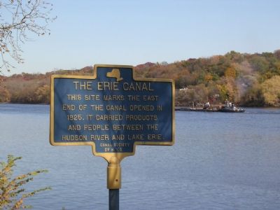
| 2 ► New York, Albany County, Albany, Downtown — Erie Canal — |
| 3 ► New York, Albany County, Cohoes — Juncta — |
| On Saratoga Street (New York State Route 32), on the right when traveling north. | |||
| 4 ► New York, Albany County, Cohoes — The Erie Canal — Power Canal Park | Cohoes NY — |
| Near North Mohawk Street, on the right when traveling south. | |||
| 5 ► New York, Albany County, Colonie — Maplewood Historic Park — |
| On 2nd Avenue (New York State Route 32) north of 26th Street, on the right when traveling north. | |||
| 6 ► New York, Albany County, Colonie — The Erie Canal — |
| On Broadway (New York State Route 32) near Federal Express Plaza, on the right when traveling north. | |||
| 7 ► New York, Albany County, Colonie — The Weighlock Building — 1850-1915 — |
| On 2nd Avenue (New York State Route 32) north of 26th Street, on the right when traveling north. | |||
| 8 ► New York, Albany County, Watervliet — Erie Canal — |
| On 2nd Avenue (New York State Route 32) at 23rd Street, on the right when traveling north on 2nd Avenue. | |||
| 9 ► New York, Bronx County, Bronx, Mott Haven — Gouverneur Morris — |
| On Saint Ann's Avenue just north of La Lupe Way, on the right when traveling south. | |||
| 10 ► New York, Cayuga County, Brutus — Conduit For Ideas — The Canalway Trail — |
| Near New York State Route 31 at West Brutus Street. | |||
| 11 ► New York, Cayuga County, Brutus — The Boom Years — The Canalway Trail — |
| Near New York State Route 31 at West Brutus Street. | |||
| 12 ► New York, Cayuga County, Brutus — The Erie Canal — The Centreport Aqueduct — Centreport Aqueduct Park — |
| Near New York State Route 31 at West Brutus Street. | |||
| 13 ► New York, Cayuga County, Brutus — The Erie Canal — Historic New York — |
| On New York State Route 31 at West Brutus Street, on the right when traveling east on State Route 31. | |||
| 14 ► New York, Cayuga County, Montezuma — A Landmark and Pride in Our Community — Byron Lapp Memorial Trail and Montezuma Heritage Park — |
| On High Street, 0.1 miles north of Erie Street, on the left when traveling north. | |||
| 15 ► New York, Cayuga County, Montezuma — Early Aqueduct — |
| On Chapman Road, 0.3 miles west of High Street, on the right when traveling south. | |||
| 16 ► New York, Cayuga County, Montezuma — Montezuma Heritage Park — Mural & Historic Markers Dedication — May 4, 2013 — |
| Near High Street, 0.1 miles north of Erie Street. | |||
| 17 ► New York, Cayuga County, Montezuma — Old Erie Canal — |
| On New York State Route 90 at Erie Street, on the right when traveling north on State Route 90. | |||
| 18 ► New York, Cayuga County, Montezuma — Opened in 1828 — Cayuga Seneca Canal — |
| On High Street at Erie Street, on the left when traveling north on High Street. | |||
| 19 ► New York, Cayuga County, Port Byron — A Metaphor for Change — The Canalway Trail — |
| Near Utica Street (New York State Route 31) 0.3 miles east of Main Street (New York State Route 38). | |||
| 20 ► New York, Cayuga County, Port Byron — Blacksmith Shop and Mule Shed — Port Byron / Old Erie Canal Heritage Park — |
| Near Interstate 90. | |||
| 21 ► New York, Cayuga County, Port Byron — Glaciers, Drumlins, and High Level Lakes — Port Byron / Old Erie Canal Heritage Park — |
| Near Interstate 90. | |||
| 22 ► New York, Cayuga County, Port Byron — Port Byron's Lock 52 — |
| Near Interstate 90. | |||
| 23 ► New York, Cayuga County, Port Byron — Tanner's Dry Dock — The Canalway Trail — |
| Near Utica Street (New York State Route 31) 0.3 miles east of Main Street (New York State Route 38). | |||
| 24 ► New York, Cayuga County, Port Byron — Tanner's Dry Dock — |
| Near Interstate 90. | |||
| 25 ► New York, Cayuga County, Port Byron — The Erie Canal — Historic New York — |
| Near New York Thruway (Interstate 90) 25.4 miles east of Ridge Road (New York State Route 414), on the right when traveling east. | |||
| 26 ► New York, Cayuga County, Port Byron — The Erie Canal in Port Byron — Erie Canal Heritage Park at Port Byron — Today's Canal System in New York — |
| Near Interstate 90. | |||
| 27 ► New York, Cayuga County, Port Byron — The Erie House — Port Byron / Old Erie Canal Heritage Park — |
| Near Interstate 90 near Erie Canal Heritage Site. | |||
| 28 ► New York, Chemung County, Chemung — Junction Canal — |
| On Wyncoop Creek Road (County Road 3) just south of Main Street (County Road 60), on the right when traveling south. | |||
| 29 ► New York, Chemung County, Elmira — Chemung Canal — |
| On East Water Street (State Highway 352) at Clemens Center Parkway (State Highway 14), on the right when traveling east on East Water Street. | |||
| 30 ► New York, Erie County, Amherst — A Dam on Tonawanda Creek — The Canalway Trail: Amherst — |
| Near Creekside Drive, 0.1 miles west of Old Niagara Falls Boulevard. | |||
| 31 ► New York, Erie County, Amherst — The Erie Canal at Amherst — Erie Canalway Trail - Amherst — |
| On Tonawanda Creek Road at New Road, on the right when traveling west on Tonawanda Creek Road. | |||
| 32 ► New York, Erie County, Angola — Western New York — Historic New York — |
| On New York State Thruway / AMVETS Memorial Highway (Interstate 90 at milepost 443). | |||
| 33 ► New York, Erie County, Buffalo — "The Black Rock" |
| On Black Rock Harbor Road, 0.2 miles west of Niagara Street (New York State Route 266), on the left when traveling west. Reported missing. | |||
| 34 ► New York, Erie County, Buffalo, Black Rock — Black Rock — |
| On Amherst Street at Niagara Street (New York State Route 266), on the left when traveling east on Amherst Street. | |||
| 35 ► New York, Erie County, Buffalo, Black Rock — Black Rock Harbor — June 1823 — |
| On Amherst Street east of Niagara Street (New York State Route 266), on the left when traveling east. | |||
| 36 ► New York, Erie County, Buffalo, Black Rock — Tow Path Park — |
| On Hertel Avenue, 0.2 miles west of Niagara Street (New York State Route 266), on the left when traveling east. | |||
| 37 ► New York, Erie County, Buffalo, Downtown — From Frontier to Major City / Buffalo City Hall — Buffalo History and Architecture — Niagara Square West — |
| Near Niagara Square at Niagara Street. | |||
| 38 ► New York, Erie County, Buffalo, Downtown — Our Legacy of Abundant Water — Buffalo History and Architecture — Niagara Square South — |
| Near Niagara Square at Delaware Avenue, in the median. | |||
| 39 ► New York, Erie County, Buffalo, First Ward — Lighthouse Point Park — |
| On Fuhrmann Boulevard, 1.2 miles north of The Skyway (New York State Route 5), on the right when traveling north. | |||
| 40 ► New York, Erie County, Buffalo, First Ward — The Early Grain Trade / Influence of the Erie Canal — The Industrial Heritage Trail — |
| On Fuhrmann Boulevard, 0.2 miles south of The Skyway (New York State Route 5), on the left when traveling north. | |||
| 41 ► New York, Erie County, Buffalo, First Ward — The Engineers of the Grain Elevators — The Industrial Heritage Trail — |
| On Fuhrmann Boulevard, 0.2 miles south of The Skyway (New York State Route 5), on the right when traveling south. | |||
| 42 ► New York, Erie County, Buffalo, First Ward — The First Grain Elevator / Early Grain Elevators — The Industrial Heritage Trail — |
| On Fuhrmann Boulevard, 0.2 miles south of The Skyway (New York State Route 5), on the right when traveling south. | |||
| 43 ► New York, Erie County, Buffalo, First Ward — The Grain Industry Decline / Buffalo's Grain Legacy — The Industrial Heritage Trail — |
| On Fuhrmann Boulevard, 0.2 miles south of The Skyway (New York State Route 5), on the right when traveling south. | |||
| 44 ► New York, Erie County, Buffalo, Riverside — Hunting and Fishing off the Porch — |
| On Niagara Street (Route 266) at Collaton Street, on the right when traveling south on Niagara Street. | |||
| 45 ► New York, Erie County, Buffalo, South Park — Improvements in Ship Design — The Industrial Heritage Trail — |
| On Fuhrmann Boulevard, 0.2 miles south of Ohio Street, on the left when traveling north. | |||
| 46 ► New York, Erie County, Buffalo, Waterfront — A Changing Waterfront — |
| On Marine Drive at Commercial Street, on the right when traveling east on Marine Drive. | |||
| 47 ► New York, Erie County, Buffalo, Waterfront — Buffalo - A Network of Canals — Sail Lofts, Stables, Grain Elevators, Brothels, Saloons — |
| On Lloyd Street at Marine Drive, on the right when traveling south on Lloyd Street. | |||
| 48 ► New York, Erie County, Buffalo, Waterfront — Buffalo - An Industrial Powerhouse — Tanneries, Clothiers, Piano Makers, Saddlers and Breweries — |
| On Lloyd Street at Marine Drive, on the right when traveling south on Lloyd Street. | |||
| 49 ► New York, Erie County, Buffalo, Waterfront — Buffalo - Queen City of the Lakes — Erie Canalway National Heritage Corridor — |
| Near Marine Drive at Commercial Street. | |||
| 50 ► New York, Erie County, Buffalo, Waterfront — Buffalo Riverfront Historical Eras to 1930 — |
| On Marine Drive at Commercial Street, on the left when traveling west on Marine Drive. | |||
| 51 ► New York, Erie County, Buffalo, Waterfront — Buffalo's Birthplace — Where the Erie Canal Joins the Commercial Slip — |
| On Commercial Street at Perry Boulevard, on the left when traveling south on Commercial Street. | |||
| 52 ► New York, Erie County, Buffalo, Waterfront — Canal and Harbor — Transforming Buffalo — |
| Near Marine Drive, 0.1 miles north of Lloyd Street, on the right when traveling west. | |||
| 53 ► New York, Erie County, Buffalo, Waterfront — Erie Canalway National Heritage Corridor — |
| On Marine Drive at Commercial Street, on the right when traveling east on Marine Drive. | |||
| 54 ► New York, Erie County, Buffalo, Waterfront — Harboring Hopes — |
| On Lloyd Street at Prime Street, on the left when traveling east on Lloyd Street. | |||
| 55 ► New York, Erie County, Buffalo, Waterfront — Rebirth & Renewal — |
| On Prime Street at Lloyd Street, on the left when traveling north on Prime Street. | |||
| 56 ► New York, Erie County, Buffalo, Waterfront — The Big Picture — |
| On Lloyd Street at Marine Drive, on the right when traveling south on Lloyd Street. | |||
| 57 ► New York, Erie County, Buffalo, Waterfront — The Erie Canal / Two Waterfronts — |
| On Prime Street at Lloyd Street, on the left when traveling north on Prime Street. | |||
| 58 ► New York, Erie County, Buffalo, Waterfront — The Grand Canal — |
| On Marine Drive at Commercial Street, on the left when traveling west on Marine Drive. | |||
| 59 ► New York, Erie County, Buffalo, Waterfront — The Immigrant Steps — Building Buffalo — |
| Near Commercial Street at Perry Boulevard, on the right when traveling north. | |||
| 60 ► New York, Erie County, Buffalo, Waterfront — The Industrial Heritage Trail — Monuments to the Movement of Grain — Maritime Heritage — |
| Near Erie Street, 0.1 miles west of Marine Drive. | |||
| 61 ► New York, Erie County, Buffalo, Waterfront — The Ruins at Canalside — Drinking in 19th Century Buffalo — |
| On Lloyd Street, 0.1 miles north of Prime Street, on the right when traveling south. | |||
| 62 ► New York, Erie County, Buffalo, Waterfront — Wedding of the Waters — The Completion of the Erie Canal — |
| Near Marine Drive at Pearl Street. | |||
| 63 ► New York, Erie County, Clarence — Niagara Frontier — Historic New York — |
| Near Governor Thomas E. Dewey Thruway (Interstate 90 at milepost 412), 10.6 miles west of Alleghany Road (New York State Route 77), on the right when traveling west. | |||
| 64 ► New York, Erie County, Grand Island — Strawberry Island — Past to Present — |
| On Park Road Loop at Area 3, on the right when traveling east. | |||
| 65 ► New York, Erie County, Tonawanda — City of Tonawanda — A Community Built Around Lumber — |
| On East Main Street at Longs Avenue, on the right when traveling west on East Main Street. | |||
| 66 ► New York, Erie County, Tonawanda — Engineering the Erie Canal — |
| Near Niagara Street (New York State Route 266) 0.1 miles north of Gibson Street. | |||
| 67 ► New York, Erie County, Tonawanda — Erie Canal Site — |
| 68 ► New York, Erie County, Tonawanda — Gastown — Erie Canalway Trail — |
| On East Niagara Street at East Avenue, on the right when traveling west on East Niagara Street. | |||
| 69 ► New York, Erie County, Tonawanda — Gateway to the West — |
| On Main Street at Young Street when traveling north on Main Street. | |||
| 70 ► New York, Erie County, Tonawanda — Lumber Capital — |
| On Young Street at Main Street, on the right when traveling west on Young Street. | |||
| 71 ► New York, Erie County, Tonawanda — The Dam — |
| On Young Street at Main Street, on the right on Young Street. | |||
| 72 ► New York, Erie County, Tonawanda — The Long Homestead — |
| Near East Niagara Street, 0.1 miles west of Fillmore Avenue. | |||
| 73 ► New York, Erie County, Tonawanda — The People — Erie Canalway Trail — |
| On East Niagara Street at Longs Avenue, on the right when traveling west on East Niagara Street. | |||
| 74 ► New York, Erie County, Tonawanda — The Railroad — |
| On Young Street at Main Street, on the left when traveling east on Young Street. | |||
| 75 ► New York, Erie County, Tonawanda — Westward to Buffalo — Niagara River Greenway — |
| Near Niagara Street (New York State Route 266) 0.2 miles west of Veterans Road. | |||
| 76 ► New York, Herkimer County, Little Falls — A Bridge for Boats — The Little Falls Aqueduct — |
| On Mohawk Street, on the left when traveling south on Mohawk Street. | |||
| 77 ► New York, Herkimer County, Little Falls — Herkimer Little-Falls Area — Historic New York — |
| On Interstate 90, 1 mile east of New York State Route 169, on the right when traveling east. | |||
| 78 ► New York, Herkimer County, Little Falls — Little Falls — Water Power for Sale/A Valley Corridor/Historic Sites and Community Services — |
| On MoHawk Street at South Ann Street, on the right when traveling east on MoHawk Street. | |||
| 79 ► New York, Kings County, Brooklyn, Greenwood Heights — Governor DeWitt Clinton — |
| On Bayside Avenue. | |||
| 80 ► New York, Livingston County, Nunda — Lock 42 — |
| On North State Street (New York State Route 408) at 4th Street on North State Street. | |||
| 81 ► New York, Madison County, Canastota — Enlarging the Erie Canal — Erie Canalway National Heritage Corridor — |
| On Canal Street (County Route 76) at Commerce Street, on the left when traveling west on Canal Street. | |||
| 82 ► New York, Madison County, Canastota — The Erie Canal — Historic New York — |
| On NYS Thruway (U.S. 90) 4 miles west of N Peterboro Street (New York State Route 13). | |||
| 83 ► New York, Madison County, Chittenango — Canal Industry — |
| On Lakeport Road (County Route 3) north of Clay Hill Road, on the left when traveling north. | |||
| 84 ► New York, Monroe County, Brighton — Route of Original Erie Canal — |
| On Monroe Avenue (New York State Route 31) 0.1 miles north of Allens Creek Road, on the right when traveling west. | |||
| 85 ► New York, Monroe County, Brockport — Brockport and the Canal — |
| On Main Street (New York State Route 19), on the right when traveling north. | |||
| 86 ► New York, Monroe County, Brockport — Canal Commerce in Brockport — Luther Gordon, the spirit of canal commerce in Brockport — |
| On Main Street (New York State Route 19) at the south end of the Erie Canal drawbridge, on the right when traveling north on Main Street. | |||
| 87 ► New York, Monroe County, Bushnell's Basin — Bushnell's Basin — |
| On Marsh Road at Pittsford-Victor Rd. (New York State Route 96), on the right when traveling south on Marsh Road. | |||
| 88 ► New York, Monroe County, Bushnell's Basin — Richardson Tavern — |
| On Marsh Road at Pittsford-Victor Rd., on the right when traveling west on Marsh Road. | |||
| 89 ► New York, Monroe County, Fairport — Fullam's Basin — |
| On West Church Street (New York State Route 31F) 0.2 miles east of O'Connor Road, on the right when traveling west. | |||
| 90 ► New York, Monroe County, Fairport — New York State Canals — The Great American Canal — |
| Near O'Connor Road. | |||
| 91 ► New York, Monroe County, Fairport — Old Erie Canal — 1825-1975 — |
| Near South Main Street (New York State Route 250) just east of West Ave.. | |||
| 92 ► New York, Monroe County, Greece — Henpeck — |
| On Ridgeway Avenue, 0.2 miles south of Elmgrove Road. | |||
| 93 ► New York, Monroe County, Henrietta — The Great American Canal — The Canal System — |
| Near Edgewood Avenue (County Route 102) 0.2 miles south of French Road. | |||
| 94 ► New York, Monroe County, Pittsford — Building the Great Embankment — |
| Near Marsh Road (New York State Route 38) north of Falling Creek Road, on the left when traveling north. | |||
| 95 ► New York, Monroe County, Pittsford — Cartersville — |
| On East Street just south of East Jefferson Road (New York State Route 96), on the right when traveling south. | |||
| 96 ► New York, Monroe County, Pittsford — Changing Alignments — The Canalway Trail: Pittsford — |
| Near Clover Street, 0.2 miles west of Framingham Lane. | |||
| 97 ► New York, Monroe County, Pittsford — Erie Canal — Albany to Buffalo — |
| On North Main Street, 0.2 miles Monroe Avenue, on the right when traveling north. | |||
| 98 ► New York, Monroe County, Pittsford — Erie Canal — Heritage Trail — |
| Near Marsh Road. | |||
| 99 ► New York, Monroe County, Pittsford — Historic Schoen Place — |
| On Schoen Place, 0.1 miles north of State Street (New York State Route 31), on the left when traveling north. | |||
| 100 ► New York, Monroe County, Pittsford — Phoenix Hotel — |
| On State Street (New York State Route 31) at S. Main Street (New York State Route 96) on State Street. | |||
244 entries matched your criteria. The first 100 are listed above. Next 100 ⊳