On Main Street at Hunter Street, on the left when traveling north on Main Street.
After their victory at Wilson's Creek, on Aug. 10, 1861, Gen. Sterling Price's 12,000 Missouri State Guards marched north and camped near Nevada on the evening of Aug. 31. Next day 800 men felt out the 1800 Federals at Ft. Scott, Kan., led by . . . — — Map (db m36022) HM
While Confederate Brigadier General H. H. Sibley was assembling the bulk of his army at Santa Fe, Union Colonel E.R.S. Canby moved 1200 men from Fort Craig to occupy Albuquerque – "If it can be done without serious loss." Though outnumbered . . . — — Map (db m45270) HM
On North Main Street at Webb Avenue (North Carolina Highway 87) on North Main Street.
At this site on 1 June 1861 soldiers of the 6th NC State Troops, commanded by Col. Charles Fisher president of the NC Railroad, drilled before departing for the war front. In July 1861, they became the first troops ever carried by rail into battle. . . . — — Map (db m29626) HM
On Fort Macon Road, on the right when traveling east.
This cannon is a replica of a rifled Model 1841 Navy 32-pounder which stood here in the War Between the States. The cannon was originally a smoothbore 32-pounder and fired a round 32-pound cannonball. In October, 1861, Confederate soldiers converted . . . — — Map (db m31536) HM
On Dobbin Avenue when traveling west. Reported permanently removed.
The Women of Cumberland
to their
Confederate Dead
May 20, 1861 - May 10, 1902
They died in defence of their
RightsFor they should fall the tears
of a nation's grief.Lord God of Hosts be with us yet, . . . — — Map (db m31143) HM
On South Main Street at Tanyard Lane, on the right when traveling south on South Main Street.
300 yards Northwest of this marker, near the creek branch, stood a tannery begun by John Frederick and Philip Kerner, two sons of Joseph Kerner for who the town was named. During the War between the States (1861-1865) the tannery was operated by . . . — — Map (db m54129) HM
On S Davie Street at E McGee Street, on the right when traveling north on S Davie Street. Reported permanently removed.
The Tarpley breech-loading carbine was manufactured by Tarpley, Garrett & Co. at the site of the old Pioneer Foundry, located 300 yards east. Jere A. Tarpley received a patent from the Confederate Government for the carbine on February 14, 1863. In . . . — — Map (db m219619) HM
On Martin Luther King Junior Drive at East McGee Street, on the left when traveling south on Martin Luther King Junior Drive. Reported permanently removed.
To the memory of the men of Greensboro and Guilford County, who fought for North Carolina and the Confederacy in the War for Southern Independence. 1861 - 1865 These while in the prime of life, fought, bled and died; walking in the steps of . . . — — Map (db m219616) HM
On Martin Luther King Junior Drive at East McGee Street, on the left when traveling south on Martin Luther King Junior Drive. Reported permanently removed.
They are all gone now with their tattered flags and their faded uniforms. Shiloh, Perryville, Murfreesboro, Chickamauga, Lookout Mountain, Missionary Ridge, Resaca, Kennesaw Mountain, Peachtree Creek, Atlanta, Ezra Church, Jonesboro, Franklin, . . . — — Map (db m221878) HM
On N Main Street (U.S. 311 Bus) at E English Road, on the left when traveling south on N Main Street.
Located ¾ mile east, Camp Fisher was a camp of instruction for North Carolina troops in 1861 – 1862. Camp Fisher was named for Col. Charles Fisher of Salisbury, after his death at the battle of First Manassas. — — Map (db m34039) HM
On N Main Street (U.S. 311 Bus), on the right when traveling north.
The Gillam & Miller Gun Factory was located here. Owned by Dr. L. M. Gillam and James Miller, the firm manufactured rifles and gun stocks for the state of North Carolina in 1863. The firm also had a contract to sell rifles to the Confederate . . . — — Map (db m34033) HM
On Penny Road at East Fork Road, on the right when traveling north on Penny Road.
The North Carolina Armory at Florence, was located ¼ east. Commanded by Captain Z.S. Coffin, the armory converted hunting rifles into military arms, repaired broken guns, and assembled new guns between 1862 and 1865. On April 11, 1865, a detachment . . . — — Map (db m216816) HM
On Oakdale Road at Harvey Road, on the right when traveling south on Oakdale Road.
The Mendenhall, Jones, and Gardner gun factory was located 200 yards west. Owned by Cyrus P. Mendenhall, Ezekial Jones, and Grafton Gardner, the firm produced approximately 2,000 rifles for the state of North Carolina at this location from . . . — — Map (db m57697) HM
On Guilford Road, 0.1 miles south of Guilford College Road, on the right when traveling south.
The H.C. Lamb & Co. gun factory was located 1 mile Northwest. Owned by Henry Clarkson Lamb, Anderson Lamb, Jehu Lamb, and F.J. Carpenter, the firm manufactured approximately 700 rifles for the state of North Carolina. The firm also sold gun parts to . . . — — Map (db m216805) HM
On Blue Ridge Parkway (at milepost 422.8), on the left when traveling east.
The United Daughters of the Confederacy in cooperation with the United States Forest Service planted this 125 acre forest as a living memorial to the 125,000 soldiers North Carolina provided the Confederacy. The 125,000 Red Spruce tree forest was . . . — — Map (db m123435) WM
On Harper House Road, on the left when traveling east.
“Defender of the Southland to the end” In memory and honor of Confederate soldiers who fought at Bentonville Battlefield, North Carolina during March 19-21, 1865 Erected by Sons of Confederate Veterans Dedicated March 20, 2010 Sculptor: Carl W. . . . — — Map (db m222886) HM
On Buffalo Road at Old Beulah Road, on the right when traveling north on Buffalo Road.
On this site, April, 1865, the last grand review of the Confederate Army was held. The troops were reviewed by General J.E. Johnston, Governor Vance and others. — — Map (db m222842) HM
On New Bern Road (U.S. 70) near Neuse Road (North Carolina Highway 1804).
At this location was the site of the Howard House, used as Confederate Headquarters during the Battle of Wyse Fork, March 8-10, 1865. General Braxton Bragg commanded the Confederate Army that was composed of the forces of Major General D.H. Hill and . . . — — Map (db m23745) HM
On U.S. 70 at British Road (State Highway 1821) on U.S. 70.
In the late stages of the Civil War Union forces were intent on moving up the rail line from New Bern through Kinston to Goldsboro. Their objective was to unite with Sherman and open a supply route through eastern North Carolina. Confederate troops . . . — — Map (db m23554) HM
Near West 6th Street, 0.2 miles west of North Graham Street, on the right when traveling west.
In the spring of 1870, 169 Confederate soldiers from local C.S. hospital cemeteries were reinterred in this section. As of spring of 1996, 105 war dead and 3 postwar graves have been marked by the Maj. Egbert A. Ross Camp, Sons of Confederate . . . — — Map (db m237553) HM
Near West 6th Street, 0.2 miles west of North Graham Street, on the right when traveling west.
In September 1861 James T. Kell of southeast Mecklenburg County
organized over 100 of his neighbors and friends into an infantry
company known as the Mecklenburg Beauregards. Arriving in Raleigh
that same month this company was designated as . . . — — Map (db m237544) HM WM
Near West 6th Street, 0.2 miles west of North Graham Street, on the right when traveling west.
North Carolina Military Institute Charlotte remembers with honor the gallant lads of the N.C. Military Institute, which once stood near here. After Fort Sumter, the ladies of Charlotte presented the cadets with a secession flag they had made, . . . — — Map (db m237554) HM WM
Near West 6th Street, 0.2 miles west of North Graham Street, on the right when traveling west.
In April 1861 an infantry company known as the Ranaleburg Riflemen was enlisted at Ranaleburg, in southern Mecklenburg County, with Captain Albert A. Erwin commanding. In May 1861 it was designated Company B of the 3d N.C. Volunteers, Colonel W. . . . — — Map (db m237565) WM
Near West 6th Street, 0.2 miles west of North Graham Street, on the right when traveling west.
Charlotte remembers with honor her gallant sons in the Charlotte Grays, Company C, 1st Regiment N.C. Volunteers, who fought in the first battle of the War of Secession. The Charlotte Grays, under command of the 18-year-old boy Captain Egbert A. . . . — — Map (db m237549) WM
Near West 6th Street, 0.2 miles west of North Graham Street, on the right when traveling west.
Mecklenburg County remembers with honor her gallant sons who served in the 43rd Regiment N.C. Troops. In January and February 1862 an infantry company known as the Union Farmers was recruited and enlisted in Charlotte and Monroe with Captain Robert . . . — — Map (db m237567) HM WM
On Ayden Golf Club Road north of Hines Drive Extension, on the left when traveling north.
A hero of the fight for Fort Fisher is buried here in the churchyard. Pvt. Christopher C. “Kit” Bland, Battery K, 2nd North Carolina Artillery, was serving at the fort, the “Gibraltar of the Confederacy,” when Federal forces . . . — — Map (db m70453) HM
On Thomas A. Burton Highway (U.S. 220), on the right when traveling south.
The Searcy & Moore gun factory was located 1 mile west on the waters of Hogans Creek. Owned by Alexander M. Searcy and Dr. J. S. Moore, the firm manufactured approximately 100 rifles for the State of North Carolina in 1862-1863. On July 10, 1863, . . . — — Map (db m18848) HM
On Main Street (State Highway 89), on the left when traveling east.
In honor of all who served 1861 – 1865 [ Rear of Monument: ] From Manassas to Gettysburg From Gettysburg to Appomattox Erected by Stokes Co. Historical Society and Capt. M.W. Norfleet Camp # 1249 Sons of Confederate Veterans May 26, . . . — — Map (db m34171) HM
On W Atkins Street, on the right when traveling west.
In memory of the Confederate soldiers of Surry County 1861 --- 1865 [ Rear of Monument: ] 1861
1865 “Duty is the sublimest word in our language. Do your duty in all things. You cannot do more. You should never wish to do . . . — — Map (db m34117) HM
Patriot-Soldier-Historian-Legislator-Editor-Christian Citizen
Captain and assistant adjutant general of Pender's staff, C.S.A.
Heroic defender of Fort Wagner
And twice cited for conspicuous service in the battles of Cedar Run and Second . . . — — Map (db m41014) HM
On Hickory Avenue, on the right when traveling south.
This monument honors the remains of one hundred and seven North Carolina Confederate soldiers, some known only to God, who died between 1863 and 1865 in Washington DC, as prisoners of war, and who were interred in Arlington National Cemetery. On . . . — — Map (db m63725) HM
On North Bridge Street just north of East North Street, on the left when traveling north.
In remembrance of the Wilkes County Soldiers of the Confederate States of America, who defended their southern homeland against northern aggression. May their bravery, loyalty, honor and Christian virtues continue to live in all Wilkes County . . . — — Map (db m192197) WM
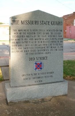
On East Main Street at Town Square, on the right when traveling east on East Main Street.
(front panel)
80 names listed
(rear)
Lest we forget, these men died for their freedom and independence. "Deo Vindice."
78 names listed — — Map (db m107369) WM
On West Street at Spring Street (U.S. 33), on the right when traveling south on West Street.
General John Hunt Morgan, CSA. On this site once stood the Ohio Penitentiary, which was built in 1834 and operated through 1984. Incarcerated here in July 1863 was Confederate General John Hunt Morgan, a cavalry commander known as the . . . — — Map (db m12966) HM
On Sullivant Avenue at Chestershire Road, on the right when traveling west on Sullivant Avenue.
(Side A): Camp Chase was a Civil War camp established in May 1861, on land leased by the U.S. Government. Four miles west of Columbus, the main entrance was on the National Road. Boundaries of the camp were present-day Broad Street (north), . . . — — Map (db m12078) HM
On High Street (U.S. 23) south of New England Avenue, on the right when traveling south. Reported permanently removed.
Roswell S. Ripley was born in Worthington on March 14, 1823 and graduated from the United States Military Academy in 1843. Serving with the U.S. Artillery from 1846 to 1848 during the Mexican-American War, Ripley was promoted twice for . . . — — Map (db m2050) HM
On Main Street (U.S. 36) at Clayton Street, on the right when traveling west on Main Street.
A descendent of Knox County’s earliest pioneers, Confederate Brigadier General Daniel Harris Reynolds was born just three miles west of Centerburg in 1832. He attended Ohio Wesleyan University in Delaware, where he became a close friend of Otho . . . — — Map (db m59460) HM
On Main Street at 5th Street, on the right when traveling south on Main Street.
(Front): Confederate Brigadier General War Between the States, 1861-1865
Born: 1832, Homer Township, Reached maturity in Malta Township, Morgan County K.I.A. November 30, 1864 Battle of Franklin, Tennessee (Rear): Placed by:
The . . . — — Map (db m13516) HM
On Steinwehr Avenue (Business U.S. 15), on the right when traveling south.
When Abraham Lincoln prophetically spoke of a "house divided", he might well have referenced the sons of Easias Jesse and Margaret Sutherland Culp. Both boys, William E. "William", (b. 1831) and John W. "Wesley", (b. 1839), grew up in Gettysburg and . . . — — Map (db m66431) HM
On West Confederate Avenue, on the right when traveling south.
(Front Inscription):That men of honor might forever know the responsibilities of freedom dedicated South Carolinians stood and were counted for their heritage and convictions abiding faith in the sacredness of states rights provided their . . . — — Map (db m12355) WM
On South Boundary Avenue SE at Newberry Street, on the right when traveling east on South Boundary Avenue SE.
The freshwater spring 1/2 mi. SE was used by prehistoric Indians. It was deeded to the town of
Aiken in 1844 by William Perroneau Finley (1803-1876) and furnished Aiken´s drinking water
throughout the 19th century. A regular stop on the . . . — — Map (db m63615) HM
On Wagener Road (State Highway 302 / 4) near New Holland Road, on the right when traveling west.
This is the site of Camp Butler, a
Confederate "camp of instruction"
that operated from the spring to
the fall of 1861, in what was then
Barnwell District. New companies,
organized as independent companies,
or in state regiments, were . . . — — Map (db m63281) HM
On Georgia Avenue (U.S. 25) near West Main Street, on the right when traveling south.
Korea
1950 — 1953
Dedicated to the men
and woman who bravely
fought in "The Forgotten
War". The first war to
end the spread of
communist tyranny
throughout the world. — — Map (db m31364) WM
On Georgia Avenue (Business U.S. 25) near West Clifton Avenue, on the right when traveling south.
Mexican War
1846 — 1848
Dedicated to the brave men of
South Carolina who along with
other Patriots willingly
served that the Nation might
expand its western horizons.
Of these men who willingly
volunteered to fight a . . . — — Map (db m30980) WM
On Georgia Avenue near West Clifton Avenue, on the right when traveling south.
Our fight for Independence
that assured us Freedom of
Speech, Religion, the Press,
Right to Peaceful Assembly
and right to Petition for
Redress of Grievances. We
enjoy our present freedom
because of the willingness
of our . . . — — Map (db m30819) HM
On Georgia Avenue near West Clifton Avenue, on the right when traveling south.
Spanish American War
1898
The battle with the
slogan "Remember the
Maine", brought the
United States as a
great power and the
beginning of overseas
recognition. — — Map (db m31208) WM
On Georgia Avenue near West Clifton Avenue, on the right when traveling south.
War Between The States
1861 — 1865
Let the stranger who may in
future times read this
inscription recognize that
these were men whom power
could not corrupt, whom death
could not terrify, whom
defeat could not dishonor, . . . — — Map (db m31127) WM
On Georgia Avenue (U.S. 25) near West Main Street, on the right when traveling south.
World War I
1914 — 1918
Dedicated to the men
and women who served
in the great war which
was believed to be the
final war of human
liberty and the "war to
end all wars". — — Map (db m31243) WM
On Georgia Avenue (U.S. 25) near West Main Street, on the right when traveling south.
World War II
1941 — 1945
Dedicated to the men and women
who battled globally to
secure a free world for
all mankind. The massive
production war effort caused
many women to enter industry
and changed the American . . . — — Map (db m31269) WM
On Buford's Bridge Highway (U.S. 321), on the left when traveling north.
(Barker's Mill side of marker):
Barker's Mill, which stood here on
Jackson Branch, was a grist mill
owned by William Ransome Barker
(1816-1869), a planter in what was
then Barnwell District. Barker moved
to this are in the . . . — — Map (db m7176) HM
On South Fant Street (State Highway 22) at East River Street (U.S. 76), on the right when traveling north on South Fant Street.
The location of the Anderson County Courthouse Annex on the corner of Fant and River Street has unique significance to Anderson's history. The site is the location of the 1865 federal encampment of the First Maine, 33rd Regiment, United States . . . — — Map (db m19838) HM
Sandy Springs Camp Ground: This Methodist camp ground named for the large spring nearby, dates to 1828, when a fifteen-acre site was purchased from Sampson Pope for $45. Early meetings were under a brush arbor until a central wooden shelter . . . — — Map (db m10785) HM
On Confederate Highway (State Highway 641) near State Park Road (County Route 5-8), on the right when traveling west.
Battle At Rivers Bridge
On February 2 ~ 3, 1865, as Gen. W.T. Sherman's
Federals advanced toward Columbia, units of
Gen. F.P. Blair's XVII Corps attempted to cross
the Salkehatchie River at Rivers Bridge. The
Confederate defenders . . . — — Map (db m7708) HM
On Burton Ferry Road (U.S. 301) at Carolina Highway (U.S. 321), on the right when traveling north on Burton Ferry Road.
(Front Text) Buford's Bridge, the earliest settlement in what is now Bamberg County, was established as early as 1792, when William Buford maintained a bridge and operated a ferry over the Salkehatchie River. It grew throughout the nineteenth . . . — — Map (db m7644) HM
On Craven Street at Church Street, on the right when traveling west on Craven Street.
Maxcy - Rhett House
This house was built circa 1810 for Milton Maxcy (1782-1817), who came here from Massachusetts in 1804. Maxcy and his brother Virgil, who founded a school for young men in Beaufort, later taught at Beaufort College. In the . . . — — Map (db m218490) HM
On Old State Road (U.S. 176) north of Shrike Road, on the right when traveling north.
Burial place of Lt. Col. Olin M. Dantzler, C.S.A. Appointed Brigadier General 1 June 1864 Defender of Charleston, SC and Petersburg, VA His recorded notes to General P.G.T. Beauregard led to the location of the submarine H.L. Hunley in 1995 Killed . . . — — Map (db m134424) HM
[South side]:
At every board a vacant chair fills with quick tears some tender eye, and at our maddest sport appear those well loved forms that will not die; we lift the glass, our hand is stayed - we jest , a spectre rises up - and . . . — — Map (db m27484) HM
On River Road at Plow Ground Road (South Carolina Highway 10-1156), on the right when traveling south on River Road.
(Front text) Federal Expedition on John's Island The Battle of Burden’s Causeway was the climax of a Federal expedition against John’s Island, July 2-9, 1864. 5000 Federals under Brig. Gen. John P. Hatch crossed the Stono River and . . . — — Map (db m29585) HM
On North Limestone Street (State Highway 150) at East Frederick Street (State Highway 18), on the right when traveling north on North Limestone Street.
Married June 27th, 1874.
Came to Gaffney in August, 1876.
Merchant, Banker, President of Mills,
Business Leader, Builder of Homes and
Houses of Business, Philanthropist.
This building was erected by A.N. Wood
in 1881, being from the . . . — — Map (db m7330) HM
(Front face):To the Confederate soldiers of Colleton County, SC
To those who fought and lived
To those who fought and died
To those who gave much
And to those who gave all
(Rear face):
To the mothers, wives, sisters and . . . — — Map (db m7064) HM
On Wire Road (State Highway 18-19) near Cowtail Road (State Highway 18-71), on the right when traveling west.
(Front text) This church was organized shortly after the Revolution and this site was deeded to seven trustees in 1787. One of them, Jacob Barr, was the first minister to serve here. Appleby’s Methodist Church was named for a prominent local . . . — — Map (db m26275) HM
On U.S. 15 near Old Spell Road, on the left when traveling north.
(Front text)
This church was founded in the early 19th century as Murray's Church and served by ministers riding the Cypress Circuit.
It was originally named for the Murray family, which also gave this town its first name of Murray's . . . — — Map (db m22006) HM
On Wire Rd. (State Road 18-19) near Sandy Branch Road, on the left when traveling west.
(Front text) This house, an excellent example of early Federal era-architecture, was built about 1800 for Joseph Koger, Jr. (1779-1866), planter, state representative 1806-1812, Colleton District sheriff 1813-18, and state senator 1818-1838. . . . — — Map (db m26349) HM
Born 1 mi. E. Cmdr. 1st Corps, Army of Northern VA Confederate States Army; Lee's "Old Warhorse"; West Point graduate; Mexican War veteran. — — Map (db m81747) HM
(Front text) This house, built between 1878 and 1885, was the home of James Washington Moore (1837-1912), lawyer, Confederate officer, state legislator, and militia officer. Moore, a native of Gillisonville, was educated at the University of . . . — — Map (db m26653) HM
On Fairview Road (U.S. 178) at Bagpipe Road, on the right when traveling south on Fairview Road.
Pinarea
Pinarea, the plantation owned by soldier, statesman, and manufacturer Paul Quattlebaum (1812-1890), was a mile E. Quattlebaum was a captain in the Seminole War and a brig. gen, in the S.C. militia by 1843. He was a state representative . . . — — Map (db m21869) HM
On New State Road at Old State Road (South Carolina Highway 32-66), in the median on New State Road.
(Front text) On February 15, 1865, as Gen. W.T. Sherman's Federal army advanced to Columbia, Gen. O.O. Howard's Army of the Tennessee found its way blocked by Confederates entrenched behind Congaree Creek and defending the Old State Rd. . . . — — Map (db m39818) HM
On Lewie Street (State Highway 32-737) at Waters Ferry Road (State Highway 32-37), on the right when traveling east on Lewie Street.
(Front) Lewie Chapel, a Methodist church founded on this site in the 1870s by Solomon R. Lewie (1835-1878) and others, was later known as Lewiedale Methodist Church and after 1910 as Gilbert Methodist Church. The original sanctuary, replaced . . . — — Map (db m30372) HM
On Nance Street, on the left when traveling south.
Front
Colonel Charles Trowbridge of the 33rd U.S. Colored Troops ordered the execution of Calvin Crozier, former private 3rd Kentucky Cavalry, on Sept. 8, 1865. Crozier, while en route to his Texas home, cut a troop member on the back of . . . — — Map (db m13305) HM
On Westminster Drive at Stratford Road, in the median on Westminster Drive.
Known as "Diamond Hill," which was burned by Union Troops during their invasion of Columbia, February 17, 1865, was located 125 feet due south of this spot.
The stones in this monument formed part of the foundation of that home. — — Map (db m46448) HM
On Main Street, on the right when traveling south.
[Front]:
The Jefferson Hotel, designed and built by Columbia entrepreneur and contractor John Jefferson Cain (1869-1929), stood here at the corner of Main and Laurel Streets from 1913 until 1968. The hotel (also sometimes called the . . . — — Map (db m21895) HM
This Confederate camp of instruction was once located about 1 mi. NW at Lightwood Knot Springs, site of a popular resort prior to the War Between the States. — — Map (db m30192) HM
On Farrow Road (State Highway 555) near Killian Road, on the right when traveling south. Reported missing.
On February 18, 1865, the day after Federals under Gen. W.T. Sherman occupied Columbia, Gen. Frank Blair ordered units of his XVII Corps to destroy railroad tracks north of the city. Portions of Gen. M.C. Butler’s Confederate cavalry division, . . . — — Map (db m228374) HM
Near Confederate Cemetery Road, 0.1 miles south of Old U.S. 41.
(Front):General A.P. Stewart Stewart's Division 2nd Army Corps (Hardee) Army of Tennessee CSA Dedicated 24th Day of April 2010 By Benjamin F. Cheatham Camp 72 Sons of Confederate Veterans Manchester, Tennessee (Reverse):Battle of . . . — — Map (db m30698) HM
In Honor of the men of the Confederate 1st/3rd Kentucky
Calvalry (Consolidated) who first encountered the
onslaught of Wilder's Brigade, Thomas's Corps of the
Union Army, North of Hoover's Gap June 24, 1863 — — Map (db m166932) WM
On East Main Street at Mayland Road, on the right when traveling east on East Main Street.
Less than half a mile west of here, on the Lewis Whitaker farm, the only engagement of the war in Cumberland County between regular Union and Confederate troops took place on December 9, 1863. Several companies of Col. Thomas J. Jordan’s 9th . . . — — Map (db m69228) HM
Adelicia Hayes was the daughter of Oliver Bliss Hayes. At times Hayes was a lawyer, judge, Presbyterian minister and a land speculator. Adelicia married 50-year-old Isaac Franklin when she was 22. Franklin's home, Fairvue, still stands outside of . . . — — Map (db m166484) HM
Though Heiman was first buried in Mississippi, admirers brought Heiman's remains to Confederate Circle where they now rest beneath the monument. Confederate officers had recommended he be promoted to brigadier general, and this was confirmed four . . . — — Map (db m166483) HM
Caroline Meriwether was the first child of Charles and Caroline Meriwether. Their estate, “Woodstock”, overlapped the Tennessee-Kentucky border near Clarksville. Her father's chief occupation was raising thoroughbred horses, which led . . . — — Map (db m166494) HM
Maney's grave is located about 75 feet up the hill under a cedar tree.
The Maneys were French Huguenots. They lived in the seaport town of Meschers where they witnessed the migration of Huguenots escaping Catholic persecution. The Maneys first . . . — — Map (db m166475) HM
Hylan Rosser is but one of 1,492 Confederate soldiers buried here in Confederate Circle. Most of the dead do not have marked graves, and there are no known photographs of most. Rosser has been chosen as a representative of those soldiers who gave . . . — — Map (db m166488) HM
Rains is buried about 30 feet back, with a flat granite marker. Rains graduated from Yale Law School in 1854 and began a practice in Nashville. In 1858 he married Ida Yeatman, and they had one child, Laura. Rains also served as city attorney and as . . . — — Map (db m166490) HM
Though largely forgotten today, John Bell was one of the last great American statesmen. He was born in Davidson County in 1796, the year Tennessee became a state. Bell was elected to the U.S. Congress defeating Felix Grundy, Bell's service, . . . — — Map (db m166482) HM
Born in Washington County, Tennessee, Henry Melville Doak was an adventurous young man who tried twice, at age 4 and at 7, to run away from home and join the militia headed off to fight in the Mexican War. Several years older, he gave up the study . . . — — Map (db m166491) HM
Mary Bradford Johns and husband John Johns are buried about 75 feet ahead.
Mary Bradford was descended from several Virginia patriots of the Revolutionary War. Her grandfather, Captain John Bradford, came to Tennessee soon after the war, . . . — — Map (db m166489) HM
Mary Kate was the daughter of Dr. Hugh and Ellen T. Patterson. They lived along Nolensville Pike in the defunct community of Rashboro, now within Nashville. She was attending Elliott School when the U.S. capture of Nashville interrupted her . . . — — Map (db m166486) HM
Rachel Carter's diary is the source of her varied experiences in Nashville during the war. Her father, Daniel Carter, was a bank president. The Carter home was at the corner of High Street (now 6th Avenue) and Union. Rachel and her husband, Thomas . . . — — Map (db m166478) HM
Smith has a flat granite marker here in Confederate Circle. About 1,500 Confederate soldiers lie within the circle. Many were prisoners that died from wounds or illness. Others died in area battles. Smith lived until 1923 and was one of the last . . . — — Map (db m166487) HM
Bate's grave is easy to locate as his monument has a raised relief of his profile. He was born at Castalian Springs in Sumner County. In 2004 the Bate home is still occupied as a private residence and noted by a historical marker on Highway 25. . . . — — Map (db m166480) HM
Jackson's parents migrated from Virginia. He was born in Paris, Tennessee, but his parents moved to Jackson when he was five. He graduated from West Point in 1856 and served in the U.S, Army. His service was primarily in what is now New Mexico, . . . — — Map (db m166493) HM
Beall's grave is about 70 feet up the slope.
Beall was born in Bardstown, Kentucky, but his family moved to Arkansas. He graduated from West Point in 1848, and largely served on the western frontier. He resigned from the U.S. Army as Arkansas . . . — — Map (db m166476) HM
On West Main Street west of High Street (Tennessee Route 53), on the left when traveling west.
Side 1-Gen. John H. Morgan CSA
Side 2-Gen. Morgan left here Dec. 21, 1862, with 2,500 horsemen on his Kentucky Christmas Raid. The raid concluded in Smithville Jan. 5, 1863, after the raiders captured 1887 enemy soldiers and destroyed $2,000,000 in . . . — — Map (db m74323) WM
On South Public Square at South 3rd Street, on the left when traveling east on South Public Square.
(south face)
Atlanta • Chickamauga • Murfreesboro
This monument is dedicated to the memory of all DeKalb Countians who served the Confederacy. They sacrificed much for the cause of an independent South. Their courage and patriotism . . . — — Map (db m75792) WM