163 entries match your criteria. The first 100 are listed. The final 63 ⊳
Time Capsules Historical Markers
Time capsules preserve the salient features of history and can serve as valuable reminders of one generation for another. They can be found the world over and have been placed in the cornerstones of buildings, within parks, inside of monuments, at historic sites, and so forth. Usually, but not always, there is a commemorative plaque or sign of some sort to indicate the occasion of the placement, the date it was placed, the date to be opened, and the sponsoring organization.
By David J Gaines, February 28, 2011
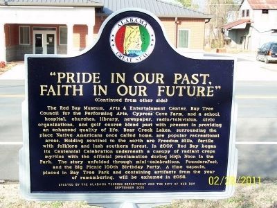
Pride in Our Past, Faith in Our Future Marker - Side B
On 4th Avenue SE, on the left when traveling west.
Side A Red Bay is nestled in the northwest corner of the state in Franklin County. The oak trees, planted by the Garden Club in 1937, issue a Main Street welcome through the “tunnel of trees.” Originally inhabited by Chickasaw . . . — — Map (db m41133) HM
On Broadway Avenue (County Road 55) at Midland Street, on the right when traveling north on Broadway Avenue.
Ashford was incorporated on June 22, 1891. Citizens, friends, and families of Ashford gathered here on June 22, 1991, to remember Ashford's durable and progressive history. This commemoration also affirmed their faith in Ashford's future by placing . . . — — Map (db m73411) HM
Near 3rd Avenue North near Richard Arrington Jr, Blvd North.
To Be Opened March 1, 2022
Dedicated at the construction completion March 1, 2002
Project Team
Owners - BLH Group, LLC
Brookmont Investors II, LLC
Spire Holdings, LLC
Developer - Brookmont Realty Group, LLC
General . . . — — Map (db m27010) HM
On Monroe Street Northwest at Washington Street Northwest, on the left when traveling east on Monroe Street Northwest.
Interred on November 17, 2012 to commemorate Madison County's military history and to preserve items reminiscent of our Veterans' proud service to this great nation.
To be opened November 11, 2062 — — Map (db m85613) WM
In memory of the gallant men who gave their lives on December 7, 1941 on the Battleship U.S.S.
Arizona during the attack on Pearl Harbor
Dedicated December 7, 1976
The Honorable Raul H. Castro, Governor of Arizona
The contributions . . . — — Map (db m26425) HM
Near Grandview Avenue near West Beale Street (Business Interstate 40).
Dedicated in Memory of
Charles Metcalfe
1855-1943
He deeded in perpetuity this land as a park for the use of Kingman youth. Recognized as a civic leader and land developer, He proposed development of Hualapai Mountain Park. He held . . . — — Map (db m29362) HM
The Little Rock was not always as it is now. To support
the Junction Bridge and ensure an adequate channel for
river traffic, much of the Rock was removed in 1872 and
1884. No one knows how the Point of Rocks looked
before progress took its . . . — — Map (db m116557) HM
On Foothill Boulevard (U.S. 238) at City Center Drive, on the right when traveling north on Foothill Boulevard.
Lt. Colonel Juan Bautista de Anza by decree of Carlos III of Spain led an expedition to this site – The mission being to colonize the San Francisco Bay Area
In the center of the marker is a circular motif, designed by Doris Birkland . . . — — Map (db m28815) HM
The Laboratory opened September 2, 1952 at this site, initially as a branch of the University of California Radiation Laboratory. Prior to the Lab's opening, this 630-acre parcel was the site of Livermore Naval Air Station, a World War II pilot . . . — — Map (db m25251) HM
On Portola Avenue, on the right when traveling east.
Born in England 1799 – Died Rancho Las Positas 1858. Arrived in Monterey 1822. Married Josefa Higuera y Puentes 1830. Settled on Rancho Las Positas 1835.
“Next to the Mission Fathers, he was the first man to engage himself in the culture of . . . — — Map (db m199846) HM
On Main Street, on the right when traveling north.
(There are five markers and one dedication plaque affixed to the flagpole pedestal.)
History of Copperopolis
Copper (for ore) + opolos (for city)
Originally known as Copper Canyon, Copperopolis was established in 1860 when copper . . . — — Map (db m62356) HM
On Fresno Street near L Street, on the right when traveling east.
La Ville d'Etamps
a l'Amerique
This monument from General Patton's Route of Liberation is a gift of the people [of] Cannes, France to the people of California, sent via La Train de la Reconnaisance Francaise (Merci Train) and dedicated . . . — — Map (db m131236) HM
Near North Alameda Street at Los Angeles Street, on the right when traveling south.
On May 5, 1979, the President of the United States, Jimmy Carter, participated in the dedication of this Placita de Dolores. The following is a memorable excerpt from his remarks:
“... Freedom is never permanently ours, despite the . . . — — Map (db m162117) HM
On Vine Street at Sunset Boulevard, on the right when traveling north on Vine Street.
On February 13, 2004, the Entertainment Industry's Time Capsule, buried on this world-famous corner since 1954, was opened to commemorate another 50 years of Hollywood
history. It was on this block that Cecil B. DeMille directed Hollywood's . . . — — Map (db m231871) HM
On Hollywood Boulevard at Highland Avenue, on the right when traveling west on Hollywood Boulevard.
At this location on August 15, 1958 the first eight stars on the Hollywood Walk of Fame were dedicated to Olive Borden, Ronald Colman, Louise Fazenda, Preston Foster, Burt Lancaster, Edward Sedgwick, Ernest Torrence and Joanne Woodward.
The Walk . . . — — Map (db m204738) HM
Near Figueroa Street south of Exposition Boulevard, on the right when traveling south.
Bud Greenspan's
"16 Days of Glory,"
the official film
of the games of the XXIIIrd Olympiad.
Buried on June 18, 1987
by Mayor Tom Bradley and the Disney Channel.
Time capsule to be opened on July 28, 2034.
second marker: . . . — — Map (db m239675) HM
Near Ocean Front Walk south of 18th Avenue, on the right when traveling south.
Committed December 13, 2009.
To be opened 2059.
Sponsored by: Iron Man Magazine .com
in conjunction with
Councilmember Bill Rosendahl, 11th District;
City of Los Angeles Recreation and Parks. Created and developed by
Joseph and Christine . . . — — Map (db m231062) HM
On South Main Street, on the right when traveling south.
Built in honor of World War 1 Veterans
on the site of W.H. Russell’s Livery Stable
by Colfax Post 192 American Legion
23 Apr. 1927
Cornerstone laid & building dedicated
for community use
26 June 1928
Agreement: Joint ownership . . . — — Map (db m45232) HM
On Carlsbad Boulevard at Grand Avenue on Carlsbad Boulevard.
In 1881, Captain John A. Frazier, a homesteader, purchased 127 acres of oceanfront land for $1200. While drilling for drinking water in 1884, Frazier tapped into an underground mineral spring. He built a 510 foot well tower and began promoting the . . . — — Map (db m100673) HM
On 1100 Orange Avenue (California Route 75) at Park Place on 1100 Orange Avenue.
Naval Aviation Centennial 1911-2011
Coronado, the Birthplace of Naval Aviation
Time capsule commemorating the
Centennial of Naval Aviation is buried here — — Map (db m117061) HM
On Marshall Street, on the right when traveling west.
On the evening of September 11, 1861, a group of concerned citizens met at the San Mateo County Courthouse. Their mission was to organize the Redwood Hose Company for the purpose of providing fire protection to the small settlement of Mezesville and . . . — — Map (db m202493) HM
Sequoia Union High School was founded in Redwood City in 1895, having two downtown locations before moving to the present site in 1924. With the exception of the Class of 1917, the tradition of installing graduation year plaques began with the first . . . — — Map (db m55258) HM
On El Camino Real (State Highway 82), on the right when traveling north.
Lt. Colonel Juan Bautista de Anza by decree of Carlos III of Spain led and expedition near this site – The mission being to colonize the San Francisco Bay Area.
In the center of the marker is a circular motif, designed by Doris Birkland . . . — — Map (db m24727) HM
On Plaza Circle at North Del Puerto Avenue, on the left on Plaza Circle.
For generous contributions of time, land and facilities to the City of Patterson, citizens of Patterson recognizes these direct contributions as monuments to Jack Patterson’s heritage to the City of Patterson.
Contributions
1.Historical Building . . . — — Map (db m208523) HM
On Plaza Circle at West Las Palmas Avenue on Plaza Circle.
This bell was for many years at the honor farm at Frank Raines Park in the Del Puerto Canyon and was returned to Patterson because it was believed to be either the old Las Palmas School bell or the Presbyterian Church bell, both structures which are . . . — — Map (db m27357) HM
Near East 160th Avenue (East Bridge Street) (State Highway 7) just east of South 4th Avenue (State Highway 2), on the right when traveling east.
Historic City Hall was initially built as the first permanent Adams County Courthouse. The courthouse was designed in 1904 by architect John James Huddart, who also designed the Brighton Armory. In 1906, builder A.B. McDonald completed the . . . — — Map (db m203311) HM
Memorial Stone commemorating the 100th Anniversary of the laying of the cornerstone of the Colorado State Capitol. The time capsule beneath this stone contains messages and memorabilia from the people of Colorado in 1990 to its people in 2090. . . . — — Map (db m46059) HM
On Mathews Street, on the right when traveling north.
The building that today houses the Fort Collins Museum was constructed in 1903, as a public library. Steel
magnate Andrew Carnegie provided $12,000 in funds for the construction. Opened to the public on August 24,
1904, the Carnegie Library . . . — — Map (db m51350) HM
Near Noble Avenue north of Crown Street, on the left when traveling north.
Our Big Cow was originally displayed at the Danbury Fair, one of the largest agriculture fairs in the country for many years.
Thank you to our Big Cow sponsor, Wade's Dairy.
The Big Cow has also become a Time Capsule to be opened in . . . — — Map (db m230931) HM
On Rye Street at Old Ellington Drive, on the left when traveling south on Rye Street.
Spirit of Unity
Time Capsule
To be Opened June 10, 2092
Dedicated June 10, 1992
To the People
of
East Windsor, South Windsor and Ellington
Who united in purpose on June 10, 1991 to oppose
the siting of a radioactive dump in order to . . . — — Map (db m113960) HM
Buried 8-18-1984 by
Union Historical Society
Uncover 8-19-2034
This was the stepping stone
to The Center School C. 1844
Plaque gift of Gertrude and Maurice Chappell — — Map (db m123874) HM
On Stone Bridge Road at Route 169 on Stone Bridge Road.
Front The industry of northeastern
Connecticut had its earliest
beginnings in this area, Soon
after arriving in 1686 the early
settlers built a sawmill on a
small brook running into the
“Great Lake.” Later several . . . — — Map (db m123797) HM
On Lincoln Circle Northeast north of Tapscott Street Northeast, on the right when traveling south.
Panel 1
“Ole Jim” Fondly known by Gallaudet alumni as “Ole Jim,” this building was the first Gallaudet College gymnasium. Designed by Frederick Withers and built in 1881, it was the nation’s second gymnasium . . . — — Map (db m40440) HM
On 19th Street Northwest north of G Street Northwest, on the right when traveling south.
The International Monetary Fund (IMF) promotes cooperation among its member countries on monetary and economic matters. The IMF was established at a conference held at Bretton Woods, New Hampshire, on July 1-22, 1944. Nearly all countries of the . . . — — Map (db m111527) HM
Near Pennsylvania Avenue Northwest west of 7th Street Northwest, on the right when traveling west.
The rank of chief petty officer - the senior position among naval enlisted ranks - was established by the Navy Department in 1893. A time capsule was placed within this foundation on 13 October 1993 to be opened in the chiefs’ bicentennial year . . . — — Map (db m109755) HM
On State Road A1A, on the right when traveling south.
The men and women of the Air Force Eastern Test Range proudly dedicate this monument to our national progress in missile and space technology in recognition of the American revolution Bicentennial. Erected on site of support elements for early space . . . — — Map (db m57602) HM
On South Church Avenue (State Road 37) at SE 1st Street, on the right when traveling north on South Church Avenue.
This marker commemorates the dedication of the Mulberry Time Capsule. The capsule was placed here on June 12, 1977 by the Greater Mulberry Chamber of Commerce. The capsule will be opened in the year 2076 to view the mementoes of the 1976 . . . — — Map (db m4984) HM
On Peachtree Road (Georgia Route 141) at Lanier Drive, on the right when traveling south on Peachtree Road.
Chartered in 1835 by Georgia Presbyterians near Milledgeville, Oglethorpe University was the first denominational college established in the Deep South.
It perished during the Civil War and was briefly revived from 1870 to 1872 in Atlanta. . . . — — Map (db m14291) HM
On Guidestone Road Northwest, 0.1 miles east of Hartwell Highway (Georgia Highway 77), on the right when traveling east.
The story of the Georgia Guidestones began in June 1979, when a stranger identified as "Mr. Christian" (later "R.C. Christian") visited Jo H. Fendley, Sr., President of Elberton Granite Finishing Company, Inc., and indicated that he represented a . . . — — Map (db m57909) HM
Near Luckie Street east of South Perry Street (Georgia Route 20), on the right when traveling east.
[Time capsule]
In honor of the
Gwinnett Bicentennial
December 15, 2018
To be opened December 15, 2118
[Sign, left panel]
Gwinnett County: A vibrantly connected community
Gwinnett County anchors the . . . — — Map (db m197716) HM
Near Main Street (Old Cleveland Road) (Georgia Route 254) just north of Concord Church Road, on the right when traveling north.
For more than a century, this site has served many pursuing an education. The earliest known school, Concord Academy, initially began serving this community as an extension of Concord Baptist Church. In 1901, the Chattahoochee School was established . . . — — Map (db m174077) HM
On West Jefferson Street at North 6th Street, on the right when traveling west on West Jefferson Street.
Placed here by Ezra Meeker on May 9, 1906
Pioneer • Preservationist • Visionary
Ezra Meeker was largely responsible for locating and preserving the Old Oregon Trail. To commemorate the centennial of this monument, a time capsule of . . . — — Map (db m128544) HM
On North Main Street (Illinois Route 143) 0.1 miles north of Hillsboro Avenue, on the right when traveling north.
First erected in 1923 at the corner of St. Louis Street and North Main Street
Through funds raised by public donations, the clock was relocated in this Clock Tower park and presented to the City of Edwardsville in gratitude for its . . . — — Map (db m52630) HM
On Old Route 66 North just south of West Kirkham Street, on the left when traveling south.
The cornerstone of the American Radiator plant was laid on June 9, 1904. The plant occupied 28 acres on the southeast edge of town and produced cast iron radiators. During World War II, it converted to the manufacture of sand-molded magnesium . . . — — Map (db m147469) HM
Near Fort Armstrong Road at Rodman Avenue, on the right when traveling south.
Upon this site on the fourteenth day of May in the year of our Lord one-thousand nine-hundred and sixty-six, members of the Rock Island Arsenal, tenant agencies and members of the surrounding communities did commemorate the one-hundred fiftieth . . . — — Map (db m230209) HM
Near West Jefferson Street (U.S. 30) east of U.S. 6, on the right when traveling east.
Behind this plaque is a 16 x 12 x 13 inch copper box which was filled by the Will County Committee of the Illinois Sesquicentennial Celebration (1968). This is to be opened in one hundred years.
Beside the plaque is the cornerstone of Will . . . — — Map (db m158522) HM
Near South Clinton Street (U.S. 27) 0.3 miles south of East 4th Street, on the right when traveling south. Reported damaged.
Headwaters Park has been created by the citizens of Fort Wayne through their donations, ideas, and labor as a means of flood control in the city. Earlier designs had a similar purpose. George Kessler's plan of 1912 envisioned a greenspace for . . . — — Map (db m197058) HM
On East Main Street near South Barr Street, on the right when traveling west.
A capsule was buried on this site on May 11, 2002 when citizens of Takaoka and Fort Wayne met to re-affirm an alliance established in 1977. The capsule, containing articles related to the 25th anniversary, will be opened on the occasion of the . . . — — Map (db m239279) HM
On West Main Street at South Washington Street, on the left when traveling west on West Main Street.
( Smaller Stone Marker )
In Memory of
All Deceased Veterans
OF ALL WARS
Buried in Hendricks County
( Bronze Marker )
Hendricks County
War Memorial
This memorial is dedicated to the Hendricks County . . . — — Map (db m19451) WM
On South Main Street (U.S. 50) at East Cross Street, on the right when traveling north on South Main Street.
In Memory of Col. John Ketcham
1782 - 1865
Fearless pioneer, Ranger, surveyor, public servant who dedicated this public square for seat of government of Jackson County, Ind. when Brownstown was founded April 8, 1816.
Time Capsule . . . — — Map (db m46756) HM
On North Meridian Street at East St. Clair Street, on the right when traveling north on North Meridian Street.
American Legion Mall comprises two city blocks and is the largest of the five-city block plaza. The actual mall is located at the north end of this part of the plaza. The plaza's overall design is reflective of The National Mall in Washington, . . . — — Map (db m132852) HM
On North Meridian Street at East North Street, on the right when traveling north on North Meridian Street.
American Legion Mall comprises two city blocks and is the largest of the five-city block plaza. The actual mall is located at the north end of this part of the plaza. The plaza's overall design is reflective of The National Mall in Washington, . . . — — Map (db m132837) HM
On North Pennsylvania Street at East St. Clair Street, on the right when traveling south on North Pennsylvania Street.
American Legion Mall comprises two city blocks and is the largest of the five-city block plaza. The actual mall is located at the north end of this part of the plaza. The plaza's overall design is reflective of The National Mall in Washington, D.C. . . . — — Map (db m132857) HM
On North Pennsylvania Street at East North Street, on the right when traveling south on North Pennsylvania Street.
American Legion Mall comprises two city blocks and is the largest of the five-city block plaza. The actual mall is located at the north end of this part of the plaza. The plaza's overall design is reflective of The National Mall in Washington, . . . — — Map (db m132861) HM
On North 3rd Street just north of East Graham Street, on the right when traveling north.
Located 5 feet north To be opened July 4, 2076 Dedicated November 15, 1976 Newton County Bicentennial Committee County Board of Commissioners “Pun’kin Vine” Fair Board — — Map (db m237798) HM
On Main Street at North Orange Street, on the right when traveling west on Main Street.
Albion - Noble County Seat
The Center - later named Albion was chosen the Seat of Noble County Indiana by the vote of its citizens in August 1846.
Since that time three courthouses have been located on this square.
The first which . . . — — Map (db m53950) HM
On North 2nd Street south of East Main Street, on the left when traveling south.
On this 27th day of February, 1992 the citizens of Warrick Co. Dedicate this monument to the Men and Women from our county who served in the United States Armed Forces in Operation Desert Shield / Storm and all military personel involved . . . — — Map (db m243603) WM
On Estates Way at Homestead Drive, in the median on Estates Way.
Dedicated to the original homestead families and their descendants. Brought to fruition through the efforts of the U.S. Government, the Franklin Roosevelt, MGSR. Luigi Ligutti and the Grace of God. In commemoration of the 50th anniversary of the . . . — — Map (db m83950) HM
A collection of materials and important papers representative of the period were buried in a time capsule in front of this marker during the 1972 Osceola County Centennial Celebration.
Those involved in this, did so with the hope that it . . . — — Map (db m119050) HM
On Main Street at 1st Street, on the left when traveling south on Main Street.
Be it hereby known that on June 23, 1977 a time capsule was herein placed to commemorate 100 years of progress for Odebolt, Iowa. It is our wish that this time capsule be reopened in the year of 2077. Odebolt, Iowa The star in the crown of Iowa . . . — — Map (db m162249) HM
On West Washington Street just west of South Iowa Avenue, on the right when traveling west.
In grateful appreciation for the heritage of our forefathers, this monument and its contents are dedicated to those generations yet to come. Time capsule to be opened July 4, 2076 — — Map (db m238399) HM
On Fowler Avenue (U.S. 160) at Main Street, on the left when traveling east on Fowler Avenue.
[Barber County Veteran Tiles]
Twin Towers Beam
This steel beam is from the Twin Towers that were destroyed by foreign terrorists on 9-11-01. New York City has donated it to the Barber County Veterans Memorial in remembrance of the lives . . . — — Map (db m65211) WM
In commemoration of Hays Centennial - 1967
Plastic capsule buried May, 1967 - to be exhumed 2067
Buried 10' 0" below this marker.
The Time Capsule is to provide historical reference on the progress of Kansas family farmers working with the . . . — — Map (db m59719) HM
On Kansas Avenue north of Park Avenue, on the right when traveling north.
Beneath this stone is buried a capsule containing papers and items used in celebrating the American Revolution Bicentennial in Johnson County, Kansas. Placed on this Thanksgiving Eve November 24, 1976 A.D. by the Johnson County Bicentennial . . . — — Map (db m69376) HM
On 17th Street N at Fairmount Avenue, on the left when traveling east on 17th Street N.
From its beginning as Fairmount College in 1895, Wichita State University has stood, like these columns, “proudly on the hill” – a phrase from the university’s “Alma Mater” referencing the highest point of land in . . . — — Map (db m56257) HM
On South Main Street (U.S. 27), on the right when traveling south.
North United States 200th anniversary time capsule buried in 1976 contains histories of families, places and businesses of Harrison County to be opened in 50 years on July 4, 2026.
South Harrison County's 175th anniversary history capsule . . . — — Map (db m218104) HM
On East 10th Avenue at College Street, on the left when traveling north on East 10th Avenue.
Bicentennial time capsule placed in the lawn of the Warren County Courthouse on March 7, 1998.
To be opened March 7, 2098 by the governments of Bowling Green & Warren County.
(reverse) Warren County, the 24th county formed in Kentucky, . . . — — Map (db m139488) HM
On East Pine Street (State Highway 22) near Southeast Railroad Avenue, on the left when traveling west.
This memorial is dedicated to all the officers and men who served aboard the USS Ponchatoula (AO-148) from its commissioning in January 1956 until its retirement from naval service in August 1992. The Ponchatoula was a Neosha Class Fleet Oiler . . . — — Map (db m115387) HM WM
On Main Street (U.S. 1A/202) near Emerson Street, on the left when traveling north.
This statue, reputed to be the largest of Paul Bunyon in the world, stands facing the Penobscot River. The legendary giant woodsman is a symbol of the great era in the late 1800's when Bangor, Maine was acclaimed to be "The Lumber Capitol of the . . . — — Map (db m4938) HM
On Frederick Avenue (Maryland Route 144) at Font Hill Avenue, on the right when traveling west on Frederick Avenue.
The burial place of Methodist pioneers including Bishops Francis Asbury, Enoch George, John Emory and Beverly Waugh, also Robert Strawbridge, first preacher in Maryland and Jesse Lee, founder in New England. Site of 1966 Methodist Bicentennial time . . . — — Map (db m33697) HM
The heroic bronze figure in front of you is not, as many suppose, a likeness of Francis Scott Key. The statue represents Orpheus, the artful poet, musician, and singer of Greek Mythology.
In 1914 Congress appropriated funds for a . . . — — Map (db m707) HM
On West Pratt Street west of South Poppleton Street, on the left when traveling west.
This Stone presented by the Stone Cutters of Baltimore, in commemoration of the commencement of the Baltimore and Ohio rail road, was here placed on the Fourth of July, 1828, by the Grand Lodge of Maryland, assisted by Charles Carroll of Carrollton, . . . — — Map (db m243537) HM
Near Georgia Avenue, on the right when traveling north.
This geodetic mark was established to commemorate 200 years of science, service, stewardship to the nation by NOAA and its predecessor agencies and to mark the location of NOAA's 200th Celebration Time Capsule. The materials reflect the essence of . . . — — Map (db m66195) HM
On North Salisbury Blvd (U.S. 13) at Priscilla St, on the left when traveling south on North Salisbury Blvd.
Wicomico County War Memorial was designed by Mr. James K. Agnew a local citizen and constructed in 1955 with help and support of the local American Legion and Veterans of Foreign Wars posts at a time loses of some of our Nations most hard-fought . . . — — Map (db m142712) WM
Near Front Street at Commercial Street, on the left when traveling west.
In honor of the courageous men and women of Worcester who served our country in the spirit of securing freedom, democracy, and peace for our nation and the world. May the memory of their bravery endure through the annal of time.
Presented by . . . — — Map (db m151789) WM
On Center Street at Union Street, on the left when traveling east on Center Street.
Dutcher Lodge No. 193
Masons from Douglas, Fennville, and Saugatauk chartered Dutcher Lodge No. 193 on January 19, 1867. From 1867 to 1870 they held meetings in a building owned by Worshipful Master Thomas Dutcher. In 1875, the western . . . — — Map (db m45393) HM
Near W. Main Street, 0.1 miles west of Front Street, on the right when traveling west.
(South Face of Memorial)
You a veteran of this
Old town or pilgrim
From far away looking
For some tranquility...
Here you may become
Silent in honor of those
Who have served...
No one is a stranger at
This revered place . . . — — Map (db m68541) WM
On East State Street (State Highway 21) just west of North Clinton Avenue, on the left when traveling west.
Here on this 18th day of July, A. D. 1956, the people of St. Johns, Michigan, dedicate this tree and monument to the courage and sacrifice of our forebears, who founded this city 100 years ago. ————————————— Beneath this monument is buried a metal . . . — — Map (db m213099) HM
On Cass Street south of State Street, on the right when traveling south. Reported missing.
On July 28, 1869, eight Traverse City women organized the Ladies Library Association. In 1878 the association purchased its first building, at 205 East Front Street. In 1909 the association sold that building and retained Fred E. Moore as architect . . . — — Map (db m98228) HM
On State Road near West Huron Street, on the right when traveling east.
Port Hope became incorporated as a
village in 1887. During the centennial
celebration in 1987, it was decided to
create a time capsule to preserve
memorabilia. On July 2, 1989 a
container filled with a variety of items
was buried at this . . . — — Map (db m225984) HM
On 6th Street (County Route 20) at 2nd Avenue, on the right when traveling north on 6th Street.
[Text interspersed with photos]
Thomas Owens was affectionately known at "T.O.".
The White Houses located between 2nd and 3rd Avenues on Poplar Street were once owned by Railroad Superintendent George White. After his passing and by . . . — — Map (db m78857) HM
On Bush Avenue west of Forest Street North, on the right when traveling west.
Setting the Cornerstone, Building 21
President William L. McKnight, accompanied by chief engineer E. M. Johnson, supervised the installation of the cornerstone in October 1939.
The mason worked for the William Murphy and Son Construction . . . — — Map (db m151373) HM
On Jefferson Street at Capitol Avenue, on the left when traveling north on Jefferson Street.
Meriwether Lewis • William Clark
York • Seaman • George Drouillard
———————
Sculptor: Sabra Tull Meyer
Columbia, Missouri
Project Designer: Austin Tao
St. Louis, Missouri . . . — — Map (db m62317) HM
On Court Square (Washington Avenue) at West Main Street, on the left when traveling south on Court Square (Washington Avenue).
Beneath this marker is a Time Capsule buried December 17, 1976, at 2:00 P.M. by the West Plains Bicentennial 1976 Steering Committee to be disinterred July 4th, 2076 by the Howell County Court Time capsule donated by . . . — — Map (db m186135) HM
On Maiden Lane north of 26th Street/Gabby Street Boulevard, on the right when traveling north.
May 22, 2011 - The people of Joplin pull each other from the rubble. Memorial Hall becomes makeshift hospital, stage becomes the morgue. AmeriCorps sends its first volunteers to help. Thousands of volunteers begin to arrive.
May 23, 2011 - . . . — — Map (db m108845) HM
On 2nd Street near Court Street (U.S. 136), on the left when traveling north.
Dedicated to the Citizens of Beatrice
for all their efforts put forth in the
Beatrice Centennial Celebrations of 2007
Beatrice, Nebraska Territory
Founded on this site July 4, 1857
Time Capsule to be opened on July 4, 2057
200 . . . — — Map (db m47616) HM
163 entries matched your criteria. The first 100 are listed above. The final 63 ⊳