67 entries match your criteria.
National Underground Railroad Network to Freedom Historical Markers
The National Underground Railroad Network to Freedom commemorates the stories of the men and women who risked everything for freedom and those who helped them. The Network to Freedom, through shared leadership with local, state, and federal entities, as well as interested individuals and organizations, programs and partnerships to commemorate and educate the public about historical significance of the Underground Railroad.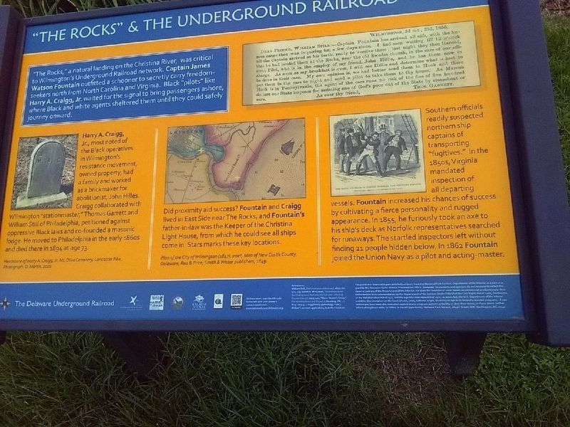
By Carl Gordon Moore Jr., July 6, 2023
"The Rocks" and the Underground Railroad Marker
| 1 ► Delaware, New Castle County, Wilmington — "The Rocks" and the Underground Railroad — The Delaware Underground Railroad — |
| On East 7th Street. | |||
| 2 ► District of Columbia, Washington, Northwest Washington, Adams Morgan — Rediscovery and Remembrance — Hallowed Ground — Rock Creek Park, National Park Service, U.S. Department of the Interior — |
| On Calvert Street Northwest at 20th Street Northwest, on the right when traveling west on Calvert Street Northwest. | |||
| 3 ► District of Columbia, Washington, Northwest Washington, Adams Morgan — Resilience and Resistance — Hallowed Ground — Rock Creek Park, National Park Service, U.S. Department of the Interior — |
| On Calvert Street Northwest at 20th Street Northwest, on the right when traveling west on Calvert Street Northwest. | |||
| 4 ► District of Columbia, Washington, Northwest Washington, Adams Morgan — Seeking Freedom — Hallowed Ground — Rock Creek Park, National Park Service, U.S. Department of the Interior — |
| On Calvert Street Northwest at 20th Street Northwest, on the right when traveling west on Calvert Street Northwest. | |||
| 5 ► District of Columbia, Washington, Northwest Washington, Adams Morgan — Soldiers, Sailors, and Refugees of War — Hallowed Ground — Rock Creek Park, National Park Service, U.S. Department of the Interior — |
| On Calvert Street Northwest at 20th Street Northwest, on the right when traveling west on Calvert Street Northwest. | |||
| 6 ► District of Columbia, Washington, Northwest Washington, Penn Quarter — e.2 — Ending Slavery in Washington — Civil War to Civil Rights — Downtown Heritage Trail — |
| On 6th Street Northwest at Indiana Avenue Northwest, on the right when traveling south on 6th Street Northwest. | |||
| 7 ► District of Columbia, Washington, Southeast Washington, Barney Circle — National Underground Railroad Network to Freedom — |
| Near E Street Southeast just east of Potomac Avenue Southeast, on the right when traveling east. | |||
| 8 ► Florida, Miami-Dade County, Key Biscayne — Escaping to Freedom in the Bahamas — |
| Near Cape Florida Park Boulevard at South Crandon Boulevard, on the left when traveling south. | |||
| 9 ► Indiana, Floyd County, New Albany — The Town Clock Church — |
| On East Main Street (State Road 111) at East 3rd Street, on the right when traveling east on East Main Street. | |||
| 10 ► Indiana, Jefferson County, Madison — 39.2006.2 — John H. and Sarah Tibbets — |
| On Boyd Road (County Road N700W) 0.3 miles north of State Road 250, on the right when traveling north. | |||
| 11 ► Iowa, Polk County, West Des Moines — Welcome to the Jordan House — |
| Near Fuller Road west of South 19th Street, on the right when traveling west. | |||
| 12 ► Kentucky, Jessamine County, Nicholasville — Fort Jackson — |
| Near Danville Road Loop 2, 0.4 miles south of Fitch Road. | |||
| 13 ► Kentucky, Oldham County, La Grange — Oldham County History Center — |
| Near North 2nd Avenue at West Main Street. | |||
| 14 ► Kentucky, Oldham County, La Grange — Oldham County History Center — |
| Near North 2nd Avenue north of West Main Street, on the left when traveling north. | |||
| 15 ► Kentucky, Oldham County, La Grange — Oldham County History Center — |
| On North 2nd Avenue at West Jefferson Street (Kentucky Route 146), on the left when traveling north on North 2nd Avenue. | |||
| 16 ► Kentucky, Oldham County, La Grange — Oldham County History Center — |
| Near West Jefferson Street (Kentucky Route 146) west of North 2nd Avenue, on the left when traveling west. | |||
| 17 ► Louisiana, Natchitoches Parish, Derry — Escaped! Freedom Seekers in 1804 — |
| Near Louisiana Route 119, 1 mile north of Louisiana Highway 1, on the right when traveling north. | |||
| 18 ► Louisiana, Natchitoches Parish, Derry — Escaped! Freedom Seekers in 1863 — |
| 19 ► Louisiana, Natchitoches Parish, Natchez — Escaped! Freedom Seekers in 1863-1864 — |
| Near Louisiana 494 (State Highway 494) near State Highway 119. | |||
| 20 ► Maryland, Baltimore, Carroll Park — Mount Clare — Freedom Seekers at Georgia Plantation — National Underground Railroad-Network to Freedom — |
| On Washington Blvd.. | |||
| 21 ► Maryland, Baltimore, Inner Harbor — Pathways to Freedom — |
| On Harbor Bridge Walk at Pier 4, on the right when traveling east on Harbor Bridge Walk. | |||
| 22 ► Maryland, Baltimore, Inner Harbor — Tilly's Escape — |
| On Harbor Bridge Walk at Pier 4, on the right when traveling east on Harbor Bridge Walk. | |||
| 23 ► Maryland, Baltimore, Pigtown — The Underground Railroad — The Historic National Road, America's First Federally Funded Highway — |
| On South Poppleton Street just south of West Pratt Street, on the left when traveling east. | |||
| 24 ► Maryland, Caroline County, Harmony — “Sailing Away to Freedom” — Gilpin Point — Harriet Tubman Underground Railroad Byway — |
| On Holly Park Drive. | |||
| 25 ► Maryland, Caroline County, Preston — 28 — Webb Cabin — Living Free — Harriet Tubman Underground Railroad Byway — |
| On Grove Road. | |||
| 26 ► Maryland, Dorchester County, Bucktown — Finding Freedom — |
| On Greenbrier Road, 1 mile west of Bestpitch Ferry Road, on the left when traveling west. | |||
| 27 ► Maryland, Dorchester County, Cambridge — Finding Freedom — |
| On High Street at Spring Street, on the right when traveling north on High Street. | |||
| 28 ► Maryland, Dorchester County, Church Creek — Finding Freedom — National Underground Railroad Network to Freedom — |
| On Taylors Island Road (SR16) at Maryland Route 335 on Taylors Island Road (SR16). | |||
| 29 ► Maryland, Dorchester County, Church Creek — The Harriet Tubman Underground Railroad Visitor Center — |
| Near Golden Hill Road south of Key Wallace Drive, on the right when traveling south. | |||
| 30 ► Maryland, Frederick County, Myersville — Explore Maryland as the Crucible of the Nation — |
| Near Dwight D. Eisenhower Highway (Interstate 70) south of Baltimore National Pike (U.S. 40), on the right when traveling east. | |||
| 31 ► Maryland, Frederick County, Myersville — Explore Maryland as the Crucible of the Nation — |
| Near Dwight D. Eisenhower Highway (Interstate 70) 2 miles west of Maryland Route 17, on the right when traveling west. | |||
| 32 ► Maryland, Howard County, Ellicott City — Howard County Courthouse, 1843 — National Park Service Underground Railroad — Network to Freedom — |
| Near Court Avenue. | |||
| 33 ► Maryland, Howard County, Ellicott City — Howard County Jail, 1851 — National Park Service Underground Railroad — Network to Freedom — |
| Near Court Place, on the left when traveling south. | |||
| 34 ► Maryland, Howard County, Ellicott City — Old Court House, 1840: — National Park Service Underground Railroad — Network to Freedom |
| Near Main Street (Maryland Route 144) at Ellicott Mills Drive. Reported missing. | |||
| 35 ► Maryland, Montgomery County, Silver Spring, Downtown Silver Spring — William L. Chaplin Arrested! — |
| On Georgia Avenue (at milepost 97) at Blair Road, on the right when traveling north on Georgia Avenue. | |||
| 36 ► Maryland, Prince George's County, Lake Arbor — Seeking Freedom — |
| On Water Port Court. | |||
| 37 ► Massachusetts, Essex County, Salem — Salem Common — Salem — |
| On Washington Square (Massachusetts Route 1A) just south of Oliver Street, on the right when traveling south. | |||
| 38 ► Michigan, Cass County, Vandalia — The Kentucky Raid — |
| On State Street (State Highway 60) at Water Street, on the right when traveling east on State Street. | |||
| 39 ► Missouri, St. Louis, Near North Riverfront — Mary Meachum Freedom Crossing — Moving Along and Across a Great River |
| Reported missing. | |||
| 40 ► New York, Chautauqua County, Jamestown — The Underground Railroad — |
| Near Pine Street just south of East 4th Street, on the left when traveling south. | |||
| 41 ► New York, Chemung County, Elmira — Underground Railroad Participants — |
| 42 ► New York, Erie County, Buffalo — Black Rock Harbor / From Plantation to Promised Land — National Underground Railroad Network to Freedom — |
| On Robert Rich Way, 0.1 miles south of Ferry Street Bridge, on the right when traveling south. | |||
| 43 ► New York, Erie County, Buffalo — Broderick Park / Distinctive River Ecosystems — National Underground Railroad Network to Freedom — |
| On Robert Rich Way, 0.1 miles south of Ferry Street Bridge, on the right when traveling south. | |||
| 44 ► New York, Erie County, Buffalo — Harrowing Journey — National Underground Railroad Network to Freedom — |
| On Robert Rich Way, 0.1 miles south of Ferry Street Bridge, on the right when traveling south. | |||
| 45 ► New York, Erie County, Buffalo — Industrial Powerhouse — National Underground Railroad Network to Freedom — |
| On Robert Rich Way at West Ferry Bascule Bridge when traveling west on Robert Rich Way. | |||
| 46 ► New York, Erie County, Buffalo — International Crossing — National Underground Railroad Network to Freedom — |
| On Robert Rich Way at West Ferry Bascule Bridge when traveling west on Robert Rich Way. | |||
| 47 ► North Carolina, Dare County, Manteo — First Light of Freedom — The Freedmen’s Colony of Roanoke Island — National Underground Railroad - Network To Freedom — |
| Near National Park Drive, 3 miles U.S. 64. | |||
| 48 ► North Carolina, Halifax County, Halifax — Escape! — The Roanoke River, Halifax, and the Maritime Underground Railroad. — |
| On King Street north of Fishing Club Road, on the right when traveling north. | |||
| 49 ► Ohio, Brown County, Ripley — John P. Parker Memorial Park — |
| On North Front Street at Locust Street on North Front Street. | |||
| 50 ► Ohio, Clermont County, New Richmond — 1st Regular Baptist Church — Underground Railroad Site — Clermont Freedom Trail — |
| On Western Avenue just east of Washington Street, on the left when traveling east. | |||
| 51 ► Ohio, Clermont County, New Richmond — Dr. John G. Rogers Home & Office — Underground Railroad Site — Clermont Freedom Trail — |
| On Front Street just north of Main Street, on the left when traveling north. | |||
| 52 ► Ohio, Clermont County, New Richmond — New Richmond Waterfront — Underground Railroad Site — Clermont Freedom Trail — |
| On Front Street at Walnut Street, on the right when traveling east on Front Street. | |||
| 53 ► Ohio, Clermont County, Williamsburg — 30 — Charles B. Huber Farm — Clermont County, Ohio Freedom Trail — National Underground Railroad Network to Freedom — |
| On West Main Street (Ohio Route 276) east of Tollgate Road, on the right when traveling east. | |||
| 54 ► Ohio, Clermont County, Williamsburg — 27 — Charles B. Huber Home Site — Clermont County, Ohio Freedom Trail — National Underground Railroad Network to Freedom — |
| On Gay Street east of North 2nd Street, on the left when traveling east. | |||
| 55 ► Ohio, Clermont County, Williamsburg — 28 — Dr. L.T. Pease Home Site — Clermont County, Ohio Freedom Trail — National Underground Railroad Network to Freedom — |
| On Gay Street at North 2nd Street, on the left when traveling east on Gay Street. | |||
| 56 ► Ohio, Clermont County, Williamsburg — 26 — Marcus Sims - Huber Tannery Location — Clermont County, Ohio Freedom Trail — National Underground Railroad Network to Freedom — |
| On South Second Street south of West Main Street (Ohio Route 133), on the right when traveling south. | |||
| 57 ► Ohio, Clermont County, Williamsburg — 29 — Williamsburg Township Cemetery — Clermont County, Ohio Freedom Trail — National Underground Railroad Network to Freedom — |
| On Gay Street east of North High Street, on the right when traveling west. | |||
| 58 ► Ohio, Fairfield County, Rushville — Formerly Enslaved People — |
| On Basore Road NE, 0.1 miles south of Cincinnati Zanesville Road NE (U.S. 22), on the right when traveling south. | |||
| 59 ► Ohio, Fulton County, Delta — John King and King Family Cemetery — |
| On Ohio Route 109 just south of County Road F, on the right when traveling south. | |||
| 60 ► Pennsylvania, Lancaster County, Lancaster — African-American Women Escape County Jail, 1835 — Lancaster County Sheriff, 'Dare Devil Dave' Miller secretly liberated women jailed by bounty hunters — |
| On West King Street (Pennsylvania Route 462) at South Prince Street (U.S. 222), on the right when traveling west on West King Street. | |||
| 61 ► South Carolina, Beaufort County, Hilton Head Island — The Story of Fort Howell — |
| Near Beach City Rd, 0.1 miles south of Dillon Rd.. | |||
| 62 ► Virginia, Chesapeake, Pleasant Grove West — Great Dismal Swamp National Wildlife Refuge — Dismal Swamp Canal Trail — |
| Near Dismal Swamp Canal Trail, 0.4 miles south of George Washington Highway South (Business U.S. 17), on the right when traveling south. | |||
| 63 ► Virginia, Loudoun County, Leesburg — The Enslaved Community — |
| On Oatlands Plantation Lane, 0.4 miles James Monroe Highway (U.S. 15), on the left when traveling south. | |||
| 64 ► Virginia, Norfolk, Waterside Promenade — The Underground Railroad — |
| Near Waterside Drive. | |||
| 65 ► Virginia, Petersburg — QA 34 — People's Memorial Cemetery — |
| On South Crater Road (U.S. 301) 0.1 miles south of Mingea Street, on the right when traveling south. | |||
| 66 ► Virginia, Stafford County, Stafford — Aquia Landing — |
| On Brooke Road (County Route 608) 0.5 miles north of Thorny Point Road (County Route 685), on the right when traveling north. | |||
| 67 ► Wisconsin, Racine County, Racine — Racine's Underground Railroad Maritime Link — |
| Near Lake Michigan Pathway. | |||