By Paul Jordan, August 26, 2010
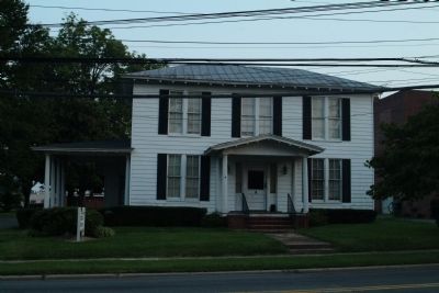
The Harden House
GEOGRAPHIC SORT Title Sort Marker Number Sort Marker Number Sort N Marker Number Sort T Publication Order Sort Publication Order Sort A Erected Year Sort Most Viewed Sort Most Recent-Interest Sort Most Recently Changed Sort SEE FAQ #33 FOR DESCRIPTIONS
On Harden Street, on the right when traveling east.
On Holt Road at Holt Street on Holt Road.
Near Southeast Court Square at East Elm St, on the right when traveling north.
On North East Court Square at East Elm Street on North East Court Square.
On Swepsonville-Saxapahaw Road at George Bason Road, on the left when traveling north on Swepsonville-Saxapahaw Road.
On East Main Street (State Highway 49), on the left when traveling west.
On State Highway 49, 1 mile south of East Greensboro-Chapel Hill Road, on the left when traveling south.
On North 5th Street (U.S. 70) at South 5th Street (North Carolina Route 119), on the right when traveling east on North 5th Street.
On Lynch Store Road at North Carolina Highway 119N, on the right on Lynch Store Road.
On State Highway 119, on the right when traveling south.
On State Highway 119 at Jim Minor Road, on the right when traveling south on State Highway 119. Reported missing.
On East Center Street at N. 7th Street, on the right when traveling east on East Center Street.
On North Carolina 119 (State Highway 119) just south of Jim Minor Road, on the right.
On East Center Street (U.S. 70) at North 5th Street, on the right when traveling west on East Center Street.
Paid Advertisement
On Church Road (State Highway 87) at Church Road, on the left when traveling south on Church Road.
Near Church Road, 0.1 miles south of Sissipahaw Way, on the left when traveling south.
On Church Road near State Highway 87, on the right when traveling east.
Near Church Road, 0.1 miles south of Sissipahaw Way, on the left when traveling south.
Near West Greensboro-Chapel Hill Road.
On East Greensboro-Chapel Hill Road, on the left when traveling east.
Near West Greensboro Chapel Hill Road just north of Sylvan School Road.
On West Greensboro-Chapel Hill Road at Pleasant Hill Church Road on West Greensboro-Chapel Hill Road.
On Drama Road, on the left when traveling east.
On East Greensboro-Chapel Hill Road.
Near Drama Road when traveling east.
On Snow Camp Road, 0.2 miles south of Greensboro-Chapel Hill Road.
On East Greensboro-Chapel Hill Road at Stockard Road on East Greensboro-Chapel Hill Road.
Paid Advertisement
Near East Greensboro Chapel Hill Road at Stockard Road, on the left when traveling east.
On East Greensboro Chapel Hill Road at Bradshaw Trail, on the left when traveling east on East Greensboro Chapel Hill Road.
On Hiddenite Church Road, 0.1 miles north of Miller Road, on the right when traveling north.
On State Highway 90, 0.2 miles west of Richard Lane (County Highway 1616), on the right when traveling west.
On State Highway 90, 0.6 miles east of Wayfound Church Road, on the right when traveling east.
On Hiddenite Church Road (County Road 1503) 0.1 miles north of Miller Road, on the right when traveling north.
On North Center Street (County Highway 1605) at Main Avenue Drive, on the left when traveling north on North Center Street.
On North Center Street (County Highway 1605) at Main Avenue Drive, on the left when traveling north on North Center Street.
On Main Avenue Drive, on the right when traveling west.
On West Main Avenue (State Highway 90) at South Center Street (County Highway 1605), on the left when traveling west on West Main Avenue.
On West Main Avenue (State Highway 90) at South Center Street (County Highway 1605), on the left when traveling west on West Main Avenue.
On Main Avenue Drive, on the right when traveling west.
On Blue Ridge Parkway (at milepost 217), 0.3 miles north of North Carolina Route 18, on the right when traveling north.
On Blue Ridge Parkway at the High Piney Spur Overlook (at milepost 218.6), 1.8 miles the Virginia state line, on the left when traveling south.
On Blue Ridge Parkway, 7 miles east of State Highway 18, on the right when traveling east.
Paid Advertisement
On State Highway 18 at State Highway 88, on the right when traveling south on State Highway 18.
On Blue Ridge Parkway (at milepost 241).
On North Main Street (U.S. 21) just north of East Whitehead Street (State Highway 18), on the right when traveling north.
On North Main Street (U.S. 21) just north of East Whitehead Street (State Highway 18), on the right when traveling north.
On North Main Street (U.S. 21) at East Whitehead Street (State Highway 18), on the right when traveling north on North Main Street.
On North Main Street (U.S. 21) just north of Whitehead Street (State Highway 18), on the right when traveling north.
Near Cherry Street just east of Grayson Street, on the right when traveling east.
On Blue Ridge Parkway (at milepost 232.5), 3 miles west of U.S. 21, on the left when traveling south.
On Blue Ridge Parkway (at milepost 236.9), on the right when traveling south.
On Main Street (U.S. 52) just south of Smith Street, on the right when traveling south.
On Main Street (U.S. 52) at Cemetery Street, on the right when traveling south on Main Street.
On Andrew Jackson Highway (U.S. 74) at Clark Mountain Road (County Route 1744), on the right when traveling west on Andrew Jackson Highway.
On U.S. 52, 0.2 miles south of Old Sneedsboro Road (North Carolina Highway 1829), on the right when traveling south.
On State Highway 52 at Old Sneedsboro Road (State Highway 1829), on the right when traveling south on State Highway 52.
On U.S. 52 at Old Sneedsboro Road (North Carolina Highway 1829), on the right when traveling south on U.S. 52.
On Andrew Jackson Highway (U.S. 74) 0.4 miles west of Boylin Road (North Carolina Highway 1420), on the right when traveling west.
Paid Advertisement
On Andrew Jackson Highway (U.S. 74) at Horne-town Road (North Carolina Highway 1259), on the right when traveling east on Andrew Jackson Highway.
On North Greene Street (North Carolina Route 109) at East Wade Street, on the right when traveling north on North Greene Street.
On Route 74 at South Main Street, on the right when traveling east on Route 74.
On North Greene Street (North Carolina Route 109) just north of West Wade Street, on the left when traveling north.
On East Caswell Street (U.S. 74) at Greenwood Lane, on the right when traveling east on East Caswell Street.
On Andrew Jackson Highway (U.S. 74) at Anson High School Road (North Carolina Highway 1259), on the right when traveling east on Andrew Jackson Highway.
On North Carolina Route 742 at Deep Creek Road, on the right when traveling south on State Route 742.
On Morven Road (U.S. 52) at Air National Guard Road (County Route 1820), on the right when traveling north on Morven Road.
On East Caswell Street (U.S. 74) at North Park Drive, on the right when traveling west on East Caswell Street.
On Healing Springs Road East, 0.3 miles east of Old Highway 16, on the right when traveling east.
On State Highway 16 at Trading Post Road, on the right when traveling south on State Highway 16.
On State Highway 16, 0.1 miles north of Charles Spencer Road (County Route 1534), on the right when traveling north.
On Rugby Road (State Highway 194) at Joe Thomas Road, on the left when traveling north on Rugby Road.
On East Main Street (State Highway 88) at Cherry Street, on the right when traveling west on East Main Street.
Near Court Street at Ashe Street, on the right when traveling east.
On Government Circle, 0.1 miles south of U.S. 221, on the right when traveling south.
Paid Advertisement
On East Main Street (Business U.S. 221) at Academy Street, on the left when traveling east on East Main Street.
On North Carolina Route 194 at Piney Creek Road, on the right when traveling north on State Route 194.
On State Highway 18 S, 1 mile south of Blue Ridge Parkway, on the right when traveling south.
On State Highway 88 at Little Peak Creek Road (Local Road 1595) on State Highway 88.
On Tobaccoville Road, on the left when traveling east.
On Todd Railroad Grade Road (State Road 1100) near Carter Miller Road, on the right when traveling south.
On Todd Railroad Grade Road (State Road 1100) west of Carter Miller Road, on the right when traveling west.
On Todd Railroad Grade Road (State Road 1100) 0.2 miles south of State Highway 194, on the right when traveling south.
On Todd Railroad Grade Road (State Road 1100) at Carter Miller Road, on the right when traveling west on Todd Railroad Grade Road.
On Carter Miller Road north of Railroad Grade Road (North Carolina Road 1100), on the left when traveling north.
On Railroad Grade Road at Cranberry Springs Road (State Road 1100) on Railroad Grade Road.
On Railroad Grade Road (State Road 1100) at South Fork Church Road, on the right when traveling south on Railroad Grade Road.
On Todd Railroad Grade Road (State Road 1100) north of South Fork Church Road, on the left when traveling north.
On Blue Ridge Parkway (at milepost 266.8), on the right when traveling south.
On Hickory Nut Gap Road (County Route 1342) west of North Carolina Highway 184, on the left when traveling west.
On Main Street West (State Highway 184/194) at Maple Court, on the right when traveling west on Main Street West.
Paid Advertisement
On Main Street West (State Highway 184/194) at Maple Court, on the right when traveling west on Main Street West.
On Linville Falls Highway (U.S. 221) at Sloop Mill Dam Road, on the left when traveling west on Linville Falls Highway.
On Miracle in the Hills Drive at North Drive, on the left when traveling north on Miracle in the Hills Drive.
On Linville Falls Highway (U.S. 221) west of Sloop Mill Dam Road, on the left when traveling west.
4877 entries matched your criteria. Entries 101 through 200 are listed above.
⊲ Previous 100 —
Next 100 ⊳