285 entries match your criteria. Entries 101 through 200 are listed.⊲ Previous 100 — The final 85 ⊳
Historical Markers and War Memorials in Scotland
By Brandon Fletcher, April 1, 2011
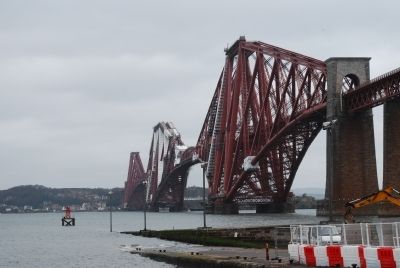
The Forth Rail Bridge
| 101 ► United Kingdom, Scotland, Edinburgh, South Queensferry — The Forth Rail Bridge — |
| On B924. | |||
| 102 ► United Kingdom, Scotland, Edinburgh, South Queensferry — The Royal Navy in the Forth — |
| On Newhalls Road at Longcraig Road, on the left when traveling east on Newhalls Road. | |||
| 103 ► United Kingdom, Scotland, Falkirk, Bonnybridge — Antonine Wall Rough Castle — |
| 104 ► United Kingdom, Scotland, Falkirk, Bonnybridge — The Antonine Wall — At Rough Castle — #1 — |
| Near Bonnyside Road. | |||
| 105 ► United Kingdom, Scotland, Falkirk — Antonine Wall — Rough Castle — |
| 106 ► United Kingdom, Scotland, Falkirk — Battle of Falkirk Muir — |
| On Greenbank Road just north of Lochgreen Road, on the left when traveling south. | |||
| 107 ► United Kingdom, Scotland, Falkirk — Captain William Edmonstone and the Dollar Family — |
| Near Manse Place just west of Vicar Street. | |||
| 108 ► United Kingdom, Scotland, Falkirk — Colonel Robert Munro — |
| Near Manse Place just east of Vicar Street when traveling west. | |||
| 109 ► United Kingdom, Scotland, Falkirk — Forth & Clyde Ship Canal — International Historic Civil Engineering Landmark — |
| Near Lime Road. | |||
| 110 ► United Kingdom, Scotland, Falkirk — Sir John de Graeme — |
| 111 ► United Kingdom, Scotland, Falkirk — Sir John De Graeme Memorial — |
| On Thornhill Road. | |||
| 112 ► United Kingdom, Scotland, Falkirk — Sir John Stewart — |
| Near Manse Place just west of Vicar Street. | |||
| 113 ► United Kingdom, Scotland, Falkirk — The Antonine Wall — At Rough Castle — #2 — |
| 114 ► United Kingdom, Scotland, Falkirk — The Bute Memorial — |
| Near Manse Place close to Vicar Street. | |||
| 115 ► United Kingdom, Scotland, Falkirk — The Northern Defences — of the Fort at Rough Castle — #3 — |
| Near Bonnyside Road. | |||
| 116 ► United Kingdom, Scotland, Falkirk — The Parish Church Graveyard — |
| On High Street. | |||
| 117 ► United Kingdom, Scotland, Falkirk — The Roman Fort — An Annex at Rough Castle — #4 — |
| 118 ► United Kingdom, Scotland, Falkirk — Wallacestone Memorial — Sir William Wallace — |
| On Standrigg Road at Wallacestone Brae, on the right when traveling west on Standrigg Road. | |||
| 119 ► United Kingdom, Scotland, Falkirk, Linlithgow — Blackness Castle — "Harbour, Castle, and Prison" — |
| Near St. Ninian's Way just north of A904. | |||
| 120 ► United Kingdom, Scotland, Fife, Anstruther — The "Battle" of May Island — |
| On East Shore just east of Haddfoot Wynd, on the right when traveling east. | |||
| 121 ► United Kingdom, Scotland, Fife, Dunfermline — Andrew Carnegie Birthplace Museum — |
| On Moodie Street. | |||
| 122 ► United Kingdom, Scotland, Fife, Dunfermline — Grave of the Mother of Sir William Wallace — 1303 A.D. — |
| Near Maygate. | |||
| 123 ► United Kingdom, Scotland, Fife, St Andrews — A Religious Powerhouse — St Andrews Cathedral — |
| 124 ► United Kingdom, Scotland, Fife, St Andrews — Lofty Beginnings — St. Rule's Church — |
| Near The Pends just east of North Street. | |||
| 125 ► United Kingdom, Scotland, Fife, St Andrews — Patrick Hamilton — |
| On North Street, on the left when traveling east. | |||
| 126 ► United Kingdom, Scotland, Fife, St Andrews — The Many Faces of St Andrews Castle — |
| On East Scores. | |||
| 127 ► United Kingdom, Scotland, Glasgow — Betrayed & Captured — William Wallace — |
| On Lumloch Road. | |||
| 128 ► United Kingdom, Scotland, Glasgow — Wallace's Well — |
| On Lumloch Road close to Cortmalow Road, on the right when traveling east. | |||
| 129 ► United Kingdom, Scotland, Highland, Ballachulish — Massacre of Glencoe Memorial — Clan MacDonald — |
| On Upper Carnoch, on the left. | |||
| 130 ► United Kingdom, Scotland, Highland, Caithness — Scrabster Harbour — |
| On Scotland Route A9 at at the end of the road, on the right when traveling north on State Route A9. | |||
| 131 ► United Kingdom, Scotland, Highland, Cromarty — HMS Natal — |
| On Marine Terrace at Bank Street, on the right when traveling north on Marine Terrace. | |||
| 132 ► United Kingdom, Scotland, Highland, Cromarty — James Thomson — |
| On High Street at Church Street, on the right when traveling east on High Street. | |||
| 133 ► United Kingdom, Scotland, Highland, Dingwall — Dingwall Boer War Memorial — |
| On High Street at Achany Road, on the right when traveling east on High Street. | |||
| 134 ► United Kingdom, Scotland, Highland, Dingwall — Dingwall Great Wars Memorial — |
| On High Street at Park Street, on the left when traveling east on High Street. | |||
| 135 ► United Kingdom, Scotland, Highland, Dingwall — Seaforth Highlanders Memorial — |
| On Station Road at High Street, on the right when traveling south on Station Road. | |||
| 136 ► United Kingdom, Scotland, Highland, Dingwall — Sergt. John Meikle — |
| On Station Road at High Street, on the right when traveling south on Station Road. | |||
| 137 ► United Kingdom, Scotland, Highland, Dingwall — Urqurhart (Ross) War Memorial — |
| On Station Road at Leanaig Road, on the left when traveling south on Station Road. | |||
| 138 ► United Kingdom, Scotland, Highland, Dornoch — Seaforth Highlanders — 1914 – 1919 — |
| On Castle Street, on the right when traveling east. | |||
| 139 ► United Kingdom, Scotland, Highland, Garve — Corrieshalloch Gorge — |
| On A832, 1 kilometer north of Route A835, on the right when traveling north. | |||
| 140 ► United Kingdom, Scotland, Highland, Invergarry — The Bridge of Oich — |
| On Scotland Route A82 at unamed road at the River Oich, on the right when traveling south on State Route A82. | |||
| 141 ► United Kingdom, Scotland, Highland, Inverness — A Castle for All Seasons — |
| Near Route A82, 3.7 kilometers south of River Enrick (Route A831), on the left when traveling south. | |||
| 142 ► United Kingdom, Scotland, Highland, Inverness — A Highland Icon — |
| Near Scotland Route A82, 3.7 kilometers south of River Enrick (Route A831), on the left when traveling south. | |||
| 143 ► United Kingdom, Scotland, Highland, Inverness — Academy of Applied Science — |
| On Scotland Route A82, 10.1 kilometers south of General Booth Road, on the left when traveling south. | |||
| 144 ► United Kingdom, Scotland, Highland, Inverness — Ardersier War Memorial — |
| On Station Road (Scotland Route B9006) at School Place, on the left when traveling north on Station Road. | |||
| 145 ► United Kingdom, Scotland, Highland, Inverness — Caisteal Ainmeal Urchadain — The Famous Castle of Urquhart — |
| On A82. | |||
| 146 ► United Kingdom, Scotland, Highland, Inverness — Chapel Yard Cemetery — |
| On Chapel Street at Friar’s Lane, on the right when traveling west on Chapel Street. | |||
| 147 ► United Kingdom, Scotland, Highland, Inverness — Culloden Battlefield — |
| On B9006, on the right. | |||
| 148 ► United Kingdom, Scotland, Highland, Inverness — Destroying the Gatehouse — |
| Near Scotland Route A82 at River Enrick (Route A831), on the left when traveling south. | |||
| 149 ► United Kingdom, Scotland, Highland, Inverness — Doocot — |
| Near Scotland Route A82, 3.7 kilometers south of River Enrick (Route A831), on the left when traveling south. | |||
| 150 ► United Kingdom, Scotland, Highland, Inverness — Flora MacDonald — |
| On Castle Road at View Place, on the left when traveling south on Castle Road. | |||
| 151 ► United Kingdom, Scotland, Highland, Inverness — Ghosts of Urquhart’s Past — |
| Near Scotland Route A82, 3.7 kilometers south of River Enrick (Scotland Route A831), on the left when traveling south. | |||
| 152 ► United Kingdom, Scotland, Highland, Inverness — Glen Urquhart War Memorial — |
| On Scotland Route A82 at Scotland Route A831, on the left when traveling south on State Route A82. | |||
| 153 ► United Kingdom, Scotland, Highland, Inverness — Inverness Castle — |
| On Castle Road at View Place, on the left when traveling south on Castle Road. | |||
| 154 ► United Kingdom, Scotland, Highland, Inverness — Inverness Castle Timeline — |
| Near Castle Road at View Place, on the left when traveling south. | |||
| 155 ► United Kingdom, Scotland, Highland, Inverness — John Cobb — |
| On Scotland Route A82, 5.5 kilometers south of River Enrick (Route A831), on the right when traveling south. | |||
| 156 ► United Kingdom, Scotland, Highland, Inverness — John Cobb Memorial — |
| On Scotland Route A82, 5.5 kilometers south of River Enrick (Route A831), on the right when traveling south. | |||
| 157 ► United Kingdom, Scotland, Highland, Inverness — Loch Ness and the Great Glen — |
| Near Scotland Route A82, 3.7 kilometers south of River Enrick (Route A831), on the left when traveling south. | |||
| 158 ► United Kingdom, Scotland, Highland, Inverness — One of Our Aircraft — |
| On Route A82, 10.1 kilometers south of General Booth Road, on the left when traveling south. | |||
| 159 ► United Kingdom, Scotland, Highland, Inverness — The Chapel — |
| Near Scotland Route A82, 3.7 kilometers south of River Enrick (Route A831), on the left when traveling south. | |||
| 160 ► United Kingdom, Scotland, Highland, Inverness — The Gatehouse — |
| Near Route A82, 3.7 kilometers south of River Enrick (Route A831), on the left when traveling south. | |||
| 161 ► United Kingdom, Scotland, Highland, Inverness — The Grant Tower — |
| Near Scotland Route A82, 3.7 kilometers south of River Enrick (Route A831), on the left when traveling south. | |||
| 162 ► United Kingdom, Scotland, Highland, Inverness — The Great Hall — |
| Near Scotland Route A82, 3.7 kilometers south of River Enrick (Route A831), on the left when traveling south. | |||
| 163 ► United Kingdom, Scotland, Highland, Inverness — The Great Kitchen — |
| Near Scotland Route A82 at River Enrick (Scotland Route A831), on the left when traveling south. | |||
| 164 ► United Kingdom, Scotland, Highland, Inverness — The Great Raid of 1545 — |
| Near Scotland Route A82, 3.7 kilometers south of River Enrick (Route A831), on the left when traveling south. | |||
| 165 ► United Kingdom, Scotland, Highland, Inverness — The Innes — |
| On Shore Street at Innes Street, on the right when traveling north on Shore Street. | |||
| 166 ► United Kingdom, Scotland, Highland, Inverness — The Magic of Loch Ness — |
| On Scotland Route A82, 10.1 kilometers south of General Booth Road, on the left when traveling south. | |||
| 167 ► United Kingdom, Scotland, Highland, Inverness — The Majesty of Loch Ness — |
| On Route A82, 10.1 kilometers south of General Booth Road, on the left when traveling south. | |||
| 168 ► United Kingdom, Scotland, Highland, Inverness — The New Kitchen — |
| Near Scotland Route A82, 3.7 kilometers south of River Enrick (Route A831), on the left when traveling south. | |||
| 169 ► United Kingdom, Scotland, Highland, Inverness — The Private Chamber — |
| Near Scotland Route A82, 3.7 kilometers south of River Enrick (Route A831), on the left when traveling south. | |||
| 170 ► United Kingdom, Scotland, Highland, Inverness — The Service Close — |
| Near Scotland Route A82, 3.7 kilometers south of River Enrick (Scotland Route A831), on the left when traveling south. | |||
| 171 ► United Kingdom, Scotland, Highland, Inverness — The Stables — |
| Near Scotland Route A82, 3.7 kilometers south of River Enrick (Route A831), on the left when traveling south. | |||
| 172 ► United Kingdom, Scotland, Highland, Inverness — The Trebuchet — |
| Near Scotland Route A82, 3.7 kilometers south of River Enrick (Route A831), on the left when traveling south. | |||
| 173 ► United Kingdom, Scotland, Highland, Inverness — The Water Gate — |
| Near Scotland Route A82, 3.7 kilometers south of River Enrick (Route A831), on the left when traveling south. | |||
| 174 ► United Kingdom, Scotland, Highland, Inverness — Upstream, downsteam — |
| On Castle Road at View Place, on the left when traveling south on Castle Road. | |||
| 175 ► United Kingdom, Scotland, Highland, Inverness — Urquhart the Defiant — |
| Near Scotland Route A82, 3.7 kilometers south of River Enrick (Route A831), on the left when traveling south. | |||
| 176 ► United Kingdom, Scotland, Highland, Lairg — A geological sandwich — |
| On Scotland Route A894, 2.4 kilometers south of the Kylesku Bridge, on the left when traveling south. | |||
| 177 ► United Kingdom, Scotland, Highland, Lairg — A moving story — |
| On Route A838, 25.3 kilometers south of the village of Durness, on the left when traveling south. | |||
| 178 ► United Kingdom, Scotland, Highland, Lairg — Ardvreck Castle — |
| On Scotland Route A837, 1.3 kilometers south of Scotland Route A894, on the right when traveling south. | |||
| 179 ► United Kingdom, Scotland, Highland, Lairg — Calda House — |
| On Route A837, 2.1 kilometers south of Route A894, on the right when traveling south. | |||
| 180 ► United Kingdom, Scotland, Highland, Lairg — Causeway — |
| On Scotland Route A838, 3.2 kilometers west of Scotland Route A836 when traveling west. | |||
| 181 ► United Kingdom, Scotland, Highland, Lairg — Ceannabeinne — |
| On Scotland Route A838, 43.4 kilometers west of Scotland Route A836, on the left when traveling west. | |||
| 182 ► United Kingdom, Scotland, Highland, Lairg — Ceannabeinne Township Trail — |
| On Scotland Route A838, 45.1 kilometers west of Scotland Route A836, on the right when traveling west. | |||
| 183 ► United Kingdom, Scotland, Highland, Lairg — Ceannabeinne Township Trail — Houses and Homes – Life begins to get better — |
| On Scotland Route A838, 45.1 kilometers west of Scotland Route A836, on the right when traveling west. | |||
| 184 ► United Kingdom, Scotland, Highland, Lairg — Cultural Landscape — |
| On Scotland Route A837, 1.3 kilometers south of Scotland Route A894, on the right when traveling south. | |||
| 185 ► United Kingdom, Scotland, Highland, Lairg — Durness — |
| On Scotland Route A838 at where A838 turns left toward Rhiconich, on the left when traveling west on State Route A838. | |||
| 186 ► United Kingdom, Scotland, Highland, Lairg — Durness War Memorial — |
| On Scotland Route A838 at where A838 turns left toward Rhiconich, on the left when traveling west on State Route A838. | |||
| 187 ► United Kingdom, Scotland, Highland, Lairg — Glacier detectives — |
| On Scotland Route A837, 5 kilometers south of Scotland Route A894, on the right when traveling south. | |||
| 188 ► United Kingdom, Scotland, Highland, Lairg — Green and pleasant land — |
| On Scotland Route A835, 4.8 kilometers south of Scotland Route A837, on the right when traveling south. | |||
| 189 ► United Kingdom, Scotland, Highland, Lairg — Keoldale Green — |
| On Route A838 at Unnamed Road to Keoldale, on the right when traveling south on Route A838. | |||
| 190 ► United Kingdom, Scotland, Highland, Lairg — Kyle of Tongue Crossing — |
| On Scotland Route A838, 3.2 kilometers west of Scotland Route A836, on the left when traveling west. | |||
| 191 ► United Kingdom, Scotland, Highland, Lairg — Kylesku Bridge — |
| On Scotland Route A894 at the Kylesku Bridge, on the right when traveling south on State Route A894. | |||
| 192 ► United Kingdom, Scotland, Highland, Lairg — Mark of Gratitude — |
| On Scotland Route A838, 13.8 kilometers south of the village of Durness, on the right when traveling south. | |||
| 193 ► United Kingdom, Scotland, Highland, Lairg — Stories in sand — |
| On Scotland Route A838 at Unnamed Road to Keoldale, on the right when traveling south on State Route A838. | |||
| 194 ► United Kingdom, Scotland, Highland, Lairg — X Craft Memorial — |
| On Route A894 at the Kylesku Bridge, on the right when traveling south on Route A894. | |||
| 195 ► United Kingdom, Scotland, Highland, Lybster — Lybster and Swiney War Memorial — |
| On Quatre Bras (Scotland Route A99) at Village Road, on the left when traveling west on Quatre Bras. | |||
| 196 ► United Kingdom, Scotland, Highland, Lybster — Patrick Sinclair — |
| On Quatre Bras (Scotland Route A99) at Village Road, on the left when traveling east on Quatre Bras. | |||
| 197 ► United Kingdom, Scotland, Highland, Muir of Ord — Muir of Ord — |
| On Geat N Road (Scotland Route A862) at Black Isle Road, on the left when traveling south on Geat N Road. | |||
| 198 ► United Kingdom, Scotland, Highland, Munlochy — Knockbain Great Wars Memorial — |
| On Scotland Route B9161, 1.8 kilometers south of unnamed road (Scotland Route A832), on the right when traveling south. | |||
| 199 ► United Kingdom, Scotland, Highland, Nairn — Balnuaran of Clava — a prehistoric cemetery — Clava Cairns — |
| On National Cycle Rte 7. | |||
| 200 ► United Kingdom, Scotland, Highland, Nairn — Nairn Fishwife — |
| On Harbour Street at the River Nairn, on the left when traveling east on Harbour Street. | |||
285 entries matched your criteria. Entries 101 through 200 are listed above. ⊲ Previous 100 — The final 85 ⊳