Interstate 15 is the latest in a series of roads that have traversed this area since prehistory. Although used for generations by Native Americans, the first recorded use of this route was by the Lewis and Clark Expedition on August 10, 1805. They . . . — — Map (db m124333) HM
Few points along the route of the Lewis and Clark Expedition have the significance of this site, now beneath the waters of Clark Canyon Reservoir. Noted on their maps as "Fortunate Camp", the Lewis and Clark Expedition journeyed here hoping to . . . — — Map (db m124302) HM
Sidney Edgerton arrived at Bannack from Ohio in September 1863 to begin his appointment as Chief Justice of the Supreme Court of Idaho Territory. The massive territory encompassed Idaho, all of Montana, and the western half of Wyoming, with the . . . — — Map (db m124263) HM
Lewis and Clark Trail 1806
First important gold camp 1862
Scene of vigilante activities 1863
First capital Territory of Montana 1864-1865
First county seat of Beaverhead County 1864-1881
In grateful memory of the early pioneers who . . . — — Map (db m49535) HM
Montana's first gold rush began near here at Grasshopper Creek in the summer of 1862. Prospectors John White and company camped along the insect infested banks as they looked for a shortcut to the Deer Lodge valley. They panned the gravel - as was . . . — — Map (db m124290) HM
Lewis and Clark Trail 1806. First Important Gold Camp 1862. Scene of Vigilante Activities 1863. First Capital Territory of Montana 1864-1865. First County Seat of Beaverhead County 1864-1881. In grateful memory of the early pioneers who founded our . . . — — Map (db m145711) HM
Bannack epitomizes the tough, primitive towns that sprang up with gold discoveries. Its story also illustrates a century of survival, through boom and bust periods associated with resource extraction and technological advances. On July 28, 1862, . . . — — Map (db m124262) HM
This Plaque and Chimes Installed to the Glory of God in Memory of Beaverhead County Boys Who Gave Their Lives in World War II
Raymond Arrigoni • James Barlow • William Bender • Phil Burke • Thomas Butler • Frank Buyan • LaRue Cantrell . . . — — Map (db m180755) WM
The prominent geological feature to the west is called Beaverhead Rock. On the afternoon of August 8, 1805, members of the Lewis and Clark Expedition pulled its canoes up the Beaverhead River toward the Continental Divide. They sighted what . . . — — Map (db m193249) HM
By the time the Corps of Discovery passed through here, the "Valley of the Beaverhead" was already common ground for many Indian tribes. The Beaver's Head was a well-known landmark not only to the Shoshone but other Rocky Mountain tribes who passed . . . — — Map (db m193247) HM
The City Hall building was built in 1914. The ground where the building sits was purchased from David Robb for $4,450. It was designed by renowned architect Fred R. Willson and built by contractor William Reed. Construction began in April 1914 and . . . — — Map (db m180694) HM
This monument design is taken from the small pocket compass carried by William Clark on the expedition. Clark’s compass was made by Thomas Whitney in Philadelphia.
Fortunate Chapter of the National Lewis and Clark Trail Heritage Foundation . . . — — Map (db m128185) HM
The four buildings that make up this small historic district show the growth of Dillon’s city government. Buildings include ones constructed in the Progressive Era, the New Deal, and the 1960s, when the city built a shelter for one of its water . . . — — Map (db m180751) HM
Built in 1902, this building was the second location of the Dillon Implement Company, a company that was founded in August of 1886. The first location was north of the Union Pacific Depot on Montana St. The second building was constructed from stone . . . — — Map (db m180752) HM
This tablet marks the site of the first public school building which was also used for the first court house-theatre and library in Dillon
Dedicated to the pioneers of the valley on the fiftieth anniversary of the founding of Dillon.
Placed by . . . — — Map (db m145700) HM
Your observations are to be taken with great pains & accuracy, to be entered distinctly & intelligibly for others as well as yourself, to comprehend all the elements necessary —President Thomas Jefferson
On August 13, 1805 William . . . — — Map (db m128184) HM
This site was the pivotal point in the success of the Lewis and Clark Expedition. The party camped here in August 1805. They cached their boats and aided by the influence of Sacajawea obtained horses from her people the Shoshone Indians
The Great . . . — — Map (db m124304) HM
In midsummer, 1862, John White and party discovered gold on this creek several miles down stream. The first major gold rush to what is now Montana resulted. — — Map (db m124264) HM
The Andrus Hotel was built to be a first-class establishment to serve the City of Dillon and to accommodate train travelers in the ares. Jesse M. Warren, a well known Butte Architect, designed the building for construction. Dar Hardware of Dillon . . . — — Map (db m209430) HM
The Lewis and Clark Expedition passed this way going west August, 1805 and returning July, 1806.
‘Though the Pathfinder may die, the paths remain open.’
Beaverhead Chapter Daughters of the American Revolution. June 14, 1928 — — Map (db m145710) HM
Instruments for ascertaining, by celestial observations, the geography of the country through which you will pass, have been already provided. —President Thomas Jefferson
The data collected by Lewis and Clark is a striking indicator . . . — — Map (db m128183) HM
The Martin Barrett House, built in 1912, was the in-town retirement home of prominent pioneer rancher, politician and philanthropist Martin Barrett and his wife Alice. One of the finest examples of early-twentieth-century architecture in Dillon, the . . . — — Map (db m209432) HM
It was acquire many years ago in the mountains southwest of Dillon, MT. The tree could be as much as 500 years old. The Sheepeaters placed a mountain sheep skull in the crotch of a tree, and over a hundred years or more the tree grew around it. . . . — — Map (db m180689) HM
The Nez Perce camped near here on Horse Prairie Creek, Aug. 12 1877 following the Battle of the Big Hole Aug. 9-10. General Howard was summoned when beating drums arroused [sic] the citizens of Bannack. Women and children were quartered in the Meade . . . — — Map (db m49537) HM
Interstate 15 is the latest in a series of roads that have traversed this area since prehistory. Although used for generations by Native Americans, the first recorded use of this route was by the Lewis and Clark Expedition on August 10, 1805. They . . . — — Map (db m124291) HM
”…you will take careful observations of …objects distinguished by such natural marks & characters of a durable kind…”
—President Thomas Jefferson
There is a remarkable view from the crest of Clark's Lookout and it is . . . — — Map (db m128182) HM
In Commemoration of
Sacajawea
who guided Lewis and Clark through this
the land of her childhood and capture
On August 17th, 1805 she rejoined her tribe near this site. The services she rendered the expedition were invaluable. . . . — — Map (db m124293) HM
The waters of the Beaverhead River opened this southern gateway to Montana through which have passed:
Ancient Indian Trail
Lewis and Clark Expedition 1805-1806
First Missionary, Father DeSmet 1840
Great Beaverhead Wagon Toll Road . . . — — Map (db m145713) HM
In 1804-06, Captains Meriwether Lewis and William Clark led about 40 soldiers and boatmen on an epic journey. President Thomas Jefferson commissioned this “Corps of Discovery” to find a route to the Pacific Ocean through the newly acquired Louisiana . . . — — Map (db m124305) HM
William Clark was central to the success of the Corps of Discovery expedition not only during the two years spent crossing the continent but also because he produced maps of the west long after his return.
His three maps of the Western United . . . — — Map (db m128181) HM
"the road took us to the most distant fountain of the waters of the mighty Missouri in surch (sic) of which we have spent so many toilsome days and wristless (sic) nights." - Meriwether Lewis, August 12, 1805
What's in a name? . . . — — Map (db m109502) HM
"two miles below McNeal had exultingly stood with a foot of each side of this little rivulet and thanked his god that he had lived to bestride the mighty & heretofore deemed endless Missouri." - Meriwether Lewis, August 12, 1805
Hugh . . . — — Map (db m109500) HM
In 1806, Captain William Clark and his crew traveled through here on horseback moving quickly on their return trip to St. Louis. Arriving at present day Jackson Hot Springs in the afternoon of July 7th, they stopped to experiment with cooking in the . . . — — Map (db m124223) HM
On their return journey, the Corps of Discovery divided into two groups at Traveler's Rest, near present day Lolo, Montana. Captain William Clark and his party traveled through today's Big Hole Valley on their way to Camp Fortunate to recover their . . . — — Map (db m124260) HM
For generations the Hamilton Ranch was widely-known as the Carroll Ranch - and it served as a vital link between the Big Hole and Beaverhead valleys. Its location at the base of this mountain pass made the ranch a perfect stopping point for . . . — — Map (db m124225) HM
Meriwether Lewis is hardly the only person ever to have found himself evaluating the meaning and purpose of his own life. But the words he wrote on the evening of August 18, 1805 - when camped about 35 miles southeast of where you stand now - have . . . — — Map (db m124227) HM
Ranching, anchored in the natural productivity of rangelands, is one of the main reasons so much or the landscape surrounding you still looks as it did centuries ago. The climate here is too harsh for farming, but native rangeland vegetation is . . . — — Map (db m124228) HM
Undaunted Stewardship® is a statewide partnership involving 19 agricultural and conservation groups in Montana, managed and directed by Montana State University, the Montana Stockgrowers Association and the federal Bureau of Land Management. The . . . — — Map (db m124243) HM
On a clear day, the sweeping views from here take in more than 400 square miles. Most of these lands look much as they have for centuries. Human travel routes haven't changed much either. Highway 278 mirrors very closely that Captain Clark and his . . . — — Map (db m124222) HM
The Department of Transportation launched an ambitious program in 1936 to promote the state's scenic, recreational, and historical treasures. The brainchild of department engineer Bob Fletcher, the program included roadside historical markers, . . . — — Map (db m124334) HM
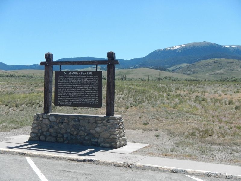
This area once echoed with the sound of creaking wagon wheels, cracking whips, and profanity so intense the mountains vibrated with sulfur! The old wagon road between Montana and Utah passed very close to this rest area. It first saw use in the . . . — — Map (db m124336) HM
About four million years ago, this part of the North American Plate slid over a gigantic source of heat in the mantle known as the Yellowstone hot spot. In Yellowstone National Park, this heat is responsible for the geysers, mud pots, and hot . . . — — Map (db m124335) HM
(Two panels are on this interpretive stand:)
July 8, 1806
The Way It Used To Be... Way Back
Just over two hundred years ago...
We proceeded down Willards Creek on the S.W. Side about 11 miles...The Country . . . — — Map (db m124268) HM
Pursued by the U.S. Army since June 1877, approximately 800 Nez Perce (nimi•pu•) men, women, and children traveled over the Bitterroot Mountains and camped here in the Big Hole Valley. Thinking there was no immediate pursuit by the Army, this . . . — — Map (db m123743) HM
"on each side of those glades the timber is small and great proportions of it killed by the fires" - William Clark, July 8 1806
Two hundred years ago William Clark saw a forest of young trees, many killed by fire. Very open stands of . . . — — Map (db m123740) HM
From this vantage point you can visualize the general progress of the Battle of the Big Hole, but at a distance from the fear and chaos of its hand-to-hand combat. The landscape has changed little since the morning of August 9, 1877. This lush . . . — — Map (db m123741) HM
(Inscriptions are found on three sides of this monument.)
On This Field
17 officers and 133 enlisted men of
the 7th U.S. Infantry
under its Colonel
Bvt. Major General John Gibbon with 8 other
soldiers and 36 citizens . . . — — Map (db m123812) WM
Across the valley is the Continental Divide and the beautiful Bitterroot Mountains. The famous Big Hole River winds through the valley that is noted for abundant hay, fine cattle and horses, great hunting and fishing, beautiful scenery and friendly . . . — — Map (db m124221) HM
To the
everlasting
Memory of the
Brave Warriors of
Chief Joseph's Band
who fought on
these grounds
in the
Nez Perce War
of 1877
In Memory of
the Indians, Infants,
Children, Women
and Old Men
who . . . — — Map (db m123755) HM
(Three panels make up this informational marker:)
Natural Travel Corridor
Clark's 1806 Route
Captain Clark and his party found great quantities of camas just beginning to bloom when they passed here on Sunday July 6, 1806. . . . — — Map (db m123738) HM
In front of you on the morning of August 9, 1877, you would have seen soldiers and Montana volunteers pass by as they began to deploy for the coming attack on the Nez Perce encampment just through the trees.
Following the army's surprise attack, . . . — — Map (db m123745) HM
"In grateful recognition of the valor and sacrifice of the soldiers killed in action fought on these grounds, between the United States Forces under General George Crook and Sioux and Cheyenne Indians under Chief Crazy Horse. June 17, 1876. 3rd U.S. . . . — — Map (db m221578) HM WM
On August 10, 1983 a prairie fire swept over the battlefield, burning nearly 600 acres of dense, thick vegetation. In May and June of 1984 the National Park Service began an unprecedented systematic archeological survey of the Custer Battlefield. . . . — — Map (db m86810) HM
In memory of enlisted men 2nd and 7th U. S. Cavalry and 5th U. S, Infantry killed in action near Bear Paw, Montana September 30, 1877 < Left Side of Monument : > 7th U. S. Cavalry Troop A 1st Serg’t Geo. McDermott Serg’t Otto Derglew . . . — — Map (db m86873) HM
This monument was originally erected at Ft. Keogh in 1881 to honor U.S. Army casualties from the 1877 Nez Perce War. PLEASE NOTE: “Hostile Indians” is in historical context with a term used for Native American enemies of the United . . . — — Map (db m86865) HM
This position was held by Co. L commanded by Lt. James Calhoun. It may have been used to hold off Chief Gall and his Sioux warriors and thus protect Custer's advance. From here these soldiers could have attracted Capt. Benteen's column and the pack . . . — — Map (db m21643) HM
After separate skirmishing, Custer’s command reunites here. Company L, under Lt. James Calhoun, skirmishes with Gall, Crow King, Two Moons, and other warriors. From here these soldiers could have attracted Capt. Benteen’s column and the pack . . . — — Map (db m86838) HM
After the battle, Sioux and Cheyenne removed their dead and buried them in tipis, scaffolds, and adjacent hillsides in the Little Bighorn valley. Southern Cheyenne Chief “Ve’ho’enohnenehe” (Lame White Man) and Northern Cheyenne . . . — — Map (db m86860) HM
Plagued with the loss of the great buffalo herds, the confinement to reservations, disease, famine, and poverty, Chief Plenty Coups led the Crow people through a painful transition. Gifted with vision, the power of impressive speech, . . . — — Map (db m85999) HM
The white markers on the knolls and in the ravines to the west and southwest show were the troopers of Co, C under Capt. Tom Custer and Co. E under Lt. Smith were found. The Indian encampment lay beyond on the flat across the river. — — Map (db m21645) HM
From this promontory 13 miles away in the Wolf Mountains, Custer's scouts observe the Lakota, and Cheyenne pony herd and evidence of a large village in the valley behind you. Convinced the Indians had spotted his regiment and would soon scatter, . . . — — Map (db m45580) HM
From the Crow’s Nest, a vantage point 14 miles away in the Wolf Mountains, Custer’s Crow and Arikara scouts saw evidence of the massive Lakota, Cheyenne, and Arapaho encampment. Convinced that he was discovered, Custer abandoned plans for a . . . — — Map (db m86817) HM
After the brief encounter near the river, Custer’s two companies retreat up the ravine to your right known as Deep Coulee. The remainder of Custer’s command skirmishes with warriors on the high ridge ½ mile to your right. Seizing the . . . — — Map (db m86831) HM
Deep Ravine (Crazy Horse Gully & Grey Horse Ravine) was the scene of fierce fighting during the battle. Crazy Horse, and other Sioux and Cheyenne warriors crossed the Little Bighorn River (in front of you) and rode up the ravine during the attack . . . — — Map (db m86800) HM
Custer’s command deploys in the current national cemetery area and advances into the basin across the road to your left before withdrawing to Last Stand Hill. Toward the conclusion of the battle, soldiers from Company E moved toward the Deep . . . — — Map (db m86839) HM
Warriors ascend the large ravine behind you pursuing Custer’s troops. Soldiers retreat through the area to your front and right. Indians position themselves along the ridge to your left knows as Greasy Grass Ridge. Archeologists discovered numerous . . . — — Map (db m86834) HM
Custer National Cemetery, like Arlington National Cemetery, provides a final resting place for many generations of those who faithfully served in the United States armed forces. Here, Americans of many races and beliefs rest side by side. Relive . . . — — Map (db m86846) HM
On June 25, 1876, approximately 7,000 Lakota, Cheyenne, and Arapaho, including 1,500 – 2,000 warriors, encamped below on the Greasy Grass River (Little Bighorn). Under the political and spiritual leadership of Tatanka-Iyotanka (Sitting Bull), . . . — — Map (db m86814) HM
An Indian memorial to honor Native American participation in the Battle of the Little Bighorn, June 25-26, 1876, and change the name of Custer Battlefield National Monument to Little Bighorn National Monument, was authorized by Congress in 1991 . . . — — Map (db m86804) HM
The Indian charge shatters the Calhoun defense and crashes through the soldier position at right, held by Capt. Myles Keogh’s Company I, Crazy Horse and White Bull cut down the retreating soldiers who flee northwest along this ridge in an effort to . . . — — Map (db m86811) HM
This knoll was contested by Indians and soldiers. Some evidence indicates soldiers of Company C occupied this position since bodies of Sergeants Finckle and Finley were found here. Indian testimony suggests that Southern Cheyenne war leader Lame . . . — — Map (db m86836) HM
Lakota, Cheyenne, and Arapaho warriors surrounded this position near the climax of the battle. Lt. Col. George Armstrong Custer and approximately 41 men, shoot their horses for breastworks and fight to the death. Custer and several soldiers were . . . — — Map (db m86801) HM
This area was occupied by troops A, B, D, G, H, K, and M, 7th. U.S. Cavalry, and the pack train when they were besieged by the Sioux Indians June 25th and 26th 1876. — — Map (db m21636) HM
(Bottom of Marker):
In memory of
Officers and soldiers who fell near this place
fighting with the 7th United States Cavalry
against the Sioux Indians
on the 25th and 26th of June,
A.D. 1876
(The rest of the marker includes . . . — — Map (db m7022) HM
Arikara “I shall not see you (sun) go down behind the mountains tonight . . .I am going home today, not the way we came, but in spirit, home to my people.”- Bloody Knife, Arikara (June 25, 1876) “These Old Scouts, . . . — — Map (db m87723) HM
Advancing down Reno Creek, Custer pauses at a tipi located behind this ridge. The tipi contains the remains of a Sans Arc warrior killed a week before at the Battle of the Rosebud. Indians flee toward the village, prompting Custer to order Reno's . . . — — Map (db m45581) HM
After leaving Cedar Coulee, Custer descends toward the Little Bighorn River in the ravine ahead known as Medicine Tail Coulee. Custer probably again divides his command: three companies likely ascend to the higher ridges beyond. Two companies . . . — — Map (db m86824) HM
As soldiers descend Medicine Tail Coulee, the Minniconjou and Cheyenne camps were on the western bank. Archeological evidence supports Indian testimony, that initial fighting took place on the flats near the river to your left and cutbank directly . . . — — Map (db m86827) HM
Following the battle, the Lakota and Cheyenne removed their dead and buried them in lodges, scaffolds, and the hillsides. Surviving members of the 7th Cavalry hastily buried the soldiers, Indian Scouts, and civilians on June 28, 1876. In 1877, . . . — — Map (db m86844) HM
This National Cemetery, established in 1886, is for interment of those who served honorably in the Armed Forces of the United States. their immediate families also have burial privileges.Many from indian battles of the northwest are buried here. . . . — — Map (db m45551) HM
Indian descendants of participants in the Battle of the Little Bighorn helped form the vision of the Indian Memorial. The “Peace Through Unity” theme was conceived by the late Enos Poor Bear, Sr. and Austin Two Moons. Together, they . . . — — Map (db m86806) HM
Under mounting pressure, Reno abandons the timber. His retreat disintegrates into a rout as pursuing warriors ride in amongst the troopers killing more than 30 soldiers. Indian casualties are few. Lakota and Cheyennes drive the cavalry across the . . . — — Map (db m86821) HM
After fording the Little Bighorn River one mile to your left, Reno’s battalion gallops down the valley below. Convinced he is vastly outnumbered, Reno dismounts, and forms a skirmish line across the valley floor, firing into the lodges. Warriors . . . — — Map (db m86819) HM
Reno's battalion of 175 soldiers, civilian personnel, and Arikara and Crow Scouts halt in the valley and form a thin skirmish line. Warriors race out from the village to oppose him. After 10 minutes of fighting Lakota and Cheyenne warriors outflank . . . — — Map (db m45583) HM
During Reno's retreat from the timber, Crazy Horse, Wooden Leg, Black Elk, and perhaps as many as 600 warriors chase the soldiers across the Little Bighorn River. Reno's casualties are 40 men killed and 13 wounded. The remnants of Reno's command . . . — — Map (db m45584) HM
After the battle, 39 cavalry horses that had been shot for breastworks during Custer’s Last Stand, were found among the dead on Last Stand Hill. In 1879, a temporary cordwood monument was erected by the Army on the crest of the hill. The area, . . . — — Map (db m45604) HM
June 25-26, 1876 - From the ridge to your right, Custer first views the village. Needing more information about the extent of the encampment, he moves further north. After witnessing the beginning of Reno's charge, Custer's five companies descend . . . — — Map (db m45587) HM
After an unsuccessful attack on the Indian camp in the valley, Major Reno and his battalion retreated to this vicinity where they were soon reinforced by Captain Benteen's battalion and the pack train. In an attempt to find and rejoin Custer they . . . — — Map (db m45554) HM
Reno occupies a defensive position in the timber. Determined to defend their village, warriors soon penetrate the woods, convincing Reno that the position is untenable. After fighting for 30 minutes, Reno retreats across the Little Bighorn River. — — Map (db m45585) HM
In an attempt to locate Custer, Company D under Captain Thomas Weir advances to this hilltop position without orders late on June 25. Weir may have witnessed the conclusion of the battle three miles ahead. He is later joined by Captain Benteen and . . . — — Map (db m86823) HM
This is the farthest point reached by Capt. Weir in his attempt to assist Custer. Minutes after arriving, his company was joined by Capt. Benteen's company and others. They remained about 45 minutes until mounting warrior pressure forced them back . . . — — Map (db m21640) HM
The hill in front of you was occupied by Lakota, and Cheyenne during the fight on Last Stand Hill. An unknown Sioux warrior wearing a warbonnet was killed here while firing his rifle at soldiers positioned behind a horse barricade on the crest of . . . — — Map (db m45593) HM
Be silent, close you eyes, and listen to the breeze as it rustles through the prairie grasses. To many, the whispering sounds make this a spiritual place. Hunans have defined this lans by its uses and the emotions it stimulates.
First . . . — — Map (db m189806) HM
"They made us many promises, more than I can remember, but they never kept but one: they promised to take our land and they took it." - Chief Red Cloud, Oglala Sioux
Major Conflicts of the Plains Indian War
August 19, 1854 Gratten . . . — — Map (db m189765) HM
2181 entries matched your criteria. The first 100 are listed above. Next 100 ⊳