On Main Street (Route 11), on the right when traveling north.
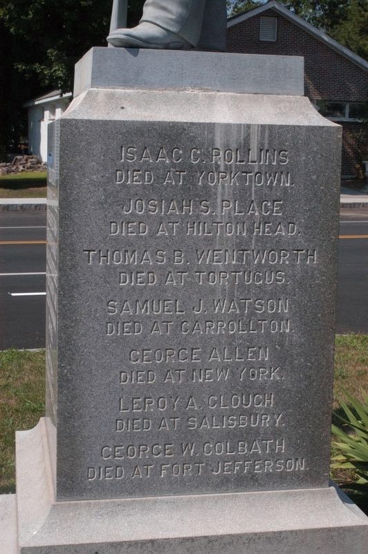
Main inscription Dedicated to the memory of those who enlisted from Alton in the War of 1861-65. Died in defense of their country and sleep in unknown graves. Erected by M.H. Savage Post GAR
Side 1 Issac C. Rollins Died at Yorktown . . . — — Map (db m96739) WM
On Main Street (New Hampshire Route 11), on the right when traveling north.
Main inscription Viet Nam Conflict Honor Roll
followed by 2 rows of 70 names.
Reverse inscription Dedicated Mar 30 1987 Erected by Town of Alton and American Legion Post 72 — — Map (db m96743) WM
On Main Street (New Hampshire Route 11), on the right.
Honor Roll
This memorial is dedicated to the men and women who served their country for the cause of freedom
1941 World War II 1945 4 rows of names are inscribed.
Those who made the supreme sacrifice 8 names are inscribed.
1950 Korea 1953 . . . — — Map (db m96745) WM
On Main Street (New Hampshire Route 11), on the right.
Erected by the town of Alton N.H. honor roll of her soldiers and sailors 1914 World War I 1919
Top row: 3 names with Stars
Then 4 rows of inscribed names
*Died in the service of our country — — Map (db m96747) WM
This location became a transportation center on August 30, 1851, upon completion of the Cocheco Railroad from Dover to Alton Bay. The first "Mount Washington" steamboat was built here in 1872. For forty years a railroad terminus, here northbound . . . — — Map (db m96751) HM
On S Barnstead Road (New Hampshire Route 126) north of Gray Road, on the left when traveling north.
This patriot and civic leader rests in a nearby grave on land he once farmed. In 1764 he contracted to build Barnstead's portion of the Province Road. On December 14-15, 1774 he participated in raids on the British Fort William and Mary in New . . . — — Map (db m235107) HM
On Depot Street (New Hampshire Route 140) at Johnson Street, on the right when traveling east on Depot Street.
Belmont Mill
The Gilmanton Village Manufacturing Co., under
the leadership of Gov. William Badger, built
the Belmont Mill in the 1830s. It first produced
cotton cloth, but was converted to hosiery
knitting in 1865. In 1885, it had the . . . — — Map (db m261113) HM
Near Depot Street (New Hampshire Route 140) west of Main Street, on the left when traveling west.
From 1889 to 1929 the Belmont Spur Railroad ran from
Tilson Junction to serve Belmont and its Mill. The route
crossed from the Winnipesaukee River on a wooden
trestle bridge below Silver Lake and then crossed the
Tioga River twice. The final . . . — — Map (db m261115) HM
On Main Street 0.1 miles south of Plymouth Street ( Route 25B), on the right when traveling north.
Founders Dr. Royal M. Frye and Dr. Virginia M. Brigham were visionaries, educators, and mentors who brought together faculty, administrators and students for an outstanding education. While Degrees were earned, all who attended gained lifelong . . . — — Map (db m97063) HM
On New Hampshire Route 25, on the right when traveling south.
Author and publisher of almanacs first appearing in 1797. Best known was "Leavitt's Farmers' Almanac and Miscellaneous Year Book" which was continued after his death for about 45 years. This publication provided
information vital to domestic and . . . — — Map (db m235449) HM
On New Hampshire Route 107, on the right when traveling north.
One of the earliest highways in New Hampshire, it was authorized in 1765 as a supply route from the tide-water port of Durham to the colony's northern settlements in the Coos. This section of the road through Gilmanton was built in 1770 nine . . . — — Map (db m235104) HM
Near Endicott Street (U.S. 3) east of Lakeside Avenue, on the right when traveling west.
National Society
Women Descendants
Ancient and Honorable
Artillery Company
Massachusetts
1637 — 1774
Honors Two Charter Members
John Endicott and Edward Johnson
Captain Johnson surveyed
this area in 1652
for the . . . — — Map (db m282505) HM
On Endicott Street (U.S. 3) east of Lakeside Avenue, on the right when traveling west.
Endicott Rock
the name of
John Endicvt Gov.
and the initials of
Edward Johnson and Simon Willard, Commissioners
of the Massachusetts Bay Colony,
John Sherman and Jonathan Ince, Surveyors,
were inscribed upon this rock
August . . . — — Map (db m308750) HM
On Main Street, on the right when traveling south.
In honor of the 12th Regt. NH Vols. who fought in the war of 1861-1865 for the preservation of the Union. Erected by Major E.E. Bedee — — Map (db m96730) WM
1941-1945 Meredith Honor Roll
There are 3 panels of inscribed names, with 4 starred names, indicating they gave their lives in the conflict — — Map (db m96732) WM
On Silver Lake Road east of River Road, on the left when traveling east.
The history of Lochmere, in the broadest sense, is the history of human use of the Winnipesaukee River. Navigable by canoe, the river served as a major transportation and communications route and, with falls and rapids, it has served as a source . . . — — Map (db m261116) HM
On West Main Street (U.S. 3) at Winter Street, on the right when traveling east on West Main Street.
Native Charles E. Tilton shaped his hometown through his many gifts of monuments, buildings and parks – places that make the community special today. After moving to the West Coast in 1850, Tilton acquired extraordinary wealth through his trading . . . — — Map (db m261118) HM
Near West Main Street (U.S. 3) at Winter Street, on the left when traveling west.
Situated on the Winnipesaukee River, the town of Tilton was a prime location for a variety of mills in the late eighteenth and early nineteenth centuries. The products produced in Tilton during the height of the mill manufacuring period included . . . — — Map (db m97228) HM
Near West Main Street (U.S. 3) at Winter Street, on the left when traveling west.
In 1850, approximately 100 years after the town of Sanbornton was settled, a group of citizens petitioned to form a new town. Voted on at a special town meeting in 1869, and approved by the voters and the governor of N.H., the town of Tilton was . . . — — Map (db m97229) HM
Near West Main Street (U.S. 3) at Winter Street, on the left when traveling west.
In the eighteenth and nineteenth century, the power of the Winnipesuakee River was harnessed to operate mills up and down its banks. These banks were home to several gristmills, woolen mills, and other textile mills. Many dams existed in this . . . — — Map (db m97231) HM
On Main Street (U.S. 3) at School Street, in the median on Main Street.
In honor of those from the town of Tilton who devoted themselves to the cavse of freedom in the service of ovr covntry --1914-1919 -- They served without thovght of self that the principles of liberty, jvstice and eqvality might prevail for all . . . — — Map (db m97194) WM
On Passaconaway Road east of Kancamagus Highway ( Route 112), on the right when traveling east.
Today a trip to town takes minutes.
For homesteaders, traveling the bumpy 15 miles to Conway by wagon took 3 hours, on a good day.
Trips to the store would not have been casual affairs, but a chance to stock up on supplies.
50 lb. sacks . . . — — Map (db m116172) HM
Near Passaconaway Road east of Kancamagus Highway ( Route 112) when traveling east.
Local Ideas
Builder Amzi Russell who lived at what is now the Russell-Colbath homestead, was an industrious and versatile nearby builder.
His crew of three to thirty local hands were not engineers. But they were extremely skilled craftsmen . . . — — Map (db m116180) HM
Near Kancamagus Highway (State Road 112) 2.9 miles west of Passaconaway Road, on the right when traveling west.
When the railroads came to Conway
In 1864, the White Mountains became more accessible to tourists when the Boston & Maine Railroad brought its lines into Conway. The grueling three-day stagecoach journey from Boston became an easy four-hour . . . — — Map (db m259174) HM
On Main Street (U.S. 302) at Albany Avenue, on the left when traveling west on Main Street.
This snow roller, donated by Francis Savard of Intervale Farm, was once used to roll the roads in the Intervale section of Bartlett. Prior to the advent of snowplows, snow rolling was a common method of keeping the snow-covered roads passable in . . . — — Map (db m160823) HM
On Main Street (U.S. 302) at River Street, on the right when traveling east on Main Street.
This piece of Sawyer's Rock represents the traditional landmark for the town line between Harts Location and the town of Bartlett. In 1870, Benjamin Sawyer and his partner Timothy Nash set out to prove to governor Wentworth that men and horses . . . — — Map (db m160826) HM
On West Side Road 2.2 miles north of River Road, on the left when traveling south.
This rustic cottage was once the home of Thomas Murphy and his wife, Lady Blanche, daughter of the Earl of Gainsborough. Thomas was the organist at the church on the Earl's estate. The commoner and the lady eloped to America, where Thomas taught at . . . — — Map (db m77640) HM
On Chocorua Mountain Highway (New Hampshire Route 16) 0.8 miles north of Chocorua Lake Road, on the left when traveling north.
In several versions, the legend’s sequence relates the mysterious death of Chocorua’s son while in the care of a settler named Campbell. Suspicious of the cause, the Pequawket chieftain took revenge on the settler’s family. Then, in retaliation, . . . — — Map (db m152078) HM
On Kancamagus Highway (Scenic State Road 112) 0.6 miles west of Passaconaway Road, on the right when traveling west.
Prior to the 1930s, the road from Conway along the 1 Swift River ended in the Passaconaway Valley in Albany. The road's route ran farther away from Lower Falls than the present-day Kancamagus Highway. Consequently, no mentions of Lower Falls . . . — — Map (db m258657) HM
On New Hampshire Route 112 0.3 miles west of Moat View Drive, on the right when traveling west.
Kancamagus Highway
This scenic highway through the White Mountain National Forest was constructed through the combined efforts of the New Hampshire Department of Public Works and Highways, the U.S. Bureau of Public Roads, and . . . — — Map (db m102137) HM
On West Side Road at Hillside Avenue, on the right when traveling north on West Side Road.
Restored in
1991
Through generous donations
of many private citizens
and the taxpayers of
the Town of Conway
uniting to preserve a symbol
of our community heritage. — — Map (db m162705) HM
On Skimobile Road, on the right when traveling east.
Father of Modern Skiing
Founder World's First Ski School
St. Anton, Austria 1907
Director, Hannes Schneider Ski School
Mount Cranmore 1939 - 1955
Unveiled February 5, 1989
Cranmore's 50th Anniversary
Edward Materson, . . . — — Map (db m243942) HM
On Intervale Cross Road 0.2 miles east of White Mountain Highway (U.S. 302), on the left when traveling east.
Author of Abenaki & English Dialogues Born 1839 —— Died 1917 St. Francis Indian Reserve, Odanak, Quebec In 1884 he led back to the land of their fathers a group of Abenaki and Sokoki Indians and established here in the woods of . . . — — Map (db m78682) HM
On U.S. 302 0.1 miles south of Hurricane Mountain Road, on the right when traveling south.
Since Thomas Cole's visit in 1828, New Hampshire's splendid scenery has been an enduring inspiration to countless landscape artists. From 1850 to 1890 this region was particularly favored for their easels. Benjamin Champney (1817-1907), New . . . — — Map (db m74557) HM
New Hampshire Fish & Game Law Enforcement
Served 1990 - 2013
Steadfast and committed to protecting the wildlife and citizenry of this great state — — Map (db m239144) HM
On U.S. 302 west of White Mountain Road ( Route 16), on the left when traveling west.
Between 1771 and 1785, a rough road through
Crawford Notch was constructed to facilitate
trade and travel. In the early 1800s, the
Tenth New Hampshire Turnpike was built along
the old road, from Bartlett through the Notch.
Spurred on by . . . — — Map (db m162703) HM
On Crawford Notch Road (U.S. 302), on the right when traveling north.
The high steel trestle above was built in 1893 to replace a wrought iron trestle of 1875, and was strengthened in 1930 and 1950. Named for American Artist Godfrey N. Frankenstein (1820-1873), the adjacent cliff and gulf were formidable barriers to . . . — — Map (db m77698) HM
On Crawford Notch Road (U.S. 302) west of White Mountain Road ( Route 16), on the right when traveling east.
In 1771, Timothy Lash of Lancaster and Benjamin Sawyer of Conway made a bargain with Governor John Wentworth to bring a horse through Crawford Notch in order to prove the route’s commercial value. The pair succeeded by dragging and lowering the . . . — — Map (db m239145) HM
On Main Street (New Hampshire Route 16A) at Carter Notch Road ( Route 16B), on the right when traveling east on Main Street.
Stone Bridge built 1931 placed on the National Register of Historic Places as part of the Jackson Falls Historic District by the United States Department of the Interior — — Map (db m161314) HM
On East Madison Road at Village Road ( Route 113), on the left when traveling south on East Madison Road.
Nearby is the birthplace of the Granville brothers Zantford (Granny), Thomas, Robert, Mark and Edward and sisters Pearle and Gladys. With Madison natives Hiram Jones, Harry Jones, and Elson Ward, they formed the Granville Brothers Aircraft Co. in . . . — — Map (db m192062) HM
Near Norcross Circle 0.1 miles west of White Mountain Road (U.S. 302).
This BALL SIGNAL was once located at WAUMBEK JUNCTION, a crossing of the Maine Central R.R. and Boston & Maine R.R. in the Town of Jefferson, New Hampshire. The signal was operated by a member of the train crew. One ball raised to the masthead . . . — — Map (db m78692) HM
Near Norcross Circle 0.1 miles west of White Mountain Road (U.S. 302).
This caboose, one of 500 similar units that once served on the Boston & Maine Railroad, was built by the B&M at their shops in East Fitchburg, Mass. in 1907. Many were later rebuilt with steel underframes, steel trucks, and full-width cupola. This . . . — — Map (db m78324) HM
Near Norcross Circle 0.1 miles west of White Mountain Road (U.S. 302).
This caboose was built in the year 1910 at the Central Vermont Railway shops in St. Albans, Vermont. It later was modified with a steel underframe about 1925. Most of its 60 years of service were spent in southern New England on the Central . . . — — Map (db m79065) HM
Near Norcross Circle 0.1 miles west of White Mountain Road (U.S. 302).
This 23 ton caboose is owned by John Egan of Largo, FL and formerly of Gorham, NH. The car was built about 1915 by Central Vermont Railway in their shops at St. Albans, VT. About 1930 it was transferred to the affiliated Grand Trunk Railway. John . . . — — Map (db m78684) HM
Near Norcross Circle 0.1 miles west of White Mountains Road (U.S. 302).
Crossing Gates of this sort once protected busy road crossings throughout the United States. They were usually operated by a full time crossing tender, a man or woman that worked out of a small "crossing shanty" that offered some protection from the . . . — — Map (db m78362) HM
Near Norcross Circle 0.1 miles west of White Mountains Road (U.S. 302).
This unusual car has two air-operated flanger blades that drop down to remove snow from between the rails. The car is 34 feet long and weighs over 20 tons. The 4233 was built by the Erie Car Works of Erie, Pa. in 1891 for the Central Vermont . . . — — Map (db m78337) HM
Near Norcross Circle 0.1 miles west of White Mountains Road (U.S. 302).
This freight house was built about 1872 by the Portsmouth, Great Falls & Conway Railroad. This building became the commercial center of the growing village of North Conway, as box car loads of supplies for the local merchants and farmers were . . . — — Map (db m78344) HM
Near Norcross Circle 0.1 miles west of White Mountains Road (U.S. 302).
In 1914 the Pullman Company built this all steel car as a 87 seat coach-smoker for the Maine Central Railroad. It started out as Maine Central No. 252, and was later renumbered 209 with seating capacity reduced to 73, with 11 seats in the smoking . . . — — Map (db m78343) HM
On White Mountain Road (U.S. 302) at Kearsarge Road, on the right when traveling north on White Mountain Road.
North Conway 5¢ and 10¢ Store is listed on the National Register Of Historic Places by the United States Department of the Interior — — Map (db m78246) HM
Near Norcross Circle 0.1 miles west of White Mountains Road (U.S. 302).
Built Ca. 1874 by the Portsmouth, Great Falls, and Conway Railroad. For well over a century this sturdy old building, with its four stalls, has served as a shelter where locomotives can be repaired, serviced and stored. Over the years stalls have . . . — — Map (db m78338) HM
On White Mountain Road (U.S. 302) at Norcross Circle, on the right when traveling south on White Mountain Road.
By vote of the Conway town meeting of 1924 the $3,000 bequest of Dr. James Schouler was used to buy this land from the Boston and Maine Railroad. It was deeded to the town on express condition that it be used only for a public park, and named . . . — — Map (db m78325) HM
On Norcross Circle 0.1 miles west of White Mountain Highway (U.S. 302), on the right when traveling south.
In 1872 the tracks of the Portsmouth, Great Falls & Conway Railroad were completed to North Conway, and in 1874 the railroad built this magnificent building to serve as their depot and offices. Nathaniel J. Bradlee, a well-known Boston architect, . . . — — Map (db m78859) HM
Near Norcross Circle at White Mountain Road (U.S. 302).
A memorial to those who served in the World War from North Conway, New Hampshire 1917 1919
Dora Anderson, A.N.C. ·
John L Barnes ·
James L Blue ·
Norman W Brackett ·
Harold O Cady ·
Donald W Carter ·
Bernard M Carter · . . . — — Map (db m78326) WM
Near Norcross Circle 0.1 miles west of White Mountains Road (U.S. 302).
This device, erected in 1978, is used to fill a steam locomotive's tender tank with fresh water. The coal fire in a steam locomotive heats tremendous amounts of water to produce the steam that powers the train. The tender tank in Conway Scenic . . . — — Map (db m79066) HM
Near Norcross Circle 0.1 miles west of White Mountains Road (U.S. 302).
An approaching train sets this signal in motion, with the red disc swinging back and forth, the red lights flashing in sequence and the ringing of the warning bell. This obsolete machine, one of many similar ones that once guarded rural highways in . . . — — Map (db m78361) HM
On Durgin Bridge Road, on the left when traveling north.
Built by Jacob Berry of North
Conway, this bridge is the fourth
to span Swift River here since 1820.
Freshets in 1844, 1865 and 1869
destroyed the first three. The bridge
is named for James Holmes Durgin
(1815-73) who ran a grist mill . . . — — Map (db m312802) HM
On White Mountain Highway (New Hampshire Route 16) at Route 16B, on the right when traveling north on White Mountain Highway.
Was fought between 1722 and 1725 against several tribes of eastern Indians. The principal campaigns took place in the Ossipee region and led to the eventual withdrawal of the Indians to the north. Commemorated in Colonial literature by “The Ballad . . . — — Map (db m152069) HM
On Wentworth Hill Road, on the right when traveling south.
The first house in town was built on this hill.
Daniel Beede and 15 men built a log house in
Nov. 1767. Beede was a dominant character in
the early history of Sandwich, a surveyor, a
businessman, the first town clerk and on the
first Board of . . . — — Map (db m313285) HM
On Tamworth Road (New Hampshire Route 113) at Main Street, on the left when traveling east on Tamworth Road.
Nearby stands "The Barnstormers" summer playhouse, the oldest in New Hampshire and one of the first in the nation. Opened in 1931, at one time the cast covered a weekly 80-mile circuit. Currently its performances are limited to this community. . . . — — Map (db m97057) HM
On Tamworth Road (New Hampshire Route 116) near Main Street, on the left when traveling east.
Erected by the Town of Tamworth In memory of those who served their country. "To you from failing hands we throw the torch - be yours to hold it high." — — Map (db m97062) WM
On New Hampshire Route 109, on the right when traveling north.
Abenaki Tower, dedicated in 1924, is located on N'dakinna, the traditional lands of the Abenaki Peoples past and present. The lookout is located near the junction of two trails: the Sobagw (Ocean) Trail and the Awasebi (Beyond the Water) Trail. . . . — — Map (db m234614) HM
On New Hampshire Route 109 at Lake Road, on the right when traveling east on New Hampshire Route 109.
The nearby granite marker is the first known monument in New Hampshire marking the reparation and reburial of an Indigenous individual. In 1809, the remains of a reportedly 7-foot tall Abenaki man were found along the banks of the Melvin River: . . . — — Map (db m234612) HM
On North Main Street (New Hampshire Route 109) at Lang Pond Road, on the right when traveling north on North Main Street.
Governor John Wentworth and the King's Council voted in the spring of 1771 that a highway be made from the Governor's estate at Wolfeborough to Dartmouth College.
Joseph Senter, David Copp and Samuel Shepard surveyed the 67-mile road which . . . — — Map (db m234615) HM
On Center Street just north of Willow Street, on the right when traveling north.
Stuarts in North Africa Stuart tanks First saw combat with the British in Operation Torch (November 8-11, 1942) during the North Africa Campaign (June 10, 1940-May 13, 1943). Of the more than 700 tanks that took part in the operation, about 170 . . . — — Map (db m152106) HM
Near Center Street (New Hampshire Route 28) 0.1 miles north of Willow Street, on the left when traveling north.
Two photos show the station at very different times. The one above is early on when the area was still called Mill Village and taken perhaps even before 1900 when the station first housed the Post Office. In 1892 the PO was subsequently moved across . . . — — Map (db m152101) HM
Purchased and moved to this site in 1930 by Milton and Eva B. "Short" Seeley, these kennels produced sled dogs for exploration, racing, and showing. For almost 50 years Chinook Kennels exerted a profound influence upon the Alaskan Malamute and . . . — — Map (db m95817) HM
On Local Route 63 0.1 miles north of Old Chesterfield Road, on the right when traveling north.
Born October 11, 1872, in a modest cottage
1.7 miles southeast of here on Horseshoe Road,
Stone graduated from Amherst College and
Columbia Law School, returning to the latter
as Dean, 1910-1924. Attorney General in President Coolidge’s . . . — — Map (db m74560) HM
On New Hampshire Route 9A at Joslin Street, on the right when traveling west on New Hampshire Route 9A.
Spofford Village attained national stature in the 19th century for the manufacture of bits, augers, and gimlets in a series of shops powered by Partridge Brook. Beginning about 1825, Benjamin Pierce, members of the Hopkins family, and others also . . . — — Map (db m85874) HM
On Franklin Pierce Highway (New Hampshire Route 9) at Pond Brook Road, on the right when traveling west on Franklin Pierce Highway.
In 1772 "the people called Methodist" held their first religious meeting in this state on the James Robertson farm, 1.2 miles north of here, on Christian Street, with Philip Embury as the preacher. On June 20, 1803, Francis Asbury spoke here using . . . — — Map (db m85918) HM
On New Hampshire Route 119 at Templeton Turnpike, on the left when traveling south on New Hampshire Route 119.
In honor and memory of Brigadier General James Reed Born at Woburn, Mass. Jan. 8, 1723 Died at Fitchburg, Mass. Feb 13, 1807 One of the proprietors of Monadnock No. 4, and a founder of this town. A leader in its civil and religious life. . . . — — Map (db m152116) HM WM
On New Hampshire Route 119 west of Templeton Turnpike, on the left when traveling west.
This veteran Captain of the French and Indian War, born in Woburn, Mass., settled here about 1765 as an original proprietor of Monadnock No. 4, now Fitzwilliam. After the Battle of Lexington, he recruited several companies to form the Third New . . . — — Map (db m136527) HM WM
On Templeton Turnpike 0.1 miles south of Route 119, on the left when traveling south.
It stands on the site of the second meeting house which was built in 1816 and destroyed by fire nine weeks after it was consecrated. Acquired by the town of Fitzwilliam for use as town hall in 1858. — — Map (db m152111) HM
On Canal Street (New Hampshire Route 119) 0.5 miles east of Chesterfield Road ( Route 63), on the left when traveling east.
The Village of Hinsdale From Agriculture to Manufacturing First settled as a farming community, Hinsdale received its New Hampshire charter in 1753. It was named for Col. Ebenezer Hinsdale, a respected early resident who had built a fort . . . — — Map (db m152179) HM
On Canal Street (New Hampshire Route 119) at Depot Street, on the right when traveling east on Canal Street.
Hinsdale
In honor of those who
served their country on
land and sea
World War
Lyman F. Barrett •
Marvin E. Barrett •
Joseph F. Butler •
Russell Barbour •
Edward J. Bergeron •
Maxmillian P. Bergeron •
Edward A. Blouin • . . . — — Map (db m230539) WM
On Canal Street (New Hampshire Route 119) at Depot Street, on the right when traveling east on Canal Street.
Hinsdale
In honor of those who
served their country on
land and sea
World War II
Warren E. Adams •
Daniel F. Allen •
Frank J. Amarosa, Jr. •
Hayden C. Amidon •
Earl H. Bailey •
Walter Baronoski • . . . — — Map (db m230542) WM
In the Holman and Merriman Machine Shop opposite this location, George A. Long of Northfield (Mass.) in 1875 built a steam propelled four wheel automobile with a fifth wheel for steering. This vehicle, fired by hardwood charcoal, had a bicycle-type . . . — — Map (db m74561) HM
Formed in 1856, the firm Newhall & Stebbins began manufacturing the Granite State Field Mower in 1860. Machined out of cast iron with few bolts, the mowers were intended for use on the uneven terrain of New England farms. In 1870 the company . . . — — Map (db m74562) HM
On Canal Street (New Hampshire Route 119) 0.5 miles east of Chesterfield Road ( Route 63), on the left when traveling east.
An Ancient Cycle Egg to Adult — Rivers to Ocean American shad, Atlantic salmon, river herring and other fish that migrate from the sea to freshwater to spawn are known as anadromous fish. Their story begins with a small egg — . . . — — Map (db m152184) HM
On Canal Street (New Hampshire Route 119) at Depot Street, on the right when traveling east on Canal Street.
1861 - 1865 The Town of Hinsdale pays homage to the memory of all its Civil War veterans •
1898 - 1902 The Town of Hinsdale pays homage to the memory of all its Spanish American War veterans •
1950 - 1953 The Town of Hinsdale pays homage . . . — — Map (db m230543) WM
On Church Street at Main Street, on the left when traveling west on Church Street.
Barry Faulkner, Keene's most acclaimed visual artist, created murals across the country, including several in Keene. His two most famous works, displayed in the National Archives in Washington DC, represent the writing of the Declaration of . . . — — Map (db m151910) HM
On Main Street at Wyman Way, on the right when traveling north on Main Street.
Dr. Daniel Adams House
Built c. 1795
has been placed on the
National Register
of Historic Places
by the United States
Department of the Interior — — Map (db m151891) HM
On Main Street (New Hampshire Route 12) at Manchester Street, on the right when traveling north on Main Street.
About 150 feet north of here stood the famous Hampshire Pottery Works founded by James Scolly Taft for the manufacture of earthenware. In 1878 Majolica ware was a major product, followed in 1883 by the addition of useful and decorative art objects . . . — — Map (db m85873) HM
On Railroad Street just east of Main Street, on the right when traveling east.
The trail segment you are on traverses the heart of Keene's post Civil War industrial activity. Some of the industries still present such as J.A. Wright & Co. date many years back in Keene's history. Many of the buildings, which can be seen along . . . — — Map (db m151896) HM
On West Street at St. James Street, on the right when traveling east on West Street.
Civil Rights activist Daniels worshiped at St. James Episcopal Church during his high school years. Born in Keene, he graduated from Virginia Military Institute before entering the Episcopal Theological School in Cambridge, MA. While studying for . . . — — Map (db m85872) HM
On Washington St., on the right when traveling south.
The first of two famous Keene glass factories was established near this site in 1814 and produced window glass for the New England area until 1853. Another glass works (1815-1842), 1.5 miles southeast of here on Marlboro Street, made bottles and . . . — — Map (db m74563) HM
971 entries matched your criteria. The first 100 are listed above. Next 100 ⊳