[Upper Marker]:
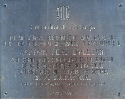
Pedro de Alberni, Captain of the Catalan Volunteers and Commander of the Spanish Establishment at Santa Cruz de Nootka, 1790-1792.
Offered by the Government of Spain on the occasion of the visit of the Spanish . . . — — Map (db m9155) HM
Directly behind the Ross Fountain lies Tod Inlet and the site of the Vancouver Portland Cement Company established in 1904. Adjacent to the plant at Tod Inlet was a village that housed the employees. — — Map (db m74444) HM
In 1858, nearly 800 free Blacks left the oppressive racial conditions of San Francisco for a new life on Vancouver Island. Governor James Douglas had invited them here as promising settlers. Though still faced with intense discrimination, these . . . — — Map (db m72868) HM
Town of Sidney
BC Spirit Squares
Beacon Park Pavilion
Opened June 28, 2009
by the Honourable Steven Point,
Lt. Gov. of BC
A legacy of the 150th anniversary of the founding of the Crown Colony of British Columbia . . . — — Map (db m75464) HM
Before town planning and notions of the picturesque, waterfronts were convenient for industrial development. As a transportation hub, Sidney's waterfront boasted a sawmill, a cannery, boatworks and roofing plant, besides rail and ship . . . — — Map (db m75465) HM
The Burrell family home, "Summerdyne", on Oak Bay Avenue at Monterey looking west - circa 1906
The Burrell family walking east along Oak Bay Avenue near their home - circa 1900 — — Map (db m75299) HM
Before 1903 the remains of early Chinese immigrants were buried in the low-lying, southwestern corner of Ross Bay cemetery. This area was often flooded after a heavy rainstorm. In the early 1900s, high winds and waves eroded a few waterfront . . . — — Map (db m75449) HM
was erected by Hudson’s Bay Company
1843
Here Colony of Vancouver’s Island was inaugurated by Richard Blanshard 1850
Vancouver’s Island and British Columbia united 1866
Two years later Victoria became the capital of British Columbia — — Map (db m48547) HM
Project of Native Indians' Participation Centennial Sub-Committee
to commemorate
the Union in 1866 of the colonies
on Vancouver Island and the mainland as
British Columbia
Kwakiutl Bear Pole
carved by
Mr. Henry Hunt of . . . — — Map (db m74399) HM
We would like to take a moment to share with you the history that you are standing over, around and next to.
This harbour was originally the sole domain of the Lekwungen First Nation who plied its protected waters and fished in their dugout . . . — — Map (db m48749) HM
[Three 'markers' a part of this mural. They are entitled: Pemberton Family, Vancouver Island, and Fort Victoria.]
Pemberton Family
J.D. Pemberton, engineer and surveyor for the H.B.C., arrived in 1851 by canoe in the last stages of his . . . — — Map (db m48543) HM
Fort Victoria had its start in 1843, centered on Fort Street and present-day Bastion Square. Most of Victoria’s Old Town however was constructed during the great building boom of 1886-1892.
During that period the red-brick character of . . . — — Map (db m49225) HM
Came with their five children from Papa Westray, Orkney Isl[ands]. aboard the sailing ship Knight Bruce via Cape Horn. Arrived at Victoria on 24 Dec 1864 after 180 days at sea. — — Map (db m74706) HM
She came here in 1843 with her husband, Chief Trader Charles Ross, who was in charge of building Fort Victoria. After his death she bought the land upon which you are standing for a farm. By so doing she became the first woman to own land in . . . — — Map (db m74825) HM
This memorial commemorates the 150 Victorians of Japanese descent who are buried in this historic cemetery, beginning in 1887.
During the 1940's, when no person of Japanese descent was allowed to remain within 100 miles of the West Coast, . . . — — Map (db m74695) HM
Born in New Bedford
Massachussets [sic] in 1814
Died in Victoria in 1912
while a resident of
the Old Men's Home
He came to Victoria from California in 1858 and was appointed by Governor James Douglas as a police constable but racial . . . — — Map (db m74829) HM
First Bishop of British Columbia
who resigned after completing
nearly 34 years of untiring and
laborious work in this colony
He died at Parham Vicarage,
Suffolk, England
on December 10th 1895
and was buried 14th December
in the . . . — — Map (db m74752) HM
Baptized: March, Cambridgeshire, England
June 7 1817
Died: Victoria, B.C., Canada
July 11, 1894
On August 17 of 1862, Barker struck gold at 52 feet on Williams Creek, Cariboo. The town of Barkerville bears his name. Like many miners he . . . — — Map (db m74827) HM
ca. 1860
[Photo caption reads] A detail of the View of Victoria, 1860.
Major Bay is largely undeveloped.
BC Archives POP01538
1878
[Photo caption reads] Bird's-Eye View of Victoria, Vancouver Island, B.C. 1878, detail.
Drawn . . . — — Map (db m74383) HM
This area, designed and laid out by the landscape branch of the Provincial Department of Public Works in 1975, has been named Elliot Street Square, in memory of Andrew Charles Elliot, barrister, judge, gold commissioner, police magistrate, and . . . — — Map (db m48765) HM
[Medallions, top row]
Milton – Sophocles – Shakespeare – Socrates – Dante – Homer
[Statues, anti-clockwise from the top left]
Colonel R.C. Moody
1813-1887
Commander of Royal Engineers in 1858, erected New . . . — — Map (db m49045) HM
John Sebastian Helmcken arrived in Fort Victoria in 1850 to work as a physician for the Hudson’s Bay Company.
He remained here for the rest of his life, marrying Cecilia Douglas, the eldest daughter of Governor James Douglas. The young couple has . . . — — Map (db m96724) HM
Les ancêtres de la famille Côté son arrives au Québec en 1634. En 1945, Joseph Napoléon Côté et son épouse Ida Camille Demers, accompagnés de leur fils Joseph Henri Côté et son épouse Anne-Marie Forcade s’establissent à Victoria.
Le . . . — — Map (db m49228) HM
As the Helmcken family grew, so did this house. You can see three stages in the structure.
[Right section]
The original 1852 log cabin was built in a fur trade post-in-sill style with hand hewn squared logs and cedar shingles. Hearths in three . . . — — Map (db m48866) HM
Family home of William J. Pendray
Built 1897
Known as Loretto Hall
1940-1966
Restoration by William and Florence Prior
1970
Topiary gardens replanted by descendants of Mr. Pendray
1980
[Marker below, French]
Ancienne . . . — — Map (db m96725) HM
There are messages in the landscape here, surviving traditional place names, and the soil itself preserves ancient stories waiting to be told.
This is the land of the Lekwungen People, known today as the Esquimalt and Songhees Nations. As . . . — — Map (db m74378) HM
[English]
Justifiably described as “the father of British Columbia”, Douglas was born in Demerara. He joined the North West Company in 1819, serving at Fort William and Ile a la Crosse where he was taken into the Hudson’s Bay Company. . . . — — Map (db m48769) HM
British Columbia was formed from four British Colonies and territories:
The Crown Colony of Vancouver Island 1845
The Dependency of the Queen Charlotte Islands 1852
The Crown Colony of British Columbia 1856
The Stickeen . . . — — Map (db m49074) HM
Built for coal magnate Robert Dunsmuir, Craigdarroch symbolized the desire of late 19th-century industrialists to assert their social position through conspicuous displays of wealth. Completed in 1890, the eclectic mansion features . . . — — Map (db m72876) HM
This monument was erected by residents of Rockland, with the support of the City of Victoria, to commemorate the past, celebrate the millennium and look to the future.
Rockland was carved out of the 500 acre Douglas Estate “Fairfield . . . — — Map (db m75028) HM
A stone boundary marker set by the Royal Engineers 1859-60 as part of the original survey of Government House grounds and Fairfield Farm. — — Map (db m75001) HM
An original homestead representing the Hudson's Bay Company's efforts to farm and thereby stimulate settlement in the region through their subsidiary, the Puget's Sound Agricultural Company. Begun by the company and completed by the farm's first . . . — — Map (db m187873) HM
English:
A search for the source of placer gold found on lower parts of the Fraser River led to discoveries of lode mines in the Cariboo, of which Williams Creek, is said to have yielded $19,000,000. As a centre of population in the . . . — — Map (db m42712) HM
[English] This historic Bridge commemorates an achievement of the Doukhobors of Canada in establishing communal settlements in the Kootenay Boundary region of British Columbia during the early 20th century. Built in 1913 by community labour, . . . — — Map (db m197114) HM
As this community prospered in the 1890s, tent hotels and log stores gave way to ornate edifices, and Nelson changed from a crude mining camp into the "Queen City of the Kootenays." The gully that divided Baker Street in two was bridged in 1890, . . . — — Map (db m187922) HM
In the the early 1860s placer gold drew prospectors from all parts of the West to the Salmo River valley, and the Dewdney Trail from the west coast soon opened the region to increased travel. Development increased dramatically in 1893, when Daniel . . . — — Map (db m187931) HM
Father Pandosy, an Oblate priest, ministered to natives and white in widely separated parts of British Columbia for over 30 years, until his death in 1891.
His mission, with its church, school and farms established in 1859-60 on this site, formed . . . — — Map (db m187909) HM
An “instant” town of the past. In 1898 James Dunsmuir, the coal baron, moved buildings by rail from Wellington to establish this coal shipping port. Nearby copper mines added a smelter in 1902, but only pilings mark that site. Railroad logging aided . . . — — Map (db m187985) HM
Gold miners poured into this area in the 1860’s crossing the Kootenay River at the foot of this street. The settlement that grew up here was first called Galbraith’s Ferry.
In 1887 the N.W.M.P. established a post here when friction developed . . . — — Map (db m100115) HM
Kootenay gold discoveries attracted thousands of prospectors from Washington Territory in the late 1850s and 1860s. In those years all trails led south into Washington and Idaho and the vast bulk of the treasure and commerce enriched those regions. . . . — — Map (db m187913) HM
In 1841, Sinclair guided 200 Red River settlers from Fort Garry through the Rockies to Oregon in an attempt to hold the territory for Great Britain. By 1854 he had recrossed the mountains several times by routes which later were followed by trails . . . — — Map (db m187991) HM
Gone but still remembered — no formal boundaries
divided the communities of Natal, Michel and Middletown —
“home” to thousands of coal miners for generations. Workers
came from many parts of Europe and North America to toil
in these mines. . . . — — Map (db m187935) HM
From 1908-1911, determined Sikh Settlers laboured to build this Gurdwara in the face of much racial discrimination. The temple served as a place of solace for new immigrants in difficult times. A National Historic Site, today it stands as a . . . — — Map (db m187881) HM
With the first wave of impetuous gold seekers in 1858, the Chinese came to B.C. Following the roving white miners, these industrious and patient people gleaned the gold that others failed to mine. With baskets and hand tools they helped to build the . . . — — Map (db m187906) HM
This was the head of navigation on the Fraser River. Founded in 1848, as a Hudson's Bay Company fur post, Fort Yale later became a roaring gold-rush town and for 20 years was the starting point of the famous Cariboo Wagon Road. Yale faded with the . . . — — Map (db m187996) HM
Community Building
The first permanent structure in Elgin was the Elgin Hotel (1870). It was built as a convenient stop-over point for travellers between New Westminster and Blaine.
In 1875, four years before the incorporation of the . . . — — Map (db m60900) HM
Settlement History
First Nations settlements and seasonal hunting and fishing camps existed at the mouths of rivers and along the coastal shoreline for thousands of years before Europeans reached the West Coast. These sites were near . . . — — Map (db m60901) HM
Upper marker:
This unfortified boundary line between the
Dominion of Canada
and the
United States of America
should quicken the remembrance of the more than century old friendship between these countries
A lesson of peace . . . — — Map (db m27450) HM
John Deighton was born in Hull, England. He was an adventurer, river boat pilot and captain, but best known for his "gassy" monologues as a saloonkeeper. His Deighton House Hotel, erected here on the first subdivided lot, burned in the Great . . . — — Map (db m40204) HM
Here stood
Hamilton
First Land Commissioner
Canadian Pacific Railway
1885
in the silent solitude
of the primeval forest
He drove a wooden stake
in the earth and commenced
to measure an empty land
into the streets of . . . — — Map (db m40645) HM
Head of sternwheeler navigation on the Skeena. The town grew at the landing close to the Indian village of Gitenmaks. Crews from the Collins Telegraph arrived in 1866. Following them Omineca gold miners, Hudson’s Bay pack strings and “gandy . . . — — Map (db m9073) HM
Although prospectors like "Jolly Jack” Thorton worked this area during the 1860s, Boundary Falls was not settled until the 1890s, when a new breed of miners flooded the district. Surrounded by mining properties, the Boundary Falls Smelter (also . . . — — Map (db m187917) HM
Cascade came into being during the late-1890s as a bustling railway construction town claiming 17 hotels at its height. Its location along the Canada-U.S. border proved strategic for mining, freighting, and hydro-electricity. The early development . . . — — Map (db m187915) HM
During the prosperous years of the late 1890s, this street was one of the busiest thoroughfares in the province. Little wonder, for in those years copper was king, and Greenwood — incorporated as a city in 1897 — was the capital of the copper-rich . . . — — Map (db m187914) HM
Proximity to Boundary Creek mines, and excellent climate, water and soil convinced Midway promoters of a bright future as a "railway and residential town.” The Columbia & Western Railway reached Midway in 1900; five years later, the Vancouver, . . . — — Map (db m187938) HM
Once a thriving logging town, the downtown of Vancouver's skyline is now dominated by
residential and retail developments, corporate headquarters, hotels and the distinctive
"sails" of the convention and cruise ship centre. The City of Vancouver . . . — — Map (db m236126) HM
In the area then known as West Capilano, and today as Ambleside, a former Canadian Pacific Railway conductor. John Lawson, purchased land in 1906. He moved his family there the following year, Lawson had big ideas for his land, which he christened . . . — — Map (db m235892) HM
This grassy area, now Devonian Harbour Park, represents lavers of historic use from early settlement to industrial waterfront.
Coal Harbour
In 1859 Captain George Henry Richards from the British Royal Navy named this bay Coal Harbour, . . . — — Map (db m235893) HM
This clock is located at the western boundary of the old Granville townsite, known as Gastown. In 1870, the shore of Burrard Inlet was only a few yards north of this point. Through the early 1900's, Gastown was the commercial centre of Vancouver. . . . — — Map (db m236389) HM
George Leslie's Lane Cottage
Builder: George Leslie
This circa 1901 Yaletown home was relocated to Mole Hill in 2002 and restored by the Vancouver Heritage Foundation. It was originally situated on the lane at [t]he rear of . . . — — Map (db m236746) HM
Commemorating the pioneering of the work of the Salvation Army in Vancouver. It was on this clearing the Salvation Army erected a rugged shelter, picnic tables, and then held services of song. In the silent atmosphere of early Burrard Inlet, the . . . — — Map (db m236209) HM
Roedde House
Attributed to Francis Mawson Rattenbury
This Queen Anne style home of Vancouver's first bookbinder was built by Gustav and Matilda Roedde in 1893. Efforts to restore the house and establish a unique heritage park . . . — — Map (db m236348) HM
Originally built as The Sunnyside Hotel in 1874, the property was devastated by the Great Vancouver Fire in 1886. It was rebuilt and operated as The Alexandra Hotel for several years. As of 1912, the building was home to Swift Canadian Company, a . . . — — Map (db m236457) HM
This sundial commemorates three English Greenhorns Samuel Brighouse, John Morton, and William Hailstone who in 1862 filed the first claim and planned the first home and industry in the heavily wooded area now bounded by Burrard Inlet, Stanley Park, . . . — — Map (db m236361) HM
Grocer Fred Welsh was the first owner of this home which was built in 1894 during the early development of the Mount Pleasant neighbourhood. This Queen Anne style cottage has elaborate wooden decoration including delicate brackets, shingles and . . . — — Map (db m236645) HM
This 1908 house is a good example of the Edwardian Builder style which was popular during the city's building boom in the early years of the 20th century. These wooden frame buildings were often two and a half stories with a full front porch simple . . . — — Map (db m236641) HM
Like its neighbour at 118 West 10th Avenue, this house is characteristic of Edwardian design which was popular in the early 20th century. The upper storey balcony with its arched opening and balustrade is a particular attractive feature. This house . . . — — Map (db m236639) HM
JC. Turnbull built and briefly lived in this 1909 Queen-Anne-styled home. It was later acquired by Jacob Grauer, a postmaster at Eburne, whose sons became public figures. The front facade features outstanding ornamentation, coloured glass windows, . . . — — Map (db m236647) HM
From Kuchinotsu, Japan, Manzo was the first known Japanese immigrant to Canada. In March 1877, at age 24, he left Japan for North America aboard a British steamer, arriving in May in British Columbia. He fished near Rivers Inlet and eventually . . . — — Map (db m236652) HM
Nye’s Gas Station
Architects: Townley and Matheson
The firm of Townley and Matheson, best known for designing Vancouver's City Hall further up Cambie Street, designed this early brick gas station in 1922 for Captain Percival Nye . . . — — Map (db m236701) HM
This rare surviving 1894 Victorian home was one of the first homes built in Fairview Slopes. Within a decade houses covered the entire neighbourhood. Shaw House draws from the Italianate style with elements of the Eastlake style, such as elaborate . . . — — Map (db m236698) HM
Nanaimo was founded as a coal-mining settlement in 1852. Its most productive mine, No. 1, opened in 1881. From the bottom of the main shaft, one-half mile south of here, a labyrinth of workings extended for miles under the sea. These operations were . . . — — Map (db m187983) HM
In 1869 Robert Dunsmuir discovered coal in this area. The settlement of Wellington developed after 1871 when coal was transported first by wagon and later by rail to wharves at Departure Bay. When the mines closed in 1900, many of Wellington's . . . — — Map (db m187948) HM
“And our eyes feasted on the
long stretch of prairies…” wrote
A. L. Fortune, first settler in
this fertile valley, in June, 1866.
The natural meadows, rippling in
tall grasses, were ideal pasture
for cattle and sheep. Later, grain
replaced . . . — — Map (db m187929) HM
The valley's potential was seen by Forbes and Charles Vernon in 1863, when travelling to silver claim staking 40 miles to the east. In 1864, the brothers pre-empted across the lake 1000 fertile acres which became Coldstream Ranch. Its products . . . — — Map (db m188020) HM
For many thousands of years S ukwnaqinx (later Anglicized to "Okanagan") travelled and peopled a far-reaching territory. Though their main camp was centred at Penticton, this valley was used as a food gathering base-camp. . . . — — Map (db m187910) HM
The 1890's held high hopes for the lode gold of mines such as Stemwinder, Morning Star, and Rattler. By 1902, when the Fairview Hotel or "Big Teepee" burned, the golden years were over. Fairview's population dwindled as miners left for more . . . — — Map (db m188011) HM
Salmon canning stimulated economic development on this coast. North Pacific is the oldest West Coast cannery still standing. From here the Bell-Irving family shipped high quality salmon directly to England before 1900. Typical of most canneries in . . . — — Map (db m9203) HM
In 1898, Fritz Miller and Kenny McLaren found gold on nearby Pine Creek, triggering British Columbia's last placer gold rush. The boom subsided by 1908, but gold has kept Atlin alive. Now Miller and McLaren lie here among hard bitten prospectors, . . . — — Map (db m188029) HM
In 1862 C.F. and H.P. Cornwall settled here and developed Ashcroft Manor. The ranch, with its grist and saw mills, supplied Cariboo miners. The manor house was destroyed by fire in 1943, but the road house survives. Clement Cornwall became one of . . . — — Map (db m187921) HM
Here bloomed a “Garden of Eden”! The sagebrush desert changed to orchards through the imagination and industry of English settlers during 1907-14. Then the men left to fight - and die - for king and country. A storm ripped out the vital irrigation . . . — — Map (db m188008) HM
It had been an epic struggle against the wilderness for the gold-seekers from Eastern Canada.
They had crossed the Rockies, trekked through pathless forests and won the swift rapids of the North Thompson River. The open country now offered hope . . . — — Map (db m187979) HM